Baseline habitat parcels
Baseline habitat is the habitat that exists before a site is developed. Development sites often contain a mosaic of baseline habitats each of whose condition may vary. These are called habitat parcels.
The area of a habitat parcel is measured in hectares (or square metres when using the Small Sites Metric). Linear habitats parcels are measured in kilometres (or metres when using the Small Sites Metric).
The sum of all the ground-based area habitat parcels should equal the area of the proposed development site (the redline boundary).
Calculating HUs
The HU calculation uses the following formula:
HU = Habitat area/length x Distinctiveness x Condition x Strategic Significance.
The Distinctiveness of each habitat is predefined. These are the Distinctiveness scores:
| Very High | 8 |
| High | 6 |
| Medium | 4 |
| Low | 2 |
| Very Low (hedgerow module) | 1 |
| Very Low (area module) | 0 |
The Condition of a habitat is assessed using the various matrices set out in Statutory biodiversity metric condition assessments published by Defra. These are the scores:
| Good | 3 |
| Fairly Good | 2.5 |
| Moderate | 2 |
| Fairly Poor | 1.5 |
| Poor | 1 |
| Condition Assessment N/A | 1 |
| N/A – Other | 0 |
The Strategic significance of a habitat is its importance according to its location and habitat type. Each of these elements is given a score which is then used in the HU formula. These are the scores:
| High | 1.15 |
| Medium | 1.1 |
| Low | 1 |
For example, an area habitat parcel covering a hectare, which is of medium distinctiveness, in moderate condition and of medium strategic significance, is calculated as follows:
1 ha (area) x 4 (distinctiveness) x 2 (condition) x 1.1 (strategic significance) = 8.8 HUs.
Individual trees habitat
There is a special formula for individual trees habitats. This is because they oversail the habitat on the ground and so are non- ground-based habitats, which need to be treated differently from ground-based habitats.
This table shows the four size classes for Individual trees habitats:
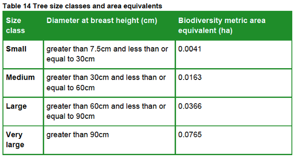
It uses the diameter at breast height (DBH measured 1.5 metres above the ground) of each tree growing on a proposed development site (if the tree is multi-stemmed, the largest DBH recorded is used) and assigns a ‘Biodiversity metric area equivalent’ to calculate its habitat area. This value represents canopy biomass, and is based on (but not the same as) the root protection area formula, derived from BS 5837:2012.
For example, a medium-size individual trees habitat covers an area of 0.0163 ha and has medium Distinctiveness. If it is in moderate Condition and of medium Strategic significance the HU value is calculated as follows:
0.0163 ha (area) x 4 (distinctiveness) x 2 (condition) x 1.1 (strategic significance) = 0.14344 HUs.
Post-development habitat creation and enhancement
The biodiversity metric also applies three additional risk factors to all post-development enhanced and created habitat parcels, across all three habitat types – Area, Hedgerow and Watercourse – using this formula:
HU = Habitat area/length x Distinctiveness x Condition x Strategic Significance x Temporal Risk x Difficulty factor x Spatial Risk
Temporal risk
This represents the average time lag between the start of habitat parcel creation or enhancement works and the target outcome date. This is known as the ‘time-to-target condition’ and is measured in years.
If there is a delay in creating or enhancing the habitat parcel, or it has already been enhanced or created, this can be factored in to adjust the time-to-target period either up or down.
The temporal risk period is automatically applied by the biodiversity metric and changes depending on target habitat condition. As a result, the temporal risk multiplier, based on the 3.5% discount table below, sets the current value of the future habitat being created.

Difficulty of creation or enhancement
The creation and enhancement categories represent the uncertainty of the effectiveness of techniques to create or enhance habitat parcels.
The biodiversity metric automatically assigns the delivery risk and score for each habitat parcel, based on its habitat intervention category.
| Category | Value |
| Low | 1 |
| Medium | 0.67 |
| High | 0.33 |
| Very High | 0.1 |
Spatial risk
Where a project cannot achieve a net gain in biodiversity units on site, then offsite HUs can be used to meet the BNG requirement.
The spatial risk penalty (SRM) reflects the relationship between the location of on-site biodiversity loss and the location of off-site habitat compensation. It affects the number of biodiversity units provided to a project by penalising proposals where off-site habitat is located at a distance from the development site.
- If the offsite area is within Local Planning Authority (LPA) boundary or National Character Area (NCA), the penalty is x 1.0.
- If it is in a neighbouring LPA or NCA, the penalty is x 0.75.
- If it is elsewhere (anywhere in England), the penalty is x 0.5.
The effect of this is that it costs more HUs to achieve the BNG requirement the farther away the offsite mitigation is from the location of on-site biodiversity loss.
Post-development Individual trees habitat creation
When creating Individual trees habitat, post-development size class of a tree is determined by its size when it is planted. Newly planted trees should be recorded as small-sized, unless the tree is actually medium-sized or above at the time of planting.
In our experience, nearly all nursery-grown trees are small-sized, as this table, derived from BS 3936-1, demonstrates.

For example, a small-sized tree covers an area of 0.0041 ha and has medium Distinctiveness. The difficulty of creation factor is preset at Low.
If it is planned for it to achieve a moderate Condition, the time-to-target period will be 27 years. If it is planted within the LPA in an area of medium Strategic significance, its HU value will be calculated as follows:
0.0041 ha (area) x 4 (distinctiveness) x 2 (condition) x 1.1 (strategic significance) x 0.382 (temporal risk) x 1 (difficult factor) x 1 (spatial risk) = 0.01378 HUs.
Other Blogs in the series

One thought on “BNG – valuing habitats”