There are six criteria for assessing a tree’s condition. If a tree passes five or six of the criteria, it is in good condition. If it passes three or four of the criteria, it is in moderate condition. If it passes two or fewer of the criteria, it is in poor condition.
These are the six criteria to consider:
A – The tree is a native species (or at least 70% of the block are native species). B – The tree canopy is predominantly continuous, with gaps in canopy cover making up <10% of total area and no individual gap being >5 m wide (individual trees automatically pass this criterion). C – The tree is mature (or more than 50% of the block are mature). D – There is little or no evidence of an adverse impact on tree health by human activities (such as vandalism, herbicide or detrimental agricultural activity). And there is no current regular pruning regime, so the trees retain >75% of expected canopy for their age range and height. E – Natural ecological niches for vertebrates and invertebrates are present, such as deadwood, cavities, ivy and loose bark. F – More than 20% of the tree canopy area is oversailing vegetation beneath.
The ‘Fairly Good’ and ‘Fairly Poor’ condition categories are not available for this habitat type.
Enhancement of this habitat is only possible by improving it so that it meets the criteria B, D and F. It is not possible or appropriate to enhance individual tree/s through meeting just one or two of these criteria, nor by meeting only A or C or E.
It is important that the species of each tree on site is properly listed by the developer. Here is the list of the native species defined by the Statutory Metric:
With the introduction of the Biodiversity Metric, all existing (i.e. baseline) habitat parcels on proposed development sites are given a calculated habitat value, called Habitat Units (HUs).
Baseline habitat parcels
Baseline habitat is the habitat that exists before a site is developed. Development sites often contain a mosaic of baseline habitats each of whose condition may vary. These are called habitat parcels.
The area of a habitat parcel is measured in hectares (or square metres when using the Small Sites Metric). Linear habitats parcels are measured in kilometres (or metres when using the Small Sites Metric).
The sum of all the ground-based area habitat parcels should equal the area of the proposed development site (the redline boundary).
Calculating HUs
The HU calculation uses the following formula:
HU = Habitat area/length x Distinctiveness x Condition x Strategic Significance.
The Distinctiveness of each habitat is predefined. These are the Distinctiveness scores:
The Strategic significance of a habitat is its importance according to its location and habitat type. Each of these elements is given a score which is then used in the HU formula. These are thescores:
High
1.15
Medium
1.1
Low
1
For example, an area habitat parcel covering a hectare, which is of medium distinctiveness, in moderate condition and of medium strategic significance, is calculated as follows:
1 ha (area) x 4 (distinctiveness) x 2 (condition) x 1.1 (strategic significance) = 8.8 HUs.
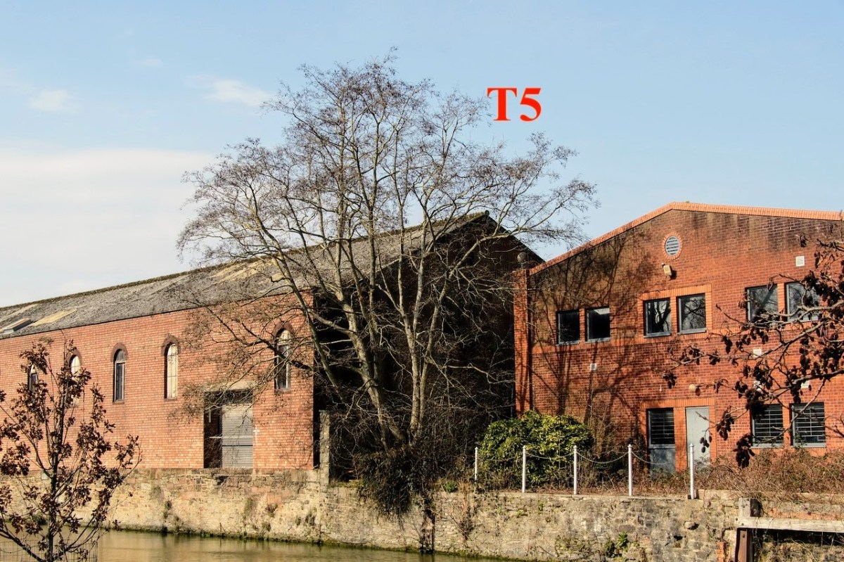
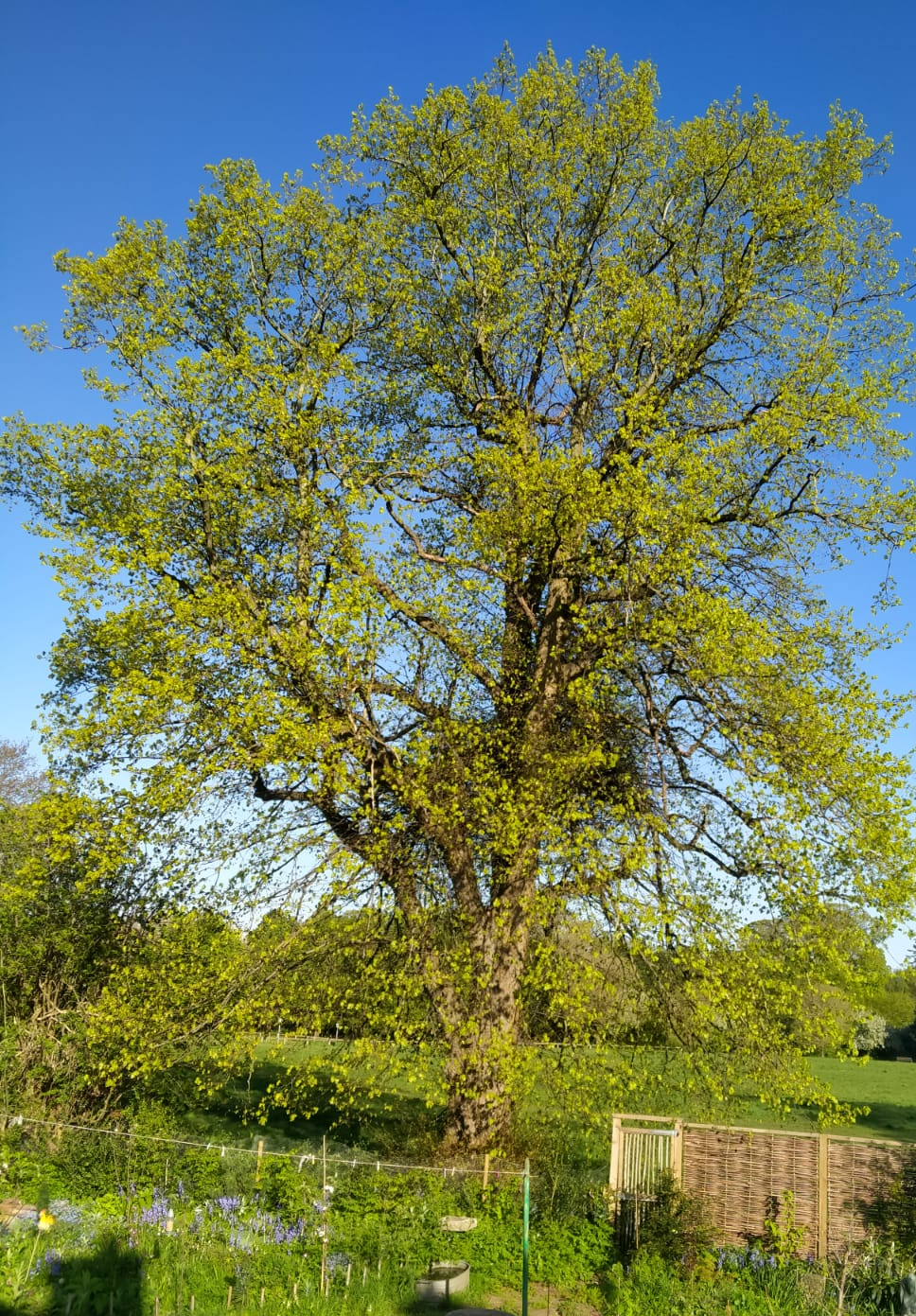
Individual trees habitat
There is a special formula for individual trees habitats. This is because they oversail the habitat on the ground and so are non- ground-based habitats, which need to be treated differently from ground-based habitats.
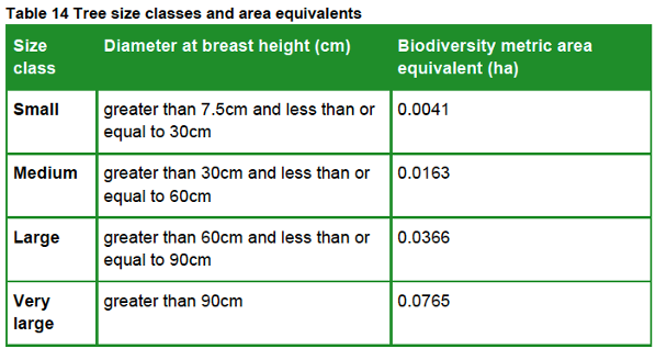
This table shows the four size classes for Individual trees habitats:
It uses the diameter at breast height (DBH measured 1.5 metres above the ground) of each tree growing on a proposed development site (if the tree is multi-stemmed, the largest DBH recorded is used) and assigns a ‘Biodiversity metric area equivalent’ to calculate its habitat area. This value represents canopy biomass, and is based on (but not the same as) the root protection area formula, derived from BS 5837:2012.
For example, a medium-size individual trees habitat covers an area of 0.0163 ha and has medium Distinctiveness. If it is in moderate Condition and of medium Strategic significance the HU value is calculated as follows:
0.0163 ha (area) x 4 (distinctiveness) x 2 (condition) x 1.1 (strategic significance) = 0.14344 HUs.
Post-development habitat creation and enhancement
The biodiversity metric also applies three additional risk factors to all post-development enhanced and created habitat parcels, across all three habitat types – Area, Hedgerow and Watercourse – using this formula:
HU = Habitat area/length x Distinctiveness x Condition x Strategic Significance x Temporal Risk x Difficulty factor x Spatial Risk
Temporal risk
This represents the average time lag between the start of habitat parcel creation or enhancement works and the target outcome date. This is known as the ‘time-to-target condition’ and is measured in years.
If there is a delay in creating or enhancing the habitat parcel, or it has already been enhanced or created, this can be factored in to adjust the time-to-target period either up or down.
The temporal risk period is automatically applied by the biodiversity metric and changes depending on target habitat condition. As a result, the temporal risk multiplier, based on the 3.5% discount table below, sets the current value of the future habitat being created.
Difficulty of creation or enhancement
The creation and enhancement categories represent the uncertainty of the effectiveness of techniques to create or enhance habitat parcels.
The biodiversity metric automatically assigns the delivery risk and score for each habitat parcel, based on its habitat intervention category.
Category
Value
Low
1
Medium
0.67
High
0.33
Very High
0.1
Spatial risk
Where a project cannot achieve a net gain in biodiversity units on site, then offsite HUs can be used to meet the BNG requirement.
The spatial risk penalty (SRM) reflects the relationship between the location of on-site biodiversity loss and the location of off-site habitat compensation. It affects the number of biodiversity units provided to a project by penalising proposals where off-site habitat is located at a distance from the development site.
If the offsite area is within Local Planning Authority (LPA) boundary or National Character Area (NCA), the penalty is x 1.0.
If it is in a neighbouring LPA or NCA, the penalty is x 0.75.
If it is elsewhere (anywhere in England), the penalty is x 0.5.
The effect of this is that it costs more HUs to achieve the BNG requirement the farther away the offsite mitigation is from the location of on-site biodiversity loss.
Post-development Individual trees habitat creation
When creating Individual trees habitat, post-development size class of a tree is determined by its size when it is planted. Newly planted trees should be recorded as small-sized, unless the tree is actually medium-sized or above at the time of planting.
In our experience, nearly all nursery-grown trees are small-sized, as this table, derived from BS 3936-1, demonstrates.
For example, a small-sized tree covers an area of 0.0041 ha and has medium Distinctiveness. The difficulty of creation factor is preset at Low.
If it is planned for it to achieve a moderate Condition, the time-to-target period will be 27 years. If it is planted within the LPA in an area of medium Strategic significance, its HU value will be calculated as follows:
0.0041 ha (area) x 4 (distinctiveness) x 2 (condition) x 1.1 (strategic significance) x 0.382 (temporal risk) x 1 (difficult factor) x 1 (spatial risk) = 0.01378 HUs.
Much has been made of the new rules that require most developments to add at least 10% more biodiversity to a site than was present before development took place. This requirement is known as biodiversity net gain (BNG).
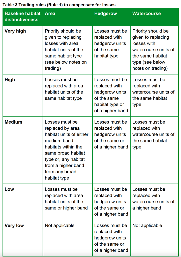
However, a much-overlooked aspect of the new rules is the requirement also to comply with so-called trading rules.
These trading rules set minimum requirements for habitat creation and enhancement to compensate for specific habitat losses resulting from a new development.
If these rules are not followed, a developer cannot claim that there is biodiversity net gain, even if the planning application has achieved the minimum 10% BNG required.
Rule 2 states that biodiversity unit outputs for each habitat type – Area, Hedgerow or Watercourse – must not be added together, traded, or converted between types. The requirement to deliver at least a 10% net gain applies to each separate habitat type.
The trading rules only apply to the point of no net loss of a specific habitat. Once the trading rules have been met for this habitat, the biodiversity net gain requirements can be met by the creation and enhancement of any other habitat, provided it is the same habitat type.
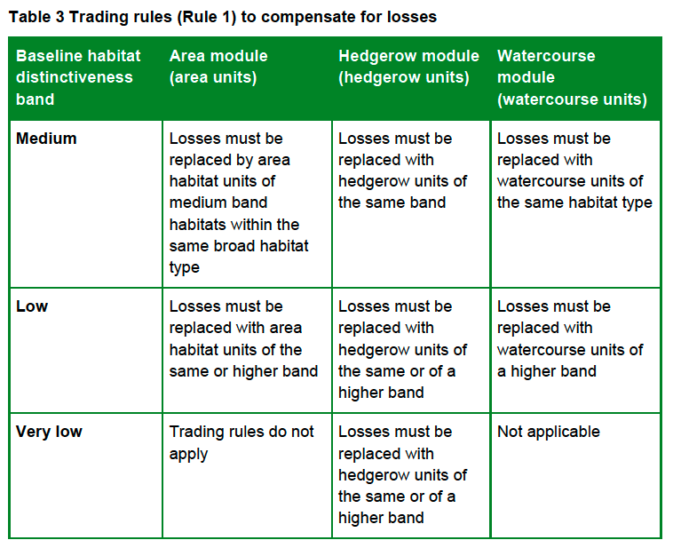
This table from the Statutory Metric sets out how they apply:
The trading rules for the SSM are slightly different. This is because the SSM does not cater for high and very high distinctiveness habitats (if these are present, the Statutory Metric must be used):
Although the calculator warns of any breaches of the trading rules, the design of the SSM does not allow users to identify where the breaches have occurred. However, the Statutory Metric does. So, if the habitats input into the SSM calculator are transposed to the Statutory Metric calculator, this will reveal where the trading rules breaches are and allow the user to consider how to mitigate the losses whilst still complying with the trading rules.
There are special rules for very high distinctiveness habitats and for compensating for loss of watercourses and high distinctiveness woodland, which are not addressed here.
How the trading rules apply to urban tree habitats
Individual trees habitat has medium distinctiveness. This means that this habitat can only be replaced like for like, although higher distinctiveness habitats can be substituted when the Statutory Metric is used.
Other broad habitats with the same distinctiveness cannot be substituted. For example, Woodland and forest habitat cannot be used to replace lost Individual trees habitat unless it has a higher distinctiveness and the SSM is not being used.
As a result, the requirement to replace lost trees can result in many more trees having to be planted (often off site) than will be lost. In one recent example we examined, 116 replacement trees were needed to comply with the trading rules, even though only 12 were being removed.
Hopefully, developers will now think twice before seeking to remove trees to make way for their plans.