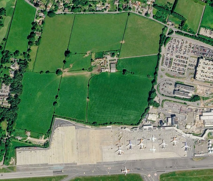
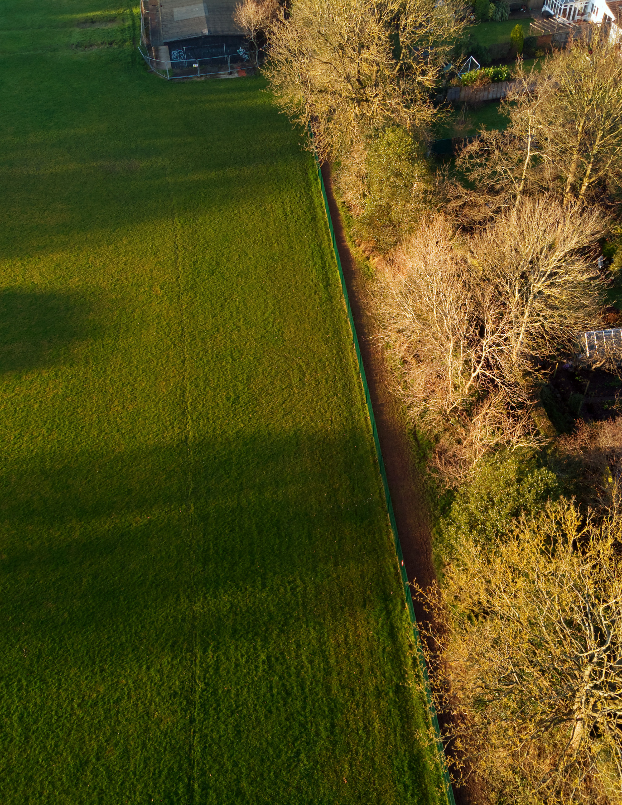
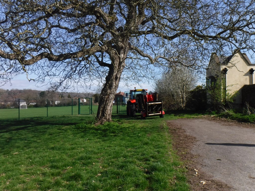
So far, most of the public alarm about this expansion has centred on Felton Common, the well-loved local nature reserve on the other side of the runway, where the airport wants to plant 8.5-metre approach lights and fencing across protected grassland. Campaigners under the Save Felton Common banner have campaigned hard against that ‘land grab’, and rightly so. But the fierce fight over the Common has largely overshadowed a second, quieter yet important threat next door — the loss of irreplaceable habitat at Cook’s Farm, which has drawn far less attention. That is what our objection is chiefly concerned with.
Bristol Airport wants to grow. Its planning application (ref. 26/P/0686/OU2) seeks permission to expand from 12 million passengers a year to 15 million. To do this, the airport needs more land — including Cook’s Farm, some 24 hectares of long-established agricultural countryside where hedgerows have stood since at least the 1840s and where some trees have been growing for centuries. The airport now proposes to compulsorily purchase the site so it can carry out its plans.
However, it first needs to persuade the planners that its proposal is acceptable. We say it’s not, and we’ve lodged a detailed objection. It is a technical document, full of hectares and habitat codes, but underneath the detail is a simple story: irreplaceable habitat is at risk, the evidence supporting the plans doesn’t add up, and the law says that should matter.
Here is what our objection says, in plain terms.
The heart of it: three veteran trees
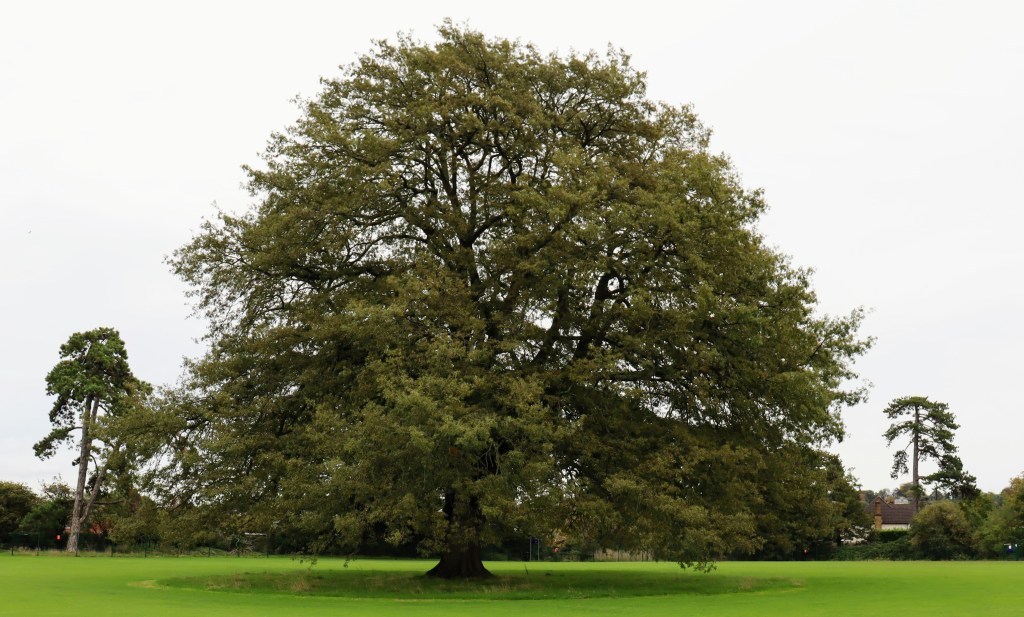
The most emotive part of the case concerns three veteran trees growing in an ancient hedgerow on the boundary of Cook’s Farm — two Ash and one Sycamore. The airport doesn’t propose to simply cut them down. Instead, it plans to translocate them: lift them with a giant tree spade and replant them on the northern edge of the development.
That might sound like a reasonable compromise, but our objections explain why it’s not in careful detail.
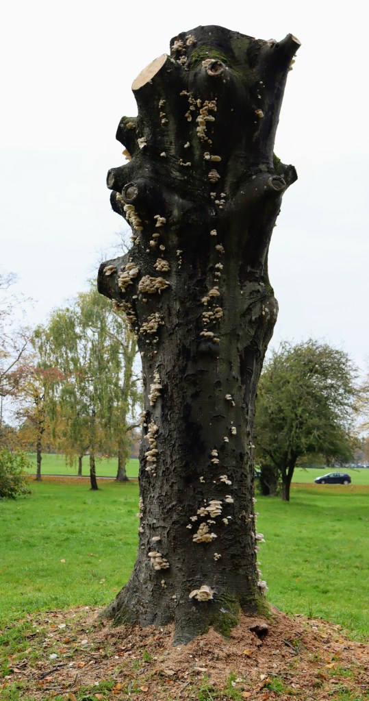
A veteran tree isn’t just an old tree, especially those in long-established hedgerows. It’s a whole ecosystem — cavities, rot, deadwood and fungal growth that specialist insects, fungi and other wildlife depend on and cannot find anywhere else. These features take centuries to form. You cannot manufacture them, and you cannot move them.
Worse, veteran trees are extremely unlikely to survive being moved. Their biology works against them. Over centuries they’ve spent their reserves coping with drought, storms, disease and damage, leaving little in the tank to survive the shock of relocation. Their roots are extensive but fragile, they depend on specialised underground fungal networks built up over generations, and much of their internal wood is effectively dead but structurally essential — it can’t be repaired if damaged. Successful relocation needs around two full growing seasons of careful root preparation beforehand. Crucially, the airport’s plan makes no proposal to reduce the trees’ roots at all. As our objection bluntly puts it: if the trees are translocated without root reduction, they will die.
Our conclusion is that, for the purposes of a planning decision, these three veteran trees should be treated as lost. The airport itself seems to half-accept this: it promises a ‘compensation’ package of ten new future veteran trees and the artificial ‘veteranisation’ of ten existing trees. But you can’t conjure a veteran tree on demand. Even with the right conditions, it takes two or three decades for a ‘veteranised’ tree to start resembling the real thing — and it will still lack the fungal decay that gives a true veteran its ecological value.
The evidence doesn’t add up
Beyond the trees themselves, we found that the environmental evidence supporting the application is riddled with inconsistencies. This means that the application can’t properly be decided as it stands.
The airport is required to demonstrate that it will deliver ‘Biodiversity Net Gain’ — a calculation meant to prove development leaves nature in a measurably better state (at least 10%) than it was before development. But our objection shows the numbers in the official metric calculation simply don’t match the airport’s own ecological survey. The two documents use different habitat categories, different reference codes, and don’t cross-reference each other. Some habitats that appear in the survey are missing from the metric altogether. Habitat parcels aren’t sized, and their locations aren’t shown on the map. In short, it’s impossible to reconcile the airport’s own datasets.
The tree surveys are a particular problem. Three surveys tucked into the appendices fail to meet BS5837:2012, the British Standard for trees in planning. Between them they’re missing the surveyors’ names and qualifications, survey dates, crown-spread data, branch heights and directions, life-expectancy estimates, soil assessments, and even the number of trees in some groups. One key survey dates from June 2024 and is now out of date. And when we asked for the tree schedule in a usable spreadsheet format so we could check it, our request was refused — leaving them, in their words, to analyse the data ‘as best we can’.
Even working with that inadequate evidence, their interim analysis is striking. Of roughly 1,618 individual trees on the site, some 367 — more than a fifth — are set to be removed, along with a share of the site’s hedgerows, which the airport’s own figures and the survey record in wildly different numbers (10 hedgerow parcels in one document, 71 in another).
Why this is a matter of law, not just sentiment
This is where our objection turns from ecology to policy — and it’s the part that could decide the outcome.
National planning rules are clear about irreplaceable habitats. Paragraph 193(c) of the National Planning Policy Framework says development that causes the loss or deterioration of irreplaceable habitats — and it names ancient and veteran trees specifically — ‘should be refused, unless there are wholly exceptional reasons and a suitable compensation strategy exists’.
We make two arguments about this test:
First, it’s a two-part test that has to be met in sequence: you need both wholly exceptional reasons and a suitable compensation strategy. A compensation package — however good, and here they say it isn’t good — cannot on its own make the reasons ‘wholly exceptional’. The decision in Juden v London Borough of Tower Hamlets [2021] EWHC 1368 (Admin) backs this interpretation.
Second, we argue that this scheme doesn’t clear the ‘wholly exceptional’ bar at all. The Framework’s own example of exceptional reasons is nationally significant infrastructure — the kind of once-in-a-generation project decided by government. This application, we say, is simply about increasing the capacity of an existing airport. That’s not the sort of wholly exceptional circumstance the rules have in mind.
Our objection also points to local policy. North Somerset Council’s own adopted Core Strategy (Policy CS4) requires it to protect, connect and enhance important habitats, ‘particularly designated sites, ancient woodlands and veteran trees’. The same protection is included in the Council’s emerging 2041 Local Plan. Approving the loss of these veteran trees would go against the Council’s own rules.
What it comes down to
Strip away the appendices and the acronyms, and our case is straightforward. The airport wants to expand on to land that includes centuries-old, irreplaceable habitat. Its plan to ‘move’ three veteran trees is, on the evidence, a plan to kill them slowly. The paperwork meant to justify all this is inconsistent, incomplete and in places non-compliant with the relevant standards. National and local planning policy both say irreplaceable habitat like this should be protected, not traded away for extra passenger numbers.
Our central demand is modest but firm: these problems need to be resolved before the application can properly be decided. For anyone who cares about Cook’s Farm, its ancient hedgerows and the veteran trees growing in them, that’s the line worth holding.
The Mayor has now published the next iteration of the proposed new Local Plan (LP). This will be brought before you at Full Council on 31 October next. The Mayor recommends (item 8) that, under Regulation 19 of the Town and Country Planning (Local Planning) (England) Regulations 2012, the draft LP will be formally published in order for representations to be made and then submitted to the Secretary of State for examination.
The sustainability appraisal documents are published on the Local Plan Review web page.
In our opinion the proposed LP is not yet ready for further consultation, let alone independent examination, for the following reasons:
It does not contain enough detailed information about the sites in the adopted LP to allow for a proper consultation or independent examination.
Protection for green spaces has been reduced, contrary to adopted Council policy.
Despite the recent Ecological and Climate Emergency Declarations, this draft provides fewer environmental protections than the adopted LP.
Comments on earlier drafts appear largely to have been ignored, rendering the consultation process flawed.
Our response in detail
Section 20 (2) of the Planning and Compulsory Purchase Act 2004 states that the authority must not submit the proposed LP unless they think the document is ready for independent examination. In our view, the proposed LP is not yet ready for further consultation, let alone independent examination. Our reasons are set out in detail below:
A proper consultation has not been conducted. In a 2001 judgement Lord Woolf defined a proper consultation as containing four elements.[1] The final element is that ‘the product of consultation must be conscientiously taken into account when the ultimate decision is taken’. You have not responded to our carefully considered comments on both the 2019 and the 2022 consultations on earlier drafts of the LP and there is no evidence that the Local Plan Working Party even discussed them. We do not know how many other organisations who submitted comments were also ignored, because these have not been published.
When the 2019 document, New Protection for Open Space, was published for consultation, a schedule with maps was produced so that consultees could see which sites were being proposed and with what designation – Local Green Space (LGS) or Reserved Open Space (ROS). No such document has been produced in this version, which means that there is no easy way for consultees to see what has been changed, added or removed – save for slavishly working though the only document showing the new designations set out in 08.3 Appendix A3 Policies Map. Whilst this may be sufficient for those interested only in the information at ward level, it is nigh on impossible for those with a city-wide interest.
An interactive GIS map of the proposed Bristol Local Plan Policies Map should be made available to facilitate examination. The pdf version provided has 38 layers in the Key and many sites have multiple designations, which makes it very difficult to interpret. The current Local Plan Policies map does this.
Whilst the document Appendix 3 Assessing the effects of the Publication Version Policies, cross-references, to a limited extent, how some proposed new policies relate to policies in the adopted LP, there is no equivalent schedule for the adopted policies which will be removed – Core, Site Allocation and Development Management Policies (SADMP) and ancillary Supplementary Planning Documents (SPDs) etc. – nor any comprehensive cross-tabulation showing which of the adopted LP policies have been transferred to the proposed LP and which have not.
No schedule has been prepared showing those sites protected under the adopted LP and whether they will be protected under the proposed LP. For example, SADMP DM17 currently provides protection for sites designated as Important Open Spaces, Unidentified Open Spaces and Urban landscapes. It appears that DM17 will be removed but that these current protections will not be adopted in the proposed LP. We have mapped 523 Important Open Space sites covering over 2,000 hectares. As far as we can see, some 1,000 hectares of these and all Unidentified Open Spaces and Urban landscapes, will no longer have any protection. If this is the case, then the proposals should make this clear. Our recent article, Will Councillors Honour Their Promise To Protect Bristol’s Green Spaces? addresses our wider concerns.
SNCIs are currently given protection from development under SADMP DM19. This states that ‘Development which would have a harmful impact on the nature conservation value of a Site of Nature Conservation Interest will not be permitted’. It is proposed that DM19 will be removed in its entirety. Under proposed new policy BG2: Nature conservation and recovery, this protection has been changed to read: ‘Development which would have a significantly harmful impact on local wildlife and geological sites, comprising Sites of Nature Conservation Interest (SNCIs) and Regionally Important Geological Sites (RIGS) as shown on the Policies Map, will not be permitted.’ This is a dilution of the current protection enjoyed by SNCIs (and RIGS); the phrase ‘significantly harmful’ is a subjective judgement and undermines the current protection provided, especially when the Chief Planning Officer has recently advised Councillors that damage to an SNCI which is offset by onsite mitigations under the Biodiversity Metric is not harm.
Whilst we are very pleased to see that our campaign to have all those Sites of Nature Conservation Interest (SNCIs) which were allocated for development in 2014 (save for BSA1305 – why?) has succeeded and have had their Site Allocations removed, we are concerned to note that not all of the 108 sites (not 85 as is wrongly suggested) have also been designated as LGS – some are ROS and some have no designation at all. No explanation has been given for this.
No schedule of the sites identified in BG2 has been produced. As we have pointed out, there are 108 SNCIs, not the 85 stated in Appendix 1: Sustainability Appraisal Updated Scoping Report 2023 A1-4 (at page 26). A schedule of all these sites will enable consultees to identify and locate them.
In September 2021 the council unanimously resolved to protect the Green Belt and Bristol’s green spaces. Despite this, around 30 of the 96 sites proposed for residential development are green spaces (nearly 40 hectares) and three areas in our urban Green Belt are proposed to be removed from the Green Belt for development. No new green or open spaces are proposed.
Proposed policy BG4: Trees is deeply flawed. As currently drafted it will allow developers to offset tree losses by using habitats that are not allowed under BNG 4.0. If allowed this will result in the hollowing out of Bristol’s trees and frustrate the One City plan to increase tree canopy (see Annex A below).
The proposal that replacement trees ‘should be located as close as possible to the development site’ will still allow developers remove trees to build, because all they need to do is pay compensation for their replacement with no concern for where they are to be planted. This will result in trees and their biodiversity being lost from those areas under greatest development pressure, with any offsite compensation being exported to already green suburbs and creating even greater tree inequalities.
It is proposed that development which would result in the loss of ancient woodland, or ancient or veteran trees, will not be permitted, but neither Bristol’s known veteran trees nor its 11 ancient woodlands are mapped or expressly protected on the Bristol Local Plan Policies Map.
No express protection is given for other urban woodlands that are not ancient (woods that have not existed continuously since 1600), are not in a conservation area or are not protected with a TPO.
Our request
Bristol City Council has recently declared both Climate and Ecological Emergencies and resolved to protect our green spaces. The Environment Act 2021 with its still-to-be-published regulations (which will be fully implemented in 2024 together with a proposed new version of the National Planning Policy Framework) will provide even greater environmental protections and the next iteration of the One City Plan aspires to achieve a significant increase of tree canopy. Yet, against all this, the proposed new Local Plan will result in reduced protection for the environment when compared with the current, adopted Local Plan.
In light of this, we ask you to reject the Mayor’s recommendation until the above crucial issues have been addressed and insist that Bristol’s nature does not continue to suffer yet more decades of decline but is properly protected.
The Bristol Tree Forum
24 October 2023
Annex A – Email to BCC Specialist Planning Policy Officer 21 October 2023
Dear Michael,
I see that the latest iteration of the proposed Local Plan has been published. We are examining it and will comment in due course, but we have to express serious concerns about the proposed new wording of Policy BG4: Trees.
We are disappointed that our proposal for BTRS has not been adopted, but we are also very concerned that this paragraph in particular, will provide developers with an opportunity to avoid replacing lost trees at all: ‘Where the tree compensation standard is not already met in full by biodiversity net gain requirements (policy BG3 ‘Achieving biodiversity gains’), for instance because biodiversity net gain requirements do not apply to the development or because biodiversity gains are provided through a different habitat type, development will still be expected to meet the tree compensation standard on-site or off-site through an appropriate legal agreement.‘
As you know, most trees in an urban environment will be classified as broad Individual tree habitat under BNG 4.0. This broad habitat has only two sub-types – rural and urban – and can only be replaced with the same broad habitat type (Individual tree) or by a more distinctive, High or Very High habitat. This means that other Medium (e.g. most woodland habitats) or Low distinctiveness habitats cannot be used without breaking the BNG 4.0 trading rules – as BG4 currently suggests it can. These High or Very High distinctiveness habitat types are rare, especially in the urban space.
In this case, developers (who will not have the space to create all the Individual tree habitat that BNG 4.0 will demand**) will offer these or Individual tree habitats elsewhere and, because there are no such sites in Bristol, will offset the BNG losses out of the city, resulting in the hollowing out of Bristol’s trees and frustrating the One City plan to increase tree canopy.
We suggest that the proposed wording could also make BG4 unworkable because it is contrary to the BNG 4.0 rules and guidance. We suggest that you delete the words ‘or because biodiversity gains are provided through a different habitat type.’
Can you clarify whether the current Bristol Tree Replacement Standard SPD will remain, please. Is there a list of proposed deprecated policies and SPDs etc. available?
** For example, one small single dwelling development we are looking at which would require five BTRS trees to be planted to replace the three lost, will require 148 BNG 4.0 Small category trees to be planted to achieve a net gain of just 10%. There is not enough room on the site to plant the five BTRS trees, let alone 148.
Subsequent email to BCC Local Plan Team Manager 26 October 2023
Dear Colin,
I am sure you have seen our request to councillors in advance of next week’s Extraordinary Full Council meeting to adopt the Mayor’s recommendation to allow the draft Local Plan to progress to Regulation 19/20 consultation and then to independent examination. If not, I attach a copy.
We Bristolians are as much entitled to know which of their places (and a Local Plan is surely all about place) will not be protected under a new Local Plan as they are to know which will be. Yet, as far as we can see, this information has not been published with the papers laid before Councillors. Please correct me if I am wrong.
For example, we are aware that, under the 2019 document, New Protection for Open Space, it was proposed that Important Open Spaces, currently protected under SADMP DM17, would be replaced with new policies for Local Green Space (LGS) and Reserved Open Space (ROS) (para 2.13). It was obvious then that this would result in a large number of sites, currently protected under this part of DM17, losing this protection because they were not going to be designated as either LGS or ROS nor given any other protections. You will recall that it took us quite some time to get a list of these deprecated sites which we then listed in Appendix A of our response to that consultation. We have no idea whether our representations were considered. From what we have seen, it appears that, if they were, then they were ignored.
It also appears that those other places also given protection under DM17 – Unidentified Open Spacesand Urban landscapes – will also no longer be protected under the new plan, though this has not been expressly stated as far as we can see. It may well be that other place protections have also been quietly dropped and not replaced, but we cannot tell. This is why we are calling for the following schedules (preferably geolocated) to be published before the next stage of the consultation begins:
All proposed LGS/ROS designations.
All sites (places) currently protected under the adopted Local Plan and how they will be protected (or not) under the new LP.
Currently adopted policies which will be removed – Core, Site Allocation and Development Management Policies (SADMP) and ancillarySupplementary Planning Documents (SPDs) etc. – cross-tabulated to show which of these policies have been transferred to the proposed LP and which have not.
All sites proposed to be protected under BG2.
All known veteran and ancient trees and woodland within the city boundaries.
If this information is not provided then it will be impossible for those who wish to respond to the consultation to make an informed decision whether or not to accept what is being proposed and the whole consultation process will, we suggest, be fatally flawed.
I have also heard it suggested that, should Councillors not approve the Mayor’s recommendation then the current adopted Local Plan will lapse and allow developers to proceed as they wish. You know as well as I do that this is not correct. It may well be that, on appeal, developers may argue that Paragraph 11d of the NPPF applies because the Local Plan is out-of-date (Homes England argued this in the recent Brislington Meadows appeal), but this is a very different matter from what I understand has been suggested. Hopefully you will ensure that Councillors are not misled if this is repeated.
I look forward to hearing from you.
[1] R v North & East Devon Health Authority, ex parte Coughlan [2001] QB 213, [2000] 3 All ER 850, 97 LGR 703
A small grove massacred to the last ash,
An oak with heart-rot, give away the show:
This great society is going to smash;
They cannot fool us with how fast they go,
How much they cost each other and the gods.
A culture is no better than its woods.
W.H. Auden from ‘Bucolics, II: Woods’
Nearly six weeks ago, on 17 April, our hopes of preserving our beloved Brislington Meadows were dashed. Homes England has been allowed to continue with its plans to use the land for housing. The almost universal cry of ‘No!’ from across the city has fallen on deaf ears; Homes England will carry on regardless.
But we haven’t given up. We have all – The Bristol Tree Forum, Greater Brislington Together and Save Brislington Meadows Group – been searching high and low to find a way to stop this, even at the eleventh hour. And we’ve succeeded! We’ve found serious omissions in the planning inspector’s decision which, we believe, give us grounds to have it overturned.
Here’s a summary of the reasons why we think the decision should be set aside. They are a bit technical, but they are important:
The Inspector’s Decision has entirely missed the fact that part of the site – part of the proposed vehicle access at the north-west corner to Broomhill Road, with a strip of housing development there (the only viable point of access onto the development site) – is designated in the adopted Site Allocations and Development Management Policies (SADM) as ‘Important Open Space: Belroyal Avenue, Brislington’.
SADM policy DM17 states: ‘Development on part, or all, of an Important Open Space as designated on the Policies Map will not be permitted unless the development is ancillary to the open space use.’ The failure to have regard to this clear conflict with policy was a breach of s.38(6) and s.70 of the Planning and Compulsory Purchase Act 2004. It’s notable that this part of the site is outside of the Site Allocation, discussed below, which the Inspector placed so much weight on.
What’s more, this same part of the development was confirmed by the Council as a public open space called Belroyal Avenue Open Space in its 2008 Bristol Parks and Green Space Strategy. Because of this and its historic use for recreation, the site is protected by a statutory trust under s.10 of the Open Spaces Act 1906. However, when this land was sold to Homes England in March 2020, the Council failed to meet the requirements of s.123(1) and (2A) of the Local Government 1972. As a result, the site remains subject to the statutory trust, held for the enjoyment of the public, and may not be developed. The principle of the statutory trust was recently confirmed by the Supreme Court in the case of Day v. Shropshire. Even though this case was not brought before the planning inspector (it was published only three days before our three-week planning appeal ended), the legal principle at the heart of it was a material consideration that should have been taken into account in the Inspector’s 17 April decision. This is especially so, given the earlier 1 November 2016 Cabinet decision (item 12) to ignore the 2012 decision of the Greater Brislington Partnership not to declare this land surplus to their Green Space requirements and decide that the land should be sold anyway. Site ‘1’ on map N5954e – which was available when the Cabinet met in November 2016 – clearly shows the Belroyal Avenue Open Space as owned by the Council and subject to its 2008 Bristol Parks and Green Space Strategy designation.
The Brislington Meadows Site Allocation policy, BSA1201 (at page 154), states that ‘the development should retain or incorporate important trees and hedgerows within the development which will be identified by a tree survey.’ The Inspector identified a number of ‘relatively important trees for the purposes of BSA1201’ which would be lost. To allow this must be a breach of the BSA1202 requirement. Despite this, they then found compliance with the policy. This is irrational, as is the fact that they judged that ‘broadly speaking, the most important hedgerows would see the most retention’. This must mean that some of the other most important hedgerows will be lost. This is also in conflict with BSA1201.
Compliance with BSA1201 is also used to reduce significantly the weight accorded to the breach of DM17 in respect of the requirement to integrate important existing trees. This gives another ground of challenge in relation to the Inspector misinterpreting the criterion in BSA1201 and/or irrationally failing to acknowledge that the loss of important trees and hedgerows constitutes a breach of BSA1201, being compounded by a consequential reduction in weight accorded to the conflict with DM17.
For all these reasons, we’ve a strong case to make to overturn the inspector’s decision. Time is running out, though – we only have until this coming Friday, 26 May, to issue proceedings. It is tight, but we could do it. But we’ll need to find at least £50,000 to bring and argue our case.
No doubt Homes England would be determined to fight us all the way and, whilst they seem to have access to almost limitless public funds and can afford the most expensive lawyers, we don’t. We’re just a group of local volunteers doing the best we can to save this precious green space. We don’t have much money – certainly not £50,000! Any money we can raise will depend on the generosity of the public. This is a big ask, especially as times are hard and money is tight. Also, should we lose (and we could), Homes England will want their costs paid as well. This is just too much of a risk.
We’ve written to the Council asking if they plan to challenge the decision and have said why we think they have a case. Sadly, we’ve had no answer. We suspect they’ll be reluctant to do so and expose themselves, yet again, to criticism for their mistakes and misjudgements. This is perhaps especially true given that, as well as losing the appeal, the Inspector has also ordered them (actually, us tax payers) to pay a large part of Homes England’s appeal costs.
On 24 March 2023 Natural England published Biodiversity Metric 4.0. This revised metric will revolutionise the way we value urban tree habitats, making it clearer than ever that they are a very important habitat.
It is anticipated that BNG 4.0 [1] will be given statutory force when the biodiversity elements of the 2021 Environment Act [2] take effect later this year (see Measuring biodiversity net gain – Publication of Biodiversity Metric 4.0). All new planning applications issued after 24 March, where a Biodiversity Net Gain (BNG) calculation is required, will be required to use it.
Unlike several neighbouring local authorities (e.g., BANES & South Gloucestershire County Council), which have already adopted Supplementary Planning Documents to protect their biodiversity, Bristol City Council has decided not to require this as part of current planning applications until the rest of the EA 2021 comes into force. The failure to do this will have a negative ecological and social impact for the many current planning applications. In the meantime, only developers will benefit.
Given Bristol’s declaration of an ecological emergency in 2020, BNG 4.0 must now be implemented in Bristol. This is a key environment measure which could be adopted at no cost to the council.
The NPPF basis for achieving biodiversity net gain
Paragraph 180 a) of the National Policy Planning Framework [3] (NPPF) echoes the overarching Mitigation Hierarchy principles and obliges local planning authorities to refuse planning permission:
if significant harm to biodiversity resulting from a development cannot be avoided (through locating on an alternative site with less harmful impacts), adequately mitigated, or, as a last resort, compensated for…
Paragraph 179 c), states that plans should:
…pursue opportunities for securing measurable net gains for biodiversity.
BNG 4.0 has been designed to give effect to these two core planning goals.
Pending planning applications
Natural England advises that:
‘Users of previous versions of the Biodiversity Metric should continue to use that metric (unless requested to do otherwise by their client or consenting body) for the duration of the project it is being used for. This is because users may find that certain biodiversity unit values generated in biodiversity metric 4.0 will differ from those generated by earlier versions.‘
Given that the approach to valuing urban trees has fundamentally changed, we urge all ‘consenting bodies’ (LPAs for most of us) to require developers to adopt this new methodology, for Individual trees habitats at least.
We have always argued that the old Urban tree habitat area calculation methodology used in BNG 3.0 is flawed and unworkable, and we advocated for the use of the calculation method given in BNG 3.1, if only for Urban tree habitat area calculations. With the advent of BNG 4.0, we plan now to argue instead for the BNG 4.0 Individual trees habitat methodology to be used.
The BNG 4.0 Guide
Here is a link to the BNG 4.0 User Guide, which was published with BNG 4.0 (the quotes in italics below are taken from it). We set out below the salient points that cover most trees growing in an urban setting.
What is Individual trees habitat?
BNG 4.0 has made a substantial change to the way trees growing in the urban space will be valued and introduces a new broad habitat category called Individual trees (to replace the Urban tree habitat category first published with BNG 3.0):
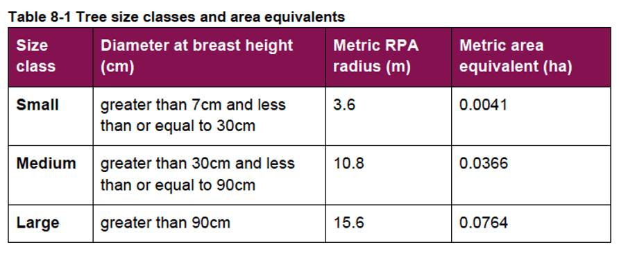
8.3.1. The broad habitat type ‘Individual trees’ may be used where a tree (or a group of trees) over 7.5 cm in diameter at breast height (DBH) does not meet or contribute towards the definition of another broad habitat type.
8.3.2. Individual trees should not be recorded separately where they occur within habitat types characterised by the presence of trees, such as orchards, lines of trees or wood-pasture and parkland, but can be recorded where they do not form part of a primary habitat description.
8.3.3. Ancient and veteran trees are irreplaceable habitats and the broad habitat ‘Individual trees’ must not be used to record these.
Even though all irreplaceable habitats fall outside BNG 4.0, they should still be recorded in the metric calculation. A special form for this has been built into the calculator and special rules apply.
Note: Paragraph 8.3.1 refers to trees ‘over 7.5 cm in diameter’ but table 8-1 below refers to trees that are ‘greater than 7 cm’. BS5837:2012 requires all trees 75 mm or over to be surveyed – at paragraph 4.2.4.
Broad habitat type Individual trees can be in either ‘urban’ or ‘rural’ habitats:
8.3.4. Individual trees may be classed as ‘urban’ or ‘rural’. Typically, urban trees will be bound by (or near) hardstanding and rural trees are likely to be found in open countryside. The assessor should consider the degree of ‘urbanisation’ of habitats around the tree and assign the best fit for the location.
8.3.5. Individual trees may also be found in groups or stands (with overlapping canopies) within and around the perimeter of urban land. This includes those along urban streets, highways, railways and canals, and also former field boundary trees incorporated into developments. For example, if groups of trees within the urban environment do not match the descriptions for woodland, they may be assessed as a block of individual urban trees.
Either way, they have the same Medium habitat distinctiveness, so the difference is perhaps academic.
Developers may seek to argue that some urban trees in groups or blocks are a woodland habitat or a ‘Hedgerow – line of trees’ habitat and not Individual trees habitat. BNG 4.0 and earlier versions use a different approach to calculating their habitat sizes. This approach is based on canopy area for woodland habitats and a linear measurement for ‘Hedgerow – line of trees’ habitats. However, it is the degree of ‘urbanisation’ that is key.
Trees in private gardens
Individual trees habitats within private gardens are also to be recorded in the baseline calculation, but should not form part of the post-development BNG calculation:
8.3.6. Established trees within gardens should be recorded in a site baseline.
8.3.7. Where private gardens are created, any tree planting within the created garden should not be included within post-development sheets of the metric. The habitat type ‘Urban – Vegetated garden’ should be used.
This is an important distinction and means we should be alive to any attempt to include newly created habitat in private gardens into post-development BNG calculations. The logic is that, as private space is outside the control of the developer, any post-development habitat management obligations they have cannot be applied to these spaces, and so should be excluded from the post-development calculation.
Measuring Individual trees habitat size
Habitat size is one of the key parameters used for calculating a habitat’s value – called Habitat Units (HUs). For baseline area habitats, the formula is based on four parameters:
HU = Area in hectares x Distinctiveness x Condition x Strategic significance.
Note: For linear habitats, length in kilometres is used instead of area.
The way BNG 4.0 measures the habitat area of Individual trees has reverted to the methodology used in BNG 3.0 but, thankfully, now uses a table that works!
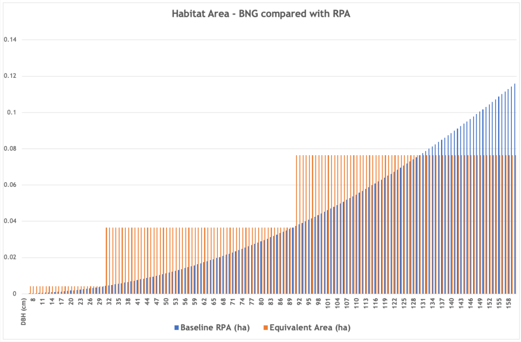
The effect is far more generous than the one used in BNG 3.1 as it values all the trees in the bottom two categories, Small & Medium, at the top of their range. All Large category trees are given the same habitat value as a tree with a stem diameter (called DBH – diameter at breast height) of 130 cm. [4] Given that the vast majority of urban trees fall within this range – with DBHs of between 7cm and 130 cm – this has the effect of greatly enhancing their habitat value.
The following graph illustrates the effect on a range of DBHs from 7 cm to 160 cm; RPA refers to root protection area and the orange stepped lines are the BNG 4.0 habitat area values assigned to each DBH. [5]
This difference is significant. For example, in a recent application we were involved with, trees on the site that had a baseline Urban tree habitat area of 0.7056 ha using BNG 3.1 now have an Individual trees habitat area of 3.1137 ha when the BNG 4.0 methodology is applied. This makes their habitat unit value much greater than it was before.
Here is the BNG 4.0 Individual trees habitat area measurement methodology:
8.3.8. Once the size, number and condition of trees is known, assessors should generate an area equivalent value using the ‘Tree helper’ within the metric tool ‘Main menu’ (Figure 8-2). The ‘area equivalent’ is used to represent the area of Individual trees. This value is a representation of canopy biomass, and is based on the root protection area formula, derived from BS 5837:2012.
8.3.9. Table 8-1 sets out class sizes of trees and their area equivalent. For multi-stemmed trees the DBH of the largest stem in the cluster should be used to determine size class.
Note: The correct metric equivalent area of Large category trees is 0.0765, not 0.0764.
This same approach applies to Individual trees habitats in groups or blocks:
8.3.12. Assessors should account for the size class (Table 8-1) of each Individual trees within a group or block. The number of Individual trees present within a group or block should be entered into the tree helper to calculate area equivalent. Do not reduce any area generated by the tree helper even if tree canopies overlap.
Assessing baseline Individual trees habitat condition
As ‘condition’ is one of the parameters used for calculating the habitat’s value, each Individual trees habitat tree, group or block needs to be assessed against the following criteria. [6]
Condition Assessment Criteria
A
The tree is a native species (or at least 70% within the block are native species).
B
The tree canopy is predominantly continuous, with gaps in canopy cover making up <10% of total area and no individual gap being >5 m wide (Individual trees automatically pass this criterion).
C
The tree is mature (or more than 50% within the block are mature).
D
There is little or no evidence of an adverse impact on tree health by human activities (such as vandalism, herbicide or detrimental agricultural activity). And there is no current regular pruning regime, so the trees retain >75% of expected canopy for their age range and height.
E
Natural ecological niches for vertebrates and invertebrates are present, such as presence of deadwood, cavities, ivy or loose bark.
F
More than 20% of the tree canopy area is oversailing vegetation beneath.
Number of criteria passed
Condition Assessment Result (out of 6 criteria)
Condition Assessment Score
Passes 5 or 6 criteria
Good (3)
Passes 3 or 4 criteria
Moderate (2)
Passes 2 or fewer criteria
Poor (1)
Note that ‘Fairly Good and Fairly Poor’ condition categories are not available for this broad habitat type.
In our experience, very few Individual Urban tree habitats will ever be assessed as in ‘Good’ condition and many will only ever achieve a ‘Poor’ score. Many urban trees are not native, [7] few survive to become mature, most are subject to some form of management or show ‘evidence of an adverse impact on tree health by human activities’, and most trees in a public space will never be allowed to develop ‘natural ecological niches’ as these often also present a public safety risk.
The same challenges will also apply when attempting to assess the future condition of post-development Individual Urban tree habitats after 30 years have passed (we discuss this below). In our view, every such tree should always be assessed as having a ‘Poor’ outcome given the uncertainties they face.
Assessing baseline Individual trees habitat strategic significance
Strategic significance is the fourth parameter used in calculating HUs. There are three categories – High, Medium and Low:
To qualify as ‘High’, the following evidence needs to be available:
5.4.3. Assessors must provide evidence by referencing relevant documents. If published, the relevant strategy is the Local Nature Recovery Strategy (LNRS). If an LNRS has not been published, the relevant consenting body or planning authority may specify alternative plans, policies or strategies to use.
5.4.4. Alternative plans, policies or strategies must specify suitable locations for habitat retention, habitat creation and or enhancements, and might, for example, be:
Local Plans and Neighbourhood Plans
Local Planning Authority Local Ecological Networks
Tree Strategies
Area of Outstanding Natural Beauty Management Plans
Biodiversity Action Plans
Species and protected sites conservation strategies
Woodland strategies
Green Infrastructure Strategies
River Basin Management Plans
Catchment Plans and Catchment Planning Systems
Shoreline management plans
Estuary Strategies
5.4.5. If no alternative is specified, agreement should be sought from the consenting body or Local Planning Authority when determining strategic significance.
In many cases, the proposed development site will fall within one of the criteria above (especially where the authority has adopted a well-designed tree strategy) and so should be given ‘High’ strategic significance.
If it does not then, given that trees nearly always provide ‘a linkage between other strategic locations’, we suggest that Individual trees habitats should always be assigned ‘Medium’ strategic significance.
It is notable that the Medium strategic significance dropdown option in the Metric calculator is still labelled ‘Location ecologically desirable but not in local strategy’. This suggests a wider definition than is perhaps suggested above.
Post-development Individual trees habitat creation.
Post-development Individual trees habitat creation also uses the same parameters for the HU calculation discussed above, but with a time-to-target factor added. This is the time it will take the new habitat to reach its target condition. If the created Individual trees habitat condition will be Poor, the time-to-target period is ten years, if it will be Medium, it is 27 years, and if it will be Good, it will be 30+ years.
These periods can be increased or reduced in yearly increments if, somehow, habitat creation has been advanced or delayed.
These are then factored into the calculation to allow for the future habitat created using the 3.5% discount tables – so x 0.700 for ten years, x 0.382 for 27 years and x 0.320 for 30+ years.
The calculation also assesses the difficulty of creating the target habitat. For Individual trees habitats, this is pre-set to Low (score 1), so does not affect the eventual calculation.
Existing habitats can also be enhanced on or off site or created off site. We do not discuss this here.
Post-development Individual trees habitat area forecasting
This assumes that any new tree planted will grow into a Small category tree at the end of the ‘project timeframe’. This is likely to be 30 years by default, as per Part 1 s.9 of Schedule 14 of the 2021 Environment Act. [8] This is the approach advised in the Guide:
8.3.13. Size classes for newly planted trees should be classified by a projected size relevant to the project timeframe.
most newly planted street trees should be categorised as ‘small’
evidence is required to justify the input of larger size classes.
8.3.14. When estimating the size of planted trees, consideration should be given to growth rate, which is determined by a wide range of factors, including tree vigour, geography, soil conditions, sunlight, precipitation levels and temperature.
8.3.15. Do not record natural size increases of pre-existing baseline trees within post-development calculations.
If a larger Individual trees habitat area projection is advanced, this will need to be justified.
The evidence of tree growth rates is patchy at best – see the About section in our Tree Canopy Prediction tool. To overcome this, we have adopted the simple rule-of-thumb approach commonly used by arboriculturists and assume that a tree’s girth grows by one inch (2.54 cm) a year. We then apply this to the standard tree sizes adopted in BS 3961-1 – Nursery Stock Specification to Trees and Shrubs [9] to calculate the eventual size of a tree 30 years after it has been planted. In all cases, save for semi-mature trees, the tree will be a BNG 4.0 Small category tree.
Here is the model we use:
The age of the tree being planted should not be ‘credited’ when calculating the time-to-target period. Sadly, BNG 4.0 does not take account of mortality rates, which are high for urban trees.
The Trading Rules
Individual trees habitats are given Medium distinctiveness in BNG 4.0 and so are subject to the Rule 3 Trading Rules:
3.2.1. Rule 3 is automatically applied by the metric and sets minimum habitat creation and enhancement requirements to compensate for specific habitat losses (up to the point of no net loss). These requirements are based on habitat type and distinctiveness, as set out in Table 3-2 (below).
In effect, any habitat losses may not be traded down. In this case, the broad habitat category is Individual trees. Given that there are very few habitats with high or very high distinctiveness that are likely to be either applicable or feasible, this will mean that Individual trees habitats will mostly need to be replaced like-for-like.
In our view, urban trees are too important to be substituted by any other, non-tree habitat.
The effect of these rules is that, not only will the proposed project have to achieve at least 10% biodiversity net gain when the Environment Act 2021 takes effect later in 2023, it will also need to comply with the Trading Rules. In some cases, this will mean that far more than the minimum 10% net gain will need to be achieved.
We look forward with interest to seeing how developers will ‘manage’ this new metric.
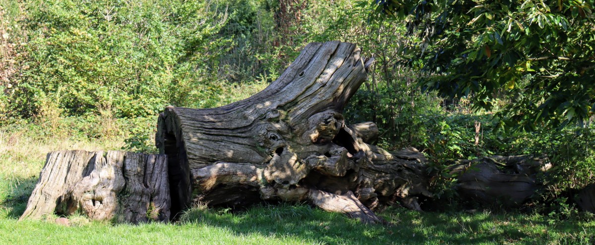
It was once believed that when a tree died, it was no longer of use. For decades, we have actively removed trees at the first signs of rot or fungal attack, felling them at the base and removing all evidence of their existence…
Our guest editor, Nick Gates, Naturalist, writes
Storm damaged trees are hastily sectioned for firewood or bio-fuel. Sometimes, we replace them with a new, younger version of themselves. It was thought that this in turn kept other trees healthy, and that the wider environment benefited as a result.
The fall of a tree opens up new opportunities…
But nothing is further from the truth. By removing this deadwood, we are stripping out a most vital layer of the natural world. Because when a tree dies, it isn’t actually dead.
As a tree grows, its core begins to die. Have you ever looked at a majestic old oak, its core completely hollowed out, and wondered how on earth it was still producing green leaves and fresh shoots? The reason is that only the outer layers of the wood, just below the bark, are alive. They transport all the water and nutrients that a tree needs to survive. Simultaneously, under the soil, a massive network of fungi around its roots help the tree collect all of the vital nutrients and minerals it needs. As the tree grows, the wood core, the growth rings left behind and superseded from previous season, slowly dies.
Left to fade away…
Over time, this core wood is slowly broken down by fungi. In the very oldest trees, the core is lost completely. Perhaps the most famous of these wood-feeding specialists is one you may well have eaten, the Shiitake mushroom. The fungi in turn are eaten by many species, from bacteria to nematodes, insects to mammals, whilst the rotten wood supports many more. Therefore, this soft rotting deadwood actually hosts a complex living food web.
An oak tree supports over 350 different varieties of insect. But over half of these feed on dead parts of the oak tree. Bats rely on deadwood cavities to roost, whilst feeding on many species of night-flying beetle that feed solely on deadwood. Redstarts require hidden cavities to nest, whilst searching for bark beetles and moths that grew up in the deadwood. Everything from blue tits to woodpeckers and wood mice to tawny owls rely on deadwood for some part of their existence. By the time an old tree falls completely, upended from its rotting root network, the wood may be dead but the vast diversity of creatures it is feeding are very much alive.
When we strip out deadwood from a natural environment, often under an aesthetic tidiness premise, we aren’t just taking the wood away. We are slowly eroding the complex living food web that the deadwood feeds. The Bristol Downs has suffered from this for many years. We could have hedgehogs snaffling snails from deadwood retreats and spotted flycatchers nesting amongst the craggy cavities in gnarled out stumps. Animals just need food and shelter to thrive. By removing deadwood, we take away both. There are many ways of leaving deadwood that look aesthetic whilst appreciating the enormous ecosystem service it provides. Good signage can help explain this.
In a time of unprecedented ecological collapse, we must all do what we can to help the natural world. Leaving deadwood in situ is one of the easiest ways to do this. So please, next time you see a fallen tree, don’t look on it as an untidy addition to the landscape, but enjoy it as the next opportunity for nature to reclaim a part in our everyday lives.
As you are aware, we have been expressing our continuing concerns about the welfare of the trees growing at Stoke Lodge Park and Playing Fields for the best part of a year now.
At the moment, our particular concerns are threefold:
The potential for damage to trees caused by pedestrians being obliged to pass over their root zones and under their canopies since Cotham School erected its boundary fence last year.
The potential for damage being caused to the trees growing within the new fence being caused by the school’s grass mowing regime.
The potential for damage to trees caused by vehicles passing over their root zones and under their canopies.
To a large extend, our concerns about issue three may have been allayed by the school’s adoption of a new access point at the eastern end of the fields, but we will have to see how this develops.
The new vehicle access point at the eastern end.
As for the other two issues, we attach images showing how the very muddy and disturbed path running around the outside of the school’s fence is causing disruption to the root zones of a number of trees – these are not all the trees being affected by this.
The eastern end of the fields.
The path leading to the Pavilion on the northern boundary.
created by dji camera
The path leading to the Pavilion.
These images show how the current mowing regime encroaches within the root zone of one of the Turkey oaks inside the fence.
The Turkey growing at the eastern end of the playing fields seen from above.
The Turkey growing at the eastern end of the playing fields – the mowing line is clearly visible.
Here is a video which shows the mowing issue more clearly.
In our view, something needs to be done about this before any damage being caused becomes irreversible.
Can you advise me what action the Council plans to take to protect these trees, please?
There are some 166 educational sites and 63 playing fields across the city. Together they cover over 560 hectares and form a significant proportion and an important part of the city’s open, green spaces.
This is the Part I of a two-part blog – here is Part II.
Despite this, Bristol City Council no longer manages trees growing on many of these sites and their related playing fields. We are not certain, but we imagine that this situation has come about as a result of the decline in local authority control over state educational provision with the rise of independent Academies.
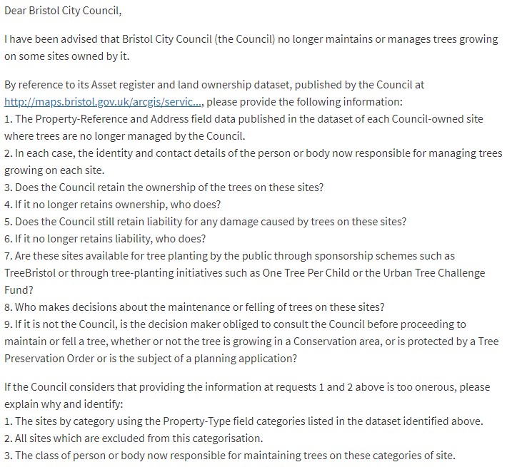
We issued a Freedom of Information request (FoI) to try to find out which sites remain under the control of the Council, but our request has been refused on the grounds that answering it would impose a significant burden on the council. Our more generic request at the end has also been refused on the same grounds.
The trees at Stoke Lodge Playing Fields
Recent events at Stoke Lodge and the playing fields there perhaps best illustrate our concerns and the potential threats to the many trees growing on land set aside for educational purposes.
The site was leased for 125 years to Cotham School in August 2011. Interestingly, the Council agreed to retain its responsibility for all the trees growing on the site. It also agreed to indemnify the school for any damage the school might cause to the trees and to insure against this risk.
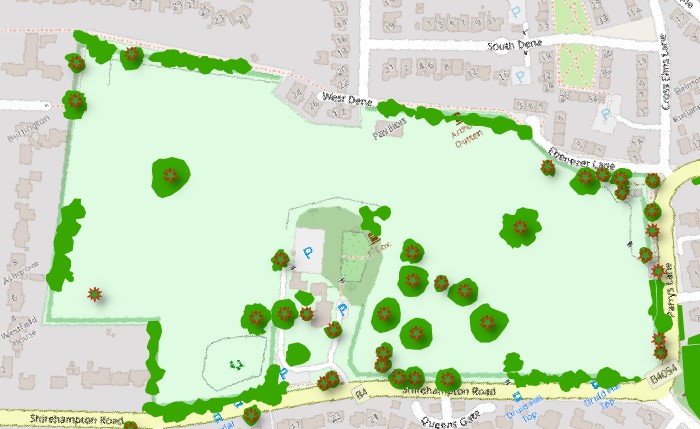
Stoke Lodge Playing Fields are located to the west of the city in Stoke Bishop ward and cover some 8.7 hectares of open space. Historically they were part of the grade II listed lodge (now an adult learning centre) of the same name which covers about two more hectares and contains an arboretum of important trees (the survivors of a collection that formerly spread right across the historic lodge grounds).
Unlike most of the land around it, this part of Stoke Bishop is not in a Conservation Area. For some 70 years, the whole estate, which until recently had never been seen as a divided space, has been used by the local community and is designated an important open space. Nearly all the trees on the Stoke Lodge estate are subject to Tree Preservation Orders (TPO) which were placed on the trees in early 2012.
The TPO trees and canopies
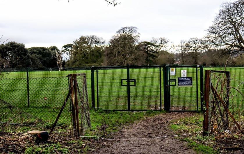
In the summer of 2018 Cotham School announced that it intended to erect a fence along the boundary of its leased land. They stated that they did not require prior planning permission to do so because they were exercising their statutory Permitted Development rights. After an initial dispute about whether the school could indeed use Permitted Development rights, in January 2019 work began to erect the fence.
It was at this point that the Bristol Tree Forum became involved after it became clear that the proposed route of the fence would pass through the root zones of a large number of important trees, many of which were the subject of a TPO.
The original plan – the fence passing through the root zones of many protected trees.
There then followed a protracted period of back and forth representations while we and the local community fought to get the fence relocated to avoid damaging the trees. This was partly successful. Where it was not, we were able to insist that the methodology for erecting the fence where it still passed through tree roots was modified to minimise damage. Even so, it took the constant vigilance of the local community and BTF representatives to ensure that Cotham School did not ignore the conditions placed upon it.
Setting aside the issue of the siting of the fence, our primary argument has always been that TPO law requires a prior planning application to be made (and approved) before any work is undertaken that could cause damage to TPO trees. Initially, the Council rejected this argument, effectively stating the Permitted Development rights trump primary TPO legislation. It also argued that, anyway, it could not proactively prevent damage to TPO trees, but had to wait until the damage has been done, which is, frankly, absurd. We continued to challenge these interpretations and, eventually, the Council conceded our points, though only after the fencing had been completed.
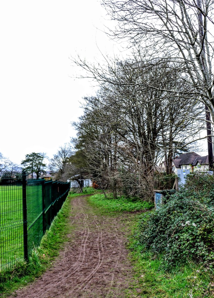
Things then appeared to return to normal,except that the community was now largely confined the unfenced areas around the boundaries of the site. As a result, the trees around the boundary are being exposed to heavier traffic through their root zones. We are concerned that this may have a long-term, adverse impact on their health.
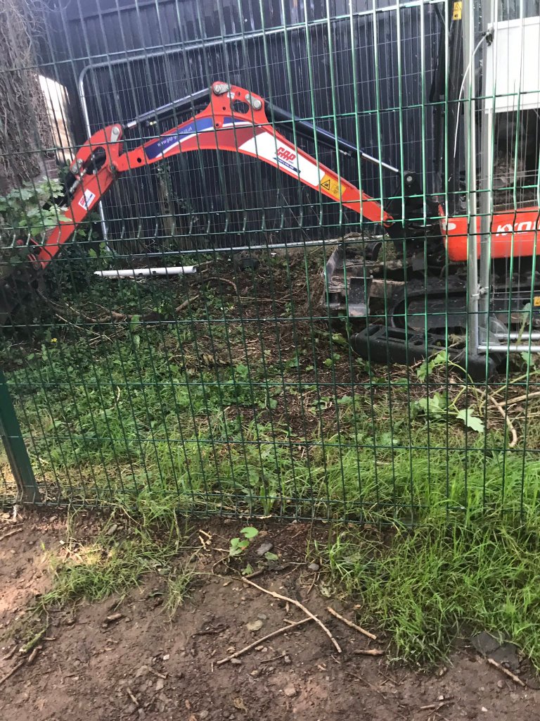
Then, in August of this year, and without any warning, contractors arrived to lay cable ducting across the site so that video surveillance equipment could be installed. Using a mini digger they immediately set about driving over and cutting through the root zone of a TPO Common Ash growing on the boundary of the site. Other non-TPO trees (some privately owned) were similarly damaged.
We lodged a complaint with the Council’s Planning department. As a result, enforcement proceedings were commenced and the school, whilst narrowly avoiding prosecution, was obliged to take remedial action to try to mitigate the damage caused to the tree. The council also felt obliged to remind the school of its obligations to TPO trees:
And this is a site where the trees are still under the ‘guardianship’ of the Council! What about those sites where the care is vested with the school?
Our concerns remain for the future health of those trees whose root areas had been invaded by the fence installation. We have also continued to express fears about other continuing threats to the trees arising as a result of other activities on the site. So far, our concerns have been ignored.
For example, continuing root compaction and branch damage is being caused to the Persian walnut growing by the gate close to the rear car park and to the trees growing beside the Parrys Lane entrance. This is the result of grass mowers and other service vehicles using these entrances to gain access to the site. We are told the access point has been moved to the Parrys Lane entrance, though that too involves vehicles passing over tree roots.
Driving over the walnut’s roots on the way to mow the playing fields
Historically, it looks like vehicles accessed the site from behind the Children’s Play Ground on the southwest of the site, so did not need to drive over any tree roots. The presence of the fence and lack of any gate there has now closed off that option.
The school’s contractors also continue to mow within the root zones of the two large Turkey oaks (BCC-77025 on the eastern end & BCC-77059 on the western end) that grow inside the playing fields fence.
The eastern Turkey oak
However, the Council and the school decline to address these issues saying that they have made adequate arrangements to safeguard the trees.
STOP PRESS – 4th January 2020 – since writing this blog, Cotham School has felled a TPO protected Elder (plus five others) on the Eastern side of the playing fields and poisoned it with Glyphosate. We have informed Bristol Council Parks and Planning Departments and asked them to investigate. They advise:
“The felled Elder trees were not included within or protected by the TPO covering the adjacent Sycamore tree.
It is very unlikely that roots from the Elder trees will have grafted with the roots from the Sycamore tree. Also translocation of herbicide between grafted roots is very unlikely.*
We are not aware of any plans to fell the twin stemmed Oak beside the white shed at the eastern end of Stoke Lodge Playing fields.”
But, when we asked Parks if these works were done with their prior knowledge and agreement, or if the department had approved the application of Glyphosate to the tree roots, or if they had seen the School’s Aboricultural Management Scheme, they answered ‘No’.
It seems that the school had complied with their obligation to get consent from the Council, their Landlord, but that the Council’s Education Asset Management team had failed to consult Park’s specialist tree officers about the plans.
Cotham School has issued these FAQs – 33 to 38 in response to this issue.
The fate of other educational sites
In the meantime, we have no idea if or how other schools are managing the trees on their sites, or if the Council is consulted when they do.
Even though, in most cases, educational sites are still on Council-owned land, the Council only needs to be told if the trees have a TPO or are growing in one of the city’s 33 conservation zones (or, we assume, if the Council’s lease with the school keeps the management of the trees in the control of the Council – as was the case at Stoke Lodge).
Given that Bristol City Council does not normally issue TPOs for trees on its own land, arguing that it is a good landlord and will look after important trees appropriately, it is unlikely that trees that have been handed over on other educational sites will have been protected by a TPO. Perhaps the council should now review its policy where it no longer manages trees growing on educational sites in light of this history.
Certainly it seems that new tree planting need no longer involve the Council. For example we recently observed that several newly planted trees at Cotham School’s main site had died. It was only when we noted that the dead trees were missing from the Council’s tree stock data for the school that we learned that they were no longer responsible for the trees on the site. We have now been told by the school that the trees were planted as part of a recent development and that the failure of these dead trees will be ‘rectified’ soon. Meanwhile, it seems that these new trees are no longer selected, managed or mapped as part of the Council’s wider tree stock strategies and that the existing trees on the site are no longer the Council’s concern.
Presumably, similar arrangements are happening across the city with other educational sites being left to make their own, ad hoc arrangements to plant trees or not. Given that the One City Plan aims to double tree canopy cover over the next 25 years, it seems a great shame that this important land bank of possible new planting sites might have been excluded from helping to achieve Bristol’s plans.
We are also concerned that school governors (quite apart from lacking the necessary skills to manage the trees growing on their sites) may not yet have realised the full implications of the practical and strategic obligations that taking on such an important part of Bristol’s tree stock places upon them. As a result, they are likely to have to buy in (at our expense) ad hoc expertise, thereby possibly overlooking the wider strategic considerations that are needed when it comes to managing trees across the city.
This, coupled with the distinct possibility that well-meaning but unqualified Council officers may be making critical decisions about the welfare of trees on educational sites, makes for a very worrying situation.
We have now received an explanation, via a local Councillor, for why the trees on Redland Hill were felled – see our recent blog – Redland Hill street trees felled by the Council. Why?As we are anxious to update the record as soon as possible, we have decided to make it public. Here it is, received just yesterday:
“Contractors removed some of those trees along this strip in error. The contractor is planting replacements free of charge (hence the blue markers) [small posts painted blue, which we noticed had recently been inserted in a line along the wall – just visible in the image below].
The history I’m told goes as follows:
The tree officer selected and marked the specific trees to be removed with a green paint spot. The thinning out was necessary due to the lack of space on the narrow strip of verge. It is good arboricultural practice. It has been suggested this row used to be part of an old beech hedge, this isn’t the case because the trees removed were a mix of species, ash, sycamore and elder.
Unfortunately other trees, without the green spots and which were scheduled to remain, had previously been marked up with orange paint spots. It was made clear to the contractor’s manager when they met the Council’s tree officer on site which trees were to be removed and which should stay.
The contractor’s team leader who subsequently carried out the felling work had not been given the full information from the manager and felled all the trees except the large Beech on the corner. The felling was also done much quicker than expected which is why the Councillors weren’t notified in advance thus compounding the error.
[The Trees and Allotments Manager] has discussed this communication error with the contractors and they have agreed to replace the trees that were incorrectly felled (i.e. the orange spot ones). The new replacement trees will be much better suited to the location than the original species. The new trees are birch with a very narrow and upright form. This will be much more suited to the narrow planting location and should have potentially less conflict in the future with pedestrians with pushchairs and will be easier to maintain next to the highway. They will all be planted by the end of tomorrow.”
Here they are…just planted…and we are very pleased to see them.
The view after planting – 13 birch planted in six groups
We have asked the Council to comment. We await their response, though we see that they have already commented to BristolLive.
Councillor Clive Stevens (and ex-Chair of Bristol Tree Forum) commented: “Although conspiracy theories are more fun to read about, sometimes it is due to a good old fashioned cock-up. Lessons to be learned on communication with the public which I think was the main theme of the Tree Forum’s original blog is the need for more and better consultation. That applies to many things the Council does. If the Government decided to increase the duty to consult on tree works lets hope they provide some extra money to pay for someone to do it. And secondly, often the Council takes a while to respond and in this case probably because they wanted to finalise the solution first; its the same department dealing with Stoke Lodge and ex Wyevale Garden Centre situations and probably a hundred or so other active planning applications all with tight deadlines which take priority.”
As a precaution, we have asked the Council to take urgent steps to protect the last remaining beech tree on the boundary wall with a Tree Preservation Order. This is partly because of what has happened, but also because we have had to advise the Planning Department that someone on the site has dumped a large amount of builders rubble and other materials on the tree’s roots on the other side of the wall from the tree. Clearly this important tree (the last vestige of a historic hedge which probably predates both the wall and the buildings nearby) is still under threat and needs protection.
We are sad to have lost what was once a significant aspect of one of the approaches to the Downs, but are pleased to see the whole sorry saga resolved. We hope that lessons have been learned and look forward to watching the replacement birches grow and flourish.
Until a few weeks ago there was a lovely informal stand of trees along Redland Hill, which is a busy road that I walk up twice a day to get to the Downs.
As it used to look – Google Street View – July 2018
Rush hour stationary traffic belches out pollution and the trees provided some respite. I have watched over the years as several of the old beech trees were removed. They were probably once part of a beech hedge that predates the existing buildings (and the wall): now only one is left. Instead, an informal collection of ash and other trees grew in their place. This was a great place to see Broomrape, a parasitic plant that grew at the base of some trees.
How it now looks…All gone – just one lonely beech and some street furniture left to improve the view.
There was no consultation of any kind with the community. One day the trees were there, the next they were gone. Without any involvement from the Bristol Tree Forum, the local councillor or the local community, we can only guess why the trees were removed. Perhaps it was concerns about the nearby wall. A careful examination shows that there are no obvious cracks, even close to the one remaining beech tree. Was a proper engineer’s survey done? In days gone by a Bristol City Council Tree Officer defended a tree, similarly close to a garden wall, that the owners wanted to cut down, even obtaining an engineer’s report. Even if there were substantial damage to the wall, other options were possible, such as thinning out the trees (only some were marked with green paint) or laying them as a hedge as was recently done in Redland Green.
…just sawdust, rubbish and some ivy (now hacked down), nothing else.
Of course the removal may be for a different reason. Maybe what the developers really wanted to do was to create views for their flats and successfully put pressure on the council? Perhaps the pavement will be widened? Or perhaps the area will be dug up for services. I don’t think the removal of trees was in the planning application.
J
At this time, with the threat of Ash die-back disease we should be looking to keep healthy ash trees in case by chance they turn out to be the ones that are resistant. Cutting down healthy ash trees is misguided.
The money that was spent cutting down these trees should have been used for planting new street trees, something that Bristol City Council says it has no funds to do. I’m guessing more money will now be spent to tarmac over the area where the trees once were.
Bristol City Council should have thought differently. For example, it should have enforced a root protection area for the last remaining beech tree. This was apparently not done and I guess we will see that last tree fail in the next ten years.
At present, Bristol City Council refuses to consult over tree felling decisions, despite requests from the Bristol Tree Forum for a decade. It is almost as though the council thinks there are no inhabitants in the urban forest and that they always know best. Unilateral decisions such as this show how important the government’s proposal is to require local authorities to properly consult before removing street trees.
Bristol has an ambitious plan to double its tree canopy by 2050. Yet all over Bristol, on an almost daily basis, tree canopy is being lost – for multiple reasons. Just in the local area, about half a dozen really large trees have gone and the canopy cover has decreased. We did manage to get one new street tree, in the middle of Redland roundabout but it took a four year battle and the help of our local MP to get it planted. Trees are lost very gradually in our bit of Bristol and are often not replaced. So the change in canopy is not obvious. Fisheries biologists have coined the term “shifting baselines”, where each generation sees only minor negative changes. But the effect over a long period is substantial.
As Professor Corinne Le Quere has said, “actions to tackle climate change have to penetrate all the decisions that we take in society”. We are hoping that we can get this point across to the decision makers in Bristol City Council.
The Bristol Tree Forum will now be campaigning for these trees to be replaced.
We are delighted to announce that the winner of the inaugural Bristol Tree Forum’s Tree of the Year competition is the Lucombe Oak, submitted by the community group We Love Stoke Lodge. The Lucombe Oak was a clear winner with 584 votes out of the 1,269 confirmed votes cast for the eleven entries.
We Love Stoke Lodge is an informal community group of local residents based around Stoke Lodge, a 26-acre park and recreational area in Stoke Bishop in the north-west of Bristol.
The group writes:
The Lucombe Oak is a cross between a Turkey Oak and a Cork Oak. It was first raised by an Exeter nurseryman, William Lucombe, in 1762. It is unusual in the fact that it keeps its leaves over winter. The story goes that William Lucombe was so attached to his special oak that he felled the original specimen to provide wood for his own coffin and kept the boards under his bed until he died. However, he lived an exceptionally long life, dying at the age of 102 years, by which time the planks had decayed in the Devon damp. To quote an article from Royal Botanical Gardens, Kew, this showed ‘that Lucombe knew more about growing trees than preserving them’. On his death timber from one of his early propagations was used to make his coffin instead.
Notwithstanding the tree’s fascinating history, so many of our community hold treasured memories of this tree dating back over four generations. At a recent community picnic those in their nineties sat alongside primary school children of today talking about the best picnics they have had under our beloved tree and sharing tips on how to climb it wonderful branches. This tree is the meeting point for many sports and well-being groups. Its branches shade baby groups, yoga classes, families and friends from the sun (and the rain) every day – as it has done for hundreds of years ! This tree is a not just located in the centre of our community, it is part of it.
This giant London plane tree that dominates an area of Brislington’s Nightingale Valley is, together with the nearby pack-horse bridge, one of the features that help define this unexpected green haven. Its trunk was once an open hollow, tempting the mischievous to light fires within it so a few years ago a local action group walled it up. This has given rise to a legend that a witch is entombed within. Many generations of Brislingtonians have picnicked in its shade, swung across the brook from ropes attached to its boughs or caught tiddlers beneath it. It has a symbolic significance: It’s tall, it’s strong, it’s seen adversity, it endures.
We would like to thank all those who submitted a nominee. We were delighted to receive such a varied and eclectic range of wonderful and inspiring trees, both living and dead. An inspiration for next year’s competition.
Our congratulations to the winner and the runner-up and thank you to all those who voted.
For more information about the competition and the votes cast for each entry, click on this link – Bristol Tree of the Year 2018.