WEMCA’s Local Nature Recovery Strategy (LNRS) will fail to provide Bristol with the benefits promised for nature. While the new Biodiversity Net Gain (BNG) rules require most development in the city to increase biodiversity by at least 10%, unfortunately the LNRS will not apply to most potential development sites.
The LNRS is a locally led and evidence-based strategy which aims to target action and nature investment where it’s most needed. We’re told that the strategy will also focus on biodiversity net gain by increasing the strategic significance of specific habitats. However, it is hard to imagine how the LNRS will help to enhance biodiversity net gain in most, if not all, potential development sites in the city.
We might have been better off, at least as far as the application of biodiversity net gain to new development is concerned, by asking the LPA to specify alternative documents (such as those listed at the end of this article) for assigning strategic significance instead.
The issue
When calculating the impact of a proposed development on biodiversity, one factor taken into account is the strategic significance of any habitat found on a focus area for nature recovery site (coloured purple in the map above). If strategically significant habitats are created or enhanced, then their strategic significance is set to High in the Statutory Metric calculator tool and a 15% uplift to the calculation of its value is applied. Subject to which of the six LNRS areas is being considered, these are the strategically significant habitats in the city:
Ditches
Ecologically valuable lines of trees
Ecologically valuable lines of trees – associated with bank or ditch
Grassland – Floodplain wetland mosaic and CFGM
Grassland – Lowland calcareous grassland
Grassland – Lowland meadows
Heathland and shrub – Mixed scrub
Heathland and shrub – Willow scrub
Individual urban or rural trees
Lakes – Ponds (priority habitat)
Priority habitat (on the River Avon and the Riparian buffers)
Species-rich native hedgerow with trees – associated with bank or ditch
Species-rich native hedgerow with trees
Species-rich native hedgerows – associated with bank or ditch
Species-rich native hedgerows
Urban – Open mosaic habitats on previously developed land
Urban – Biodiverse green roofs
Woodland and forest – Lowland beech and yew woodland
Woodland and forest – Lowland mixed deciduous woodland
Woodland and forest – Other woodland; broadleaved
Woodland and forest – Wood-pasture and parkland
However, a detailed examination of the LNRS map reveals that not all parks and green spaces have been designated as focus area for nature recovery sites. It’s only those which are in one or both of the following:
a location where they can make a greater contribution to ecological networks
deprived areas with a lack of access to nature.
These designations were based on Bristol’s previous work on ecological networks within the city and where wildlife-friendly interventions are most likely to be feasible. This means that the existence, creation or enhancement of these special habitats outside these areas will not attract the 15% strategic significance uplift.
The BNG requirements
The now compulsory Statutory Metric Guide, used for calculating Biodiversity Net Gain (BNG), advises (at page 27) that: ‘Strategic significance is the local significance of the habitat based on its location and habitat type. You should assess each individual habitat parcel, both at baseline and at post-intervention, for on-site and off-site.’
If the LPA has adopted an LNRS then only the High or Low strategic significance multipliers can be used (High – formally identified in local strategy = 1.15. Low – area compensation not in local strategy = 1). If it has not adopted an LNRS, then the Medium strategic significance multiplier may also be used (Location ecologically desirable but not in local strategy = 1.10).
Where an LPA has adopted an LNRS, all those sites which have not been identified as a focus area for nature recovery site will be designated as having Low strategic significance and so attract no uplift, even if they’ve been identified as important habitats in the Local Plan or in another strategic document adopted by the Council. These documents (used where an LPA has not adopted an LNRS) can include:
Draft Local Nature Recovery Strategies
Local Plans and Neighbourhood Plans
Local Planning Authority Local Ecological Networks
Parks and Green Spaces Strategies
Tree and Woodland Strategies
Area of Outstanding Natural Beauty Management Plans
Biodiversity Action Plans
Species conservation and protected sites strategies
Green Infrastructure Strategies
River Basin Management Plans
Catchment Plans and Catchment Planning Systems
Shoreline management plans
Estuary Strategies
Baseline habitats cannot be uplifted
Despite the BNG strategic significance guidance, Defra has stated that LNRS designations only apply to the creation or enhancement of post-development biodiversity mitigation habitats. They don’t apply if these habitats – called the baseline habitats – are found on the site before development begins.
This means that the 15% strategic significance uplift can only be applied where offsite biodiversity mitigation is being delivered in a focus area for nature recovery site. If these habitats are being delivered elsewhere, the uplift may not be applied.
However, even if the baseline habitats were included, it is unlikely to make any difference This is because the focus area for nature recovery sites identified in Bristol are, for the most part, located in public parks or green spaces, on river banks, in riparian buffers or on railway margins, none of which are likely ever to be developed or, in many cases, used to offset habitat lost to development elsewhere.
So far, no announcement has been made as to whether any of Bristol’s focus area for nature recovery sites will be made available for offsite habitat mitigation and the proposed new Local Plan does not commit to using these sites for this purpose.
This, combined with the challenge of finding LNRS suitable for offsite habitat mitigation, registering them as biodiversity gain sites and then managing them, effectively, in perpetuity, suggests that few feasible LNRS sites will be found, especially as many sites are also in demand for public access for recreation.
In a boost for the environment, new legislation now obliges most developers to set out how they will achieve at least 10% more biodiversity than already exists on their proposed development sites.
Developers must now show how they will improve the biodiversity of their development site as a result of their works. Developers must record the (baseline) on-site habitats that exist before development starts and show how they will either enhance or replace these on site. If their proposals fail to reach the 10% threshold, the developer may provide the shortfall elsewhere. This post-development mitigation should be done as closely as possible to the development site, or at least within the Local Authority. However, if this isn’t possible, they can use approved sites anywhere in England.
This approach is called the Biodiversity Gain Hierarchy (found in Schedule 7A of the Town and Country Planning Act 1990 at section 37A). The Hierarchy says it’s a priority to avoid the ‘adverse effects’ to ‘onsite habitat with a habitat distinctiveness score … equal to or higher than four.’ If this can’t be avoided, only then is mitigation permitted. In our experience, nearly all developers ignore the requirement to avoid adverse effects and move straight on to mitigation.
Since the introduction of the Bristol Tree Replacement Standard in 2013, developers (and planners) have ignored the policy requirement to avoid tree removal where at all possible. Instead, they’ve moved straight on to providing compensation for the trees lost to the development. As a result, the money set aside for replacement tree planting was not spent (on occasion reaching nearly £1 million) and many of the lost trees were never replaced.
Under the Hierarchy, habitats that score four are designated as having medium distinctiveness. While many habitats have medium distinctiveness, many don’t. For example, managed grassed areas (called ‘modified grassland’) are often found on urban sites but have a low distinctiveness score. So, too, do many other urban habitats such as allotments and gardens. Developers are not required to avoid harming these, though losses to these habitats must still be mitigated.
There’s no definition of what an ‘adverse effect’ is or any guidance on how it is assessed. However, recent advice from the Bristol’s Chief Planner about the meaning of ‘harm’ suggests that this could be interpreted very broadly or simply ignored because some sort of mitigation will always be available.
In the last extreme, developers may purchase biodiversity credits. We wait to see how this and the offsite biodiversity mitigation market evolves, but a 2012 paper published in the Harvard Environmental Law Review suggests that such environmental markets are prisoners of their own geography because the space available is always constrained:
Markets for water quality, biodiversity, endangered species, fisheries, air quality, and aquatic resources, to name a few, must recognize that the commodities they trade exist at particular geographic scales, and set appropriate spatial limits on the redistribution of environmental quality. The size of geographic trading areas has significant implications for the economic viability of markets and the ecological quality of their offsets.
This will be a particular challenge when providing biodiversity mitigation in urban areas.
The squeeze on green spaces
Land use in Bristol is subject to intense competition by many stakeholders. This is especially true for our green and open spaces, which offer many ‘services’ beyond just habitat provision. There is very little, if any, space available for new biodiversity to be created. At best, some green spaces might be enhanced, but opportunities to do this are likely to be very limited.
For example, Bristol Tree Forum’s examination of the three proposals to develop Bedminster Green shows that, if these proposals are allowed, then nearly 400 new trees will need to be planted to compensate for the lost tree habitat – a medium distinctiveness habitat. There’s no room to plant these trees on site, so offsite provision will be needed. There are very few opportunities for doing any new tree planting (as opposed to replacing lost trees) in the surrounding wards or even across Bristol, let alone, as is usually required, within a mile of a development site.
Instead, these replacement trees will have to be planted somewhere else: ‘in some foreign field that is forever Bristol’. This will inevitably lead to a net loss of biodiversity across the city as nature is ‘hollowed out’. This is unacceptable. The whole purpose of the new biodiversity gain regime is to improve overall local biodiversity, but it seems inevitable that Bristol will instead see a steady, inexorable decline.
We are disappointed that the current draft of the new Local Plan addresses none of these issues and have said so in our responses to the latest consultation:
The new Biodiversity Net Gain (BNG) obligations, which came into force last February, aim to improve our natural environment by requiring that all new developments have a positive impact (a net gain of at least 10%) on biodiversity.
For this reason, we believe that Bristol urgently needs to follow the lead of the other west of England councils, B&NES, South Gloucestershire and North Somerset, and adopt a Biodiversity Net Gain Supplementary Planning Document (SPD). A list of other local authorities that have adopted their own biodiversity SPDs can be seen here on the Local Government Association planning advisory service website – Biodiversity Net Gain in Local Plans and Strategic Planning.
Councils are encouraged to develop a locally specific SPD as part of their Local Plan. This would:
set out local priorities and strategies that require developers to deliver BNG locally
ensure that BNG contributes to wider nature recovery plans such as the newly launched Local Nature Recovery Strategy (LNRS) and other local objectives, and help ensure that the right habitats are provided in the right places
link BNG requirements to other strategic objectives and place-making policies in the Local Plan, to ensure a more holistic approach
set requirements for managing and maintaining habitats provided through development.
Having such a document would clarify exactly what developers need to do in terms of the BNG requirements. While these requirements have many gaps, they are now, as it were, the only game in town and we must try to make the best of them. We believe that developing a robust BNG SPD could help mitigate these problems by adding tougher conditions that developers must meet.
With the launch of the LNRS – a collaborative effort to help people and organisations within WECA and North Somerset take effective action for nature – it has become more important than ever for Bristol City Council to bring this strategy into action, especially where new development is planned.
Two factors causing us the most concern (there are others) are the exclusion of stakeholders from the BNG decision process and the lack of enforcement of BNG requirements.
Consulting stakeholders
We’ve long been concerned that the new BNG regime excludes stakeholder groups such as ours from engaging with and commenting on the approval process for Biodiversity Gain Plans (BGPs) because of the way the planning rules work.
The BGPs are a post-approval requirement (see Schedule 7A of the TCPA ’90, Part 2, section 13(1)), which means there’s no obligation for a developer to demonstrate how it will meet its BNG responsibilities during the application stage (although the Council could require this).
Under current rules, BGPs only need to be submitted for approval to the Planning Authority after an application has been approved. However, there’s no statutory requirement to consult any statutory bodies on BGPs or to publicise or consult on the submission of a BGP prior to its approval. It seems, therefore, that we (and other stakeholders who, like us, are fighting for everyday nature) will have no say in what is proposed, or even have any idea of what a BGP contains or how it could affect us.
Surely this goes against the principles of open governance and localism which councillors should be fighting to defend, especially where it’s likely to have a direct impact on the very places that we Bristolians love and value?
Improving enforcement
As a recent article in Local Government Lawyer magazine points out, there are serious issues around BNG enforcement that need to be resolved.
We’ve been trying to engage with council officers over this issue for some time, but so far without success. Maybe the time has come for the Council to seize the initiative? With the proposed new Local Plan moving towards its public hearings stage early next year and the likelihood that the plan will be adopted next April, maybe now is the time for the reconstituted Local Plan Working Group to take this in hand.
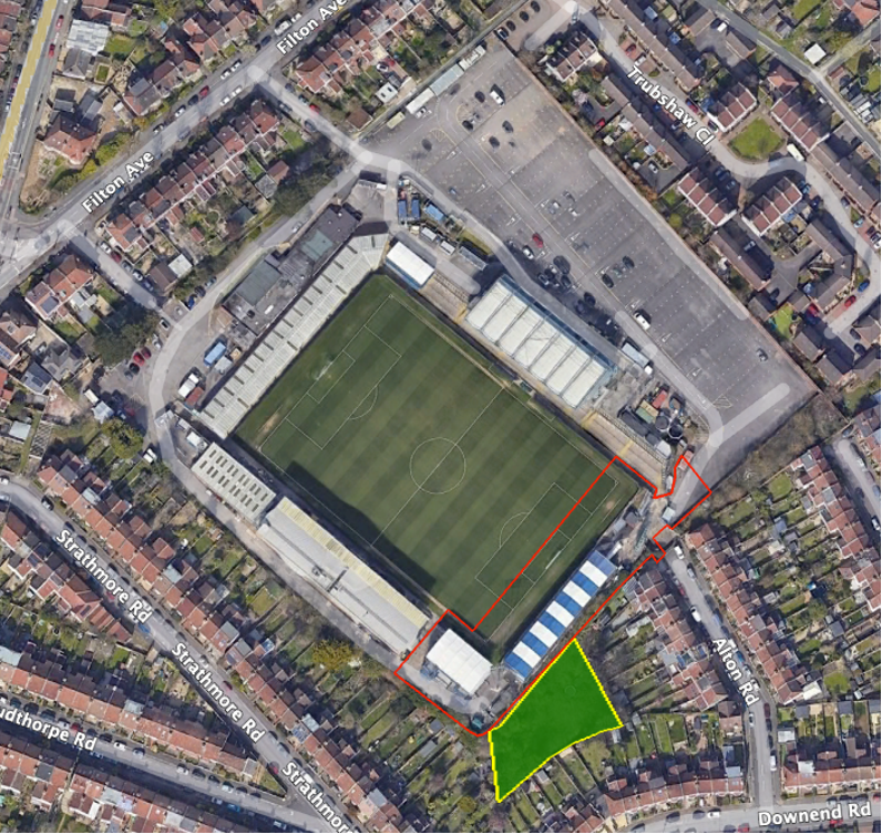
One of our fears is that some planning conditions, such as this one from the recent, pre 12 February 2024, Bristol Rovers Memorial Grounds application are unenforceable. In this case they only oblige the club to submit a proposed Landscape Ecological Management Plan (LEMP). They did this last June. However, the wording of the condition means that the club is not obliged to perfect this or even to carry it out.
Readers may recall that the development had been completed and the new stands occupied long before the main application was made, well before this and other conditions had been submitted or approved. In addition, as part of the eventual approval, the club agreed to plant a wood on a piece of unused land it owns to the south of the new stadium (the area shaded green below), but this has not yet been done.
As part of this agreement, the club is expected to enter into a LEMP to plant the wood and then maintain it in perpetuity. The LEMP Condition says:
Within 6 months of the date of consent, the applicant shall submit a 30-year Landscape and Ecological Management Plan (LEMP). This should address retained features of ecological interest, together with mitigation and enhancements to be provided. The LEMP should set out management compartments, objectives, and prescriptions for all new proposed soft landscaping/planting to demonstrate how all habitats will be managed to their target condition (as specified in the BNGA). It should also show how management of the site will be resourced and monitored.
In this example, all that can be enforced is a failure to submit the LEMP within six months, which, in this case, has been done. There is a S106 imposing LEMP obligations but this is toothless and, anyway, only the Council can enforce it – which it is not obliged to do.
There’s also the practical effect of the Biodiversity Gain Hierarchy – Biodiversity net gain Guidance Paragraph: 008 Reference ID: 74-008-20240214. This effectively means that the developer need not achieve any net gain on site, or even locally, but can instead deliver it anywhere in England or, as a last resort, simply buy BNG credits, though at a premium.
For example, the grant conditions – 11 (The BGP condition), 12 & 14 – in the recent, post-12 February Council application, The White Hall, Glencoyne Square, are unenforceable given their wording as there is only an obligation to submit; again, approval is not required. We assume that a s106 agreement and a Habitat Management and Monitoring Policy (HMMP) will need to be produced, but, at the moment, we still have no idea how the self-acknowledged 38.09% habitat loss will be mitigated, or where.
Given the intense competition for space in the city, it seems inevitable that, as a result of the application of the Biodiversity Gain Hierarchy, Bristol’s nature will, bit by bit, be exported to some far-off field that no one knows or cares about. In theory, a BNG SPD could at least try to ensure that habitats lost to development are replaced locally wherever possible.
It’s been suggested that new SPDs can’t be delivered until after the new Local Plan has been examined and formally adopted. Maybe, but we see no reason why we can’t at least start a conversation about this. As it is, the proposed Local Plan will need substantial redrafting to align with the new BNG rules, having been adopted by the Council before these had been finalised.
It’s also been suggested that there are neither the funds nor enough officer time available to develop this new SPD. However, since all the adjacent councils (members of WECA), and many farther afield, have developed, or are developing, their own SPDs, we can surely save time and expense by looking on these as templates from which to build our own. The examples above alone make it all the more urgent for issues such as this to be resolved with the early adoption of a BNG SPD. We urge the Council to commission officers to draft an SPD as a matter of urgency.
We urge the Bristol City Council Cabinet to reject the current draft. More nuanced rules, that meet identified real needs, need now to be developed following a proper consultation with Bristol’s allotmenteers. The PGSS must be also integrated into the new Local Plan so that all the sites that have been identified are protected either as Local Green Space or as Reserved Open Green Space and given proper planning weight when decisions about their future use and development are made.
We are particularly concerned that the draft rules relating to trees on allotments are too narrowly drawn and will result in the loss of allotment tenants’ ability to make the best use of the particular conditions of their plot. We urge the relaxation of these proposed limits on the number and types of trees which can be planted.
Food growing as part of the draft Parks and Green Spaces Strategy
We are concerned that the Strategy for Food Growing and Allotments has been included as Chapter 6 of the draft Parks and Green Spaces Strategy (PGSS). This is a departure from the 2008 PGSS, which makes it clear that such spaces are not included, since they are not public spaces: ‘The Strategy does not consider green spaces that are not freely accessible to the public, including allotments, city farms, school grounds, or Sites of Nature Conservation Interest in private ownership.’
The proposed PGSS recognises that: ‘There are other green spaces managed by the council that are not included because they do not offer full public access for recreation …’ [our underlining]. Given that allotments and other land used for growing food (including grazing land) are subject to private tenancies, with rental payments and mutual rights and obligations agreed between tenant and Council, it is hard to understand why they have been included in the strategy proposal.
We need to recognise the importance of this specific type of land use and ensure that it is not made an ancillary element in the PGSS. It deserves greater attention, which is why we suggest that it should have been integrated into and protected by the current proposals for the new Local Plan (as, indeed, Parks and Green Spaces should also be) rather than treated as an add-on to the proposed PGSS.
In particular, the current status of and strategy for market gardens, smallholdings and grazing land (and other land not used for food growing), which have an area greater than all current allotments combined, get only passing consideration. Little or no thought is given to the opportunities these sites present for nature recovery, biodiversity enhancement and other environmental gains.
Instead, we are told that these sites:
… have limited benefit beyond the individual users … and many smallholdings tend to use less than 10% of their site for food growing … we now need to review our current landholding agreements so that we can start to explore opportunities to repurpose land to diversify our food growing spaces and ensure land is being used effectively to meet Bristol’s food growing targets. … Once suitable land has been identified we will review how these opportunities are promoted to ensure that the system of securing land is fair and equitable. We are particularly interested in opportunities that will not only ensure land is being sustainably and efficiently managed but that also delivers social value and benefits the residents of Bristol.
In the face of the demand for allotments and the need to increase local food production, which has led at least in part to the proposed changes in the tenancy agreement, these areas must surely warrant greater protection than is given them in the proposed PGSS. These areas also contain many trees (often veterans) and other ecologically sensitive habitats, and many are in SNCIs. It is vital that these matters are properly considered when planning any change of use of such land. This ought to be addressed properly in the proposed new Local Plan, not in this draft strategy.
Trees on allotments
Trees on allotments fall into two categories: those within allotment plots and those on allotment sites but outside the plots.
Trees outside allotment plots
From our analysis of data on the Council’s Open Data site, we estimate that allotment sites total some 105 hectares when community orchards are included. However, only about 87 hectares of these sites are productive. This means that around 17% of allotments, some 18 hectares, are unproductive. We welcome the clarification in the new tenancy agreement that trees in these unproductive areas remain in the care of the Council and may not be damaged by tenants.
Trees within allotment plots
Proposed allotment Rule 4.0 Trees deals with trees growing within allotment plots. We distinguish between newly planted trees and existing trees below.
New trees
Regulation 4.4 limits the height of trees to 2.5 metres (a common constraint in other councils). The limit in Regulation 4.3 of one tree per allotment sized between band B and band C is far too restrictive, particularly since the majority of plots fall within these bands.
Rule 3.1 requires that the tenant uses at least 75% of the plot for ‘a cultivated crop of vegetables, fruit bushes [not fruit trees], ornamental flowers, and herbs.’
Rule 3.3 states that fruit trees will occupy the non-cultivated area of the plot (which may be no more than 25% of the plot) unless they are underplanted with a productive crop, in which case they will be counted as being part of the cultivated area. No trees are permitted on band A or Micro Plots, nor is any consideration given to whether it is possible to underplant ‘a productive crop’. This implies that the food value of the tree does not warrant the space they occupy. According to the RHS, having fruit trees on an allotment adds both structure and permanence, while fruit tree crops have a higher value than many other allotment crops and are easier to manage.
The transitional arrangements require that all trees, except the permitted dwarf rootstock fruit trees, be removed from plots within three years, though mature trees may be permitted.
These rules devalue the role of trees on allotments, not only for their contribution to the ecology of the area but also their food production value. These rules also effectively exclude such fruit-tree-growing techniques as cordons, espaliers or step-over planting.
Regulation 4.3 also constrains the type of fruit trees that may be grown. Since only rootstocks M27 and M26 are allowed (though not the intermediate M9 rootstock), it seems that that only apple trees may be grown, even though dwarfing rootstocks are available for a number of other fruit trees such as Pear, Quince (Quince C), Cherry (Gisela 5), Plum (including Gages and Damsons), Peach and Apricot (VVA-1, Pixy).
The exclusion of hazel and other non-fruit trees (most trees bear fruit) removes the ability of tenants to grow valuable nut crops or to provide locally grown stakes through coppicing – a good way to reduce our carbon footprint. This restriction also precludes the use of allotment space for growing trees from seed with a view to planting them out elsewhere, at a time when there is a great need for locally grown trees for local tree planting.
Established trees
Fruit trees
Many fruit and other trees are already growing on many allotment sites. They provide not only good-value food, but they also provide biodiversity, a rich ecological resource for insects, birds and mammals and are important legacy features of the site. The allotment and its users have adapted to the presence of these trees and their removal would not only be counterproductive to the value of the site and cause distress to tenants but would also risk damaging the soil and the allotment more broadly.
Non-fruit trees
Although such trees may not have obvious value for food production, other considerations apply. We agree that allotments should not be taken over by trees, resulting in the reversion of productive land to woodland and the attendant loss of statuary allotment protection for such land. However, it would be a mistake to create rules which put biodiversity, nature and ecology in conflict with food production; trees are crucial for biodiversity, which in turn is essential for the productivity of the places where we grow food.
Site-appropriate regulations
Allotment plot conditions both within allotment sites and across Bristol vary widely. The gradient and aspect of each plot, its soil type, soil depth and historical development all pose different challenges to tenants, requiring a localised approach to the best way to utilise a site. Imposing a one-size-fits-all set of regulations, based on some notional idealised allotment plot, will not provide sufficient scope to allow for these variations. Tenants’ associations also need to be able to vary the regulations to fit their local conditions. Indeed, arguments in favour of the distribution of local decision making, which we endorse, have recently been made by the Bristol Mayor.
We believe the time has come to revise the Bristol Tree Replacement Standard (BTRS), to reflect our changing understanding of the vital importance of urban trees to Bristol and how they contribute to biodiversity gain.
The current BTRS Standard, adopted nearly a decade ago in July 2014, provides a mechanism for calculating the number of replacements needed for any trees that are removed for developments. It was ground-breaking in its time as it, typically, required more than 1:1 replacement of trees lost to development.
Since then, Defra has published the statutory version of the Biodiversity Metric (SM) (on 29 November 2023), which became mandatory on 12 February 2024. In addition, Bristol has adopted Climate and Ecological Emergency Declarations, so an updated BTRS would be an important part of implementing these declarations. It would require all new developments, subject to some exceptions, to achieve a Biodiversity Net Gain (BNG) of at least 10%. Where developments are exempt, BTRS will still apply.
Although Councillors rejected our proposals for a new Standard at their meeting on 31 October last, we’ve revisited our July 2023 proposals and recast our calculations. These proposals, set out below, provide a mechanism for complying with the new requirements and align the BTRS with the BNG provisions of the EA 2021.
The purpose of the BTRS is that it should only ever be a last resort and not the default choice – which, unfortunately, it has become. When considering any development involving established trees, the presumption should always be that trees will be retained. If this is not possible, then the impact of the proposed development must be mitigated. Only if this is impossible, should compensation for their loss be considered. This is the meaning of the Mitigation Hierarchy, as set out in paragraph 180 a) of the National Planning Policy Framework, which states:
If significant harm to biodiversity resulting from a development cannot be avoided (through locating on an alternative site with less harmful impacts), adequately mitigated, or, as a last resort, compensated for, then planning permission should be refused.
This is reflected in the Bristol Core Strategy, policy BCS9(page 29),which states that:
Individual green assets should be retained wherever possible and integrated into new developments.
This is repeated in the proposed replacement for BCS9 – Policy BG1: Green infrastructure and biodiversity in new development(page 124) – which ‘aims to ensure that green and blue infrastructure and provision for nature is incorporated into new development’ so that, among other things:
The provision of green infrastructure in new development should … Retain and incorporate important existing green infrastructure such as trees (Policy BG4 ‘Trees’), hedgerows and water features …
It is a shame that the requirement is only an aspiration, not an obligation.
Background
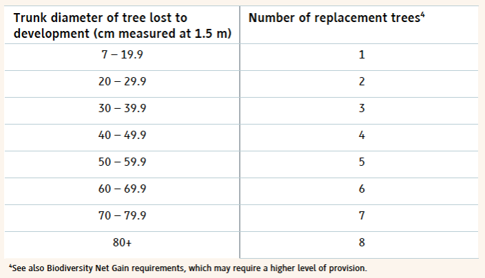
Under the new proposed policy – BG4: Trees (page 131) – trees lost to development will be replaced using this table:
Table 1 The proposed BG4 tree replacement table.
However, when the balance of EA 2021 takes effect, the current version of the BTRS will not, in most cases, be enough to achieve the 10% BNG minimum required for nearly all developments. A new Section 90A and Schedule 7A will be added to the Town and Country Planning Act 1990 and will set out the level of BNG required.
Under the statutory framework for biodiversity net gain, subject to some exceptions, every grant of planning permission is deemed to have been granted subject to the condition that the biodiversity gain objective is met (“the biodiversity gain condition”). This objective is for development to deliver at least a 10% increase in biodiversity value relative to the pre-development biodiversity value of the onsite habitat. …
Many development proposals will aim to achieve more than the minimum 10% gain voluntarily. Others may not but will still need to achieve much more in order to comply with the SM trading rules (page 140). This is based on the habitat type lost and its distinctiveness. In the case of Individual tree habitats – Urban or Rural – losses must be replaced within the same broad habitat (i.e. more Individual trees) or with a habitat of a higher distinctiveness.
However, for the sake of certainty, we propose only using the minimum 10% BNG required.
Our proposed new BG4 (BTRS) model
We propose that the table in BG4 be amended to reflect the requirements of the EA 2021 and SM and that the BG4 table (Table 1 above) be replaced with Table 2 below:
Table 2 Our proposed BG4 tree replacement requirement
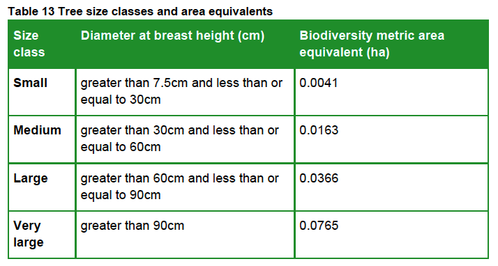
The Replacement Trees Required number is based on the habitat area of each of the four SM tree category sizes (Table 13 below), divided by the area habitat of one BNG 4.0 Small category tree (see section 3 below) plus a 10% net gain. This is rounded up to the nearest whole number (since you can’t plant a fraction of a tree).
The reasoning for our proposal is set out below:
1. Applying the Biodiversity Metric to Urban trees
Use the broad habitat type ‘Individual trees’ to record trees where:
they are found as an individual or as part of a group;
are over 7.5cm in diameter at breast height (DBH).
Individual trees should also be recorded where they meet the definition of an irreplaceable habitat but would not otherwise be recorded.
Do not otherwise record individual trees if they occur within an area habitat type characterised by the presence of trees, examples of these are:
woodlands
orchards
wood-pasture and parkland
Individual trees are classed as ‘urban’ or ‘rural’. You should consider the degree of ‘urbanisation’ of habitats around the tree and assign the best fit for the location.
2. Calculating Individual trees habitat
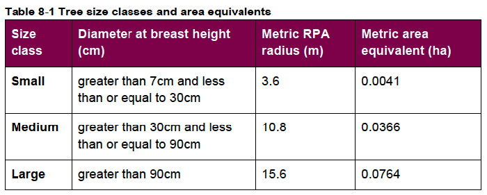
Table 13 in the SM User Guide is used to calculate the ‘area equivalent’ of individual trees:
The biodiversity metric uses set values to represent the area of trees depending on their diameter at breast height. This value is a representation of canopy biomass, and is based on the root protection area formula, derived from BS 5837:2012.
You should report the number of individual trees within your project and input tree count into the ‘tree helper’ within the biodiversity metric tool to generate area values for data input. For multi-stemmed trees, use the DBH of the largest stem. You should:
account for each individual tree within a group or block of trees.
record the habitat underneath the tree canopy separately.
not reduce any area generated by the tree helper.
not deduct the area of individual trees from other habitats.
make clear in the user comments how many trees contribute towards the total area.
Recording trees within private gardens
You should assess most individual trees that are recorded in private gardens. You should record:
any medium, large and very large trees as individual trees
any small trees that are ancient or veteran
Recording trees within hedgerows
You should assess most individual trees that are recorded within hedgerows. You should record:
any medium, large and very large trees as individual trees
any small trees unless they are ancient or veteran.
You must assess the linear value of hedgerows within the hedgerow module separately.
Individual Tree habitats have medium distinctiveness and so, under Rule 1 of SBNG, ‘Losses must be replaced by area habitat units of either medium band habitats within the same broad habitat type or, any habitat from a higher band from any broad habitat type.’
3. Forecasting the post-development area of Individual trees
The SBNG User Guide provides this guidance:
You should use the tree helper to calculate the area for created trees.
You should categorise most newly planted individual trees as ‘small’, unless the tree is medium sized or above at the time of planting.
You should not factor in the age of nursery stock when using the ‘creation in advance’ function. The ‘creation in advance’ function should only be used where trees are planted in advance of the development (for example, as screening or as structural landscaping).
Exceptions
You cannot count:
newly planted trees within private gardens
natural size increases of baseline trees
trees planted as part of hedgerow creation or enhancement as individual trees.
Our calculations are based on Small category replacement trees being planted as per the SM guidance.
4. The likely impact of this policy change
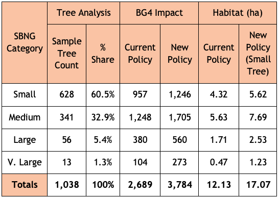
We have analysed tree data for 1,038 surveyed trees taken from a sample of BS:5837 2012 tree surveys submitted in support of previous planning applications. Most of the trees in this sample, 60.5%, fall within the SM Small tree category, 32.9% are within the Medium tree category, 5.4% are in the Large tree category with the balance, 1.3%, being categorised as Very Large.
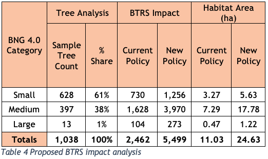
Table 4 below sets out the likely impact of the proposed changes to BG4. It assumes that all these trees were removed (though that was not the case for all the planning applications we sampled) and replaced with SM Small category trees:
When the Development Control Committee last met to discuss the Council’s application to extend the cemetery at South Bristol into the SNCI at Yew Tree Farm on 6 September 2023, we were disturbed to hear the Chief Planner’s interpretation of the meaning of ‘harmful impact’, as set out in the Local Plan policy, DM19 – ‘Development which would have a harmful impact on the nature conservation value of a Site of Nature Conservation Interest will not be permitted.’
As we received no reply at the time, we took the opportunity to ask again when the Committee reconvened to make its decision on 29 November 2023. We asked two questions – see page 9 of the Public Forum. As the responses still didn’t really satisfy, we asked two supplementary questions:
When you say, ‘the site’, what do you mean? Is it within the redline boundary or something else such as within the SNCI’s boundary?
You say ‘The crucial additional clarification to highlight, is that to be in alignment with this policy it is NOT the overall biodiversity gain that is determinative. There rather needs to be an assessment that establishes whether there is harm with reference to the specific characteristics that make the site special.’
Does this mean that the replacement of one habitat which forms part of the ‘specific characteristics that make the site special’ – such as a replacing the Grassland Habitat that forms part of the current SNCI designation with a Lake Habitat that does not form part of the current SNCI designation, or that the provision of offsite mitigation measures to compensate for onsite habitat losses (in this case -6.44%) – would not be acceptable?
These were the replies:
To question 1
By ‘the site’, it’s the site as set out in the application document, so it’s the SNCI as contained in the application document the area in the redline boundary.
To question 2 (as it is quite complex, we have reproduced it verbatim)
You need to take the application as a whole and where it is demonstrated as that with regard to the features, particularly the grassland, that there is no impact ultimately or, if anything, a slight enhanced impact.
We intervened to ask – So you are saying that the substitution of the grassland habitat for a lake habitat…?
I am not saying that at all, I am saying that the grassland, actually that there is more grassland and that’s what the ecology report also says – more grassland of the type for which the SNCI is designated will be there through this application than before… within the redline boundary.
Anyone who wants to develop land must produce a location plan of the area proposed for development, delineated by a red line – the so-called ‘redline boundary’.[1]
When planning permission is granted, only the area within the redline boundary may be developed (though ancillary works may take place elsewhere).
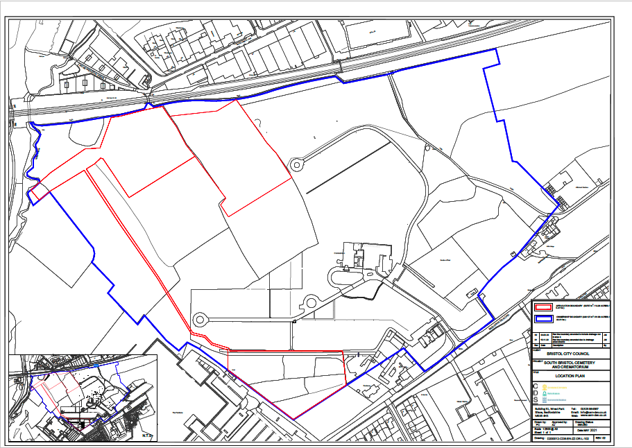
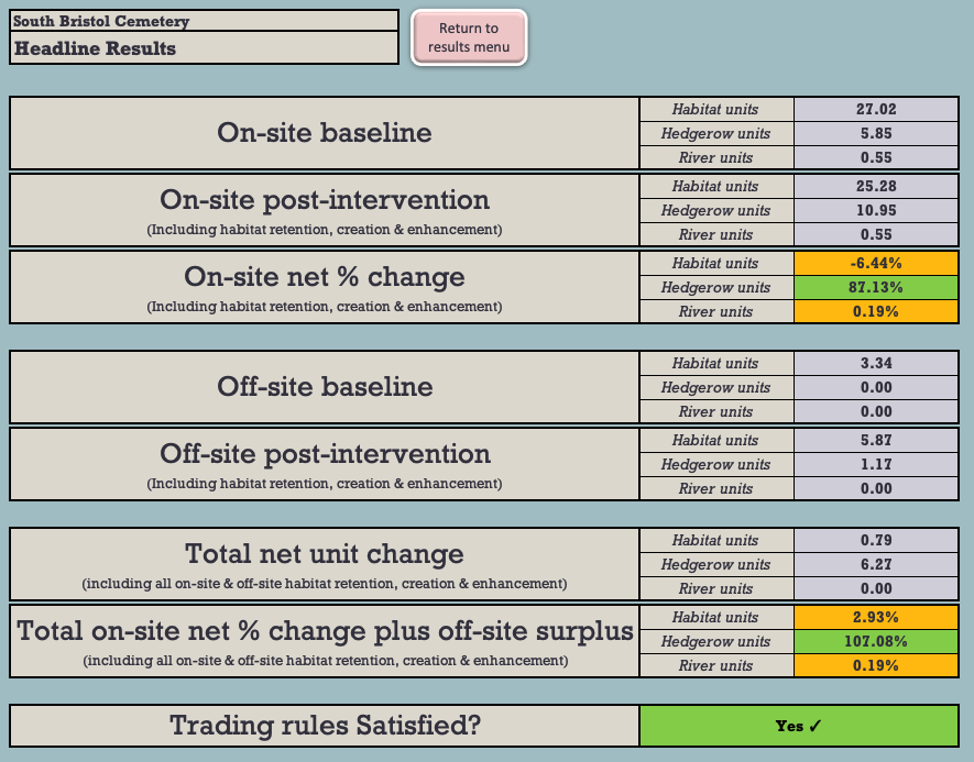
Here is the location plan for the South Bristol Cemetery Extension application:
The South Bristol Cemetery Extension location plan (North is at the top)
The redline boundary here is quite complex because it’s made up of two burial areas, in the north and south, and an attenuation pond to collect runoff from the northern burial ground through a series of drains (the southern burial ground runoff will drain straight into Colliter’s Brook to the west). The area within the blue line is also owned by the Council and so is under their control.
The redline boundary is also important when it comes to calculating the biodiversity value (BNG) of the development site. All the habitats within the redline boundary are treated as ‘onsite’, while those outside the boundary are treated as ‘offsite’.
So, when we are told that ‘… there is more grassland and that’s what the ecology report also says – more grassland of the type for which the SNCI is designated will be there through this application than before… within the redline boundary,’ it’s just the onsite area that’s being referred to. This is important, as we show below.
The headline results shown in the most recent BNG 3.1 calculation relied on by the Council[2] show that 6.44% of the baseline onsite area biodiversity will be lost as a result of the development (see Figure 1).
Figure 1: The BNG 3.1 Headline BNG results.
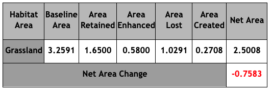
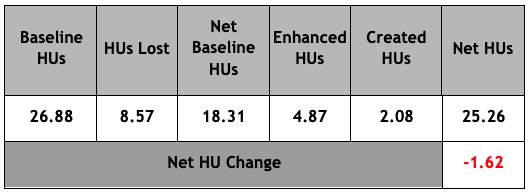
Figure 2 shows the net losses of the onsite grassland habitat:
Figure 2: Grassland Area & Habitat Unit analysis (HUs)
Under the BNG Trading Rules, Medium Distinctiveness grassland habitats may only be replaced with the other Medium Distinctiveness grassland habitats or with habitats of a Higher Distinctiveness. So, in order to achieve the net 2.93% BNG which the Council claims will result from the development, it will be necessary to compensate for these losses by crediting 3.25 Habitat Units of High Distinctiveness Lakes habitat by creating the attenuation pond.
This is not what we are told is happening and it certainly cannot be said that: ‘… there is more grassland … of the type for which the SNCI is designated … within the redline boundary,’ This is plainly untrue and, even on the Chief Planner’s definition (which we do not accept), it is clear that this application will ‘have a harmful impact on the nature conservation value of a Site of Nature Conservation Interest.’ This is contrary to DM19.
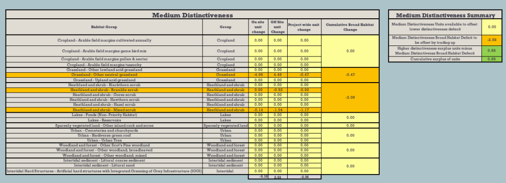
What’s more, even if the proposed offsite habitat mitigations were taken into account, there’d still be a net loss of -0.47 HU of Medium Distinctiveness grassland habitat (see Figure 4 below).
Figure 4: Net Medium Distinctiveness habitat losses
There’s one other serious flaw in the application, which was not brought to the attention of the Development Control Committee at its meeting. There’s a shortfall of -0.11 Habitat Units of the High Distinctiveness habitat, Species-rich native hedgerow with trees. Lost High Distinctiveness habitats may only be replaced like-for-like. This has not happened. As a result, the application is in breach of the BNG Trading Rules and should not have been approved.
We have brought this to the attention of the Council and the LPA.
These are just some of the important reasons why we say that the Development Control Committee was wrong to grant this flawed application.
The Mayor has now published the next iteration of the proposed new Local Plan (LP). This will be brought before you at Full Council on 31 October next. The Mayor recommends (item 8) that, under Regulation 19 of the Town and Country Planning (Local Planning) (England) Regulations 2012, the draft LP will be formally published in order for representations to be made and then submitted to the Secretary of State for examination.
The sustainability appraisal documents are published on the Local Plan Review web page.
In our opinion the proposed LP is not yet ready for further consultation, let alone independent examination, for the following reasons:
It does not contain enough detailed information about the sites in the adopted LP to allow for a proper consultation or independent examination.
Protection for green spaces has been reduced, contrary to adopted Council policy.
Despite the recent Ecological and Climate Emergency Declarations, this draft provides fewer environmental protections than the adopted LP.
Comments on earlier drafts appear largely to have been ignored, rendering the consultation process flawed.
Our response in detail
Section 20 (2) of the Planning and Compulsory Purchase Act 2004 states that the authority must not submit the proposed LP unless they think the document is ready for independent examination. In our view, the proposed LP is not yet ready for further consultation, let alone independent examination. Our reasons are set out in detail below:
A proper consultation has not been conducted. In a 2001 judgement Lord Woolf defined a proper consultation as containing four elements.[1] The final element is that ‘the product of consultation must be conscientiously taken into account when the ultimate decision is taken’. You have not responded to our carefully considered comments on both the 2019 and the 2022 consultations on earlier drafts of the LP and there is no evidence that the Local Plan Working Party even discussed them. We do not know how many other organisations who submitted comments were also ignored, because these have not been published.
When the 2019 document, New Protection for Open Space, was published for consultation, a schedule with maps was produced so that consultees could see which sites were being proposed and with what designation – Local Green Space (LGS) or Reserved Open Space (ROS). No such document has been produced in this version, which means that there is no easy way for consultees to see what has been changed, added or removed – save for slavishly working though the only document showing the new designations set out in 08.3 Appendix A3 Policies Map. Whilst this may be sufficient for those interested only in the information at ward level, it is nigh on impossible for those with a city-wide interest.
An interactive GIS map of the proposed Bristol Local Plan Policies Map should be made available to facilitate examination. The pdf version provided has 38 layers in the Key and many sites have multiple designations, which makes it very difficult to interpret. The current Local Plan Policies map does this.
Whilst the document Appendix 3 Assessing the effects of the Publication Version Policies, cross-references, to a limited extent, how some proposed new policies relate to policies in the adopted LP, there is no equivalent schedule for the adopted policies which will be removed – Core, Site Allocation and Development Management Policies (SADMP) and ancillary Supplementary Planning Documents (SPDs) etc. – nor any comprehensive cross-tabulation showing which of the adopted LP policies have been transferred to the proposed LP and which have not.
No schedule has been prepared showing those sites protected under the adopted LP and whether they will be protected under the proposed LP. For example, SADMP DM17 currently provides protection for sites designated as Important Open Spaces, Unidentified Open Spaces and Urban landscapes. It appears that DM17 will be removed but that these current protections will not be adopted in the proposed LP. We have mapped 523 Important Open Space sites covering over 2,000 hectares. As far as we can see, some 1,000 hectares of these and all Unidentified Open Spaces and Urban landscapes, will no longer have any protection. If this is the case, then the proposals should make this clear. Our recent article, Will Councillors Honour Their Promise To Protect Bristol’s Green Spaces? addresses our wider concerns.
SNCIs are currently given protection from development under SADMP DM19. This states that ‘Development which would have a harmful impact on the nature conservation value of a Site of Nature Conservation Interest will not be permitted’. It is proposed that DM19 will be removed in its entirety. Under proposed new policy BG2: Nature conservation and recovery, this protection has been changed to read: ‘Development which would have a significantly harmful impact on local wildlife and geological sites, comprising Sites of Nature Conservation Interest (SNCIs) and Regionally Important Geological Sites (RIGS) as shown on the Policies Map, will not be permitted.’ This is a dilution of the current protection enjoyed by SNCIs (and RIGS); the phrase ‘significantly harmful’ is a subjective judgement and undermines the current protection provided, especially when the Chief Planning Officer has recently advised Councillors that damage to an SNCI which is offset by onsite mitigations under the Biodiversity Metric is not harm.
Whilst we are very pleased to see that our campaign to have all those Sites of Nature Conservation Interest (SNCIs) which were allocated for development in 2014 (save for BSA1305 – why?) has succeeded and have had their Site Allocations removed, we are concerned to note that not all of the 108 sites (not 85 as is wrongly suggested) have also been designated as LGS – some are ROS and some have no designation at all. No explanation has been given for this.
No schedule of the sites identified in BG2 has been produced. As we have pointed out, there are 108 SNCIs, not the 85 stated in Appendix 1: Sustainability Appraisal Updated Scoping Report 2023 A1-4 (at page 26). A schedule of all these sites will enable consultees to identify and locate them.
In September 2021 the council unanimously resolved to protect the Green Belt and Bristol’s green spaces. Despite this, around 30 of the 96 sites proposed for residential development are green spaces (nearly 40 hectares) and three areas in our urban Green Belt are proposed to be removed from the Green Belt for development. No new green or open spaces are proposed.
Proposed policy BG4: Trees is deeply flawed. As currently drafted it will allow developers to offset tree losses by using habitats that are not allowed under BNG 4.0. If allowed this will result in the hollowing out of Bristol’s trees and frustrate the One City plan to increase tree canopy (see Annex A below).
The proposal that replacement trees ‘should be located as close as possible to the development site’ will still allow developers remove trees to build, because all they need to do is pay compensation for their replacement with no concern for where they are to be planted. This will result in trees and their biodiversity being lost from those areas under greatest development pressure, with any offsite compensation being exported to already green suburbs and creating even greater tree inequalities.
It is proposed that development which would result in the loss of ancient woodland, or ancient or veteran trees, will not be permitted, but neither Bristol’s known veteran trees nor its 11 ancient woodlands are mapped or expressly protected on the Bristol Local Plan Policies Map.
No express protection is given for other urban woodlands that are not ancient (woods that have not existed continuously since 1600), are not in a conservation area or are not protected with a TPO.
Our request
Bristol City Council has recently declared both Climate and Ecological Emergencies and resolved to protect our green spaces. The Environment Act 2021 with its still-to-be-published regulations (which will be fully implemented in 2024 together with a proposed new version of the National Planning Policy Framework) will provide even greater environmental protections and the next iteration of the One City Plan aspires to achieve a significant increase of tree canopy. Yet, against all this, the proposed new Local Plan will result in reduced protection for the environment when compared with the current, adopted Local Plan.
In light of this, we ask you to reject the Mayor’s recommendation until the above crucial issues have been addressed and insist that Bristol’s nature does not continue to suffer yet more decades of decline but is properly protected.
The Bristol Tree Forum
24 October 2023
Annex A – Email to BCC Specialist Planning Policy Officer 21 October 2023
Dear Michael,
I see that the latest iteration of the proposed Local Plan has been published. We are examining it and will comment in due course, but we have to express serious concerns about the proposed new wording of Policy BG4: Trees.
We are disappointed that our proposal for BTRS has not been adopted, but we are also very concerned that this paragraph in particular, will provide developers with an opportunity to avoid replacing lost trees at all: ‘Where the tree compensation standard is not already met in full by biodiversity net gain requirements (policy BG3 ‘Achieving biodiversity gains’), for instance because biodiversity net gain requirements do not apply to the development or because biodiversity gains are provided through a different habitat type, development will still be expected to meet the tree compensation standard on-site or off-site through an appropriate legal agreement.‘
As you know, most trees in an urban environment will be classified as broad Individual tree habitat under BNG 4.0. This broad habitat has only two sub-types – rural and urban – and can only be replaced with the same broad habitat type (Individual tree) or by a more distinctive, High or Very High habitat. This means that other Medium (e.g. most woodland habitats) or Low distinctiveness habitats cannot be used without breaking the BNG 4.0 trading rules – as BG4 currently suggests it can. These High or Very High distinctiveness habitat types are rare, especially in the urban space.
In this case, developers (who will not have the space to create all the Individual tree habitat that BNG 4.0 will demand**) will offer these or Individual tree habitats elsewhere and, because there are no such sites in Bristol, will offset the BNG losses out of the city, resulting in the hollowing out of Bristol’s trees and frustrating the One City plan to increase tree canopy.
We suggest that the proposed wording could also make BG4 unworkable because it is contrary to the BNG 4.0 rules and guidance. We suggest that you delete the words ‘or because biodiversity gains are provided through a different habitat type.’
Can you clarify whether the current Bristol Tree Replacement Standard SPD will remain, please. Is there a list of proposed deprecated policies and SPDs etc. available?
** For example, one small single dwelling development we are looking at which would require five BTRS trees to be planted to replace the three lost, will require 148 BNG 4.0 Small category trees to be planted to achieve a net gain of just 10%. There is not enough room on the site to plant the five BTRS trees, let alone 148.
Subsequent email to BCC Local Plan Team Manager 26 October 2023
Dear Colin,
I am sure you have seen our request to councillors in advance of next week’s Extraordinary Full Council meeting to adopt the Mayor’s recommendation to allow the draft Local Plan to progress to Regulation 19/20 consultation and then to independent examination. If not, I attach a copy.
We Bristolians are as much entitled to know which of their places (and a Local Plan is surely all about place) will not be protected under a new Local Plan as they are to know which will be. Yet, as far as we can see, this information has not been published with the papers laid before Councillors. Please correct me if I am wrong.
For example, we are aware that, under the 2019 document, New Protection for Open Space, it was proposed that Important Open Spaces, currently protected under SADMP DM17, would be replaced with new policies for Local Green Space (LGS) and Reserved Open Space (ROS) (para 2.13). It was obvious then that this would result in a large number of sites, currently protected under this part of DM17, losing this protection because they were not going to be designated as either LGS or ROS nor given any other protections. You will recall that it took us quite some time to get a list of these deprecated sites which we then listed in Appendix A of our response to that consultation. We have no idea whether our representations were considered. From what we have seen, it appears that, if they were, then they were ignored.
It also appears that those other places also given protection under DM17 – Unidentified Open Spacesand Urban landscapes – will also no longer be protected under the new plan, though this has not been expressly stated as far as we can see. It may well be that other place protections have also been quietly dropped and not replaced, but we cannot tell. This is why we are calling for the following schedules (preferably geolocated) to be published before the next stage of the consultation begins:
All proposed LGS/ROS designations.
All sites (places) currently protected under the adopted Local Plan and how they will be protected (or not) under the new LP.
Currently adopted policies which will be removed – Core, Site Allocation and Development Management Policies (SADMP) and ancillarySupplementary Planning Documents (SPDs) etc. – cross-tabulated to show which of these policies have been transferred to the proposed LP and which have not.
All sites proposed to be protected under BG2.
All known veteran and ancient trees and woodland within the city boundaries.
If this information is not provided then it will be impossible for those who wish to respond to the consultation to make an informed decision whether or not to accept what is being proposed and the whole consultation process will, we suggest, be fatally flawed.
I have also heard it suggested that, should Councillors not approve the Mayor’s recommendation then the current adopted Local Plan will lapse and allow developers to proceed as they wish. You know as well as I do that this is not correct. It may well be that, on appeal, developers may argue that Paragraph 11d of the NPPF applies because the Local Plan is out-of-date (Homes England argued this in the recent Brislington Meadows appeal), but this is a very different matter from what I understand has been suggested. Hopefully you will ensure that Councillors are not misled if this is repeated.
I look forward to hearing from you.
[1] R v North & East Devon Health Authority, ex parte Coughlan [2001] QB 213, [2000] 3 All ER 850, 97 LGR 703
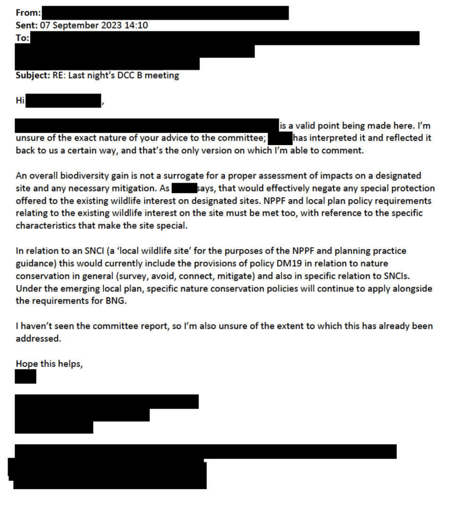
We were very disturbed to hear your advice to Councillor Pearce at last night’s Development Control Committee B meeting to consider the expansion of South Bristol Cemetery on to land used by Yew Tree Farm, a Site of Nature Conservation Interest (SNCI). You advised Councillor Pearce that the definition of ‘harm’ under SADMP DM19 was based on the net (not gross) harm caused after mitigation had been considered.
You seemed to be using Biodiversity Net Gain (BNG) as the proxy for harm, so that the reported net gain of nearly 3% was sufficient to conclude that there was no ‘harmful impact’ as defined by DM19.
Bristol Local Planning Policy DM19 plainly states that ‘Development which would have a harmful impact on the nature conservation value of a Site of Nature Conservation Interest will not be permitted.’ It could not be clearer.
If your interpretation of this is correct (and we say it cannot be), it will effectively nullify any policy protection for SNCIs or indeed, any other existing green infrastructure and all SNCIs could be developed in a free-for-all. We set out our reasoning below.
The Mitigation Hierarchy
The Mitigation Hierarchy, as enshrined at paragraph 180 a) of the NPPF, states:
When determining planning applications, local planning authorities should apply the following principles:
a) if significant harm to biodiversity resulting from a development cannot be avoided (through locating on an alternative site with less harmful impacts), adequately mitigated, or, as a last resort, compensated for, then planning permission should be refused;
On your interpretation, the first element of this cascading test, avoidance, will never have to be applied. Instead, you need only consider the second element, mitigation, for it is only then that ‘harm’ can be assessed. This cannot be the intention of this provision.
Green spaces protection
The effect of your approach is to make a nonsense of the prohibition against causing any ‘harmful impact’ to an SNCI as conferred by DM19. It effectively nullifies the special protection given to these sites. Here is the full DM19 policy wording:
On your interpretation, the whole section relating to Sites of Nature Conservation Interest may as well be deleted, as it adds nothing to the more general policy set out above.
The section relating to wildlife corridors is also rendered meaningless if there can now be no net ‘harmful impact’.
The same conclusion must also apply to the protection of Urban Landscapes under SADMP DM17, another feature which ‘contributes to nature conservation in Bristol’, on your interpretation. Your interpretation might also be extended to the other Existing Green Infrastructure identified in DM17.
Achieving BNG means there is no ‘harm’
When the Environment Act 2021’s requirement for all developments to achieve at least 10% biodiversity net gain takes effect later this year, it must follow that schemes which achieve this will have caused no ‘harm’ under your definition.
How then should this be interpreted if the net gain can only be achieved through offsite mitigation (as will often be the case)? Even in this scenario, it seems that there can never be any circumstance where an SNCI can suffer a harmful impact because it must always be mitigated by the requirement to achieve at least 10% BNG. It is even possible to imagine that the SNCI status of the target site will be lost as a result of the development, yet, as you see it, this will not be ‘harm’.
You are in effect stating that no SNCI in Bristol now has any greater protection than any ‘other habitat, species or features, which contribute to nature conservation in Bristol’ and the whole special status of SNCIs has become meaningless.
This cannot be what was intended when SNCIs were created and given special protection under the Local Plan.
We urge you to reconsider your advice.
Our statement to the Planning Committee can be read here.
Following discussions with the Council about our recent proposal to revise BTRS, we have drafted a new version which we believe will strengthen tree protection across the city even further if it is adopted into the proposed new Local Plan.
Revisions are shown in red.
The latest version of the Biodiversity Metric (BNG 4.0), just published by Natural England,[1] is likely to become mandatory when the balance of the Environment Act 2021 comes into force later this year. We have revisited our June 2022 proposals and reviewed our calculations. We have met with Bristol City Council Officers and discussed possible alternatives with them. Here is the revised version.
The Bristol Tree Replacement Standard[2] (BTRS), adopted a decade ago, provides a mechanism for calculating the number of replacements for any trees that are removed for developments. It was ground-breaking in its time as it, typically, required more than 1:1 replacement of trees lost to development and within one mile of the development.
The presumption when considering any development involving established trees should always be that trees will be retained. The application of BTRS should only ever be a last resort. Providing funds in exchange for trees that are removed on development sites should not be the default choice which it seems to have become. In addition, in many instances, the locations of the promised replacement trees are not specified and the trees are never planted. As a result, section 106 tree replacement funds continue to accumulate to the 2023 figure of approximately £800K. This figure as barely changed over the years we have been monitoring it.
The starting point for any decision on whether to remove trees (or any other green asset for that matter) is the Mitigation Hierarchy. Paragraph 180 a) of the National Planning Policy Framework sets it out as follows:
If significant harm to biodiversity resulting from a development cannot be avoided (through locating on an alternative site with less harmful impacts), adequately mitigated, or, as a last resort, compensated for, then planning permission should be refused.[3]
BTRS is and should always be ‘a last resort’. This is reflected in the Bristol Core Strategy, policy BCS9 adopts this approach and states that:
Individual green assets should be retained wherever possible and integrated into new developments.[4]
However, with the development of a new Local Plan for Bristol, we believe that the time has come for BTRS to be revised to reflect our changing understanding of the vital importance of urban trees to Bristol in the years since the final part (SADMP[5]) of the Local Plan was adopted in 2014.
In addition, Bristol has adopted Climate and Ecological Emergency Declarations so a new BTRS will be an important part of implementing these declarations. Nationally, the Environment Act 2021[6] (EA 2021) will come force later this year. This will require nearly all developments to achieve a Biodiversity Net Gain (BNG) of at least 10%. Our proposal provides a mechanism for complying with this new requirement and so aligns BTRS with the BNG provisions of the EA 2021.
Background
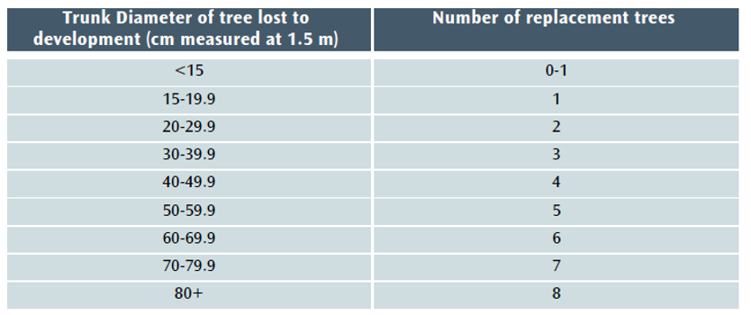
Under current policy – BCS9 and DM17[7] – trees lost to development must be replaced using this table:
Table 1 The Current DM17/BTRS replacement tree table.
However, when the balance of EA 2021 takes effect, the current version of BTRS will not, in most cases, be sufficient to achieve the 10% BNG minimum that will be required for nearly all developments. A new section 90A will be added to the Town and Country Planning Act 1990 and set out the level of BNG required (see Schedule 14 of EA 2021[8]).
The Local Government Association says of BNG that it:
…delivers measurable improvements for biodiversity by creating or enhancing habitats in association with development. Biodiversity net gain can be achieved on-site, off-site or through a combination of on-site and off-site measures.[9] GOV.UK says of the Biodiversity Metric that: where a development has an impact on biodiversity, it will ensure that the development is delivered in a way which helps to restore any biodiversity loss and seeks to deliver thriving natural spaces for local communities.[10]
This aligns perfectly with Bristol’s recent declarations of climate and ecological emergencies and with the aspirations of the Ecological Emergency Action Plan,[11] which recognises that a BNG of at least 10% net gain will become mandatory for housing and development and acknowledges that:
These strategies [the Local Nature Recovery Strategies] will guide smooth and effective delivery of Biodiversity Net…
Our proposed new BTRS model
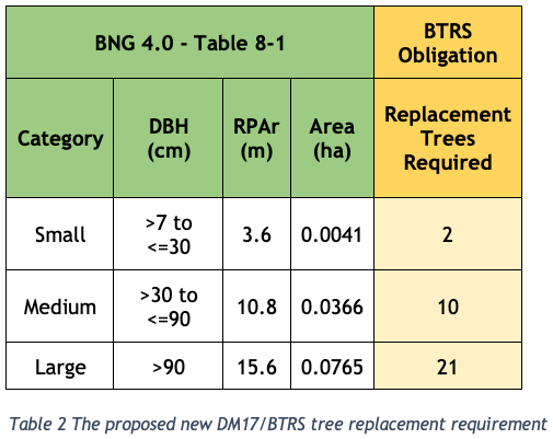
We propose that the Bristol Tree Replacement Standard be amended to reflect the requirements of the EA 2021 and BNG 4.0 and that the BTRS table (Table 1 above) be replaced with Table 2 below:
The Replacement Trees Required number is based on the habitat area of each of the three BNG 4.0 tree category sizes (Table 8-1 below) divided by the area habitat of one BNG 4.0 Small category tree (see section 3 below) plus a 10% net gain. This is rounded up to the nearest whole number – you can’t plant a fraction of a tree.
Replacing lost woodland
The current BTRS model does not deal effectively with the loss of woodland where it is impractical to measure individual tree sizes. Under BNG 4.0 these habitats are treated as Woodland and forest habitat and their habitat area is measured by the area they cover. We propose using the same method and adding 10% to allow for biodiversity net gain. The ratio will be 1 to 1.1 so that a woodland of, say, one hectare must be replaced with one which is 1.1 hectares.
The definition of a woodland is as set out in the UK Habitat Classification[12], w Woodland and forest: ‘Land with more than 25% cover of trees more than 5m in height.’
Replacing lost trees with hedgerows
The aim of BTRS is to replace lost tree habitat and canopy. Planting hedgerows cannot do this.
Whilst the planting of hedgerows is always to be encouraged, especially native species hedgerows, proposals to replace trees lost to development with hedging is very rarely a suitable solution and will not be permitted unless the developer is able to show that there are exceptional reasons for doing so. The planning arboricultural officer will need to agree the exceptional circumstances.
If a replacement hedgerow is permitted, this cannot be credited towards any BNG 4.0 calculation relating to trees. Hedgerows are a different habitat type, being linear as opposed to area based as trees are.
Making the BTRS calculation transparent
Often, years pass before trees lost to development are replaced and often the lost trees are only shown in the subsequent s106 agreement[13] as a single sum which was calculated years before and indexed to allow passage of time since the adoption of the Supplementary Planning Document (SPD) in January 2013.[14]
We would like to see a schedule set out in the S106 agreement and/or as a planning condition which itemises:
The number and identity (using Id used in the BS5837:2012 survey) of each tree to be removed.
The number and species of the trees to be planted on the development site.
The number and species of the trees to be planted on public land.
Which offsite trees are in to be planted open ground and which in hard standing.
The agreed location and species of each offsite replacement tree which and should be within one mile radius of the lost tree.
Trees planted under BTRS should not replace lost public trees, such as street trees removed in the normal course of tree management.
Like for like replacement. Compensation for the loss of large-form trees should result in large-form trees being planted.
Require that replacement trees or trees damaged as a result of the development that die within five years of planting will be replaced at the developer’s expense – This is the standard condition for trees planted on a development site.
The reasoning for our proposals is set out below:
Applying the Biodiversity Metric to Urban trees
The most recent Biodiversity Metric[15] (BNG 4.0) published by Natural England this April, defines trees in urban spaces as Individual trees called Urban tree habitats. The User Guide states that:
Individual trees may be classed as ‘urban’ or ‘rural’. Typically, urban trees will be bound by (or near) hardstanding and rural trees are likely to be found in open countryside. The assessor should consider the degree of ‘urbanisation’ of habitats around the tree and assign the best fit for the location.
Individual trees may also be found in groups or stands (with overlapping canopies) within and around the perimeter of urban land. This includes those along urban streets, highways, railways and canals, and also former field boundary trees incorporated into developments. For example, if groups of trees within the urban environment do not match the descriptions for woodland, they may be assessed as a block of individual urban trees.
Calculating Individual trees habitat
Table 8-1 in the BNG 4.0 user guide is used to calculate the ‘area equivalent’ of individual trees:
Note that the tree’s stem diameter will still need to be ascertained using BS:5837 2012,[16] and that any tree with a stem diameter (DBH) 7 mm or more and of whatever quality (even a dead tree, which offers its own habitat benefits) is included. Under the current DM17/BTRS requirement, trees with a DBH smaller than 150 mm are excluded, as are BS:5837 2012 category “U” trees. This will no longer be the case.
The Rule 3 of the BNG User guide makes it clear that like-for-like replacement is most often required, so that lost Individual trees (which have Medium distinctiveness) are to be replaced by Individual trees rather than by other habitat types of the same distinctiveness.[17]
Forecasting the post-development habitat area of new Individual trees
The BNG 4.0 User Guide provides this guidance:
8.3.13. Size classes for newly planted trees should be classified by a projected size relevant to the project timeframe.
most newly planted street trees should be categorised as ‘small’
evidence is required to justify the input of larger size classes
8.3.14. When estimating the size of planted trees consideration should be given to growth rate, which is determined by a wide range of factors, including tree vigour, geography, soil conditions, sunlight, precipitation levels and temperature.
8.3.15. Do not record natural size increases of pre-existing baseline trees within post-development calculations.
Our calculations are based on ‘small’ category replacement trees being planted.
Retain the community benefits of green assets
The current requirement that any off-site tree replacements are within a one-mile radius of the site should be retained. Were tree replacements to be allowed at any distance from the site, the local community that has lost trees due to a development would likely not benefit from their replacements. If trees lost in tree-deprived areas were to be replaced in areas with more available space and often more trees, the result would be greater inequality in tree cover. Currently, the most socially and economically deprived areas in the city centre have the lowest tree cover, and as these areas are also under the most pressure from developments, to lose this localism in tree replacement would lead to a further deprivation in tree cover for these communities.
The likely impact of this policy change
We have analysed tree data for 1,038 surveyed trees taken from a sample of BS:5837 2012 tree surveys submitted in support of previous planning applications. Most of the trees in this sample, 61%, fall within the BNG 4.0 Small range, 38% are within the Medium range, with the balance, 1%, being categorised as Large.
Table 4 below sets out the likely impact of the proposed changes to BTRS. It assumes that all these trees were removed (though that was not the case for all the planning applications we sampled):
Our proposed changes to DM17 and BTRS are set out in Appendices 1 and 2.
Appendix 1 – Our proposed changes to DM17: Development Involving Existing Green Infrastructure…
Trees
All new development will integrate important existing trees[18].
Development resulting in the loss or deterioration of irreplaceable habitats (such as ancient woodland and ancient or veteran trees) will be refused, unless there are wholly exceptional reasons and a suitable compensation strategy exists.[19]
Where tree loss or damage is unavoidable to allow for sustainable development, replacement trees of an appropriate species will be provided in accordance with the tree replacement requirements set out in the Council’s Planning Obligations – Supplementary Planning Document. …
Trees
2.17.6 Due to their characteristics and value, Aged and Veteran trees are considered to be of relatively greater importance than other trees and even trees of a similar species. Aged trees, by definition, have developed characteristics associated with great age and often have particular landscape and townscape value. Veteran trees are considered to have particularly important nature conservation value. Both will often have significant visual amenity, and potentially historic and cultural importance. As such, their loss or harm will not be permitted, and the design and layout of development will be expected to integrate them into development.
2.17.7 Trees are considered valuable multifunctional green infrastructure assets. This policy seeks to protect the most valuable trees and in line with the Core Strategy approach to green infrastructure assets, mitigate for the loss of other important trees by securing replacement trees on-site or in the public realm. The tree compensation standard set out in this policy provides a suitable mechanism to determine the appropriate level of mitigation where loss of trees is proposed as part of development.
2.17.8 The council’s Planning Obligations Supplementary Planning Document sets out the circumstances when off-site tree provision will be necessary. Where trees are to be provided off-site, planning obligations will be sought to provide the appropriate number of replacement trees, utilising the approach set out in the Supplementary Planning Document.
Appendix 2 – Our proposed changes to BTRS
Trees – Policy Background
The justification for requiring obligations in respect of new or compensatory tree planting is set out in the Environment Act 2021, Policies BCS9 and BCS11 of the Council’s Core Strategy and in DM 17 of the Council’s Site Allocations and Development Management Policies.[20]
Trigger for Obligation
Obligations in respect of trees will be required where there is an obligation under the Environment Act 2021 to compensate for the loss of biodiversity when Urban tree habitat is lost as a result of development.
Any offsite Urban tree habitat creation will take place in sites which are either on open ground or in areas of hard standing such as pavements and are located as close as possible to the site of the lost tree.
Where planting will take place directly into open ground, the contribution will be lower than where the planting is in an area of hard standing. This is because of the need to plant trees located in areas of hard standing in an engineered tree pit.
All tree planting on public land will be undertaken by the council to ensure a consistent approach and level of quality, and to reduce the likelihood of new tree stock failing to survive.
The trees planted will not replace lost public trees, such as street trees or trees in parks, removed in the normal course of tree management.
Level of Contribution
The contribution covers the cost of providing the tree pit (where appropriate), purchasing, planting, protecting, establishing and initially maintaining the new tree. The level of contribution per tree is as follows:
Tree in open ground (no tree pit required) £765.21
Tree in hard standing (tree pit required) £3,318.88[21]
The ‘open ground’ figure will apply where a development results in the loss of Council-owned trees planted in open ground. In these cases, the Council will undertake replacement tree planting in the nearest appropriate area of public open space.
In all other cases, the level of offsite compensation required will be based on the nature (in open ground or in hard standing) of the specific site which must be identified by the developer and is approved by the Council during the planning approval process. In the absence of any such agreement, the level of contribution will be for a tree in hard standing.
The calculation of the habitat required to compensate for loss of Urban trees is set out in Table 8-1 of the Biodiversity Metric (BNG), published by Natural England. This may be updated as newer versions of BNG become mandatory under the Environment Act 2021.
The following table will be used when calculating the level of contribution required by this obligation:
Were it is not reasonably practicable to ascertain the number or size of trees growing in a woodland, the level of compensation required will be 110% of the area covered by the trees, so that, for example, a woodland of one hectare will be replaced with one which is 1.1 hectares. The definition of a woodland is as set out in the UK Habitat Classification, w Woodland and forest: ‘Land with more than 25% cover of trees more than 5m in height.’[22]
The level of contribution required for planting trees in a woodland setting will be £[TBD] per 100 square metres.
Proposals to replace trees lost to development with hedging is very rarely a suitable solution and will not be permitted unless the developer is able to show that there are exceptional reasons for doing so and the planning arboricultural officer has agreed.
Planning obligations will contain the following:
The number and identity (using Id used in the BS5837:2012 survey) of each tree to be removed.
The number and species of the trees to be planted on the development site.
The number and species of the trees to be planted on public land.
Which offsite trees are in to be planted open ground and which in hard standing.
The agreed location and species of each offsite replacement tree which and should be within one mile radius of the lost tree.
Trees planted under BTRS should not replace lost public trees, such as street trees removed in the normal course of tree management.
Like for like replacement. Compensation for the loss of large-form trees should result in large-form trees being planted.
Require that replacement trees or trees damaged as a result of the development that die within five years of planting will be replaced at the developer’s expense.
[17] Table 3-2 Trading rules (Rule 3) to compensate for losses. Any habitat from a higher distinctiveness band (from any broad habitat type) may also be used. [18] Need to define what ‘important means.
[19] This is based on NPPF para. 180 c). We have inserted ‘will’ instead of ‘should’.
[20] These references may need to be changed to reflect any replacement policies adopted with the new Local Plan.
[21] These values should be updated to the current rates applicable at the time of adoption. The current indexed rates as of June 2023 are £1,171.79 & £5,082.29 respectively.
There’s a climate emergency and we need to act. With higher temperatures and more severe weather events than just a decade ago, we must take action at the local as well as the global level.
Bristol City Council declared a Climate Emergency in 2018, reflecting the need to reduce the city’s contribution to the causes of climate change, and to adapt and be resilient to further expected climate impacts. For the declaration to be meaningful, it has to result in practical changes, for example the protection of existing trees on development sites. With important urban trees being routinely felled, there is no evidence that this is the case. If Bristol continues in this way, the city will become unliveable in the climate crisis.
The Council is now drafting a tree strategy for the city, which we hope will become a key element of the forthcoming revised Local Plan. We hope that the strategy will protect existing trees and prioritise the planting of replacement and new trees across the city. We have asked for 18 principles to be included in the strategy.
If our urban environment is going to be liveable in the long term, we need to create new developments that can cope with the changes in the local climate expected in the future. The benefits of trees in the fight against climate change are now well understood: trees lock up carbon, reducing pollution and flooding. They are also the best way of reducing the urban heat island effect, decreasing the temperatures of heatwaves by up to 10°C . It’s therefore vital that green infrastructure forms part of any proposed development. This is particularly crucial in the city centre.
On every occasion that trees are felled, we’re told it will be all right, as they will be replaced. Often these replacement trees are never planted because there is nowhere to plant them, or if planted, they die and are not replaced. At any rate, we need tree canopy and shade now, not in 50 years’ time when any new trees that might survive will replace the canopy lost. This is why we must protect existing trees, and if trees must be lost, local tree replacements must be planted and not just promised.
A warmer climate increases the risk of overheating and heat-related illness, even death. In the heat wave of 2003, around 70,000 people died across Europe due to the extreme heat, with older people and children particularly vulnerable. However, we can reduce much of the risk without the need for active cooling, by incorporating effective measures into development proposals from the earliest design stage. New buildings and external spaces must be designed to provide year-round comfort and support well-being. On-site tree planting for shade will contribute to this by minimising the amount of heat entering buildings. All new developments will be expected to demonstrate through ‘sustainability statements’ how they would incorporate such measures into their design from the outset.
How green (and blue) infrastructure reduces climate impacts
Developers must take into account that changes in the local climate are likely to: increase flood risk and water stress; change the shrink-swell characteristics of clay soils affecting foundations and pipework; affect slope stability; and affect the durability of building materials. Incorporating green and blue infrastructure, such as trees and water features, in developments will help to reduce all these effects. Green and blue infrastructure should be multifunctional, that is, provide ecology and biodiversity benefits as well as climate adaptation in developments. Where appropriate, this should include the use of living roofs with a sufficient substrate depth to maximise cooling benefits. However, the cooling effect of green roofs is a fraction of that afforded by trees.
Long-term thinking
As we build more homes, businesses and communities, it’s essential that we retain and integrate important existing trees within any new development. We must also consider carefully the size, species and placement of new trees provided as part of any planned landscape treatment, for example in terms of:
ensuring that any new streets are tree-lined
focusing once again on large-form trees that will be long-lived and provide substantial shade, rather than small, short-lived trees such as Rowan or Amelanchier
reducing or mitigating run-off and flood risk on the site
increasing on-site canopy cover and providing shade and shelter
ensuring that newly planted trees will be maintained in the long term and replaced if necessary.
Where tree loss or damage is unavoidable, and not merely expedient, within a development site, new replacement trees of an appropriate species must be provided either on or off site and their long-term management and maintenance secured.