To calculate the biodiversity value of a habitat, it’s important to assess its strategic significance. A habitat’s strategic significance takes into account both its type and its location. If strategic significance is high, then the habitat’s value will be uplifted by 15%. However, as this article explains, the opportunities for doing this are limited.
A habitat parcel is an area of habitat which is all of the same distinctiveness, condition and strategic significance. Strategic significance refers to the importance of a habitat parcel based on its location and type.
Each habitat parcel needs to be assessed both before, when the baseline habitat is surveyed, and after development, on or off site.
This flowchart sets out how to assess the strategic significance of a habitat parcel. It uses the tables, shown below, from the Statutory Biodiversity Metric User Guide.
When developers cannot meet their obligation to replace habitat lost within their development site, plus at least 10%, they may buy habitat units to offset this lost habitat. These habitat units are available in ‘biodiversity gain sites’.
This article was updated on 23 February 2025 to take account of the development of our new site which dynamically analyses the Biodiversity Gain Register and collates and summarises the published data:
To date, 46 of these biodiversity gain sites (BGS) have been registered in England. They provide:
1,376.7 hectares (ha) of baseline area habitat.
32.76 kilometres (km) of baseline hedgerow habitat.
11.37 km of baseline watercourse habitat.
The BGS sites cover 1,770.41 ha, though not all of this area is used for habitat improvement. 1,420.83 ha baseline habitats are made available for offsetting habitat loss caused by development elsewhere where this lost habitat cannot be replaced on the development site itself.
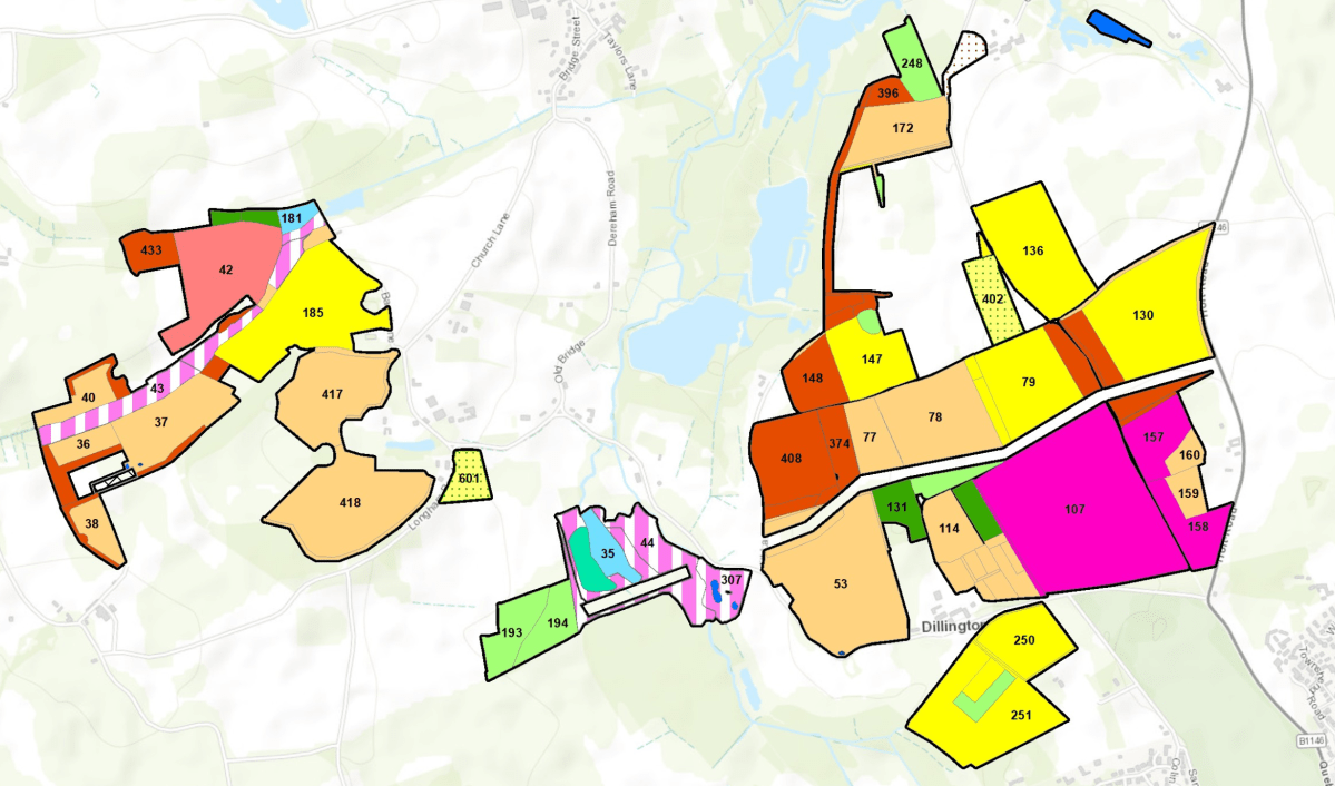
Distribution of biodiversity gain sites in England
19 of the 46 BGS sites are controlled by RSK Biocensus Limited as the Responsible Body but are mostly owned by Environment Bank. One other is controlled by Harry Ferguson Holdings (based on the Isle of Wight) as the Responsible Body, with the remaining sites under the control of various Local Planning Authorities (LPA) as the Responsible Body. We assume that the LPA sites have been created in order to deal with those local developments which require offsite mitigation. Nonetheless, these sites are also selling habitat to developers which require offsite mitigation but are outside the LPA boundary.
We also ask who is policing these sites to ensure that was has bee promised is being delivered? This must especially be the case for LPA sites given that the LPA cannot monitor itself?
In Bristol the LPA has delegated this function to neighbouring authorities using s.101 Local Government Act 1972 (the power for councils to delegate functions to other local authorities). – See 30 Sept 2024 Economy and Skills Committee notes – from paragraph 9. It will be interesting to see how this turns out. However, despite this, no BGS sites have yet been registered in the city, so it is hard to see how this initiative will be delivered where offsite mitigation is required.
The habitat improvement potential
These sites provide a total of 4,819.3 area baseline habitat units (HUs), 325.59 hedgerow baseline HUs and 105.6 watercourse HUs – we have assumed that all the sites have low strategic significance and that the watercourse habitats are free of encroachment.
We have been able to calculate the improved habitat units being created but not the improved habitat units being enhanced. This is because the parameters upon which these baseline habitats are being improved have not been identified.
The take up to date
So far, 31 of these 46 BGS sites have been used by 59 LPAs to allocate lost habitat caused by 85 developments. The majority of habitats are Other neutral grassland and the remainder are Lowland meadows, Traditional orchards, Floodplain wetland mosaic and CFGM, Mixed scrub, Woodland and forest and Hedgerow habitat.
To encourage developers to choose sites as close as possible to the habitat loss, they don’t need to pay a ‘spatial risk’ penalty if the biodiversity gain site is within the same Local Planning Authority (LPA) as the development. However, if the biodiversity gain site is outside the LPA for a particular development, the developer must pay a penalty when calculating the number of habitat units to be offset. If the site is in an adjacent LPA, the penalty is 25%. If it is farther away, the penalty is 50%.
Unfortunately, it appears that developers are not using BGS within their LPA areas (if available) for offsetting but are paying the spatial risk premium, though perhaps this is because they have no choice as there are no local BGS sites available.
Our analysis shows that, to date, the average distance between the centre of the LPA* where the habitat was lost and where its loss is offset is 80.1 km, with the greatest distance between loss and replacement being 344.8 km. Only six sites are within 10 km of the site of the habitat loss, while 23 are over 100 km away.
* It is difficult automatically to calculate the exact site of the habitat loss on the basis of the information provided. If at least Post Codes were provided, this would be possible.
What is particularly notable is that many of the development sites we have examined appear to be in locations where there should be ample opportunities for local habitat to be improved, but nothing has been done to realise this. Even the South Downs National Park LPA has allowed the replacement of habitat lost in two applications on the same site under its care near Petersfield to be exported to a site some 67 km away near Lewes, albeit that it is still in the National Park.
Furthermore, all 46 of the BGS sites are located on private land, in rural settings that are not easily accessible, whereas the lost habitats were largely located in built-up areas.
However, given the requirement that offsite mitigation only be delivered on registered sites, its hard to see what choice developers have apart from testing the BGS market and buying the cheapest habitats required, albeit that this may be miles from the site of the original loss.
This is still a small sample, which will grow over time so, perhaps this will change as more biodiversity gain sites become available and a clearer trend emerges. At the moment, however, the trend is not encouraging and looks like it will result in local nature, especially in urban settings, becoming hollowed out, as we feared it would when the biodiversity net gain requirements became obligatory nearly a year ago. See our article on this: ‘It seems inevitable Bristol will see a steady, inexorable biodiversity decline’
In a boost for the environment, new legislation now obliges most developers to set out how they will achieve at least 10% more biodiversity than already exists on their proposed development sites.
Developers must now show how they will improve the biodiversity of their development site as a result of their works. Developers must record the (baseline) on-site habitats that exist before development starts and show how they will either enhance or replace these on site. If their proposals fail to reach the 10% threshold, the developer may provide the shortfall elsewhere. This post-development mitigation should be done as closely as possible to the development site, or at least within the Local Authority. However, if this isn’t possible, they can use approved sites anywhere in England.
This approach is called the Biodiversity Gain Hierarchy (found in Schedule 7A of the Town and Country Planning Act 1990 at section 37A). The Hierarchy says it’s a priority to avoid the ‘adverse effects’ to ‘onsite habitat with a habitat distinctiveness score … equal to or higher than four.’ If this can’t be avoided, only then is mitigation permitted. In our experience, nearly all developers ignore the requirement to avoid adverse effects and move straight on to mitigation.
Since the introduction of the Bristol Tree Replacement Standard in 2013, developers (and planners) have ignored the policy requirement to avoid tree removal where at all possible. Instead, they’ve moved straight on to providing compensation for the trees lost to the development. As a result, the money set aside for replacement tree planting was not spent (on occasion reaching nearly £1 million) and many of the lost trees were never replaced.
Under the Hierarchy, habitats that score four are designated as having medium distinctiveness. While many habitats have medium distinctiveness, many don’t. For example, managed grassed areas (called ‘modified grassland’) are often found on urban sites but have a low distinctiveness score. So, too, do many other urban habitats such as allotments and gardens. Developers are not required to avoid harming these, though losses to these habitats must still be mitigated.
There’s no definition of what an ‘adverse effect’ is or any guidance on how it is assessed. However, recent advice from the Bristol’s Chief Planner about the meaning of ‘harm’ suggests that this could be interpreted very broadly or simply ignored because some sort of mitigation will always be available.
In the last extreme, developers may purchase biodiversity credits. We wait to see how this and the offsite biodiversity mitigation market evolves, but a 2012 paper published in the Harvard Environmental Law Review suggests that such environmental markets are prisoners of their own geography because the space available is always constrained:
Markets for water quality, biodiversity, endangered species, fisheries, air quality, and aquatic resources, to name a few, must recognize that the commodities they trade exist at particular geographic scales, and set appropriate spatial limits on the redistribution of environmental quality. The size of geographic trading areas has significant implications for the economic viability of markets and the ecological quality of their offsets.
This will be a particular challenge when providing biodiversity mitigation in urban areas.
The squeeze on green spaces
Land use in Bristol is subject to intense competition by many stakeholders. This is especially true for our green and open spaces, which offer many ‘services’ beyond just habitat provision. There is very little, if any, space available for new biodiversity to be created. At best, some green spaces might be enhanced, but opportunities to do this are likely to be very limited.
For example, Bristol Tree Forum’s examination of the three proposals to develop Bedminster Green shows that, if these proposals are allowed, then nearly 400 new trees will need to be planted to compensate for the lost tree habitat – a medium distinctiveness habitat. There’s no room to plant these trees on site, so offsite provision will be needed. There are very few opportunities for doing any new tree planting (as opposed to replacing lost trees) in the surrounding wards or even across Bristol, let alone, as is usually required, within a mile of a development site.
Instead, these replacement trees will have to be planted somewhere else: ‘in some foreign field that is forever Bristol’. This will inevitably lead to a net loss of biodiversity across the city as nature is ‘hollowed out’. This is unacceptable. The whole purpose of the new biodiversity gain regime is to improve overall local biodiversity, but it seems inevitable that Bristol will instead see a steady, inexorable decline.
We are disappointed that the current draft of the new Local Plan addresses none of these issues and have said so in our responses to the latest consultation:
The new Biodiversity Net Gain (BNG) obligations, which came into force last February, aim to improve our natural environment by requiring that all new developments have a positive impact (a net gain of at least 10%) on biodiversity.
For this reason, we believe that Bristol urgently needs to follow the lead of the other west of England councils, B&NES, South Gloucestershire and North Somerset, and adopt a Biodiversity Net Gain Supplementary Planning Document (SPD). A list of other local authorities that have adopted their own biodiversity SPDs can be seen here on the Local Government Association planning advisory service website – Biodiversity Net Gain in Local Plans and Strategic Planning.
Councils are encouraged to develop a locally specific SPD as part of their Local Plan. This would:
set out local priorities and strategies that require developers to deliver BNG locally
ensure that BNG contributes to wider nature recovery plans such as the newly launched Local Nature Recovery Strategy (LNRS) and other local objectives, and help ensure that the right habitats are provided in the right places
link BNG requirements to other strategic objectives and place-making policies in the Local Plan, to ensure a more holistic approach
set requirements for managing and maintaining habitats provided through development.
Having such a document would clarify exactly what developers need to do in terms of the BNG requirements. While these requirements have many gaps, they are now, as it were, the only game in town and we must try to make the best of them. We believe that developing a robust BNG SPD could help mitigate these problems by adding tougher conditions that developers must meet.
With the launch of the LNRS – a collaborative effort to help people and organisations within WECA and North Somerset take effective action for nature – it has become more important than ever for Bristol City Council to bring this strategy into action, especially where new development is planned.
Two factors causing us the most concern (there are others) are the exclusion of stakeholders from the BNG decision process and the lack of enforcement of BNG requirements.
Consulting stakeholders
We’ve long been concerned that the new BNG regime excludes stakeholder groups such as ours from engaging with and commenting on the approval process for Biodiversity Gain Plans (BGPs) because of the way the planning rules work.
The BGPs are a post-approval requirement (see Schedule 7A of the TCPA ’90, Part 2, section 13(1)), which means there’s no obligation for a developer to demonstrate how it will meet its BNG responsibilities during the application stage (although the Council could require this).
Under current rules, BGPs only need to be submitted for approval to the Planning Authority after an application has been approved. However, there’s no statutory requirement to consult any statutory bodies on BGPs or to publicise or consult on the submission of a BGP prior to its approval. It seems, therefore, that we (and other stakeholders who, like us, are fighting for everyday nature) will have no say in what is proposed, or even have any idea of what a BGP contains or how it could affect us.
Surely this goes against the principles of open governance and localism which councillors should be fighting to defend, especially where it’s likely to have a direct impact on the very places that we Bristolians love and value?
Improving enforcement
As a recent article in Local Government Lawyer magazine points out, there are serious issues around BNG enforcement that need to be resolved.
We’ve been trying to engage with council officers over this issue for some time, but so far without success. Maybe the time has come for the Council to seize the initiative? With the proposed new Local Plan moving towards its public hearings stage early next year and the likelihood that the plan will be adopted next April, maybe now is the time for the reconstituted Local Plan Working Group to take this in hand.
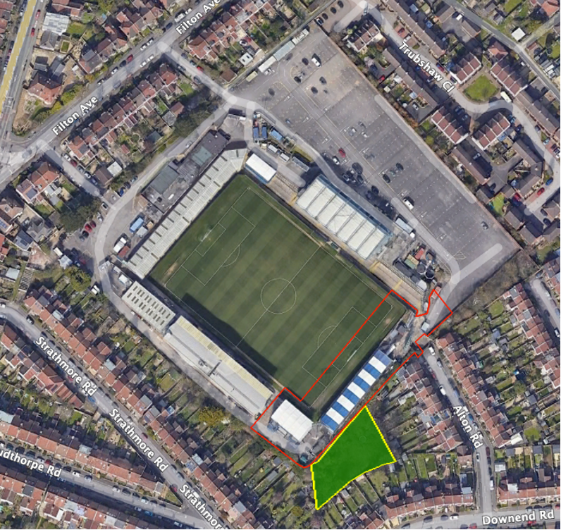
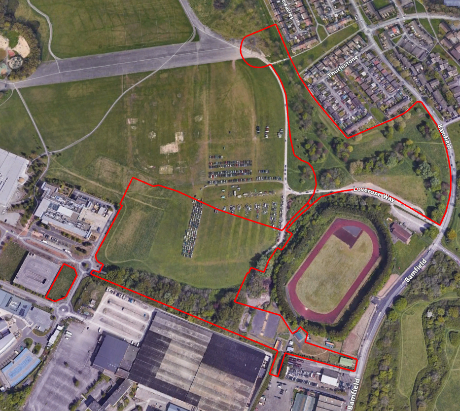
One of our fears is that some planning conditions, such as this one from the recent, pre 12 February 2024, Bristol Rovers Memorial Grounds application are unenforceable. In this case they only oblige the club to submit a proposed Landscape Ecological Management Plan (LEMP). They did this last June. However, the wording of the condition means that the club is not obliged to perfect this or even to carry it out.
Readers may recall that the development had been completed and the new stands occupied long before the main application was made, well before this and other conditions had been submitted or approved. In addition, as part of the eventual approval, the club agreed to plant a wood on a piece of unused land it owns to the south of the new stadium (the area shaded green below), but this has not yet been done.
As part of this agreement, the club is expected to enter into a LEMP to plant the wood and then maintain it in perpetuity. The LEMP Condition says:
Within 6 months of the date of consent, the applicant shall submit a 30-year Landscape and Ecological Management Plan (LEMP). This should address retained features of ecological interest, together with mitigation and enhancements to be provided. The LEMP should set out management compartments, objectives, and prescriptions for all new proposed soft landscaping/planting to demonstrate how all habitats will be managed to their target condition (as specified in the BNGA). It should also show how management of the site will be resourced and monitored.
In this example, all that can be enforced is a failure to submit the LEMP within six months, which, in this case, has been done. There is a S106 imposing LEMP obligations but this is toothless and, anyway, only the Council can enforce it – which it is not obliged to do.
There’s also the practical effect of the Biodiversity Gain Hierarchy – Biodiversity net gain Guidance Paragraph: 008 Reference ID: 74-008-20240214. This effectively means that the developer need not achieve any net gain on site, or even locally, but can instead deliver it anywhere in England or, as a last resort, simply buy BNG credits, though at a premium.
For example, the grant conditions – 11 (The BGP condition), 12 & 14 – in the recent, post-12 February Council application, The White Hall, Glencoyne Square, are unenforceable given their wording as there is only an obligation to submit; again, approval is not required. We assume that a s106 agreement and a Habitat Management and Monitoring Policy (HMMP) will need to be produced, but, at the moment, we still have no idea how the self-acknowledged 38.09% habitat loss will be mitigated, or where.
Given the intense competition for space in the city, it seems inevitable that, as a result of the application of the Biodiversity Gain Hierarchy, Bristol’s nature will, bit by bit, be exported to some far-off field that no one knows or cares about. In theory, a BNG SPD could at least try to ensure that habitats lost to development are replaced locally wherever possible.
It’s been suggested that new SPDs can’t be delivered until after the new Local Plan has been examined and formally adopted. Maybe, but we see no reason why we can’t at least start a conversation about this. As it is, the proposed Local Plan will need substantial redrafting to align with the new BNG rules, having been adopted by the Council before these had been finalised.
It’s also been suggested that there are neither the funds nor enough officer time available to develop this new SPD. However, since all the adjacent councils (members of WECA), and many farther afield, have developed, or are developing, their own SPDs, we can surely save time and expense by looking on these as templates from which to build our own. The examples above alone make it all the more urgent for issues such as this to be resolved with the early adoption of a BNG SPD. We urge the Council to commission officers to draft an SPD as a matter of urgency.
There are six criteria for assessing a tree’s condition. If a tree passes five or six of the criteria, it is in good condition. If it passes three or four of the criteria, it is in moderate condition. If it passes two or fewer of the criteria, it is in poor condition.
These are the six criteria to consider:
A – The tree is a native species (or at least 70% of the block are native species). B – The tree canopy is predominantly continuous, with gaps in canopy cover making up <10% of total area and no individual gap being >5 m wide (individual trees automatically pass this criterion). C – The tree is mature (or more than 50% of the block are mature). D – There is little or no evidence of an adverse impact on tree health by human activities (such as vandalism, herbicide or detrimental agricultural activity). And there is no current regular pruning regime, so the trees retain >75% of expected canopy for their age range and height. E – Natural ecological niches for vertebrates and invertebrates are present, such as deadwood, cavities, ivy and loose bark. F – More than 20% of the tree canopy area is oversailing vegetation beneath.
The ‘Fairly Good’ and ‘Fairly Poor’ condition categories are not available for this habitat type.
Enhancement of this habitat is only possible by improving it so that it meets the criteria B, D and F. It is not possible or appropriate to enhance individual tree/s through meeting just one or two of these criteria, nor by meeting only A or C or E.
It is important that the species of each tree on site is properly listed by the developer. Here is the list of the native species defined by the Statutory Metric:
With the introduction of the Biodiversity Metric, all existing (i.e. baseline) habitat parcels on proposed development sites are given a calculated habitat value, called Habitat Units (HUs).
Baseline habitat parcels
Baseline habitat is the habitat that exists before a site is developed. Development sites often contain a mosaic of baseline habitats each of whose condition may vary. These are called habitat parcels.
The area of a habitat parcel is measured in hectares (or square metres when using the Small Sites Metric). Linear habitats parcels are measured in kilometres (or metres when using the Small Sites Metric).
The sum of all the ground-based area habitat parcels should equal the area of the proposed development site (the redline boundary).
Calculating HUs
The HU calculation uses the following formula:
HU = Habitat area/length x Distinctiveness x Condition x Strategic Significance.
The Distinctiveness of each habitat is predefined. These are the Distinctiveness scores:
The Strategic significance of a habitat is its importance according to its location and habitat type. Each of these elements is given a score which is then used in the HU formula. These are thescores:
High
1.15
Medium
1.1
Low
1
For example, an area habitat parcel covering a hectare, which is of medium distinctiveness, in moderate condition and of medium strategic significance, is calculated as follows:
1 ha (area) x 4 (distinctiveness) x 2 (condition) x 1.1 (strategic significance) = 8.8 HUs.
Individual trees habitat
There is a special formula for individual trees habitats. This is because they oversail the habitat on the ground and so are non- ground-based habitats, which need to be treated differently from ground-based habitats.
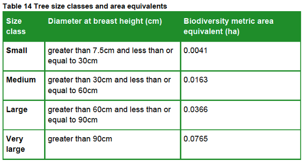
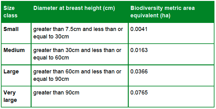
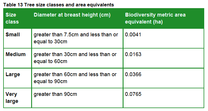
This table shows the four size classes for Individual trees habitats:
It uses the diameter at breast height (DBH measured 1.5 metres above the ground) of each tree growing on a proposed development site (if the tree is multi-stemmed, the largest DBH recorded is used) and assigns a ‘Biodiversity metric area equivalent’ to calculate its habitat area. This value represents canopy biomass, and is based on (but not the same as) the root protection area formula, derived from BS 5837:2012.
For example, a medium-size individual trees habitat covers an area of 0.0163 ha and has medium Distinctiveness. If it is in moderate Condition and of medium Strategic significance the HU value is calculated as follows:
0.0163 ha (area) x 4 (distinctiveness) x 2 (condition) x 1.1 (strategic significance) = 0.14344 HUs.
Post-development habitat creation and enhancement
The biodiversity metric also applies three additional risk factors to all post-development enhanced and created habitat parcels, across all three habitat types – Area, Hedgerow and Watercourse – using this formula:
HU = Habitat area/length x Distinctiveness x Condition x Strategic Significance x Temporal Risk x Difficulty factor x Spatial Risk
Temporal risk
This represents the average time lag between the start of habitat parcel creation or enhancement works and the target outcome date. This is known as the ‘time-to-target condition’ and is measured in years.
If there is a delay in creating or enhancing the habitat parcel, or it has already been enhanced or created, this can be factored in to adjust the time-to-target period either up or down.
The temporal risk period is automatically applied by the biodiversity metric and changes depending on target habitat condition. As a result, the temporal risk multiplier, based on the 3.5% discount table below, sets the current value of the future habitat being created.
Difficulty of creation or enhancement
The creation and enhancement categories represent the uncertainty of the effectiveness of techniques to create or enhance habitat parcels.
The biodiversity metric automatically assigns the delivery risk and score for each habitat parcel, based on its habitat intervention category.
Category
Value
Low
1
Medium
0.67
High
0.33
Very High
0.1
Spatial risk
Where a project cannot achieve a net gain in biodiversity units on site, then offsite HUs can be used to meet the BNG requirement.
The spatial risk penalty (SRM) reflects the relationship between the location of on-site biodiversity loss and the location of off-site habitat compensation. It affects the number of biodiversity units provided to a project by penalising proposals where off-site habitat is located at a distance from the development site.
If the offsite area is within Local Planning Authority (LPA) boundary or National Character Area (NCA), the penalty is x 1.0.
If it is in a neighbouring LPA or NCA, the penalty is x 0.75.
If it is elsewhere (anywhere in England), the penalty is x 0.5.
The effect of this is that it costs more HUs to achieve the BNG requirement the farther away the offsite mitigation is from the location of on-site biodiversity loss.
Post-development Individual trees habitat creation
When creating Individual trees habitat, post-development size class of a tree is determined by its size when it is planted. Newly planted trees should be recorded as small-sized, unless the tree is actually medium-sized or above at the time of planting.
In our experience, nearly all nursery-grown trees are small-sized, as this table, derived from BS 3936-1, demonstrates.
For example, a small-sized tree covers an area of 0.0041 ha and has medium Distinctiveness. The difficulty of creation factor is preset at Low.
If it is planned for it to achieve a moderate Condition, the time-to-target period will be 27 years. If it is planted within the LPA in an area of medium Strategic significance, its HU value will be calculated as follows:
0.0041 ha (area) x 4 (distinctiveness) x 2 (condition) x 1.1 (strategic significance) x 0.382 (temporal risk) x 1 (difficult factor) x 1 (spatial risk) = 0.01378 HUs.
Much has been made of the new rules that require most developments to add at least 10% more biodiversity to a site than was present before development took place. This requirement is known as biodiversity net gain (BNG).
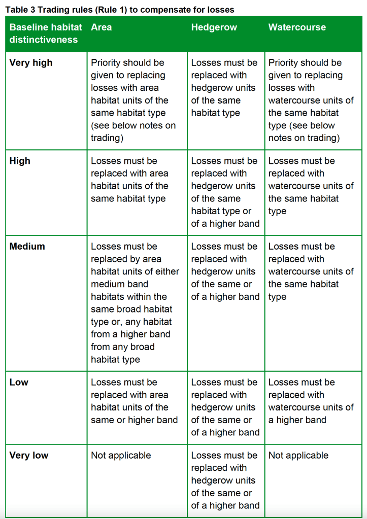
However, a much-overlooked aspect of the new rules is the requirement also to comply with so-called trading rules.
These trading rules set minimum requirements for habitat creation and enhancement to compensate for specific habitat losses resulting from a new development.
If these rules are not followed, a developer cannot claim that there is biodiversity net gain, even if the planning application has achieved the minimum 10% BNG required.
Rule 2 states that biodiversity unit outputs for each habitat type – Area, Hedgerow or Watercourse – must not be added together, traded, or converted between types. The requirement to deliver at least a 10% net gain applies to each separate habitat type.
The trading rules only apply to the point of no net loss of a specific habitat. Once the trading rules have been met for this habitat, the biodiversity net gain requirements can be met by the creation and enhancement of any other habitat, provided it is the same habitat type.
This table from the Statutory Metric sets out how they apply:
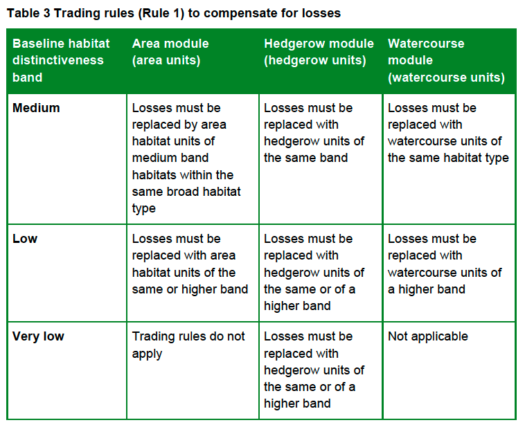
The trading rules for the SSM are slightly different. This is because the SSM does not cater for high and very high distinctiveness habitats (if these are present, the Statutory Metric must be used):
Although the calculator warns of any breaches of the trading rules, the design of the SSM does not allow users to identify where the breaches have occurred. However, the Statutory Metric does. So, if the habitats input into the SSM calculator are transposed to the Statutory Metric calculator, this will reveal where the trading rules breaches are and allow the user to consider how to mitigate the losses whilst still complying with the trading rules.
There are special rules for very high distinctiveness habitats and for compensating for loss of watercourses and high distinctiveness woodland, which are not addressed here.
How the trading rules apply to urban tree habitats
Individual trees habitat has medium distinctiveness. This means that this habitat can only be replaced like for like, although higher distinctiveness habitats can be substituted when the Statutory Metric is used.
Other broad habitats with the same distinctiveness cannot be substituted. For example, Woodland and forest habitat cannot be used to replace lost Individual trees habitat unless it has a higher distinctiveness and the SSM is not being used.
As a result, the requirement to replace lost trees can result in many more trees having to be planted (often off site) than will be lost. In one recent example we examined, 116 replacement trees were needed to comply with the trading rules, even though only 12 were being removed.
Hopefully, developers will now think twice before seeking to remove trees to make way for their plans.
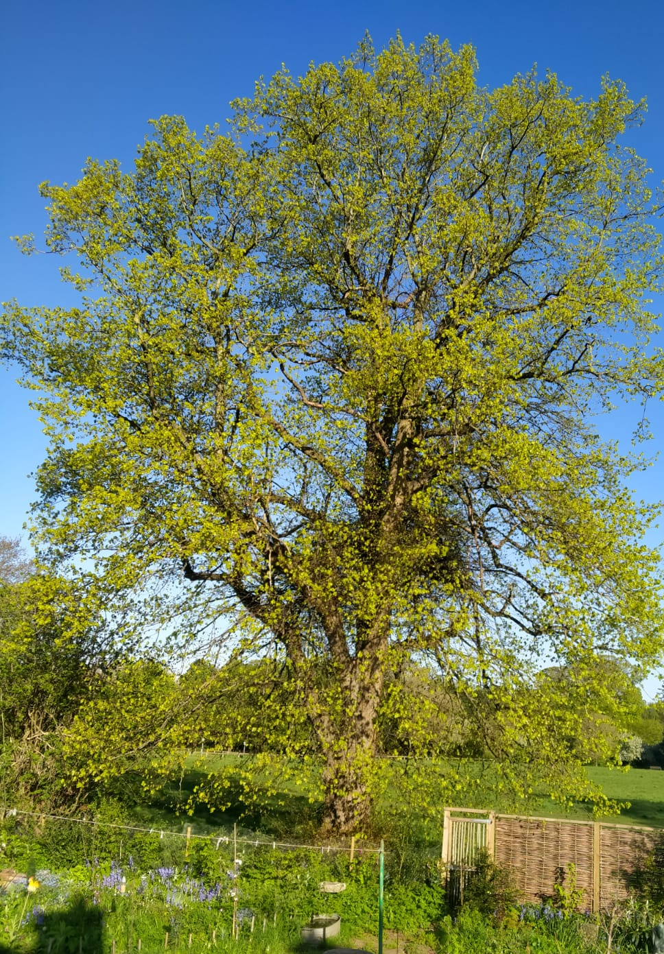
A key factor in calculating the value of a habitat under the new Statutory Biodiversity Metric is to work out its size. In the case of trees, their habitat size can be of critical importance to the calculation of their biodiversity valuation which will, in turn, help to preserve our precious tree habitats.
As a result, individual trees in an urban setting are often the most important habitat present.
Unfortunately, developers may be tempted to allocate all trees on their planned development site (especially those in groups) to Woodland and forest habitats rather than to Individual trees habitat, because this gives the trees and the site a lower biodiversity value. An example of this is the proposed development by Goram Homes of Hengrove Park in Bristol, as shown in the image above and discussed below. The whole site was granted outline planning permission in October 2019.
Unfortunately, the Statutory Biodiversity Metric User Guide (the Metric) definitions of these habitats are ambiguous and can make such allocations hard to counter, even in settings that are clearly urban.
The User Guide defines two broad tree habitats types whose areas are measured in hectares (ha):
Woodland and forest
Individual trees
Defining woodland and forest habitat
There are conflicting definitions of ‘woodland’. The Metric User Guide does not define Woodland and forest habitat.
However, the UK Habitat Classification, UKHab, upon which the Metric is based, defines it as ‘Land with 25% or more cover of trees that are five metres or more in height.’ This definition doesn’t mention the minimum land area required.
‘a minimum area of 0.5 hectares under stands of trees with, or with the potential to achieve, tree crown cover of more than 20% of the ground. Areas of young trees, which have the potential to achieve a canopy cover of more than 20%, will also be interpreted as woodland and mapped. The minimum width for woodland is 20 m, although where woodlands are connected by a narrow neck of woodland less than 20 m wide, the break may be disregarded if less than 20 m in extent.‘
Bristol City Council also uses area to define woodland in its 2008 Biodiversity Action Plan (Chapter 5, page 65), which states that ‘this action plan covers all woodlands over 0.5 hectares in extent found in Bristol.‘ As this is a local policy, and aligned with the NFI definition, we have adopted it.
The habitat area of Woodland and forest habitats is based on its total measured canopy area.
Defining individual trees habitat
The Metric User Guide (page 53) advises when to record Individual trees habitat:
Individual trees are classed as ‘urban’ or ‘rural’. You should consider the degree of ‘urbanisation’ of habitats around the tree and assign the best fit for the location.
Use the broad habitat type ‘Individual trees’ to record:
individual rural trees
individual urban trees
lines, blocks or groups of trees found within and around the perimeter of urban land.
In all circumstances ‘Individual trees’ should be used to record ancient and veteran trees, regardless of location. This could include ancient and veteran trees within hedgerows, ‘rural’ lines of trees and woodlands.
Other clarifications
Do not use the hedgerow module classifications ‘line of trees’ and ‘ecologically valuable line of trees’ to record linear formations of trees in the urban environment.
These classifications should only be used for rural lines of trees. Trees within overgrown non-native and ornamental hedges (for example, leylandii) should not be classified as individual trees, or as lines of trees. Record these as nonnative ornamental hedges within the hedgerow module.
Trees recorded as individual trees that will be removed for any purpose, including development, disease, or safety must be recorded in your baseline and recorded as lost.
Do not otherwise record individual trees if they occur within a habitat type characterised by the presence of trees, unless specified within the section on ‘recording individual trees at baseline’, which covers:
trees within private gardens
removal of trees within hedgerows
removal of trees within rural lines of trees
removal of trees within orchards and wood-pasture and parkland
Recording individual trees at baseline
The biodiversity metric uses set values to represent the area of individual trees depending on their diameter at breast height.
This value is a representation of canopy biomass, and is based on the root protection area formula, derived from BS 5837:2012.
Table 14 sets out class sizes of trees and their area equivalent.
The User Guide then deals with specific instances where individual tree habitats also need to be recorded:
Recording baseline trees within private gardens
A private garden is a garden within the curtilage of a privately owned or tenanted dwelling house. Private gardens can contain important features for biodiversity, including mature trees and hedgerows.
record all medium, large and very large trees within private gardens as individual trees
Recording baseline trees within hedgerows and lines of trees
if any medium, large or very large trees within a hedgerow or ‘rural’ line of trees are being removed, record these in the area baseline as individual trees
the removal of trees may influence the linear value of hedgerows and ‘rural’ lines of trees within the hedgerow module
Recording baseline trees within orchards and wood-pasture and parkland
if any medium, large and very large trees within these habitats are being removed, record these in the area baseline as individual trees
this does not change the way in which you would record the area of orchard or wood-pasture and parkland area habitat (see ‘Recording habitat mosaics’ section)
Calculating the number of post-development trees required
Post-development size classes
When planting trees post-development size class is determined by the size of the tree at site-planting. When using the tree helper:
record newly planted individual trees as ‘small’, unless ‘medium’ size or above at the time of site-planting
record trees planted with a DBH less than 7.5 cm as ‘small’
You should not:
record natural size increases of retained trees within post-development sheets
record natural size increases of planted trees within post-development sheets
The post-development private garden has no public access, and biodiversity net gains cannot be legally secured. As these gains cannot be secured you should only record created private gardens as either:
‘urban – vegetated garden’; or
‘urban – unvegetated garden’
You should not:
record the creation of any other new habitats within private gardens
record enhancement of any habitat within private gardens
However, habitats which are recorded in the baseline and remain within a private garden may be recorded as retained.
A garden within the curtilage of a privately owned or tenanted dwelling house. The post-development private garden has no public access, and biodiversity net gains cannot be legally secured.
How these rules affect the tree habitat area calculation
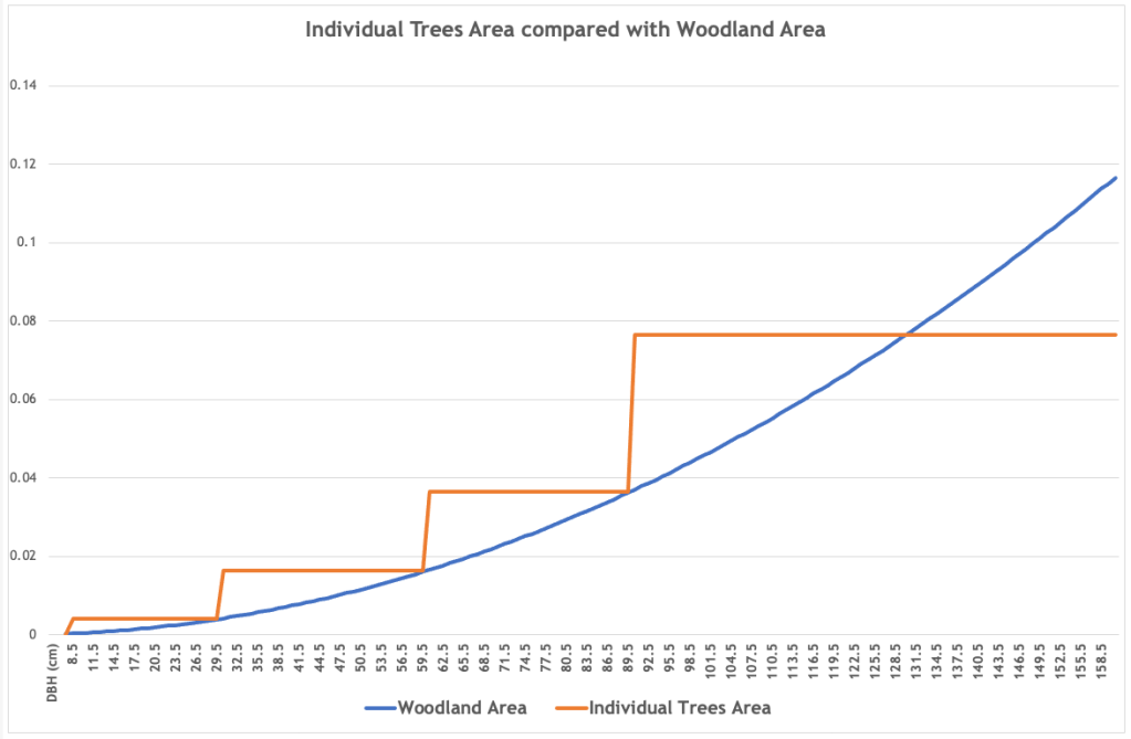
As a result, this approach places a higher value on the areas of all but the largest Individual trees habitats than those that form part of a Woodland and forest habitat. The following graph shows this, with RPA, derived from DBH, representing the canopy biomass of both broad habitats.
We analysed 12 recent planning applications involving 2,116 trees, 612 (29%) of which were identified for removal. Using the Metric User Guide, they have a combined habitat area of 20.2 ha. If they are measured by canopy area it would only be 8.3 ha (41% of their habitat size). If their combined Root Protection Areas (RPA) were used, they would cover only 8.6 ha (43% of their habitat size).
On the basis that all these trees are in poor condition and have no strategic significance, we calculate that, with the minimum 10% biodiversity net gain now required, a total of 1,925 new trees would need to be planted to replace the habitat lost by the removal of these 612 tree – a ratio of just over 3:1.
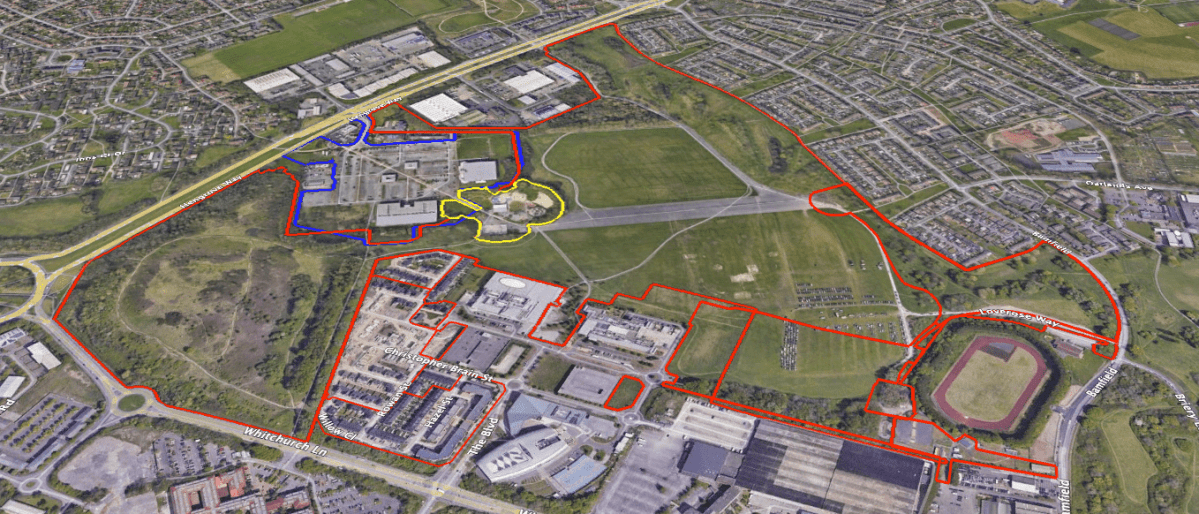
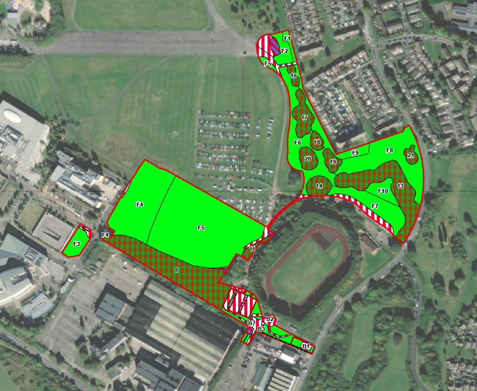
To illustrate how this can affect actual applications, here’s a pending application by Goram Homes at Hengrove Park in Bristol. The area edged in red is the development site.
This next image shows how the applicant’s ecologists have defined each habitat: the woodland and forest habitats are shown as a diamond pattern on a dark green background. They cover 2.44 ha.
They’ve also identified 0.19 ha of Individual trees habitat, that is, trees not growing within the woodland and forest habitats.
Area 8 in the south of the site (0.99 ha) might legitimately be designated Woodland and forest habitat, but, given that all the remaining trees are growing separately and in groups in an urban park, they should be designated UrbanIndividual tree habitat.
The site is complex, with many trees growing in groups but, by excluding the trees in area 8 and treating all the other onsite trees as UrbanIndividual tree habitat, we calculate that their habitat area is 6.42 ha. This is 4.78 ha more than the applicant’s calculation. This difference will clearly have a significant impact on the final biodiversity net gain calculation, valuing these habitats at 34.07 area habitat units (or 2,989 Small size trees) as opposed to the applicant’s 12.11 (or 1,063 Small size trees).
To give the applicant their due, they at least attempted to calculate the tree habitat area. We have seen other applications where the trees were simply ignored, or were classified as another habitat – bramble scrub in one case, or the method by which the Individual trees habitat area was calculated bore no relationship to the evidence submitted. We must remain ever vigilant against such tricks.
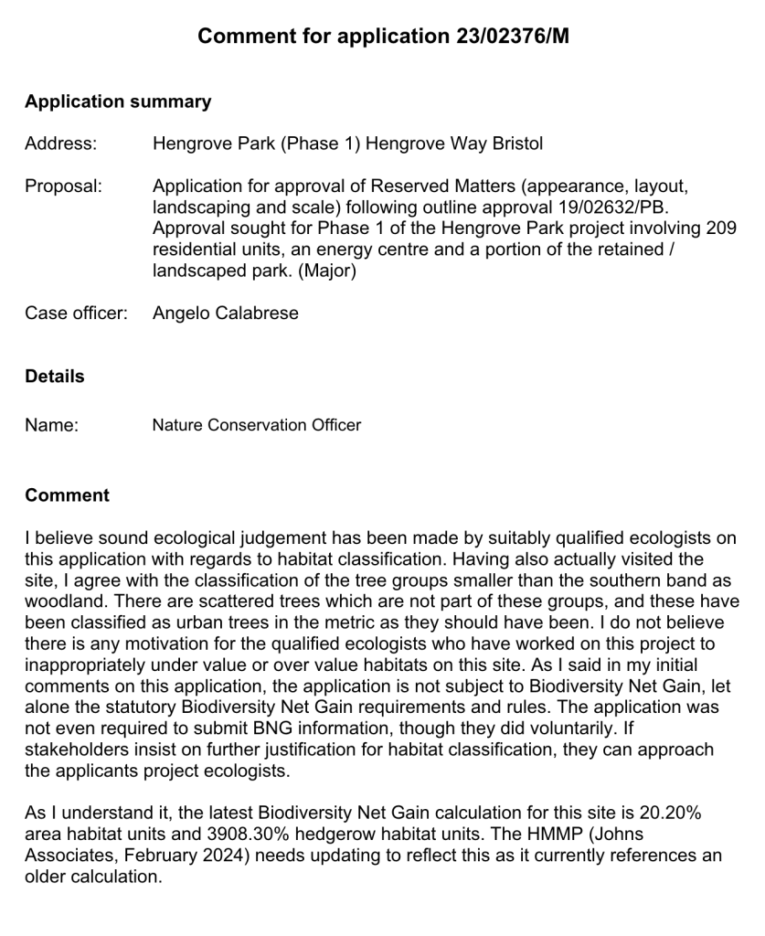
This blog was amended on 09 May 2024 to include the comments of the Nature Conservation Officer dated 03 May 2024 about whether the trees on the Hengrove Park development site are Individual trees habitat or Woodland and forest habitat. The officer writes:
This blog was amended on 14 February 2024 following the obligation for most planning applications to achieve at least 10% biodiversity gain becoming obligatory on 12 February 2024.
Further changes have been made following updates published in July and August 2024, in particular the clarification of the application of BNG in private gardens.
We believe the time has come to revise the Bristol Tree Replacement Standard (BTRS), to reflect our changing understanding of the vital importance of urban trees to Bristol and how they contribute to biodiversity gain.
The current BTRS Standard, adopted nearly a decade ago in July 2014, provides a mechanism for calculating the number of replacements needed for any trees that are removed for developments. It was ground-breaking in its time as it, typically, required more than 1:1 replacement of trees lost to development.
Since then, Defra has published the statutory version of the Biodiversity Metric (SM) (on 29 November 2023), which became mandatory on 12 February 2024. In addition, Bristol has adopted Climate and Ecological Emergency Declarations, so an updated BTRS would be an important part of implementing these declarations. It would require all new developments, subject to some exceptions, to achieve a Biodiversity Net Gain (BNG) of at least 10%. Where developments are exempt, BTRS will still apply.
Although Councillors rejected our proposals for a new Standard at their meeting on 31 October last, we’ve revisited our July 2023 proposals and recast our calculations. These proposals, set out below, provide a mechanism for complying with the new requirements and align the BTRS with the BNG provisions of the EA 2021.
The purpose of the BTRS is that it should only ever be a last resort and not the default choice – which, unfortunately, it has become. When considering any development involving established trees, the presumption should always be that trees will be retained. If this is not possible, then the impact of the proposed development must be mitigated. Only if this is impossible, should compensation for their loss be considered. This is the meaning of the Mitigation Hierarchy, as set out in paragraph 180 a) of the National Planning Policy Framework, which states:
If significant harm to biodiversity resulting from a development cannot be avoided (through locating on an alternative site with less harmful impacts), adequately mitigated, or, as a last resort, compensated for, then planning permission should be refused.
This is reflected in the Bristol Core Strategy, policy BCS9(page 29),which states that:
Individual green assets should be retained wherever possible and integrated into new developments.
This is repeated in the proposed replacement for BCS9 – Policy BG1: Green infrastructure and biodiversity in new development(page 124) – which ‘aims to ensure that green and blue infrastructure and provision for nature is incorporated into new development’ so that, among other things:
The provision of green infrastructure in new development should … Retain and incorporate important existing green infrastructure such as trees (Policy BG4 ‘Trees’), hedgerows and water features …
It is a shame that the requirement is only an aspiration, not an obligation.
Background
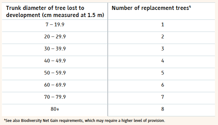
Under the new proposed policy – BG4: Trees (page 131) – trees lost to development will be replaced using this table:
Table 1 The proposed BG4 tree replacement table.
However, when the balance of EA 2021 takes effect, the current version of the BTRS will not, in most cases, be enough to achieve the 10% BNG minimum required for nearly all developments. A new Section 90A and Schedule 7A will be added to the Town and Country Planning Act 1990 and will set out the level of BNG required.
Under the statutory framework for biodiversity net gain, subject to some exceptions, every grant of planning permission is deemed to have been granted subject to the condition that the biodiversity gain objective is met (“the biodiversity gain condition”). This objective is for development to deliver at least a 10% increase in biodiversity value relative to the pre-development biodiversity value of the onsite habitat. …
Many development proposals will aim to achieve more than the minimum 10% gain voluntarily. Others may not but will still need to achieve much more in order to comply with the SM trading rules (page 140). This is based on the habitat type lost and its distinctiveness. In the case of Individual tree habitats – Urban or Rural – losses must be replaced within the same broad habitat (i.e. more Individual trees) or with a habitat of a higher distinctiveness.
However, for the sake of certainty, we propose only using the minimum 10% BNG required.
Our proposed new BG4 (BTRS) model
We propose that the table in BG4 be amended to reflect the requirements of the EA 2021 and SM and that the BG4 table (Table 1 above) be replaced with Table 2 below:
Table 2 Our proposed BG4 tree replacement requirement
The Replacement Trees Required number is based on the habitat area of each of the four SM tree category sizes (Table 13 below), divided by the area habitat of one BNG 4.0 Small category tree (see section 3 below) plus a 10% net gain. This is rounded up to the nearest whole number (since you can’t plant a fraction of a tree).
The reasoning for our proposal is set out below:
1. Applying the Biodiversity Metric to Urban trees
Use the broad habitat type ‘Individual trees’ to record trees where:
they are found as an individual or as part of a group;
are over 7.5cm in diameter at breast height (DBH).
Individual trees should also be recorded where they meet the definition of an irreplaceable habitat but would not otherwise be recorded.
Do not otherwise record individual trees if they occur within an area habitat type characterised by the presence of trees, examples of these are:
woodlands
orchards
wood-pasture and parkland
Individual trees are classed as ‘urban’ or ‘rural’. You should consider the degree of ‘urbanisation’ of habitats around the tree and assign the best fit for the location.
2. Calculating Individual trees habitat
Table 13 in the SM User Guide is used to calculate the ‘area equivalent’ of individual trees:
The biodiversity metric uses set values to represent the area of trees depending on their diameter at breast height. This value is a representation of canopy biomass, and is based on the root protection area formula, derived from BS 5837:2012.
You should report the number of individual trees within your project and input tree count into the ‘tree helper’ within the biodiversity metric tool to generate area values for data input. For multi-stemmed trees, use the DBH of the largest stem. You should:
account for each individual tree within a group or block of trees.
record the habitat underneath the tree canopy separately.
not reduce any area generated by the tree helper.
not deduct the area of individual trees from other habitats.
make clear in the user comments how many trees contribute towards the total area.
Recording trees within private gardens
You should assess most individual trees that are recorded in private gardens. You should record:
any medium, large and very large trees as individual trees
any small trees that are ancient or veteran
Recording trees within hedgerows
You should assess most individual trees that are recorded within hedgerows. You should record:
any medium, large and very large trees as individual trees
any small trees unless they are ancient or veteran.
You must assess the linear value of hedgerows within the hedgerow module separately.
Individual Tree habitats have medium distinctiveness and so, under Rule 1 of SBNG, ‘Losses must be replaced by area habitat units of either medium band habitats within the same broad habitat type or, any habitat from a higher band from any broad habitat type.’
3. Forecasting the post-development area of Individual trees
The SBNG User Guide provides this guidance:
You should use the tree helper to calculate the area for created trees.
You should categorise most newly planted individual trees as ‘small’, unless the tree is medium sized or above at the time of planting.
You should not factor in the age of nursery stock when using the ‘creation in advance’ function. The ‘creation in advance’ function should only be used where trees are planted in advance of the development (for example, as screening or as structural landscaping).
Exceptions
You cannot count:
newly planted trees within private gardens
natural size increases of baseline trees
trees planted as part of hedgerow creation or enhancement as individual trees.
Our calculations are based on Small category replacement trees being planted as per the SM guidance.
4. The likely impact of this policy change
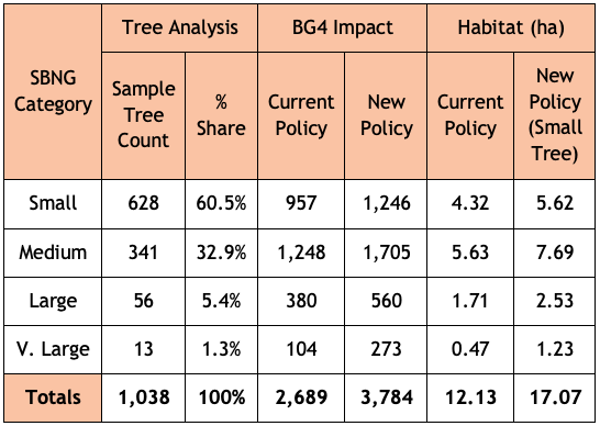
We have analysed tree data for 1,038 surveyed trees taken from a sample of BS:5837 2012 tree surveys submitted in support of previous planning applications. Most of the trees in this sample, 60.5%, fall within the SM Small tree category, 32.9% are within the Medium tree category, 5.4% are in the Large tree category with the balance, 1.3%, being categorised as Very Large.
Table 4 below sets out the likely impact of the proposed changes to BG4. It assumes that all these trees were removed (though that was not the case for all the planning applications we sampled) and replaced with SM Small category trees:
When the Development Control Committee last met to discuss the Council’s application to extend the cemetery at South Bristol into the SNCI at Yew Tree Farm on 6 September 2023, we were disturbed to hear the Chief Planner’s interpretation of the meaning of ‘harmful impact’, as set out in the Local Plan policy, DM19 – ‘Development which would have a harmful impact on the nature conservation value of a Site of Nature Conservation Interest will not be permitted.’
As we received no reply at the time, we took the opportunity to ask again when the Committee reconvened to make its decision on 29 November 2023. We asked two questions – see page 9 of the Public Forum. As the responses still didn’t really satisfy, we asked two supplementary questions:
When you say, ‘the site’, what do you mean? Is it within the redline boundary or something else such as within the SNCI’s boundary?
You say ‘The crucial additional clarification to highlight, is that to be in alignment with this policy it is NOT the overall biodiversity gain that is determinative. There rather needs to be an assessment that establishes whether there is harm with reference to the specific characteristics that make the site special.’
Does this mean that the replacement of one habitat which forms part of the ‘specific characteristics that make the site special’ – such as a replacing the Grassland Habitat that forms part of the current SNCI designation with a Lake Habitat that does not form part of the current SNCI designation, or that the provision of offsite mitigation measures to compensate for onsite habitat losses (in this case -6.44%) – would not be acceptable?
These were the replies:
To question 1
By ‘the site’, it’s the site as set out in the application document, so it’s the SNCI as contained in the application document the area in the redline boundary.
To question 2 (as it is quite complex, we have reproduced it verbatim)
You need to take the application as a whole and where it is demonstrated as that with regard to the features, particularly the grassland, that there is no impact ultimately or, if anything, a slight enhanced impact.
We intervened to ask – So you are saying that the substitution of the grassland habitat for a lake habitat…?
I am not saying that at all, I am saying that the grassland, actually that there is more grassland and that’s what the ecology report also says – more grassland of the type for which the SNCI is designated will be there through this application than before… within the redline boundary.
Anyone who wants to develop land must produce a location plan of the area proposed for development, delineated by a red line – the so-called ‘redline boundary’.[1]
When planning permission is granted, only the area within the redline boundary may be developed (though ancillary works may take place elsewhere).
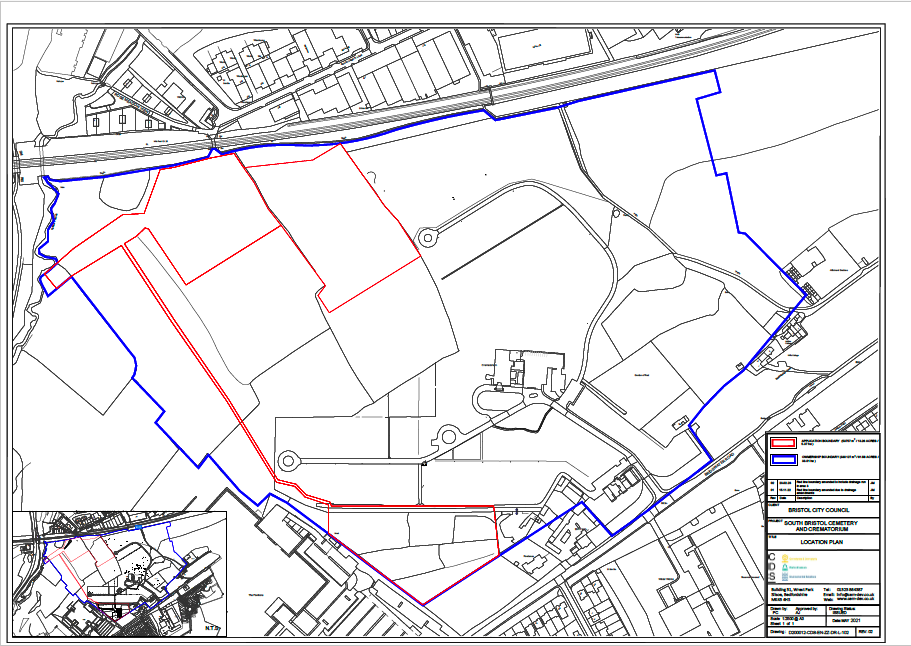
Here is the location plan for the South Bristol Cemetery Extension application:
The South Bristol Cemetery Extension location plan (North is at the top)
The redline boundary here is quite complex because it’s made up of two burial areas, in the north and south, and an attenuation pond to collect runoff from the northern burial ground through a series of drains (the southern burial ground runoff will drain straight into Colliter’s Brook to the west). The area within the blue line is also owned by the Council and so is under their control.
The redline boundary is also important when it comes to calculating the biodiversity value (BNG) of the development site. All the habitats within the redline boundary are treated as ‘onsite’, while those outside the boundary are treated as ‘offsite’.
So, when we are told that ‘… there is more grassland and that’s what the ecology report also says – more grassland of the type for which the SNCI is designated will be there through this application than before… within the redline boundary,’ it’s just the onsite area that’s being referred to. This is important, as we show below.
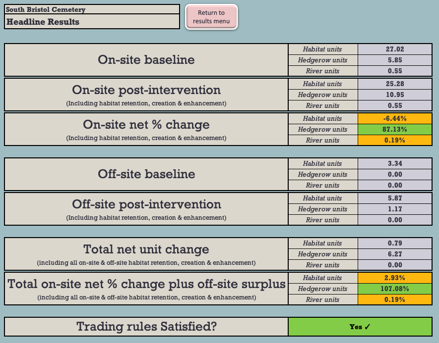
The headline results shown in the most recent BNG 3.1 calculation relied on by the Council[2] show that 6.44% of the baseline onsite area biodiversity will be lost as a result of the development (see Figure 1).
Figure 1: The BNG 3.1 Headline BNG results.
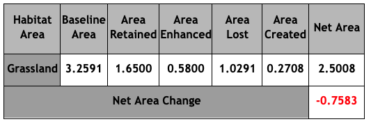
Figure 2 shows the net losses of the onsite grassland habitat:
Figure 2: Grassland Area & Habitat Unit analysis (HUs)
Under the BNG Trading Rules, Medium Distinctiveness grassland habitats may only be replaced with the other Medium Distinctiveness grassland habitats or with habitats of a Higher Distinctiveness. So, in order to achieve the net 2.93% BNG which the Council claims will result from the development, it will be necessary to compensate for these losses by crediting 3.25 Habitat Units of High Distinctiveness Lakes habitat by creating the attenuation pond.
This is not what we are told is happening and it certainly cannot be said that: ‘… there is more grassland … of the type for which the SNCI is designated … within the redline boundary,’ This is plainly untrue and, even on the Chief Planner’s definition (which we do not accept), it is clear that this application will ‘have a harmful impact on the nature conservation value of a Site of Nature Conservation Interest.’ This is contrary to DM19.
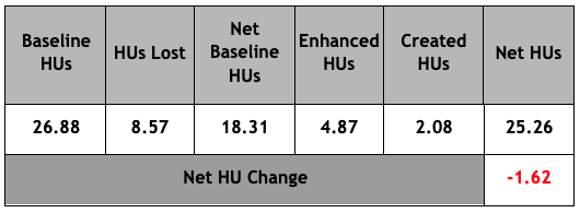
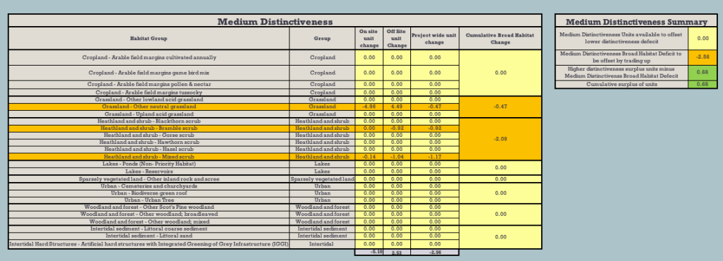
What’s more, even if the proposed offsite habitat mitigations were taken into account, there’d still be a net loss of -0.47 HU of Medium Distinctiveness grassland habitat (see Figure 4 below).
Figure 4: Net Medium Distinctiveness habitat losses
There’s one other serious flaw in the application, which was not brought to the attention of the Development Control Committee at its meeting. There’s a shortfall of -0.11 Habitat Units of the High Distinctiveness habitat, Species-rich native hedgerow with trees. Lost High Distinctiveness habitats may only be replaced like-for-like. This has not happened. As a result, the application is in breach of the BNG Trading Rules and should not have been approved.
We have brought this to the attention of the Council and the LPA.
These are just some of the important reasons why we say that the Development Control Committee was wrong to grant this flawed application.