
“Bristol ranks as the 5th greyest city in England”
This statement was made in a recent article in Wales Online, the Express, and elsewhere. The article, with a by-line of Neil Shaw, seems to be based on a press release by OVO Energy who are promoting a petition to create a legally binding target to plant 30,000 ha of new woodland each year to 2050. The article reported tree cover in a number of countries and cities around the UK based on data supplied by the aerial survey and GIS company BlueSky. Amongst the results is :
Bristol, known for its green credentials, ranks as the 5th greyest city in England at 8% – and only 1 tree per person.
This is very different from the estimate produced by our own tools which estimate tree canopy cover (TCC) in 2020 at around 17.5%. Thankfully, as the following analysis discovers, Bristol can hold its head as a green city.
i-Tree Canopy
Our estimate is based on a desktop survey using a methodology called i-Tree Canopy. The methodology is pretty simple: take any boundary, randomly place a number of points within the boundary, examine each point in Google Maps and decide if the point lies within a tree canopy or not; the ratio of canopy points to the total number of points is the TCC, Uncertainty arises from the nature of the random sampling and interpretation of the image, particularly to distinguish a tree from hedges and low ground cover.
Our version of this approach is integrated with the Trees of Bristol website so that it can used to estimate TCC for any area in our database with a known boundary. In particular, we have used this tool to estimate TCC for all wards in Bristol which are mapped here. These values have joined the many hundreds of estimates across the UK to form the GB Ward Canopy Map organised by Forest Research. With this pedigree, we have been advocating this approach for use in Bristol as the means to assess progress towards Bristol’s ambitious goal of doubling tree canopy by 2046. Aggregating the samples across all 32 wards, we estimated that Bristol had 17.9% TCC in 2018 and by 2020 it was 17.5%. (This change from 2018 to 2020 is not statistically significant)
National Tree Map
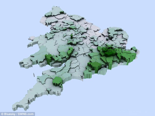
The estimates in the press article were based on the National Tree Map, a commercial product from Bluesky. This uses a combination of their own imagery and LIDAR data. Complex analysis of the LIDAR data, using the difference in return time from ground and canopy reflections enables an estimate of the canopy above 3m high.
Discussion with Bluesky revealed a probable cause of the discrepancy for Bristol. Any comparison between estimates needs to be based on the same boundary definition using imagery from the same time period. For the i-Tree Canopy approach we have used the City of Bristol boundary which has an area of about 11,000 hectares (110 sq km) . In contrast, it turns out that the data provided to OVO energy by Bluesky was based on the Unitary Authority Boundary. For Bristol this is a rather odd area, taking in a swath of the Bristol Channel down as far as the islands of Flat Holm and Steep Holm. This is because historically, the boundary of the Port of Bristol is included.
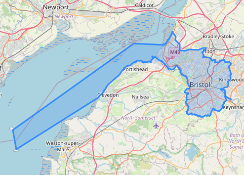
The area within this boundary is 23,500 hectares. Since Bristol can hardly be criticised for failing to plant trees in the Bristol Channel, this dramatically distorts the estimate. Adjusting for this difference in definition, I arrived at a figure of 17%, within the statistical bounds of the i-Tree canopy estimate.
The National Tree map was also used back in 2014 as reported in the Daily Mail. The accompanying map similarly shows a very low value for tree canopy in Bristol so I suspect that the same boundary was used there too.
Comparison
After discussion with BlueSky, I supplied four boundaries for assessment using the NTM methodology for comparison with the i-Tree approach: the Bristol City Boundary and three wards chosen to have low, medium and high levels of canopy. These are the results:
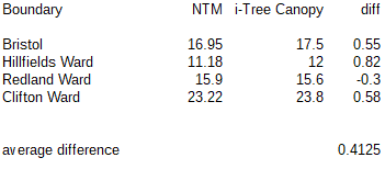
NTM uses a strict height of 3 metres when assessing canopy whereas using i-Tree canopy, the distinction between tree canopy and lower greenery including hedges is assessed visually, so a slight upward bias might be expected and has also been observed in Forest Research data. On the whole though, this comparison shows very strong agreement between the two methodologies.
The bad news
The gross error in Bristol’s tree canopy percentage actually made it easy to see that something was amiss. One must assume that similar issues will have occurred in the case of other cities whose boundaries are subject to debate. Indeed, the Unitary authority boundary for Portsmouth, which with only 4% cover is reported to the be worst in the UK, includes the expanse of Portsmouth and Langstone Harbours. According to the Portsmouth Council website, land is about two-thirds of the area of the authority so a better figure would be 6%, still low.
Problems with boundary definitions plague this data. Bristol City is only the core of the conurbation with large parts of what we think of as Bristol in South Gloucestershire and Bath and North East Somerset. Comparison with the figure given for Leeds, also 17%, is not possible since the City of Leeds boundary includes all the surrounding towns and countryside.
It is clear that unitary authority boundaries are not directly suitable for urban canopy evaluation.
The need for full data publication
In addition to the 2014 report and the recent publicity by Ovo Energy, another survey by Bluesky was publicised late last year on the BBC but no figure for Bristol is mentioned. These press articles give only selective figures rather than the full data across England. I searched for published reports containing the full data, which I expected to include the base area, canopy area as well as the computed percentage and rankings. I found nothing. This makes it impossible to correct other derived data, such as the ranking of Bristol as the “5th greyest in England”.
I would hope that in future, companies like Bluesky and Ovo Energy will see that making full data openly available in support of extracts and assertions would reduce mis-interpretations, provide a public good and better promote their company.
Journalists too have a responsibility here, not only to critically assess press releases but to request and link to the supporting data. Neither happened in this case.
The good news
This exercise has turned out to be good news for both the National Tree Map methodology and our own work with i-Tree Canopy. The results are very similar and differences are rather consistent and explainable. Our implementation of i-Tree Canopy is free to use by citizen-scientists with known error bounds and can be quickly applied to any chosen boundary. With the inclusion of historical imagery from Google Earth, it can also be used to compare canopy over time.
This exercise has also confirms the doubts we held about the figure from an i-Tree Eco survey carried out in 2018. This survey used volunteers to ground-survey 200 random plots in Bristol. The survey arrived at a figure of 12% with wide error bounds but much less than the i-Tree Canopy value. All methods have some uncertainty but we can be pretty confident that Bristol’s Tree Canopy in 2020 is in the region of 17 – 18%.
The National Tree Map is primarily intended as a means to locate and measure the canopy of individual trees in an area. The canopy estimate is only a by-product and agrees well with the i-Tree canopy approach. For its primary purpose, NTM appears to provide a very much more economic solution than on the ground surveying. Indeed it would be very interesting to compare this map for Bristol with the mapping of individual trees in Trees of Bristol.
Forest Research is at the forefront of research into the UK Urban Tree canopy and their 2017 paper on the Canopy Cover of Englands Towns and Cities remains the most authoritative UK -wide survey. We look forward to an update to this excellent work.
Chris Wallace
First published in The Wallace Line on 11 May 2021

One thought on “Bristol’s Tree Canopy”