St Philip’s Marsh: do the green space sums add up?

Bristol’s biggest regeneration plan promises parks within a five-minute walk of every front door. We measured the plan’s own drawings to see whether the promise holds. Here’s what we found.

St Philip’s Marsh is about to become the new place in Bristol to live, work and study. The draft Masterplan, created by the Bristol Temple Quarter Partnership is now out for consultation. It proposes at least 7,000 homes — for roughly 15,000 people — on 94 hectares of old industrial land east of Temple Meads, plus workspace for thousands of jobs and student housing beside the university’s new campus. For an area with almost no publicly accessible green space currently, the Masterplan’s vision of parks, green streets and riverside walks is most welcome, and we want it to succeed.

However, when we measured the plan’s own drawings — every park, square and green corridor, checked against the Council’s own GIS records — the numbers put forward started to wobble.


A table that vanished

The Masterplan’s headline is 22.4 hectares of open space and green corridors, including 8.1 hectares of ‘new open space’. Curiously, the published figure that should show this breakdown contains no numbers at all. The arithmetic survives only in the figure’s hidden accessibility text — the description read aloud by screen readers. This refers to a quantification table ‘overlaid on the side of the plan’. However, this table was removed before publication, and nobody has updated the hidden text. Our own measurements confirm the totals are correctly computed. So why take the table out?


How big is Sparke Evans Park? Pick a number

The document gives three different sizes for the area’s only existing park, Sparke Evans Park: 2.9 hectares in the body text, 2.5 in the hidden arithmetic, and 2.34 as drawn. The Council’s own GIS records 2.3416 ha. A small thing, perhaps — but the body text overstates the park by 24%, which is the baseline everything else is measured from.

A bigger question is how large is the site itself? The Masterplan never says. Its drawn boundary encloses 94 hectares but the council’s investment website says St Philip’s Marsh totals 65 hectares. Nobody reconciles the two. This is important as the site area is the denominator for the plan’s flagship promise of 25% tree canopy. 25% of which number?


What actually counts as a park?

Bristol’s Parks and Green Spaces Strategy is clear that ‘public realm’ — squares, promenades, landscaped frontages — does not count as open space for recreation. Strip those out of the Masterplan’s 8.1 hectares and the qualifying provision shrinks to somewhere between 5 and 6.6 hectares, most generously counted — and only around 2.6 to 4.3 hectares of it is new. The real new parks are two: Chapel Park (1.26 ha) and Fruit Market Park (about 1.3–1.5 ha). Each is roughly the size of College Green. Between them and Sparke Evans Park, they are expected to host school play, neighbourhood events, ecology, gardens and the daily recreation of thousands.


The density arithmetic nobody has published

Bristol’s adopted standard for the city centre zone is 7.75 m² of recreational open space per person — itself barely a quarter of the 33 m² the average Bristolian enjoys citywide. Working through the strategy’s published figures shows that standard has been set with zero headroom: it assumes the central area’s population will rise 65%, offset by just 2.9 hectares of new green space, landing exactly on the 7.75 m² standard adopted.

The St Philip’s Marsh residents will get roughly 3.3 to 4.4 m² of qualifying green space per person on site, about one tenth of the citywide average. And that’s before you include the daytime population, who will share the same spaces: a workforce of 5,000 or more, several thousand students, and those whom the plan rightly invites in, living nearby in The Dings, Barton Hill, Totterdown and Redcliffe — some of the most green-space-deprived communities in Bristol. If the Masterplan’s population exceeds what the strategy assumed — and its unpublished assumptions are a question we’ve put to the Council — the adopted standard is breached simply by the arithmetic.


Five-minute-walk — from the front door, or the tenth floor?

We modelled walk times over the plan’s own street network. The average journey to the nearest named park is about three minutes. This supports the five-minute-walk promise. However, with roughly one in five residents living above the fifth floor in residential towers of ten storeys and more, this will add to the walk time just getting to the ground before setting off. For those households the five-minute promise quickly becomes longer. Sparke Evans Park, in the south-east of the site, is up to 21 minutes from the far north-west corner, while parts of the employment area are 7–10 minutes from any named park.

And five minutes for whom? The plan’s promise assumes a brisk walker covering 400 metres in five minutes. Bristol’s own parks standard describes that same 400 metres as a nine-minute walk — the pace of older people, small children, anyone with a buggy or those whose walking is impaired: exactly the people who parks matter most for. At that pace, every estimate above roughly doubles, and the far corner of the site is nearly 40 minutes from Sparke Evans Park. The five-minute-walk promise is really a 400-metre promise — which should be judged at the speed of the slowest, not the fastest.


Three thousand trees, ready by the 2050s?

The 25% canopy pledge needs 16–19 hectares of new tree canopy: in the order of 3,000 trees. These will largely be planted on streets that must also fit cycleways, drainage and utilities — creating a near-continuous tree ceiling over two-thirds of the public realm. Newly planted trees would deliver under 1% of site canopy on day one and take 25–40 years to mature, on top of the 20 years needed to complete the development. The 25% canopy pledge currently has no target date, no baseline and no monitoring. So for the first couple of decades, a resident on, say, the tenth floor will look down on saplings, not canopy — exactly what the international 3/30/300 benchmark (3 visible trees, 30% canopy, green space within 300 m) aims to prevent.


What we’re asking for

Our submission makes a series of specific requests, including:

  1. Correct the ambiguous reported park sizes.
  2. Reinstate the vanished quantification table.
  3. State the definitive site area and publish the boundary as open GIS data.
  4. Publish a schedule of open space that distinguishes real recreational space from public realm space, and test this against the projected full daytime population.
  5. Publish the population assumptions behind the quantity standard.
  6. Put a date, baseline, funding and monitoring regime on the canopy pledge.
  7. Front-load tree planting.
  8. Adopt 3/30/300 at design-code stage.
  9. Explain how and when the riverside open spaces will be delivered, given their dependency on the Avon Riversides 2100 flood defence programme — for which £88m has been identified against a further £128m still required.

None of this requires redrawing the plan. It just requires the Partnership to show its workings — because on green space, the difference between a promise and a number is where communities lose out, one planning application at a time.

One last thing. This document was meant to be a Supplementary Planning Document — statutory guidance sitting alongside the Local Plan. A change in Government regulations earlier this year means it will now be adopted only as an “endorsed Masterplan”: non-statutory guidance that developers must merely “have regard to”. That makes everything above more fragile, which is why our submission also asks for the green space framework to be secured through Local Plan policy wording, where it will have legal force.

The consultation closes on 28 July 2026. You can respond through the council’s survey or by emailing: hello@bristoltemplequarter.com — and if green space in this new piece of Bristol matters to you, please do.


Read our submission, with methods and maps, here:

SPM Masterplan Consultation – BTF Response

Analysis for this submission included independent measurement of the Masterplan’s Figure 07.34, georeferenced against Bristol City Council GIS data, and walk-time modelling over the illustrative street network, carried out with AI assistance (Claude, Anthropic) under our direction. Methods are set out in full in the submission’s annex.
Our proposal for a new Bristol Tree Replacement Standard

The Bristol Tree Replacement Standard (BTRS), which was adopted nearly a decade ago in 2013, provides a mechanism for calculating the number of replacements for any trees that are removed for developments. It was ground-breaking in its time as it typically required more than 1:1 replacement.

The presumption should always be that trees should be retained. The application of BTRS should only ever be a last resort. It should not be the default choice, which it seems to have become.

The starting point for any decision on whether to remove trees (or any other green asset) is the Mitigation Hierarchy[2] which states, firstly, avoid; then, if that is not possible, minimise; then, if that is not possible, restore; and, as a last resort, compensate (the purpose or BTRS). BCS9 adopts this approach and states that:

Individual green assets should be retained wherever possible and integrated into new developments.

However, with the emergence of a new Local Plan for Bristol, we believe that the time has come for BTRS to be revised to reflect our changing understanding of the vital importance of trees to the city in the years since the last version of the Local Plan was adopted in 2014.

In addition, Bristol has adopted Climate and Ecological Emergency Declarations so a new BTRS will be an important part of implementing these declarations. Nationally, the new Environment Act 2021 (EA 2021) is coming into force late next year.

Our proposal provides a mechanism for complying with the new legal requirement for 10% Biodiversity Net Gain (BNG) which will be mandatory when EA 2021 takes effect.

Background

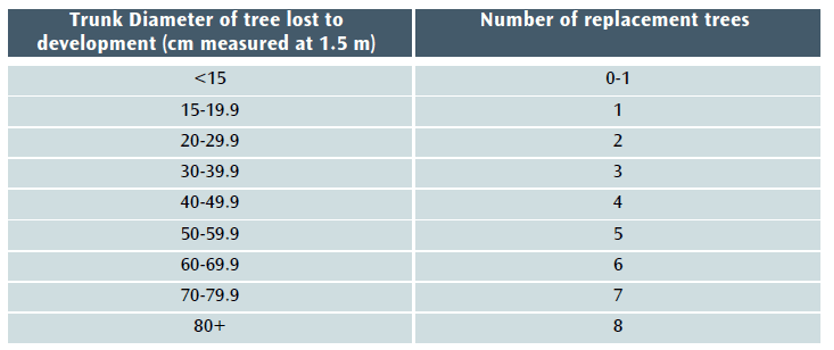
Under current policy – BCS9 and DM17 – trees lost to development must be replaced using this table:

Table 1 The Current BTRS replacement tree table

However, when the balance of the Environment Act 2021 (EA 2021) takes effect late in 2023, the current version of BTRS will not, in most cases, be sufficient to achieve the 10% biodiversity net gain (BNG) that will be required for nearly all developments. Section 90A will be added to the Town and Country Planning Act 1990 and will set out the level of biodiversity net gain required ( Schedule 14 of the EA 2021).

The Local Government Association says of BNG that it:

…delivers measurable improvements for biodiversity by creating or enhancing habitats in association with development. Biodiversity net gain can be achieved on-site, off-site or through a combination of on-site and off-site measures.[3]

GOV.UK says of the Biodiversity Metric that:

where a development has an impact on biodiversity, it will ensure that the development is delivered in a way which helps to restore any biodiversity loss and seeks to deliver thriving natural spaces for local communities.[4]

This aligns perfectly with Bristol’s recent declarations of climate and ecological emergencies and with the aspirations of the Ecological Emergency Action Plan,[5] which recognises that a BNG of 10% net gain will become mandatory for housing and development and acknowledges that:

These strategies [the Local Nature Recovery Strategies] will guide smooth and effective delivery of Biodiversity Net…

Our proposed new BTRS model

We propose that the Bristol Tree Replacement Standard be amended to reflect the requirements of the EA 2021 and BNG 3.1 and that the BTRS table (Table 1) be replaced with Table 2 below:

Table 2 The proposed new BTRS tree replacement table

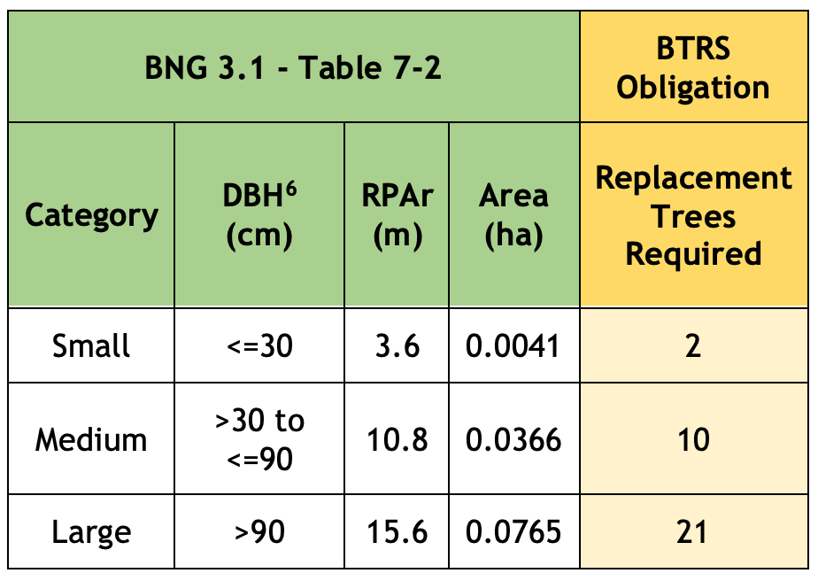
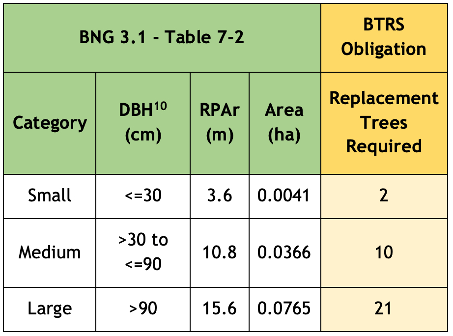
The Replacement Trees Required number is based on the habitat area of each of the three BNG 3.1 tree categories (Table 7-2 below) divided by the area habitat of one 30-year old BNG 3.1 Small tree (Table 3 below) plus 10% net gain. This is rounded up to the nearest whole number since you can’t plant a fraction of a tree.

The reasoning for our proposal is set out below:

Applying the Biodiversity Metric to Urban trees

The most recent Biodiversity Metric (BNG 3.1) published by Natural England, defines trees in urban spaces as Urban tree habitats. The guidance states that:

the term ‘Urban tree’ applies to all trees in urban situations. Urban trees may be situated within public land, private land, institutional land and land used for transport functions.

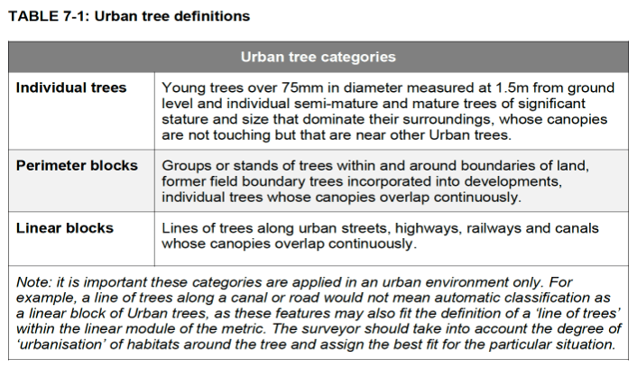
Table 7-1 divides Urban tree habitats into three categories:

Paragraph 8.5 of the 3.1 BNG Guidance makes it clear that lines of trees in an urban environment should not be treated as a linear habitat:

Urban trees are considered separately to lines of trees in the wider environment, since they generally occur in an urban environment surrounded by developed land. 

Calculating Urban tree habitat

Urban tree baseline habitat area is measured in hectares and is based on the Root Protection Area[7] (RPA) of each tree impacted by a proposed development. RPA is used instead of tree canopy because it is considered to be the best proxy for tree biomass.

In most cases, RPA is obtained from an Arboricultural Impact Assessment (AIA), which complies with British Standard 5837 2012 – Trees in relation to design, demolition and construction (BS:5837).

Where no AIA is available, Table 7-2 is used:

Note that the tree’s size will still need to be ascertained, and that any tree with a stem diameter (DBH) 75mm or more and of whatever quality (even a dead tree, which offers its own habitat benefits) is included . Under BTRS, trees with a DBH smaller than 150 mm are excluded, as are BS:5837 category “U” trees.

The guidance also makes it clear that, given the important ecosystem services value provided by trees, where possible like-for-like compensation is the preferred approach, so that lost Urban trees are replaced by Urban trees rather than by other types of urban habitat.[8]

Replacing lost trees

To calculate the number of trees required to replace Urban tree habitat being lost, table 7-2 above is used on this basis:

Size classes for newly planted trees should be classified by projected size at 30 years from planting.

We have used the median DBH sizes for new stock trees as set out in BS 3936-1: Nursery Stock Specification for trees and shrubs as the basis for calculating the eventual size of a newly planted trees after 30 years and assumed that a tree adds 2.54 cm (1”) to its girth annually.

This results in a predicted stock tree size after 30 years’ growth. This is then assigned to one of the three Urban tree categories set out in table 7-2: Small, Medium or Large. In all cases save for Semi-mature tree stock, the eventual size of stock trees after 30 years falls within the BNG 3.1 size category Small, which has a habitat area of 0.0041 hectares. This value is then used to calculate how many new trees will be required to replace trees lost to the development, plus a 10% biodiversity net gain. This gives a compensation size per replacement tree of 0.0045 ha (0.0041 hectares + 10%).

Table 3 below shows the basis our our calculation:

Table 3 Annual stock tree growth predictions

The Trading Rules

It may be that a notional positive biodiversity net gain can be achieved by replacing fewer trees than this analysis indicates. However, this is not enough. The calculation should also comply with the Trading Rules that apply to Urban tree habitats.

Paragraph 7.6 of the 3.1 BNG Guidance states:

The mitigation hierarchy and trading rules apply to Urban trees. Given Urban trees are a ‘Medium’ distinctiveness habitat, trading rules stipulate that the same broad habitat type (or a higher distinctiveness habitat) is required. However, given the important ecosystem services value provided by trees, where possible ‘like for like’ compensation is the preferred approach (i.e. where possible any loss of Urban trees should be replaced by Urban trees – rather than other urban habitats).

Rule 3 of the User Guide states: ‘”Trading down’ must be avoided. Losses of habitat are to be compensated for on a ‘like for like’ or ‘like for better’ basis. New or restored habitats should aim to achieve a higher distinctiveness and/or condition than those lost…’

The likely impact of this policy change

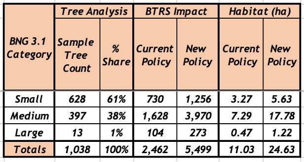
We have analysed tree data for 1,038 surveyed trees taken from a sample of AIAs submitted in support of previous planning applications. Most of the trees in this sample, 61%, fall within the BNG 3.1 Small range, 38% within the Medium range, with the balance, 1%, categorised as Large.

Table 4 below sets out the likely impact of the proposed changes to BTRS. It assumes that all these trees were removed (though that was not the case for all the planning applications we sampled):

Table 4 Proposed BTRS impact analysis

The spreadsheet setting out the basis of our calculations can be downloaded here – RPA Table 7-2 Comparison.

Our proposed changes to BTRS (published in the Planning Obligations Supplementary Planning Document, page 20) are set out in Appendix 1.

This article was amended on 7 November 2022 to include references to Lines of Trees in the urban environment, the application of the Trading Rules to Urban tree habitats and fix a broken link.

Appendix 1

Our proposed changes to BTRS, set out in the Planning Obligations Supplementary Planning Document, page 20.

Trees – Policy Background

The justification for requiring obligations in respect of new or compensatory tree planting is set out in the Environment Act 2021, Policies BCS9 and BCS11 of the Council’s Core Strategy and in DM 17 of the Council’s Site Allocations and Development Management Policies.

Trigger for Obligation

Obligations in respect of trees will be required where there is an obligation under the Environment Act 2021 to compensate for the loss of biodiversity when Urban tree habitat is lost as a result of development.

Any offsite Urban tree habitat creation will take place in sites which are either on open ground or in areas of hard standing such as pavements.

Where planting will take place directly into open ground, the contribution will be lower than where the planting is in an area of hard standing. This is because of the need to plant trees located in areas of hard standing in an engineered tree pit.

All tree planting on public land will be undertaken by the council to ensure a consistent approach and level of quality, and to reduce the likelihood of new tree stock failing to survive.

Level of Contribution

The contribution covers the cost of providing the tree pit (where appropriate), purchasing, planting, protecting, establishing and initially maintaining the new tree. The level of contribution per tree is as follows[9]:

  • Tree in open ground (no tree pit required) £765.21
  • Tree in hard standing (tree pit required) £3,318.88

The ‘open ground’ figure will apply where a development results in the loss of Council-owned trees planted in open ground. In these cases, the Council will undertake replacement tree planting in the nearest appropriate area of public open space.

In all other cases, the level of offsite compensation required will be based on the nature (in open ground or in hard standing) of the specific site which will has been identified by the developer and is approved by the Council during the planning approval process. In the absence of any such agreement, the level of contribution will be for a tree in hard standing.

The calculation of the habitat required to compensate for loss of Urban trees is set out in Table 7-2 of the Biodiversity Metric (BNG), published from time to time by Natural England. This may be updated as newer versions of BNG are published.

The following table will be used when calculating the level of contribution required by this obligation:


A copy of this blog can be downloaded here:

BTF proposal for a new Bristol Tree Replacement Standard


[1] Biodiversity Metric 3.1 – Auditing and accounting for biodiversity – USER GUIDE.

[2] https://nationalzoo.si.edu/ccs/mitigation-hierarchy.

[3] https://www.local.gov.uk/pas/topics/environment/biodiversity-net-gain.

[4] https://www.gov.uk/government/news/biodiversity-30-metric-launched-in-new-sustainable-development-toolkit.

[5] https://www.bristol.gov.uk/documents/20182/5572361/Ecological_Emergency_Action_Plan.pdf/2e98b357-5e7c-d926-3a52-bf602e01d44c?t=1630497102530.

[6] DBH = Diameter at Breast Height. RPAr = Root Protection Area radius. Area = the calculated BNG habitat area.

[7] RPA area = π × r2 where r is 12 x the tree’s DBH for a single stemmed tree. For multi-stemmed trees, the DBH of the largest stem in the cluster should be used to determine r.

GOV.UK advice is that r should be at least 15 times larger than DBH – https://www.gov.uk/guidance/ancient-woodland-ancient-trees-and-veteran-trees-advice-for-making-planning-decisions.

The Woodland Trust also recommends that r be set to 15 x DBH for ancient and veteran trees – https://www.woodlandtrust.org.uk/blog/2021/04/root-protection-areas.

[8] Paragraph 7.8 – Trading Rules.

[9] These values should be updated to the current rates applicable at the time of adoption. The current indexed rates as of April 2022 are £1,041.6 & £4,517.89 respectively.

[10] DBH = Diameter at Breast Height. RPAr = Root Protection Area radius. Area = the calculated BNG habitat area.

Green space and our health

The evidence for physical and mental health benefits from contact with nature, such as reducing rates of non-communicable diseases is clear.

A range of bodies, including Government agencies, have promoted the potential physical and mental health benefits of having access to green spaces.

The evidence for physical and mental health benefits from contact with nature, such as reducing rates of non-communicable diseases is clear. So are the challenges for preserving and extending urban green spaces.

Green space is natural or semi-natural areas partially or completely covered by vegetation that occur in or near urban areas and provide habitat for wildlife and can be used for recreation. They are many and varied – from tree-covered streets & avenues to squares, play areas, schools, cemeteries, parks, woodlands, nature reserves and allotments.
Sadly, only half of us live close to green space. Green space is expected to decrease as urban infrastructure expands.

Key benefits include:

  • Physical and mental illnesses associated with sedentary urban lifestyles are an increasing economic and social cost.
  • Areas with more accessible green space are associated with better mental and physical health.
  • The risk of mortality caused by cardiovascular disease is lower in residential areas that have higher levels of ‘greenness’.
  • There is evidence that exposure to nature could be used as part of the treatment for some conditions.
  • There are challenges to providing green spaces, such as how to make parks easily accessible and how to fund both their creation and maintenance.

Crisis for the Bristol Environment

Trees, parks and the financial crisis

The recent decisions made by the City Council in response to the drastic cuts made by the government will create a dramatically changed world for the whole Bristol environment. We have got used to our street trees being manicured, our parks being regularly mown and tended, new trees being widely and enthusiastically planted, developer’s plans being closely monitored. We may have moaned about minor inefficiencies, criticised delays and decisions, but we have expected to be listened to and mostly we have been.

It is all going to change. By 2020 Bristol parks are going to have to find their own finance, parks users will have to pay for the privilege of using them and parks groups will have to take over maintenance. Street trees will cease to be pollarded. Last winter leaves were not swept until they had all fallen, and only now have most gutters been cleared. Next autumn sweep your own gutters and keep your own gutters clear, the Council won’t be able to do it!

And it will be no use protesting, shouting, writing rude e-mails to your local Councillor. There is little that they can do. Its put-your-money-time-and-effort-where-your-mouth-is time. Getting out there, talking and co-operating with your neighbours, getting wet, doing the stuff that needs to be done – as many are already doing. There are lots of dangers in this. There will be a degree of chaos, there will be mistakes. But it is also an opportunity to ‘act local’ and show that we are all responsible for where we live, that the parks are our parks, that we value trees and our public spaces, that we don’t expect “them” to solve all our problems.

And there will be some ‘up side’. The natural world is an exuberant world. Things may be less tidy, but biodiversity thrives in messy places. Unswept gutters and untrimmed hedges may cause problems, but we can help ourselves to resolve these issues – and hedge trimmings and fallen leaves makes great leaf mould.

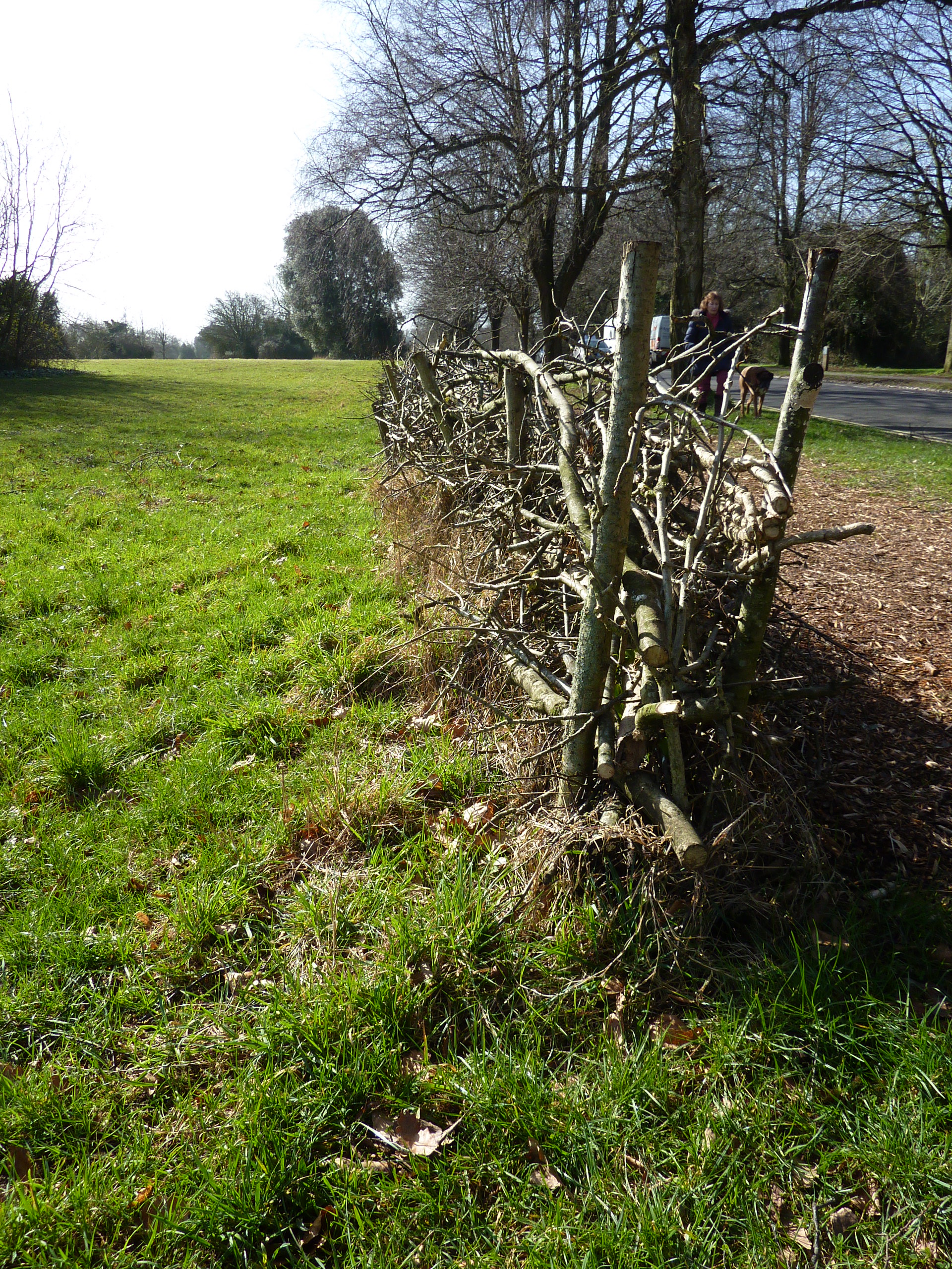
Here is the a “dead hedge” on the downs, rebuilt by volunteer labour last month to help protect the wildflower meadow beside it from joggers; just one example of what self-help can do.

downs-hedging

Who knows, we might even get our urban sparrows back.

Richard Bland  March 2017

Bristol’s remarkable trees mapped

Bristol Tree Forum has just added a new page to our web site. The new Trees of Bristol page provides access to an interactive guide to many of Bristol’s remarkable public tree collections – collections which are accessible to us all in and around the city including Clifton and Durdham Downs, Ashton Court Estate, Kings Weston Estate, Bishops Knoll and many other open and green spaces such as Eastville, St Andrews and Victoria parks.

We aim to help those who love and care for trees to track down and visit any of over 100 locations where trees can be enjoyed. We have already mapped some 15,000 trees (and growing), many of which are within easy walking or cycling distance.

There is also a special Stumps Collection page which builds on Bristol City Council’s trees data and shows all the sites in the city where there is an opportunity for any of us to have a new replacement tree planted. If you are interested in planting a tree at one of these locations, please take a look at our Become a tree champion page and contact us.