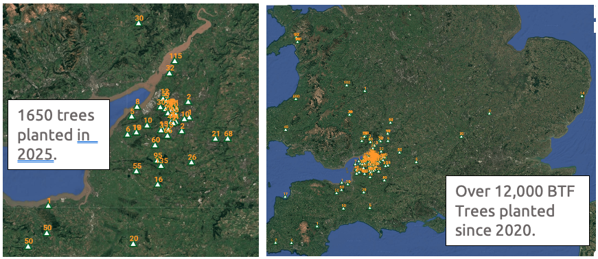
Once again, Bristol Tree Forum are giving away tree saplings. Since 2020, we have given away over 12,000 for tree lovers to plant around Bristol…. and beyond!
Our Tree Giveaway is now closed- All the trees on offer are now taken.
Perhaps one of the most significant things we can do to help protect our future environment, promote nature and make the world a better place for generations to come is to plant a tree. It may be that trees we plant today will continue to provide benefits for the environment, wildlife and people, for hundreds of years to come.
Planting trees is still the most effective and widespread means of removing CO2 from the atmosphere. For instance, a single mature oak tree is the equivalent of 18 tonnes of CO2 or 16 passenger return transatlantic flights. However, it is in our cities that trees provide the greatest benefits; cleaning our air, reducing flooding, reducing traffic noise, improving our physical and mental health, and, crucially, reducing temperatures during heat waves.
During heat waves, that are predicted to increase in both severity and frequency, the “heat island” effect can raise temperatures in cities by as much as an additional 12C over that found in surrounding rural areas. Trees can greatly reduce this effect, partly through shade but also by actively cooling the air by drawing up water from deep underground, which evaporates from the leaves… a process called evapotranspiration. According to the US Department of Agriculture, this cooling effect is the equivalent to 10 room sized air con units for each mature tree.
Thus, trees are a crucial, but often ignored, element in increasing our resilience to climate change.
The UK is one of the most nature depleted countries in the world, and have lost nearly 70% of our biodiversity since the industrial revolution. Trees are vital in supporting biodiversity. With national legislation now allowing around 60% of development sites to be exempt from the need to replace lost biodiversity, and this biodiversity permitted to be replaced anywhere in the country, our city trees are under greater threat than ever before. Furthermore, the proposed new Local Plan, which sets planning policy for the next decade or more, appears to reduce protection for Bristol’s green spaces, allowing these to be built upon.
Therefore, increasingly, it is up to us to protect nature, and what better way of doing this than to plant a tree?
What is the Bristol Tree Forum doing to help?
It is said that the best time to plant a tree is 20 years ago, and the second best time is now.
Unfortunately, important mature trees are constantly being lost to development, damage and disease. Though these might easily be replaced by new trees, what is less easy is replacing the decades or even centuries that the tree has taken to grow, the carbon that the tree has sequestered, the ecosystems the tree supports and all of the other benefits trees provide. For these reasons, much of the work of the Bristol Tree Forum focuses on protecting our existing trees. These efforts are particularly crucial in the urban environment where our trees are under the greatest threat.
However, as well as advocating the retention of life-saving trees in our city, Bristol Tree Forum have been encouraging new tree planting by holding an annual tree giveaway since 2020; the ancient trees of the future are being planted today! Most of Bristol’s trees are sited in private land and gardens, so the trees we have are mostly thanks to the efforts of Bristol residents, and it is those residents we must look to if we want to increase our tree canopy.
Over the last five years, we have given away over 12,000 trees, with species as diverse as English and sessile oak, downy birch, silver birch, grey birch, alder, alder buckthorn, rowan, Scots pine, sweet chestnut, sycamore, spindle, wild cherry, apple, pear and plum.
This year’s Tree Giveaway has been made possible by the generous support of Maelor Forest Nurseries, based on the Welsh borders.
Thanks to Maelor, we are able to offer a variety of species of different mature stature and preferred habitats. This year we are giving away:
English oak (Quercus robur), hawthorn (Crataegus monogyna), beech (Fagus sylvatica), hornbeam (Carpinus betulus), grey alder (Alnus incana), and crab apple (Malus sylvestris).
We will get delivery of the saplings in mid to late February, when the trees can be collected from a site in Redland, Bristol.
The small saplings, or whips, come bare-rooted (i.e. out of the soil) and need to be planted as soon as possible after collection, although the viability of the trees over winter can be extended by storing the trees with the roots covered in damp soil.
To order your tree saplings:
The Tree Giveaway is now closed- All the trees on offer are now taken.
Email: xxx with the subject “Tree Giveaway” and tell us:
Your name and email.
Your post code – for an approximate location of the planned planting sites, so that we can include these on our map.
How many of each species you would like – English oak, hawthorn, beech, hornbeam, grey alder, or crab apple.
We will email you to organise a collection date and time in February.
In its Information Statement of October 2025 concerning its recent fencing works at Stoke Lodge Playing Fields, Cotham School has chosen to misunderstand our concerns about the welfare of the trees at Stoke Lodge Playing Fields.
‘In planning the work to reinstate the fence, the School wanted to respond to feedback, to improve safety by removing muddy paths, to respond to the Bristol Tree Forum concerns regarding footpaths impacting on the roots of trees protected by Tree Preservation Orders, to reduce any other ecological impact and to create an enhanced local open space.’
Our complaints about the detrimental impact caused by the school’s original fencing layout on all the trees – not just the trees protected by Tree Preservation Orders (TPOs) – growing around the boundary of the site and on the playing fields were made in February 2020, nearly six years ago, in this blog: The trees at Stoke Lodge Park and Playing Fields – a letter to the Council. Cotham School has ignored these complaints and has never approached us to discuss our concerns.
Furthermore, Cotham School’s decision to drive its new fencing through the root zones of several TPO trees, one of which is a veteran boundary oak, and to destroy other trees, some of which are protected by a TPO, makes it clear to us that the school continues to ignore the welfare of the trees growing at Stoke Lodge.
We have reported these most recent breaches of TPO legislation to the Local Planning Authority. We have also made clear to Bristol City Council our concerns about the welfare of the Stoke Lodge trees generally. We have been ignored.
As a result of this neglect, the long-term welfare of all the trees growing on and around the playing fields is at risk.
A small grove massacred to the last ash,
An oak with heart-rot, give away the show:
This great society is going to smash;
They cannot fool us with how fast they go,
How much they cost each other and the gods.
A culture is no better than its woods.
W.H. Auden from ‘Bucolics, II: Woods’
Nearly six weeks ago, on 17 April, our hopes of preserving our beloved Brislington Meadows were dashed. Homes England has been allowed to continue with its plans to use the land for housing. The almost universal cry of ‘No!’ from across the city has fallen on deaf ears; Homes England will carry on regardless.
But we haven’t given up. We have all – The Bristol Tree Forum, Greater Brislington Together and Save Brislington Meadows Group – been searching high and low to find a way to stop this, even at the eleventh hour. And we’ve succeeded! We’ve found serious omissions in the planning inspector’s decision which, we believe, give us grounds to have it overturned.
Here’s a summary of the reasons why we think the decision should be set aside. They are a bit technical, but they are important:
The Inspector’s Decision has entirely missed the fact that part of the site – part of the proposed vehicle access at the north-west corner to Broomhill Road, with a strip of housing development there (the only viable point of access onto the development site) – is designated in the adopted Site Allocations and Development Management Policies (SADM) as ‘Important Open Space: Belroyal Avenue, Brislington’.
SADM policy DM17 states: ‘Development on part, or all, of an Important Open Space as designated on the Policies Map will not be permitted unless the development is ancillary to the open space use.’ The failure to have regard to this clear conflict with policy was a breach of s.38(6) and s.70 of the Planning and Compulsory Purchase Act 2004. It’s notable that this part of the site is outside of the Site Allocation, discussed below, which the Inspector placed so much weight on.
What’s more, this same part of the development was confirmed by the Council as a public open space called Belroyal Avenue Open Space in its 2008 Bristol Parks and Green Space Strategy. Because of this and its historic use for recreation, the site is protected by a statutory trust under s.10 of the Open Spaces Act 1906. However, when this land was sold to Homes England in March 2020, the Council failed to meet the requirements of s.123(1) and (2A) of the Local Government 1972. As a result, the site remains subject to the statutory trust, held for the enjoyment of the public, and may not be developed. The principle of the statutory trust was recently confirmed by the Supreme Court in the case of Day v. Shropshire. Even though this case was not brought before the planning inspector (it was published only three days before our three-week planning appeal ended), the legal principle at the heart of it was a material consideration that should have been taken into account in the Inspector’s 17 April decision. This is especially so, given the earlier 1 November 2016 Cabinet decision (item 12) to ignore the 2012 decision of the Greater Brislington Partnership not to declare this land surplus to their Green Space requirements and decide that the land should be sold anyway. Site ‘1’ on map N5954e – which was available when the Cabinet met in November 2016 – clearly shows the Belroyal Avenue Open Space as owned by the Council and subject to its 2008 Bristol Parks and Green Space Strategy designation.
The Brislington Meadows Site Allocation policy, BSA1201 (at page 154), states that ‘the development should retain or incorporate important trees and hedgerows within the development which will be identified by a tree survey.’ The Inspector identified a number of ‘relatively important trees for the purposes of BSA1201’ which would be lost. To allow this must be a breach of the BSA1202 requirement. Despite this, they then found compliance with the policy. This is irrational, as is the fact that they judged that ‘broadly speaking, the most important hedgerows would see the most retention’. This must mean that some of the other most important hedgerows will be lost. This is also in conflict with BSA1201.
Compliance with BSA1201 is also used to reduce significantly the weight accorded to the breach of DM17 in respect of the requirement to integrate important existing trees. This gives another ground of challenge in relation to the Inspector misinterpreting the criterion in BSA1201 and/or irrationally failing to acknowledge that the loss of important trees and hedgerows constitutes a breach of BSA1201, being compounded by a consequential reduction in weight accorded to the conflict with DM17.
For all these reasons, we’ve a strong case to make to overturn the inspector’s decision. Time is running out, though – we only have until this coming Friday, 26 May, to issue proceedings. It is tight, but we could do it. But we’ll need to find at least £50,000 to bring and argue our case.
No doubt Homes England would be determined to fight us all the way and, whilst they seem to have access to almost limitless public funds and can afford the most expensive lawyers, we don’t. We’re just a group of local volunteers doing the best we can to save this precious green space. We don’t have much money – certainly not £50,000! Any money we can raise will depend on the generosity of the public. This is a big ask, especially as times are hard and money is tight. Also, should we lose (and we could), Homes England will want their costs paid as well. This is just too much of a risk.
We’ve written to the Council asking if they plan to challenge the decision and have said why we think they have a case. Sadly, we’ve had no answer. We suspect they’ll be reluctant to do so and expose themselves, yet again, to criticism for their mistakes and misjudgements. This is perhaps especially true given that, as well as losing the appeal, the Inspector has also ordered them (actually, us tax payers) to pay a large part of Homes England’s appeal costs.
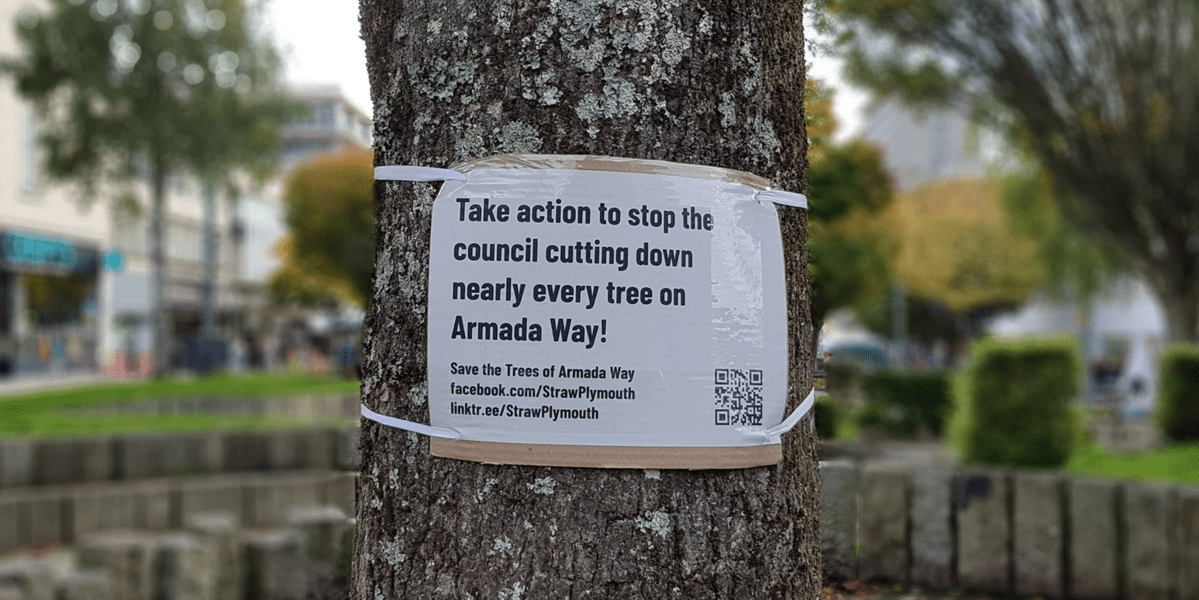
Our Friends at Straw (https://strawplymouth.com/), have been fighting hard to save the few remaining trees on Armada Way, Plymouth so we decided we would try to understand the true impact of the soon-to-be-obligatory Biodiversity Net Gain requirements – how they have been used compared with how they ought to be used – so that the trees that still grow there are properly valued and the loss of their companions can be compensated.
Our conclusion? Over 1,300 extra new trees will need to be planted to replace what has been lost and achieve the 20% net gain promised by the Council.
We have been looking in detail at the Armada Way Biodiversity Net Gain assessment report and calculations, which were provided as part of Plymouth City Council’s ‘Meaningful Community Engagement’. We referred to the Biodiversity Net Gain Metric 3.1 User Guide and additional guidance. This document details our thoughts on the assessment. In summary, we believe the assessment has several flaws that led to the baseline (existing) habitat being undervalued. We also found there was a major flaw in the Metric itself, which led to a significant overestimation of new tree (post-intervention) habitat area. The new Metric (4.0), which supersedes the one used in this assessment, has rectified this issue. If the new Metric were to be used, well over 1000 new trees would need to be planted on site to compensate for losses of healthy, mature trees and achieve the required Biodiversity Net Gain.
Background to Biodiversity Net Gain
Plymouth City Council (PCC) along with many other local authorities, were early adopters of Biodiversity Net Gain (BNG), which is due to become mandatory in November 2023 as part of the Environment Act 2021. While planning permission for nearly all new developments will require a biodiversity increase of 10% or more, Plymouth City Council have decided that they will require at least 20% BNG for this scheme.
The BNG Assessment for the Armada Way development claimed that a 25.09% BNG would be delivered on site. Biodiversity Metric 3.1 was used for the assessment, which was undertaken by the Environment Partnership (TEP) using YGS tree survey data; with baseline habitat ‘walkover survey’ data provided by a local ecologist. The Biodiversity Metric is a tool used by ecologists to measure changes in biodiversity on a development site. Biodiversity Metric
3.1 has now been superseded by Biodiversity Metric 4.0, which was released on 24 March 2023 (more on this later).
In a BNG Assessment, the biodiversity value of a development site, pre and post ‘intervention’, is measured. Post-development biodiversity value can be increased through the enhancement of baseline habitats and/or the creation of new ones either on or offsite.
Biodiversity value is calculated in Habitat Units (HUs). These are derived from the habitat area, the habitat’s ‘distinctiveness’ and its condition, as well as any ‘strategic significance’ applicable to the site of the habitat. The time taken to achieve the target condition of newly created habitats is also taken into account, as well as the difficulty involved in creating the habitat. A 30-year maintenance and monitoring plan must be included to ensure newly created habitats will survive and reach the desired condition within the period.
Requests from STRAW for further information and evidence
STRAW tell us that they had several concerns and queries regarding the Armada Way BNG Assessment so wrote to the assessor asking for clarification on several points. They also wrote to the ecologist who carried out the baseline habitat walkover survey. Despite a follow-up email, they never received a reply from the assessor. The Armada Way development project manager at PCC, assured STRAW and Plymouth Tree Partnership that the BNG Assessment had been ‘triple checked’ and peer-reviewed and promised that the peer review would be shared. Despite repeated requests, this information was never shared.
Concerns about the Armada Way assessment
Significant overestimation of post-intervention habitat area
One of STRAW’s main concerns around the BNG Assessment for Armada Way, was the significantly greater habitat area ascribed to post development (new) trees than to the existing trees, due to an issue with the Metric itself. We accept that the PCC’s ecologist followed Metric 3.1 correctly in using actual Root Protection Area (RPA) calculations for the existing trees and in using the ‘Urban Tree Helper’ tool for new trees to be planted. However, the two methods are not comparable. If the existing tree measurements had been put into the Urban Tree Helper tool, instead of a habitat area of 0.67 hectares (ha), they would have had a habitat area of over 3 ha. This significant flaw in Metric 3.1 has now been addressed in Metric 4.0, which now requires existing tree habitat measurements to be entered into the tool as well as post-intervention (new tree) measurements.
Note: Root protection area (RPA) is used as a proxy for tree habitat area. RPA is calculated using a standard equation provided in BS5837:2012 – Trees in relation to design, demolition and construction. Recommendations, using the ‘diameter at breast height’ (DBH) measurement, where the diameter of the trunk is measured 1.5m above ground.
Although we believe PCC’s ecologist followed the 3.1 User Guide correctly for habitat area calculations, (i.e. using actual root habitat area for the baseline trees and the Urban Tree Helper tool for new trees) we believe they should have noted the significant flaws in the use of different methods for the baseline and post-intervention calculations, which result in the lowest possible habitat area for baseline trees and a significantly exaggerated habitat area for newly planted ones.
Issues with use of the Urban Tree Helper tool only for the new trees
The BNG Urban Tree Helper tool assigns trees to ‘Small’, ‘Medium’ and ‘Large’ categories, according to their DBH. When considering the categories for new trees to be planted, the ‘Small’ category is for trees with a DBH of between 7cm and 30cm after 30 years and the ‘Medium’ category for trees with a DBH of >30 – <=90cm after 30 years. Large category trees are those with a DBH of 90 cm or over.
The 33 new trees (to be planted) were assessed as reaching the ‘Medium’ category after 30 years. Having consulted tree experts and looked at the available literature, we do not believe that these 33 trees should have been assigned to the Medium category. They should have been assigned to the Small category. What is really interesting is that the Medium category trees – those with a DBH of between >30 and <=90cm – are all given a ‘metric area equivalent’ of a tree with a 90cm DBH, so that even a 31 cm DBH tree has the equivalent habitat area of a 90cm DBH tree. This obviously means a significant overestimation in the habitat area for a tree of 31cm DBH. Our researches have found that, if these trees did reach the medium category after 30 years, which is very unlikely, they would only just enter this category – i.e. they would be at the very low end of the range.
Importantly, an existing tree with a 30cm DBH, using Metric 3.1, would be given a habitat area based on 30cm – 0.0041 ha whereas a newly planted tree – still expected to reach a DBH of 30cm after 30 years, would be assigned a habitat area of 0.0366 ha. This is clearly ridiculous given that they are both the same size trees.
Using Metric 3.1, if there were 100 existing trees due to be felled, that all had DBHs of 30cm, the total habitat area would be 0.41 ha. If these were to be replaced by 100 trees that were expected to achieve a DBH of 30cm after 30 years, they would be credited with a habitat area of 3.66 ha even though they would probably never grow so large. This demonstrates this important failing of Metric 3.1 and the huge overestimation of the habitat value of newly created tree habitat area as part of the proposed scheme. Fortunately, this has been addressed in Metric 4.0, with the requirement for existing trees also be assessed using the Urban Tree Helper tool – though this is now too late for the Armada Way trees. Metric 4.0 also addresses the issue of newly planted trees being wrongly assigned to the Medium category and thereby achieving a significantly exaggerated habitat area. All new trees must now be assigned to the Small category unless there is strong evidence to support assigning them to higher categories.
We entered baseline tree data into the Urban Tree Helper tool. The Results show a much higher baseline habitat area (over 3 ha) when following the Metric 4.0 User Guide. Post- intervention habitat area is 1.6 ha; a net loss.
Other concerns with the BNG assessment
Not including all existing trees in the baseline calculations
Apart from this obvious flaw that significantly overestimates new habitat area, we believe the assessment also has several other flaws. There were 11 ‘Category U’ trees that should have been included in the baseline habitat area calculations but were left out. These are trees that were considered unsuitable for retention under BS5837:2012. They should however, according to the Metric 3.1 User Guide, have been included in the baseline calculations. This would have given a greater total habitat area for the baseline urban trees on the site.
Trees growing in groups were also disregarded and counted as just one tree. Had they all been assessed then this would also have increased the baseline habitat area (as detailed in Section 7 of User Guide 3.1).
Misleading statements on damage to the built environment
The BNG assessment stated that ‘the current tree stock is understood to be generally inappropriate to their urban setting, with several causing damage to the built environment’. No evidence was referenced to underpin this statement in relation to Armada Way, and it is not relevant to a BNG Assessment save for assessing their condition. The assessor appears to have used data from a larger tree survey of the area (487 trees), not just Armada Way, and there seems to be no clear evidence in the reports that damage had occurred in Armada Way from the existing (now mostly destroyed) tree stock.
Strategic significance
The BNG Metric includes a consideration of ‘strategic significance’ where local plans and strategies are taken into account. We believe there is room for doubt over the strategic significance being set as ‘low’. The Plymouth and South Devon Joint Local Plan, the Plymouth Plan for Trees and the Plymouth Policy Area Open Space Assessment were possibly relevant and if included might have justified setting the baseline ‘strategic significance’ at ‘medium’ or ‘high’. The Plymouth and South Devon Joint Local Plan refers to the mitigation hierarchy: ‘AVOID LOSS – retain suitable existing arboricultural features on site wherever possible’. DEV26.5 in the plan states that ‘applying Biodiversity Net Gain is not an alternative to the application of the mitigation hierarchy and it would be unacceptable practice for a developer to compensate without first seeking to avoid and mitigate’. Whether or not this should have been considered under ‘strategic significance’, it should have been an important consideration for the project. There appears to be no evidence of any attempt, at any stage of the design process, to retain existing healthy, mature trees.
The Plymouth Plan for Trees (2018) also does not appear to have been considered. The following principles should arguably have been taken into consideration:
Plymouth’s trees and woods should be celebrated. Arguably an urban forest in the heart of the city, which happens to be a designated public green space and in a ward with well below average tree cover, should have been valued and celebrated and included in the design from the early stages. Tree canopy cover in the St Peter and the Waterfront ward is 9.3% (forestresearch.gov.uk). The national average for council wards is 16%. The minimum council wards should aim for is 20% (Woodland Trust, 2023). New trees, even if greater in number, would have a much-reduced canopy cover, even in the longer term.
UseallavailableplanningandforestrylegislationandpowerstosafeguardPlymouth’strees.It would be expected that the Plymouth and South Devon Joint Local Plan (adopted in 2019) would have informed the process, particularly: ‘AVOID LOSS – retain suitable existing arboricultural features on-site where-ever possible’.
Increase overall canopy cover in the city.The Armada Way proposal appears to reduce canopy cover, despite tree numbers increasing. Tree canopy cover in the St Peter and the Waterfront ward (that Armada Way lies within) is 9.3% (forestresearch.gov.uk). The national average for council wards is 16%. The minimum council wards should aim for is 20% (Woodland Trust 2023).
The Plymouth Policy Area Open Space Assessment identified Armada Way as a Green Corridor. This does not seem to have been considered and could potentially have increased the ‘strategic significance’ score in the BNG assessment. If these plans and strategies were considered and ruled out as having ‘strategic significance’, the reasoning should have been explained in the assessment, or at least provided upon request, to meet BNG transparency principles.
Habitat condition
There may also have been an undervaluation of the condition of tree habitat and ‘other habitats’ in the assessment. The lichen, bryophyte and other epiphyte communities associated with the existing trees (now gone) does not seem to have been adequately considered. There is the potential for bat roosts, and we have photographs of bryophytes, lichen communities and fungi associated with the trees. There were also a number of nests in the trees that were felled (not active ones, but evidence of the suitability of the trees for nesting). These factors form part of the condition assessment of Urban trees.
The condition of grass habitats and hedge features were set to low, even though they had recently been significantly cut back, and according to the User Guide, they should have been given higher scores as a precautionary measure if recently altered/ cut back. We noted at least 10 different plant species making up the grass habitats, possibly over 15 species. If these had been considered, as they should have been, the condition score would have been higher. When we queried this with the ecologist who undertook the habitat walkover survey, they said they visited the site for an hour to look at the grassland which had just been mown and that he was not involved in the BNG assessment. We also understand that the survey was also carried out during the intense heatwave of 2022.
Lack of maintenance budget
It should be noted that the stated BNG (25.09%), which we believe we have shown here to be incorrect, was to be achieved after 30 years. No maintenance budget had been identified beyond the project construction period (approx. 2 years). Further maintenance funding was to be sought from future (unknown) levies on residential development projects, i.e. funding for 28 years of maintenance had not been secured. With the significant uncertainties over changing climatic conditions over this period, and temperature increases highly likely, we would expect a low confidence in survival potential of newly planted trees. This does not comply with the new provisions of the Environment Act 2021 which require that post intervention habitats be maintained for at least 30 years.
From our detailed analysis, we have advised STRAW that if PCC used the same baseline data for urban tree habitat with the baseline urban tree habitat updated to 3.1137 hectares, which is the area calculated using Metric 4.0, PCC would need to plant at least 1,384 ‘Small’ category trees to achieve at least the 20% net gain promised. On this basis, we calculate that the plans as detailed in the TEP BNG assessment will instead deliver a 62.10% net loss of habitat.
We conclude that, ignoring the other issues identified above, even if PCC’s calculations were compliant with the Metric 3.1 User Guide, the information detailed here highlights the actual losses on the ground. These losses should be of concern to PCC and should be communicated to the public. It is too late to amend the plan to include the 110 healthy mature trees that have now been felled. The remaining trees could however be included. Significantly more trees would need to be planted to compensate for these losses than the number currently proposed, and even more to achieve the 20% biodiversity net gain aspired to. We believe that both the assessment and the methodology were flawed and that this is an important case study that should inform other projects.
In our view, it would be prudent now for PCC to undertake a new BNG assessment (particularly as plans have since been amended and most of the trees surveyed have now been felled) using Metric 4.0 and to publicly share the findings, especially given the previous lack of transparency on the ecological assessments.
We sincerely hope that they will do this and meet their obligation to make good the losses which Plymouth has suffered.
Bristol City Council is currently writing a tree strategy for Bristol. This is welcome news, as we have been calling for such a strategy to be developed for more than a decade.
A tree strategy should be an evolving process rather than a document which may quickly become out of date. This is particularly true in our rapidly changing world – environmentally, climatically and politically. To provide an effective response to the challenges these present, a group of representatives from both civic and professional groups (along the lines of the Bristol Advisory Committee on Climate Change (BACCC), should be established to help coordinate further research and make recommendations to Bristol City Council and other stakeholders as the situation changes.
We also recommend that the development of a tree strategy should take full advantage of exemplars from other local authorities[1]. We should have the ambition to make Bristol’s tree strategy the best.
Here follow 18 key points that we would expect to see included in a strategy.
Buy in from all the stakeholders involved. Many council departments (as well as Parks, there is Highways, Education and Planning) have a role to play in the management of Bristol’s trees. We need to see evidence that all such departments are fully involved in the development of the strategy. In particular, with the current review of the Local Plan, it is essential that Planning is fully engaged with the strategy, and that the two documents are consistent and properly cross-referenced. The tree strategy needs to be incorporated into the new Local Plan. In addition, other important landowners (such as the universities, utilities providers, housing associations, schools and hospitals) have a role to play in contributing their expertise to the strategy and implementing its goals. As well as the Bristol Tree Forum, many community groups have an interest in tree planting in Bristol and should be involved and consulted.
When council trees are removed, they must be replaced. At present there are more than 800 street tree stumps and empty tree pits around the city – sites where trees once grew. A plan to plant all these missing trees within five years needs to be included. In the future, when any council trees are damaged or felled, they should be replaced within the next planting season.
There needs to be community engagement in tree management decisions both at the level of individual trees and in strategic decisions. In recent years we have seen a rise in community led campaigns to protect trees, such as the Ashley Down Oak, the M32 maples and Baltic Wharf, and this is indicative of a disconnect between the Council and the communities it serves. When the balance of the Environment Act 2021 takes effect later this year, Councils will be obliged to consult when street trees are being considered for removal[2]. This is too narrow and should be extended to include where any public tree is being considered for removal. Therefore, part of the strategy should be promoting community engagement, providing mechanisms for engagement and then taking account of the concerns of the community and tree campaigners alike.
There should be one person responsible for trees within Bristol City Council. At present we have tree planning officers, tree maintenance officers and tree planting officers with no single individual or office accountable overall, often resulting in a lack of appropriate action or people working at cross-purpose. It is also concerning that Highways are able to remove street trees without any consultation.
There needs to be a plan to address the massive inequality in tree cover in Bristol, which often mirrors social and financial deprivation in the City. For instance, additional protections could be given to trees, and tree planting prioritised, especially in deprived areas such as the City Centre, Harbourside and St Pauls.
When developers remove trees, the replacements required should be planted by BCC. Too often developers have shown themselves incompetent or unconcerned when planting trees, so the trees fail or are never planted. In the case of Metrobus, there has been a more than 100% failure rate of trees in some places (trees have been replaced multiple times). We have an excellent tree planting team in Bristol and we should benefit from requiring them to organise and implement the planting required. The cost should be funded by the developer.
Retaining existing trees must be a major part of the strategy. A tree strategy cannot be just about planting new trees, the benefits of which will not be realised for decades, but crucially about retaining and protecting existing trees and the benefits they are already providing. As such, the strategy must address the threats to existing trees. Planning is crucial in this so we would expect major engagement with Development officers to address the current and future problems.
Planning Enforcement must address the illegal removal of or damage to trees. At the moment there are no consequences following the unauthorised damage or destruction of trees. This must change. Other neighbouring local authorities manage to do this but not Bristol. A strategy must include a review of the reasons for the existing lack of effective enforcement and make recommendations as to how this can be rectified.
Developments should be built around existing trees as is already required[3]. Other local authorities do this but not Bristol. This will require a change of culture in the planning department so that pre-application discussions with developers make it clear that this will be required.
The sites for the replacement trees must be agreed before Planning Applications are approved. This is required by planning policy (BCS9 and DM17), but currently developers are being allowed to, instead, pay a “fee” into Section 106, and frequently the replacement trees are never planted. Trees form an important part of our urban habitat. The calculation of tree replacements required to compensate for their loss must be aligned with the Biodiversity Metric as adopted under the Environment Act 2021.
Spend the £ 900K+ reserved for tree planting. Connected with the above point, a strategy needs to include a mechanism for spending the existing £900K+ of unspent tree planting Section 106 money within the next three years.
A strategy to increase Bristol’s tree canopy cover (or at the minimum, maintain existing canopy cover) needs to have a route to implementation This must include addressing the loss of street tree canopy cover by being bolder in selecting new tree planting sites and planting large-form trees wherever possible. Trees such as rowans and flowering cherries are short-lived and will never provide much canopy or become robust enough to survive our challenging urban environment in the long-term.
Canopy Cover needs to be measured with an agreed methodology with confidence limits (levels of doubt in the estimate) made clear. In the first instance, we need to establish the baseline year and percentage tree cover from which progress will be measured. Only then will it be possible to show whether a trend has been determined. Two measurements using different methodologies should not be used to claim an increase in canopy cover. The metric should take account of trees lost so that the figure reflects the true increase, or loss.
Include trees within road changes. There needs to be proper engagement with Highways at early stages of the design process for road changes to look at retaining the maximum number of existing trees and including innovative planting opportunities for new large-form trees, such as pavement build-outs.
For new developments, trees should be properly considered at the pre-application stage, with appropriate consultation with stakeholder groups. Too often, the mitigation hierarchy requiring the removal of trees to be a last resort is disregarded, so that it is only after the design has been finalised that the existing trees are considered and removed where they conflict with the design scheme.
Biodiversity Net Gain (BNG) calculations need to be checked by the Local Planning Authority and biodiversity loss must not be monetised as BTRS has been. BNG, if properly implemented, makes sure that biodiversity on development sites is properly measured and will provide a net gain (soon to be least 10%) is factored in. However, at present, developers’ calculations are not being checked. When we have provided properly evidenced calculations, these have been dismissed by the LPA as mere differences of opinion. You cannot have differences of opinion on facts. The LPA must require that BNG calculations are presented in a way that can be checked by anyone interested and actually do the checking. In addition, ensuring BNG must require that the development site does not lose its biodiversity. If this is not possible, then its immediate local environment must be used to offset any onsite losses. Onsite losses must not be compensated for in some faraway place completely removed from Bristol.
Planning Applications involving trees must mention this fact in the title. Too often, applications that involve the loss of important trees (or plans to avoid the planting of new trees[4]) do not even mention this fact in the title. This means that it is extremely difficult for community organisations to engage.
Once a planning application has been issued, no removal of trees. A moratorium should be placed on any tree felling pending the outcome of the planning application. This includes applications to demolish buildings which should exclude tree or other habitat removal.
[3] Bristol Core Strategy, policy BCS9 states that, “Individual green assets should be retained wherever possible and integrated into new Developments.”
The latest version of the Biodiversity Metric (BNG 4.0), just published by Natural England, is likely to become mandatory when the balance of the Environment Act 2021 comes into force later this year. We have revisited our June 2022 proposals and reviewed our calculations. Here is the revised version.
The Bristol Tree Replacement Standard (BTRS), adopted a decade ago, provides a mechanism for calculating the number of replacements for any trees that are removed for developments. It was ground-breaking in its time as it, typically, required more than 1:1 replacement of trees lost to development.
The presumption when considering any development involving established trees should always be that trees will be retained. The application of BTRS should only ever be a last resort. It should not be the default choice which it seems to have become.
The starting point for any decision on whether to remove trees (or any other green asset for that matter) is the Mitigation Hierarchy. Paragraph 180 a) of the National Planning Policy Framework sets it out as follows:
If significant harm to biodiversity resulting from a development cannot be avoided (through locating on an alternative site with less harmful impacts), adequately mitigated, or, as a last resort, compensated for, then planning permission should be refused.[1]
BTRS is and should always be ‘a last resort’. This is reflected in the Bristol Core Strategy, policy BCS9 adopts this approach and states that:
Individual green assets should be retained wherever possible and integrated into new developments.[2]
However, with the development of a new Local Plan for Bristol, we believe that the time has come for BTRS to be revised to reflect our changing understanding of the vital importance of urban trees to Bristol in the years since the final part (SADMP) of the Local Plan was adopted in 2014.
In addition, Bristol has adopted Climate and Ecological Emergency Declarations so a new BTRS will be an important part of implementing these declarations. Nationally, the Environment Act 2021 (EA 2021) will come force later this year. This will require nearly all developments to achieve a Biodiversity Net Gain (BNG) of at least 10%. Our proposal provides a mechanism for complying with this new requirement and so aligns BTRS with the BNG provisions of the EA 2021.
Background
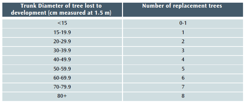
Under current policy – BCS9 and DM17[3] – trees lost to development must be replaced using this table:
Table 1 The Current DM17/BTRS replacement tree table.
However, when the balance of EA 2021 takes effect, the current version of BTRS will not, in most cases, be sufficient to achieve the 10% BNG minimum that will be required for nearly all developments. A new section 90A will be added to the Town and Country Planning Act 1990 and set out the level of BNG required (see Schedule 14 of EA 2021).
The Local Government Association says of BNG that it:
…delivers measurable improvements for biodiversity by creating or enhancing habitats in association with development. Biodiversity net gain can be achieved on-site, off-site or through a combination of on-site and off-site measures.[4]
GOV.UK says of the Biodiversity Metric that:
where a development has an impact on biodiversity, it will ensure that the development is delivered in a way which helps to restore any biodiversity loss and seeks to deliver thriving natural spaces for local communities.[5]
This aligns perfectly with Bristol’s recent declarations of climate and ecological emergencies and with the aspirations of the Ecological Emergency Action Plan,[6] which recognises that a BNG of at least 10% net gain will become mandatory for housing and development and acknowledges that:
These strategies [the Local Nature Recovery Strategies] will guide smooth and effective delivery of Biodiversity Net…
Our proposed new BTRS model
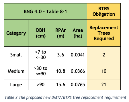
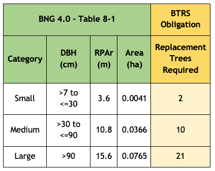
We propose that the Bristol Tree Replacement Standard be amended to reflect the requirements of the EA 2021 and BNG 4.0 and that the BTRS table (Table 1 above) be replaced with Table 2 below:
The Replacement Trees Required number is based on the habitat area of each of the three BNG 4.0 tree category sizes (Table 8-1 below) divided by the area habitat of one BNG 4.0 Small category tree (see section 3 below) plus a 10% net gain. This is rounded up to the nearest whole number – you can’t plant a fraction of a tree.
The reasoning for our proposal is set out below.
Applying the Biodiversity Metric to Urban trees
The most recent Biodiversity Metric (BNG 4.0) published by Natural England this April, defines trees in urban spaces as Individual trees called Urban tree habitats. The User Guide states that:
Individual trees may be classed as ‘urban’ or ‘rural’. Typically, urban trees will be bound by (or near) hardstanding and rural trees are likely to be found in open countryside. The assessor should consider the degree of ‘urbanisation’ of habitats around the tree and assign the best fit for the location.
Individual trees may also be found in groups or stands (with overlapping canopies) within and around the perimeter of urban land. This includes those along urban streets, highways, railways and canals, and also former field boundary trees incorporated into developments. For example, if groups of trees within the urban environment do not match the descriptions for woodland, they may be assessed as a block of individual urban trees.
Calculating Individual trees habitat
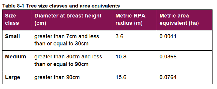
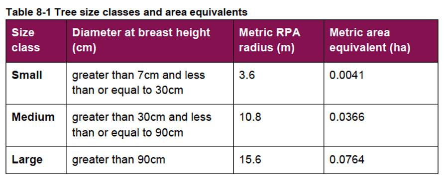
Table 8-1 in the BNG 4.0 user guide is used to calculate the ‘area equivalent’ of individual trees:
Note that the tree’s stem diameter will still need to be ascertained using BS:5837 2012,[7] and that any tree with a stem diameter (DBH) 7 mm or more and of whatever quality (even a dead tree, which offers its own habitat benefits) is included. Under the current DM17/BTRS requirement, trees with a DBH smaller than 150 mm are excluded, as are BS:5837 2012 category “U” trees. This will no longer be the case.
The Rule 3 of the BNG User guide makes it clear that like-for-like replacement is most often required, so that lost Individual trees (which have Medium distinctiveness) are to be replaced by Individual trees rather than by other habitat types of the same distinctiveness.[8]
Forecasting the post-development habitat area of new Individual trees
The BNG 4.0 User Guide provides this guidance:
8.3.13. Size classes for newly planted trees should be classified by a projected size relevant to the project timeframe.
• most newly planted street trees should be categorised as ‘small’
• evidence is required to justify the input of larger size classes
8.3.14. When estimating the size of planted trees consideration should be given to growth rate, which is determined by a wide range of factors, including tree vigour, geography, soil conditions, sunlight, precipitation levels and temperature.
8.3.15. Do not record natural size increases of pre-existing baseline trees within post-development calculations.
Our calculations are based on ‘small’ category replacement trees being planted.
The likely impact of this policy change
We have analysed tree data for 1,038 surveyed trees taken from a sample of BS:5837 2012 tree surveys submitted in support of previous planning applications. Most of the trees in this sample, 61%, fall within the BNG 4.0 Small range, 38% are within the Medium range, with the balance, 1%, being categorised as Large.
Table 4 below sets out the likely impact of the proposed changes to BTRS. It assumes that all these trees were removed (though that was not the case for all the planning applications we sampled):
The justification for requiring obligations in respect of new or compensatory tree planting is set out in the Environment Act 2021, Policies BCS9 and BCS11 of the Council’s Core Strategy and in DM 17 of the Council’s Site Allocations and Development Management Policies.[9]
Trigger for Obligation
Obligations in respect of trees will be required where there is an obligation under the Environment Act 2021 to compensate for the loss of biodiversity when Urban tree habitat is lost as a result of development.
Any offsite Urban tree habitat creation will take place in sites which are either on open ground or in areas of hard standing such as pavements and are located as close as possible to the site of the lost tree.
Where planting will take place directly into open ground, the contribution will be lower than where the planting is in an area of hard standing. This is because of the need to plant trees located in areas of hard standing in an engineered tree pit.
All tree planting on public land will be undertaken by the council to ensure a consistent approach and level of quality, and to reduce the likelihood of new tree stock failing to survive.
Level of Contribution
The contribution covers the cost of providing the tree pit (where appropriate), purchasing, planting, protecting, establishing and initially maintaining the new tree. The level of contribution per tree is as follows:
Tree in open ground (no tree pit required) £765.21
Tree in hard standing (tree pit required) £3,318.88[10]
The ‘open ground’ figure will apply where a development results in the loss of Council-owned trees planted in open ground. In these cases, the Council will undertake replacement tree planting in the nearest appropriate area of public open space.
In all other cases, the level of offsite compensation required will be based on the nature (in open ground or in hard standing) of the specific site which will has been identified by the developer and is approved by the Council during the planning approval process. In the absence of any such agreement, the level of contribution will be for a tree in hard standing.
The calculation of the habitat required to compensate for loss of Urban trees is set out in Table 8-1 of the Biodiversity Metric (BNG), published by Natural England. This may be updated as newer versions of BNG become mandatory under the Environment Act 2021.
The following table will be used when calculating the level of contribution required by this obligation:
[8] Table 3-2 Trading rules (Rule 3) to compensate for losses. Any habitat from a higher distinctiveness band (from any broad habitat type) may also be used.
[9] These references may need to be changed to reflect any replacement policies adopted with the new Local Plan.
[10] These values should be updated to the current rates applicable at the time of adoption. The current indexed rates as of May 2023 are £1,143.15 & £4,958.07 respectively.
On 24 March 2023 Natural England published Biodiversity Metric 4.0. This revised metric will revolutionise the way we value urban tree habitats, making it clearer than ever that they are a very important habitat.
It is anticipated that BNG 4.0 [1] will be given statutory force when the biodiversity elements of the 2021 Environment Act [2] take effect later this year (see Measuring biodiversity net gain – Publication of Biodiversity Metric 4.0). All new planning applications issued after 24 March, where a Biodiversity Net Gain (BNG) calculation is required, will be required to use it.
Unlike several neighbouring local authorities (e.g., BANES & South Gloucestershire County Council), which have already adopted Supplementary Planning Documents to protect their biodiversity, Bristol City Council has decided not to require this as part of current planning applications until the rest of the EA 2021 comes into force. The failure to do this will have a negative ecological and social impact for the many current planning applications. In the meantime, only developers will benefit.
Given Bristol’s declaration of an ecological emergency in 2020, BNG 4.0 must now be implemented in Bristol. This is a key environment measure which could be adopted at no cost to the council.
The NPPF basis for achieving biodiversity net gain
Paragraph 180 a) of the National Policy Planning Framework [3] (NPPF) echoes the overarching Mitigation Hierarchy principles and obliges local planning authorities to refuse planning permission:
if significant harm to biodiversity resulting from a development cannot be avoided (through locating on an alternative site with less harmful impacts), adequately mitigated, or, as a last resort, compensated for…
Paragraph 179 c), states that plans should:
…pursue opportunities for securing measurable net gains for biodiversity.
BNG 4.0 has been designed to give effect to these two core planning goals.
Pending planning applications
Natural England advises that:
‘Users of previous versions of the Biodiversity Metric should continue to use that metric (unless requested to do otherwise by their client or consenting body) for the duration of the project it is being used for. This is because users may find that certain biodiversity unit values generated in biodiversity metric 4.0 will differ from those generated by earlier versions.‘
Given that the approach to valuing urban trees has fundamentally changed, we urge all ‘consenting bodies’ (LPAs for most of us) to require developers to adopt this new methodology, for Individual trees habitats at least.
We have always argued that the old Urban tree habitat area calculation methodology used in BNG 3.0 is flawed and unworkable, and we advocated for the use of the calculation method given in BNG 3.1, if only for Urban tree habitat area calculations. With the advent of BNG 4.0, we plan now to argue instead for the BNG 4.0 Individual trees habitat methodology to be used.
The BNG 4.0 Guide
Here is a link to the BNG 4.0 User Guide, which was published with BNG 4.0 (the quotes in italics below are taken from it). We set out below the salient points that cover most trees growing in an urban setting.
What is Individual trees habitat?
BNG 4.0 has made a substantial change to the way trees growing in the urban space will be valued and introduces a new broad habitat category called Individual trees (to replace the Urban tree habitat category first published with BNG 3.0):
8.3.1. The broad habitat type ‘Individual trees’ may be used where a tree (or a group of trees) over 7.5 cm in diameter at breast height (DBH) does not meet or contribute towards the definition of another broad habitat type.
8.3.2. Individual trees should not be recorded separately where they occur within habitat types characterised by the presence of trees, such as orchards, lines of trees or wood-pasture and parkland, but can be recorded where they do not form part of a primary habitat description.
8.3.3. Ancient and veteran trees are irreplaceable habitats and the broad habitat ‘Individual trees’ must not be used to record these.
Even though all irreplaceable habitats fall outside BNG 4.0, they should still be recorded in the metric calculation. A special form for this has been built into the calculator and special rules apply.
Note: Paragraph 8.3.1 refers to trees ‘over 7.5 cm in diameter’ but table 8-1 below refers to trees that are ‘greater than 7 cm’. BS5837:2012 requires all trees 75 mm or over to be surveyed – at paragraph 4.2.4.
Broad habitat type Individual trees can be in either ‘urban’ or ‘rural’ habitats:
8.3.4. Individual trees may be classed as ‘urban’ or ‘rural’. Typically, urban trees will be bound by (or near) hardstanding and rural trees are likely to be found in open countryside. The assessor should consider the degree of ‘urbanisation’ of habitats around the tree and assign the best fit for the location.
8.3.5. Individual trees may also be found in groups or stands (with overlapping canopies) within and around the perimeter of urban land. This includes those along urban streets, highways, railways and canals, and also former field boundary trees incorporated into developments. For example, if groups of trees within the urban environment do not match the descriptions for woodland, they may be assessed as a block of individual urban trees.
Either way, they have the same Medium habitat distinctiveness, so the difference is perhaps academic.
Developers may seek to argue that some urban trees in groups or blocks are a woodland habitat or a ‘Hedgerow – line of trees’ habitat and not Individual trees habitat. BNG 4.0 and earlier versions use a different approach to calculating their habitat sizes. This approach is based on canopy area for woodland habitats and a linear measurement for ‘Hedgerow – line of trees’ habitats. However, it is the degree of ‘urbanisation’ that is key.
Trees in private gardens
Individual trees habitats within private gardens are also to be recorded in the baseline calculation, but should not form part of the post-development BNG calculation:
8.3.6. Established trees within gardens should be recorded in a site baseline.
8.3.7. Where private gardens are created, any tree planting within the created garden should not be included within post-development sheets of the metric. The habitat type ‘Urban – Vegetated garden’ should be used.
This is an important distinction and means we should be alive to any attempt to include newly created habitat in private gardens into post-development BNG calculations. The logic is that, as private space is outside the control of the developer, any post-development habitat management obligations they have cannot be applied to these spaces, and so should be excluded from the post-development calculation.
Measuring Individual trees habitat size
Habitat size is one of the key parameters used for calculating a habitat’s value – called Habitat Units (HUs). For baseline area habitats, the formula is based on four parameters:
HU = Area in hectares x Distinctiveness x Condition x Strategic significance.
Note: For linear habitats, length in kilometres is used instead of area.
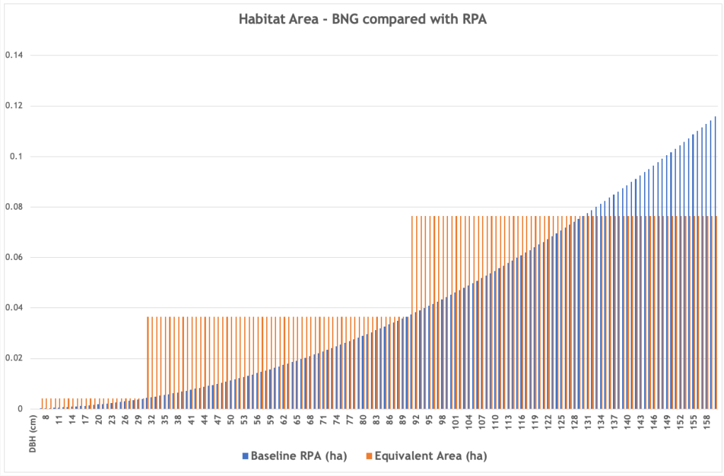
The way BNG 4.0 measures the habitat area of Individual trees has reverted to the methodology used in BNG 3.0 but, thankfully, now uses a table that works!
The effect is far more generous than the one used in BNG 3.1 as it values all the trees in the bottom two categories, Small & Medium, at the top of their range. All Large category trees are given the same habitat value as a tree with a stem diameter (called DBH – diameter at breast height) of 130 cm. [4] Given that the vast majority of urban trees fall within this range – with DBHs of between 7cm and 130 cm – this has the effect of greatly enhancing their habitat value.
The following graph illustrates the effect on a range of DBHs from 7 cm to 160 cm; RPA refers to root protection area and the orange stepped lines are the BNG 4.0 habitat area values assigned to each DBH. [5]
This difference is significant. For example, in a recent application we were involved with, trees on the site that had a baseline Urban tree habitat area of 0.7056 ha using BNG 3.1 now have an Individual trees habitat area of 3.1137 ha when the BNG 4.0 methodology is applied. This makes their habitat unit value much greater than it was before.
Here is the BNG 4.0 Individual trees habitat area measurement methodology:
8.3.8. Once the size, number and condition of trees is known, assessors should generate an area equivalent value using the ‘Tree helper’ within the metric tool ‘Main menu’ (Figure 8-2). The ‘area equivalent’ is used to represent the area of Individual trees. This value is a representation of canopy biomass, and is based on the root protection area formula, derived from BS 5837:2012.
8.3.9. Table 8-1 sets out class sizes of trees and their area equivalent. For multi-stemmed trees the DBH of the largest stem in the cluster should be used to determine size class.
Note: The correct metric equivalent area of Large category trees is 0.0765, not 0.0764.
This same approach applies to Individual trees habitats in groups or blocks:
8.3.12. Assessors should account for the size class (Table 8-1) of each Individual trees within a group or block. The number of Individual trees present within a group or block should be entered into the tree helper to calculate area equivalent. Do not reduce any area generated by the tree helper even if tree canopies overlap.
Assessing baseline Individual trees habitat condition
As ‘condition’ is one of the parameters used for calculating the habitat’s value, each Individual trees habitat tree, group or block needs to be assessed against the following criteria. [6]
Condition Assessment Criteria
A
The tree is a native species (or at least 70% within the block are native species).
B
The tree canopy is predominantly continuous, with gaps in canopy cover making up <10% of total area and no individual gap being >5 m wide (Individual trees automatically pass this criterion).
C
The tree is mature (or more than 50% within the block are mature).
D
There is little or no evidence of an adverse impact on tree health by human activities (such as vandalism, herbicide or detrimental agricultural activity). And there is no current regular pruning regime, so the trees retain >75% of expected canopy for their age range and height.
E
Natural ecological niches for vertebrates and invertebrates are present, such as presence of deadwood, cavities, ivy or loose bark.
F
More than 20% of the tree canopy area is oversailing vegetation beneath.
Number of criteria passed
Condition Assessment Result (out of 6 criteria)
Condition Assessment Score
Passes 5 or 6 criteria
Good (3)
Passes 3 or 4 criteria
Moderate (2)
Passes 2 or fewer criteria
Poor (1)
Note that ‘Fairly Good and Fairly Poor’ condition categories are not available for this broad habitat type.
In our experience, very few Individual Urban tree habitats will ever be assessed as in ‘Good’ condition and many will only ever achieve a ‘Poor’ score. Many urban trees are not native, [7] few survive to become mature, most are subject to some form of management or show ‘evidence of an adverse impact on tree health by human activities’, and most trees in a public space will never be allowed to develop ‘natural ecological niches’ as these often also present a public safety risk.
The same challenges will also apply when attempting to assess the future condition of post-development Individual Urban tree habitats after 30 years have passed (we discuss this below). In our view, every such tree should always be assessed as having a ‘Poor’ outcome given the uncertainties they face.
Assessing baseline Individual trees habitat strategic significance
Strategic significance is the fourth parameter used in calculating HUs. There are three categories – High, Medium and Low:
To qualify as ‘High’, the following evidence needs to be available:
5.4.3. Assessors must provide evidence by referencing relevant documents. If published, the relevant strategy is the Local Nature Recovery Strategy (LNRS). If an LNRS has not been published, the relevant consenting body or planning authority may specify alternative plans, policies or strategies to use.
5.4.4. Alternative plans, policies or strategies must specify suitable locations for habitat retention, habitat creation and or enhancements, and might, for example, be:
Local Plans and Neighbourhood Plans
Local Planning Authority Local Ecological Networks
Tree Strategies
Area of Outstanding Natural Beauty Management Plans
Biodiversity Action Plans
Species and protected sites conservation strategies
Woodland strategies
Green Infrastructure Strategies
River Basin Management Plans
Catchment Plans and Catchment Planning Systems
Shoreline management plans
Estuary Strategies
5.4.5. If no alternative is specified, agreement should be sought from the consenting body or Local Planning Authority when determining strategic significance.
In many cases, the proposed development site will fall within one of the criteria above (especially where the authority has adopted a well-designed tree strategy) and so should be given ‘High’ strategic significance.
If it does not then, given that trees nearly always provide ‘a linkage between other strategic locations’, we suggest that Individual trees habitats should always be assigned ‘Medium’ strategic significance.
It is notable that the Medium strategic significance dropdown option in the Metric calculator is still labelled ‘Location ecologically desirable but not in local strategy’. This suggests a wider definition than is perhaps suggested above.
Post-development Individual trees habitat creation.
Post-development Individual trees habitat creation also uses the same parameters for the HU calculation discussed above, but with a time-to-target factor added. This is the time it will take the new habitat to reach its target condition. If the created Individual trees habitat condition will be Poor, the time-to-target period is ten years, if it will be Medium, it is 27 years, and if it will be Good, it will be 30+ years.
These periods can be increased or reduced in yearly increments if, somehow, habitat creation has been advanced or delayed.
These are then factored into the calculation to allow for the future habitat created using the 3.5% discount tables – so x 0.700 for ten years, x 0.382 for 27 years and x 0.320 for 30+ years.
The calculation also assesses the difficulty of creating the target habitat. For Individual trees habitats, this is pre-set to Low (score 1), so does not affect the eventual calculation.
Existing habitats can also be enhanced on or off site or created off site. We do not discuss this here.
Post-development Individual trees habitat area forecasting
This assumes that any new tree planted will grow into a Small category tree at the end of the ‘project timeframe’. This is likely to be 30 years by default, as per Part 1 s.9 of Schedule 14 of the 2021 Environment Act. [8] This is the approach advised in the Guide:
8.3.13. Size classes for newly planted trees should be classified by a projected size relevant to the project timeframe.
most newly planted street trees should be categorised as ‘small’
evidence is required to justify the input of larger size classes.
8.3.14. When estimating the size of planted trees, consideration should be given to growth rate, which is determined by a wide range of factors, including tree vigour, geography, soil conditions, sunlight, precipitation levels and temperature.
8.3.15. Do not record natural size increases of pre-existing baseline trees within post-development calculations.
If a larger Individual trees habitat area projection is advanced, this will need to be justified.
The evidence of tree growth rates is patchy at best – see the About section in our Tree Canopy Prediction tool. To overcome this, we have adopted the simple rule-of-thumb approach commonly used by arboriculturists and assume that a tree’s girth grows by one inch (2.54 cm) a year. We then apply this to the standard tree sizes adopted in BS 3961-1 – Nursery Stock Specification to Trees and Shrubs [9] to calculate the eventual size of a tree 30 years after it has been planted. In all cases, save for semi-mature trees, the tree will be a BNG 4.0 Small category tree.
Here is the model we use:
The age of the tree being planted should not be ‘credited’ when calculating the time-to-target period. Sadly, BNG 4.0 does not take account of mortality rates, which are high for urban trees.
The Trading Rules
Individual trees habitats are given Medium distinctiveness in BNG 4.0 and so are subject to the Rule 3 Trading Rules:
3.2.1. Rule 3 is automatically applied by the metric and sets minimum habitat creation and enhancement requirements to compensate for specific habitat losses (up to the point of no net loss). These requirements are based on habitat type and distinctiveness, as set out in Table 3-2 (below).
In effect, any habitat losses may not be traded down. In this case, the broad habitat category is Individual trees. Given that there are very few habitats with high or very high distinctiveness that are likely to be either applicable or feasible, this will mean that Individual trees habitats will mostly need to be replaced like-for-like.
In our view, urban trees are too important to be substituted by any other, non-tree habitat.
The effect of these rules is that, not only will the proposed project have to achieve at least 10% biodiversity net gain when the Environment Act 2021 takes effect later in 2023, it will also need to comply with the Trading Rules. In some cases, this will mean that far more than the minimum 10% net gain will need to be achieved.
We look forward with interest to seeing how developers will ‘manage’ this new metric.
Last year we were able to provide – free of charge – 6,000 tree saplings for tree lovers to plant around Bristol…. and beyond! This year we plan to give away silver birch, downy birch, oak and alder.
Stop Press- 24 Jan 2023 – We are delighted to report that all the trees we offered have now been claimed.
THIS OFFER IS NOW CLOSED
Few of us will forget the summer heat wave of 2022. It far exceeded previous temperature records, both locally and nationally. On the hottest day of the heat wave, as the thermometer edged towards 40C, it genuinely felt dangerous as I headed out to the streets with my trusty thermal camera to see how trees affect the temperature of our streets and pavements.
We all know the value of trees in sequestering carbon, and they still represent the most effective and widespread means of removing CO2 from the atmosphere. For instance, a single mature oak tree is the equivalent of 18 tonnes of CO2 or 16 passenger return transatlantic flights. However, it is in our cities that trees provide the greatest benefits; cleaning our air, reducing flooding, improving our physical and mental health, and, crucially, reducing temperatures during heat waves.
Our cities suffer additional problems during heat waves, with all of the concrete and tarmac absorbing a lot of energy from the sun and releasing it as heat. This “heat island” effect can raise temperatures by as much as an additional 12C. Trees can reduce, or even eliminate, this effect, partly through shade but also actively cooling the air by drawing up water from deep underground, which evaporates from the leaves… a process called evapotranspiration. According to the US Department of Agriculture, this cooling effect is the equivalent to 10 room sized air con units. This cooling greatly enhances our resilience to the dangerous heat waves that are predicted to increase in severity and frequency.
Also, Trees improve air quality by absorbing both gaseous (e.g., NO2) and particulate pollution. They reduce traffic noise and flooding and improve physical and mental wellbeing.
Thus, trees are a crucial, but often ignored, element in increasing our resilience to climate change. It is therefore disappointing that neither the council’s Climate Emergency Action Plan or the ‘Adaptation to a changing climate’ section of the recent draft Bristol Local Plan review make any mention of trees.
We are one of the most biodiversity depleted countries in the world, and have lost nearly 70% of our biodiversity since the industrial revolution. Trees are vital in supporting biodiversity, with oak trees capable of supporting over 2,300 different species, including birds, mammals, invertebrates, mosses, lichen and fungi.
As it turns out, the surface temperatures in open sunshine was found to be as high as 60C or 140F! Beneath trees, on the other hand, was a “mere” 25C to 35C, averaging 20C cooler than in open sun. This reminds us of the value of trees in our cities, and of course the importance of planting trees wherever we can.
What are the Bristol Tree Forum doing to help?
It is said that the best time to plant a tree is 20 years ago, and the second best time is now.
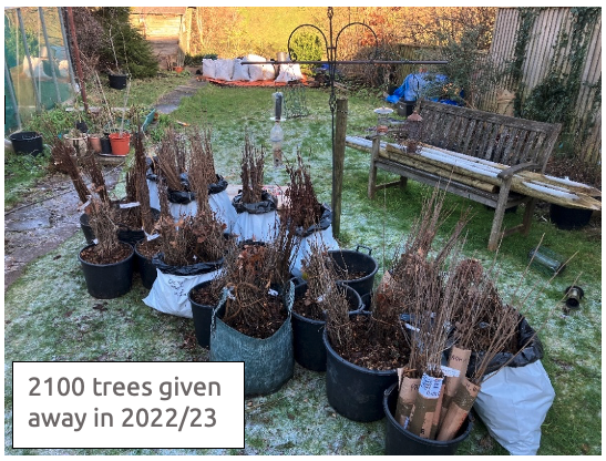
As well as advocating the retention of life-saving trees in our city, Bristol Tree Forum have been encouraging tree planting by holding an annual tree giveaway since 2020. In that year we purchased 1600 oak saplings from Maelor Forest Nurseries which we distributed free of charge. In 2021/2022 we initially gave away 600 white birch and 400 alder, as well as 900 oak saplings, the latter thank to a partnership with the Arkbound Oakupy project. We were then contacted by the Forest of Avon Trust who had a surplus of 4,500 tree saplings, over 4,000 of which we distributed through our network of tree planters. Overall, that year we gave away around 6,000 trees including 1,600 oak, 740 silver birch, 860 white birch, 55 grey birch, 600 alder, 100 alder buckthorn, 950 rowan, 45 Scots pine, 60 sweet chestnut, 300 sycamore, 50 spindle and 630 wild cherry.
Trees planted in Bristol. Trees were also planted as far afield as North Wales, South Devon and Buckinghamshire, and large tree planting projects in Compton Martin, Cheddar and West Wales.
Just some of the trees given away in 2021/22
Flushed with the success of last year’s project, the Bristol Tree Forum have ordered another thousand saplings – silver birch, white (or downy) birch and, again, thanks to Maelor Forest Nurseries. As well as our own purchase, we are distributing oak saplings on behalf of the Oakupy project. All are native trees of great benefit to wildlife, and are tolerant of urban and rural conditions.
Trees can be ordered using the form below.
We will get delivery in late January, when the trees can be collected from a site in Redland, Bristol.
The saplings come bare-rooted (i.e. out of the soil) and need to be planted as soon as possible after collection, although the viability of the trees over winter can be extended by storing the trees with the roots covered in damp soil. The form below is to find out who would like to have saplings for planting and how many, and for you to provide basic contact details (email and/or phone number) for us to organise collection of the trees. Contact details will not be used for any other purpose.
Monday, 7 November 2022 starting at 6:00 pm – City Hall, College Green, Bristol
Our Agenda
Introduction from Chair, Mark Ashdown
Finding our remarkable UK & Irish urban trees – Paul Wood
Panel Discussion between Paul Wood and Andy Bryce
Our Tree Champions
Bristol’s emerging local plan
Election of officers and financial report
AOB
We are looking forward to seeing you there.
Paul Wood
Paul is the author of three books: London’s Street Trees: A Field Guide to the Urban Forest; London is a Forest; London Tree Walks: Arboreal Ambles Around the Green Metropolis and is the editor of the Great Trees of London map. He has a lifelong passion for nature, especially trees, and was formerly a trustee of the London Wildlife Trust. He is currently working on a book about 1,000 remarkable urban trees throughout the UK and Ireland, to be published by Penguin in 2023.
Paul regularly leads walks and gives talks about trees in urban areas. As well as London, Paul has led walking tours around the streets of Bath, Sheffield, Dublin and even Philadelphia.
Andy Bryce
Andy is the Trees and Woodlands Manager at Bristol City Council. He manages Bristol’s team of tree officers and is responsible for managing our existing tree stock. Andy joined BCC in November 2021 having previously worked as an arborist at The National Arboretum, Westonbirt, latterly as its Collections Manager. Andy has worked in arboriculture for over 20 years, six of which were as an arborist in Bristol. Andy’s current research interest is tree pests and diseases.
You will all have seen young trees planted in vacant tree pits in the streets of Bristol. These trees are replacement trees. There was once a tree growing there before – maybe some time ago.
These replacement trees are paid for by sponsorship, or by funds paid by Developers when they have felled trees on a building site and there is no room to replace the felled trees on the building site. In the latter case more than one tree has been “lost” – the one on the building site and the one that was previously in the tree pit.
In order to increase Bristol’s tree canopy – vital in this time of a climate emergency – we must see trees being planted in new places as well as getting all the “old” sites being filled more quickly.
Trees for Streets
To try to get this initiative going, Bristol has joined Trees for Streets.
Quotes from the Flyer for Trees for Streets
‘Bristol City Council has joined the Trees for Streetsnational street tree sponsorship scheme, which aims to plant thousands of additional trees in streets and parks across the city, by supplementing the council’s tree budgets through public and corporate sponsorship.’
and
‘Trees for Streets is the National Street Tree Sponsorship Scheme from the urban tree charity Trees for Cities, funded by the government’s Green Recovery Challenge Fund and City Bridge Trust. The project uses technology to empower people and makes it easy for residents and organisations to get involved in greening their communities.’
and
‘Our mission is to fund the planting of more than 250,000 additional street trees nationwide over the next ten years by hosting online tree sponsorship schemes on behalf of local councils and delivering local promotion and engagement activity to bring these schemes to life.’
Comment
Bristol has long had a Tree Sponsorship scheme, run by TreeBristol (part of Bristol City Council).
In the 2021/2022 planting season £456,000 was spent by Bristol Council in planting of trees. A portion of this money is retained by BCC for maintaining the trees planted 55% of this money came from mitigation funds paid by Developers who had felled trees somewhere in the city in order to build on the land released. (So, the money was not being spent on NEW trees, just on replacements).
10% of that money came from sponsorship, with 6.5% coming from private sponsorship (individuals and groups) and 3.5% coming from business sponsorship. Even then a lot of that money was spent on replacing trees which had been lost i.e., not on providing trees in new sites. It is a difficult “sum” to achieve. Money from Developers is for the replacement of trees lost to development. The Bristol Tree Replacement Standard achieves an amount for replacement trees based on the size of the trees lost. Eventually the trees may grow to a size which more than compensates for the environmental value of trees lost. But it remains true that each replacement tree goes in to a tree site that has lost a tree formerly growing there – so the Council is spared the expense of replacing lost trees that it owned.
Representatives of the Bristol Tree Forum have attended two meetings now where this new scheme has been explained and described.
The Trees for Streets scheme is not going to fund the trees, nor plant the trees, so we would have worded the sentence “Our mission is to fund the planting of more than 250,000 additional street trees…….” slightly differently with instead “Our mission is to facilitate and organise the funding of the planting of more than 250,000 additional street trees…”
The Trees for Streets scheme is similar to Bristol’s former scheme in that it will provide a web based choosing and ordering and paying for system, whereby residents and organisations and businesses can find available tree sites for planting trees in Streets and Parks.
There are differences between the Trees for Streets Scheme and Bristol’s former scheme, and they are:
Bristol’s former sponsorship scheme was largely one of replacement for trees lost. A sponsor (an individual, a group or a business) would select, from the Council’s mapping, a site where formerly there had been a tree, and would pay for its planting. New site planting came from One Tree per Child (whips) or from national grants where Bristol would win a bid for a grant and spend the money.
The new scheme hopes to facilitate, through sponsorship, the planting of a new tree in a new site. These sites have to be found, and checked for Services (underground utility provision), and then put forward in the Council mapping for planting with a tree.
Residents, and other types of sponsor, will be able to suggest new sites for trees by answering the question “Where would you like to see a tree planted?” with their own suggestions. The sponsor would need to pay for the tree, but Trees for Streets might be able to assist with organising the funding, using their funding know how.
Initially this kind of new planting of Street Trees will only be possible in streets that currently have green verges, or in new sites in Parks.
(Trees in “hard ground” – pavements, plazas, city squares, etc. will need to be planted in engineered tree pits – and that is expensive. If a sponsor (which can be an individual, a group or a business) is prepared to meet that cost, then efforts will be made to agree suitable sites and then check them for Services and other criteria, such as the width of the pavement.)
Trees for Streets has national funding and this gives it an improved platform with web support and advertising which could see many more trees sponsored. Maybe businesses reached by the advertising will see a role in supporting tree planting in the more “tree poor” areas of Bristol?
Bristol is to offer residents the option to water their sponsored tree when it is outside their property – at a reduced cost (£160/tree v £295/tree). It gives people an option at a lower cost – and it avoids trucks driving about with lots of water in a bowser. It has worked elsewhere, and Bristol is going to try it.
DEFRA has provided funds for the setting up of Trees for Streets, and maybe future DEFRA grants will be channelled through this new national scheme. Bristol has, by making individual bids, obtained grants for tree planting from DEFRA in the past, and will still want to continue to make these bids for new funding for the actual purchase and planting of trees for new sites.
Choose the location of your tree from the map or suggest a spot in a grass verge in your street or neighbourhood. The questions on the website take you through the choices.
Answer a few questions about the location and you.
If all works out your tree will be planted during the next available planting season.
Bristol Tree Forum’s Tree Champions are to be offered training from Bristol’s Tree Officers so that they can help residents, organisations and businesses with determining the suitability of sites that are suggested.