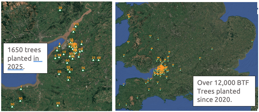
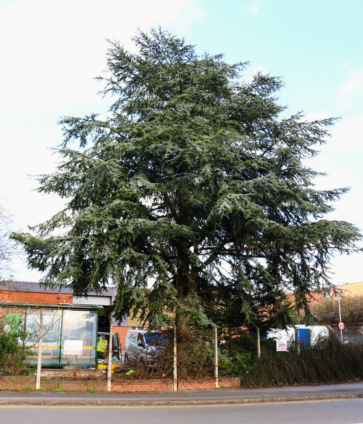
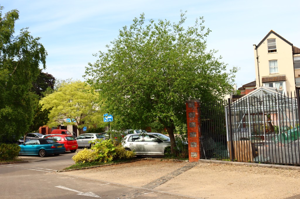
Once again, Bristol Tree Forum are giving away tree saplings. Since 2020, we have given away over 12,000 for tree lovers to plant around Bristol…. and beyond!
Our Tree Giveaway is now closed- All the trees on offer are now taken.
Perhaps one of the most significant things we can do to help protect our future environment, promote nature and make the world a better place for generations to come is to plant a tree. It may be that trees we plant today will continue to provide benefits for the environment, wildlife and people, for hundreds of years to come.
Planting trees is still the most effective and widespread means of removing CO2 from the atmosphere. For instance, a single mature oak tree is the equivalent of 18 tonnes of CO2 or 16 passenger return transatlantic flights. However, it is in our cities that trees provide the greatest benefits; cleaning our air, reducing flooding, reducing traffic noise, improving our physical and mental health, and, crucially, reducing temperatures during heat waves.
During heat waves, that are predicted to increase in both severity and frequency, the “heat island” effect can raise temperatures in cities by as much as an additional 12C over that found in surrounding rural areas. Trees can greatly reduce this effect, partly through shade but also by actively cooling the air by drawing up water from deep underground, which evaporates from the leaves… a process called evapotranspiration. According to the US Department of Agriculture, this cooling effect is the equivalent to 10 room sized air con units for each mature tree.
Thus, trees are a crucial, but often ignored, element in increasing our resilience to climate change.
The UK is one of the most nature depleted countries in the world, and have lost nearly 70% of our biodiversity since the industrial revolution. Trees are vital in supporting biodiversity. With national legislation now allowing around 60% of development sites to be exempt from the need to replace lost biodiversity, and this biodiversity permitted to be replaced anywhere in the country, our city trees are under greater threat than ever before. Furthermore, the proposed new Local Plan, which sets planning policy for the next decade or more, appears to reduce protection for Bristol’s green spaces, allowing these to be built upon.
Therefore, increasingly, it is up to us to protect nature, and what better way of doing this than to plant a tree?
What is the Bristol Tree Forum doing to help?
It is said that the best time to plant a tree is 20 years ago, and the second best time is now.
Unfortunately, important mature trees are constantly being lost to development, damage and disease. Though these might easily be replaced by new trees, what is less easy is replacing the decades or even centuries that the tree has taken to grow, the carbon that the tree has sequestered, the ecosystems the tree supports and all of the other benefits trees provide. For these reasons, much of the work of the Bristol Tree Forum focuses on protecting our existing trees. These efforts are particularly crucial in the urban environment where our trees are under the greatest threat.
However, as well as advocating the retention of life-saving trees in our city, Bristol Tree Forum have been encouraging new tree planting by holding an annual tree giveaway since 2020; the ancient trees of the future are being planted today! Most of Bristol’s trees are sited in private land and gardens, so the trees we have are mostly thanks to the efforts of Bristol residents, and it is those residents we must look to if we want to increase our tree canopy.
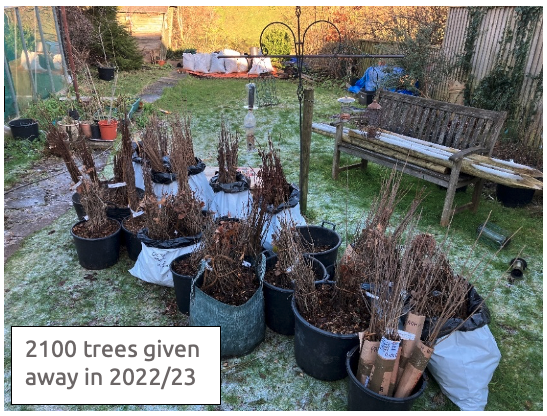
Over the last five years, we have given away over 12,000 trees, with species as diverse as English and sessile oak, downy birch, silver birch, grey birch, alder, alder buckthorn, rowan, Scots pine, sweet chestnut, sycamore, spindle, wild cherry, apple, pear and plum.
This year’s Tree Giveaway has been made possible by the generous support of Maelor Forest Nurseries, based on the Welsh borders.
Thanks to Maelor, we are able to offer a variety of species of different mature stature and preferred habitats. This year we are giving away:
English oak (Quercus robur), hawthorn (Crataegus monogyna), beech (Fagus sylvatica), hornbeam (Carpinus betulus), grey alder (Alnus incana), and crab apple (Malus sylvestris).
We will get delivery of the saplings in mid to late February, when the trees can be collected from a site in Redland, Bristol.
The small saplings, or whips, come bare-rooted (i.e. out of the soil) and need to be planted as soon as possible after collection, although the viability of the trees over winter can be extended by storing the trees with the roots covered in damp soil.
To order your tree saplings:
The Tree Giveaway is now closed- All the trees on offer are now taken.
Email: xxx with the subject “Tree Giveaway” and tell us:
Your name and email.
Your post code – for an approximate location of the planned planting sites, so that we can include these on our map.
How many of each species you would like – English oak, hawthorn, beech, hornbeam, grey alder, or crab apple.
We will email you to organise a collection date and time in February.
In a boost for the environment, new legislation now obliges most developers to set out how they will achieve at least 10% more biodiversity than already exists on their proposed development sites.
Developers must now show how they will improve the biodiversity of their development site as a result of their works. Developers must record the (baseline) on-site habitats that exist before development starts and show how they will either enhance or replace these on site. If their proposals fail to reach the 10% threshold, the developer may provide the shortfall elsewhere. This post-development mitigation should be done as closely as possible to the development site, or at least within the Local Authority. However, if this isn’t possible, they can use approved sites anywhere in England.
This approach is called the Biodiversity Gain Hierarchy (found in Schedule 7A of the Town and Country Planning Act 1990 at section 37A). The Hierarchy says it’s a priority to avoid the ‘adverse effects’ to ‘onsite habitat with a habitat distinctiveness score … equal to or higher than four.’ If this can’t be avoided, only then is mitigation permitted. In our experience, nearly all developers ignore the requirement to avoid adverse effects and move straight on to mitigation.
Since the introduction of the Bristol Tree Replacement Standard in 2013, developers (and planners) have ignored the policy requirement to avoid tree removal where at all possible. Instead, they’ve moved straight on to providing compensation for the trees lost to the development. As a result, the money set aside for replacement tree planting was not spent (on occasion reaching nearly £1 million) and many of the lost trees were never replaced.
Under the Hierarchy, habitats that score four are designated as having medium distinctiveness. While many habitats have medium distinctiveness, many don’t. For example, managed grassed areas (called ‘modified grassland’) are often found on urban sites but have a low distinctiveness score. So, too, do many other urban habitats such as allotments and gardens. Developers are not required to avoid harming these, though losses to these habitats must still be mitigated.
There’s no definition of what an ‘adverse effect’ is or any guidance on how it is assessed. However, recent advice from the Bristol’s Chief Planner about the meaning of ‘harm’ suggests that this could be interpreted very broadly or simply ignored because some sort of mitigation will always be available.
In the last extreme, developers may purchase biodiversity credits. We wait to see how this and the offsite biodiversity mitigation market evolves, but a 2012 paper published in the Harvard Environmental Law Review suggests that such environmental markets are prisoners of their own geography because the space available is always constrained:
Markets for water quality, biodiversity, endangered species, fisheries, air quality, and aquatic resources, to name a few, must recognize that the commodities they trade exist at particular geographic scales, and set appropriate spatial limits on the redistribution of environmental quality. The size of geographic trading areas has significant implications for the economic viability of markets and the ecological quality of their offsets.
This will be a particular challenge when providing biodiversity mitigation in urban areas.
The squeeze on green spaces
Land use in Bristol is subject to intense competition by many stakeholders. This is especially true for our green and open spaces, which offer many ‘services’ beyond just habitat provision. There is very little, if any, space available for new biodiversity to be created. At best, some green spaces might be enhanced, but opportunities to do this are likely to be very limited.
For example, Bristol Tree Forum’s examination of the three proposals to develop Bedminster Green shows that, if these proposals are allowed, then nearly 400 new trees will need to be planted to compensate for the lost tree habitat – a medium distinctiveness habitat. There’s no room to plant these trees on site, so offsite provision will be needed. There are very few opportunities for doing any new tree planting (as opposed to replacing lost trees) in the surrounding wards or even across Bristol, let alone, as is usually required, within a mile of a development site.
Instead, these replacement trees will have to be planted somewhere else: ‘in some foreign field that is forever Bristol’. This will inevitably lead to a net loss of biodiversity across the city as nature is ‘hollowed out’. This is unacceptable. The whole purpose of the new biodiversity gain regime is to improve overall local biodiversity, but it seems inevitable that Bristol will instead see a steady, inexorable decline.
We are disappointed that the current draft of the new Local Plan addresses none of these issues and have said so in our responses to the latest consultation:
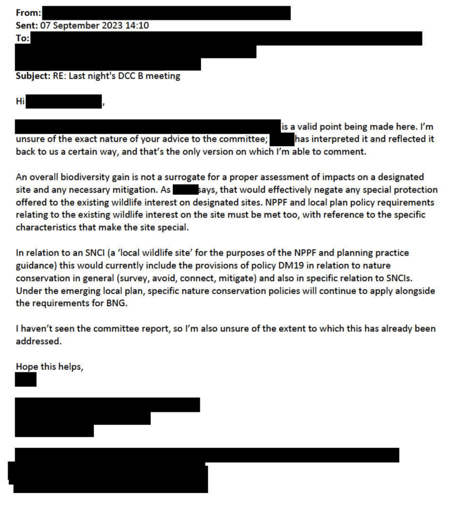
When the Development Control Committee last met to discuss the Council’s application to extend the cemetery at South Bristol into the SNCI at Yew Tree Farm on 6 September 2023, we were disturbed to hear the Chief Planner’s interpretation of the meaning of ‘harmful impact’, as set out in the Local Plan policy, DM19 – ‘Development which would have a harmful impact on the nature conservation value of a Site of Nature Conservation Interest will not be permitted.’
As we received no reply at the time, we took the opportunity to ask again when the Committee reconvened to make its decision on 29 November 2023. We asked two questions – see page 9 of the Public Forum. As the responses still didn’t really satisfy, we asked two supplementary questions:
When you say, ‘the site’, what do you mean? Is it within the redline boundary or something else such as within the SNCI’s boundary?
You say ‘The crucial additional clarification to highlight, is that to be in alignment with this policy it is NOT the overall biodiversity gain that is determinative. There rather needs to be an assessment that establishes whether there is harm with reference to the specific characteristics that make the site special.’
Does this mean that the replacement of one habitat which forms part of the ‘specific characteristics that make the site special’ – such as a replacing the Grassland Habitat that forms part of the current SNCI designation with a Lake Habitat that does not form part of the current SNCI designation, or that the provision of offsite mitigation measures to compensate for onsite habitat losses (in this case -6.44%) – would not be acceptable?
These were the replies:
To question 1
By ‘the site’, it’s the site as set out in the application document, so it’s the SNCI as contained in the application document the area in the redline boundary.
To question 2 (as it is quite complex, we have reproduced it verbatim)
You need to take the application as a whole and where it is demonstrated as that with regard to the features, particularly the grassland, that there is no impact ultimately or, if anything, a slight enhanced impact.
We intervened to ask – So you are saying that the substitution of the grassland habitat for a lake habitat…?
I am not saying that at all, I am saying that the grassland, actually that there is more grassland and that’s what the ecology report also says – more grassland of the type for which the SNCI is designated will be there through this application than before… within the redline boundary.
Anyone who wants to develop land must produce a location plan of the area proposed for development, delineated by a red line – the so-called ‘redline boundary’.[1]
When planning permission is granted, only the area within the redline boundary may be developed (though ancillary works may take place elsewhere).
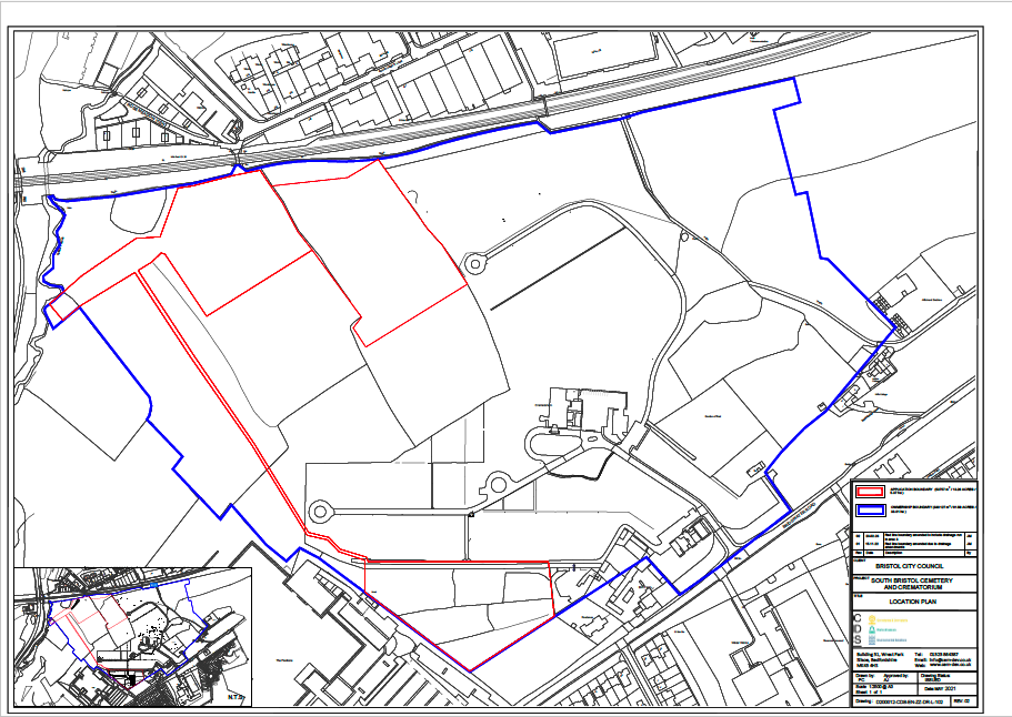
Here is the location plan for the South Bristol Cemetery Extension application:
The South Bristol Cemetery Extension location plan (North is at the top)
The redline boundary here is quite complex because it’s made up of two burial areas, in the north and south, and an attenuation pond to collect runoff from the northern burial ground through a series of drains (the southern burial ground runoff will drain straight into Colliter’s Brook to the west). The area within the blue line is also owned by the Council and so is under their control.
The redline boundary is also important when it comes to calculating the biodiversity value (BNG) of the development site. All the habitats within the redline boundary are treated as ‘onsite’, while those outside the boundary are treated as ‘offsite’.
So, when we are told that ‘… there is more grassland and that’s what the ecology report also says – more grassland of the type for which the SNCI is designated will be there through this application than before… within the redline boundary,’ it’s just the onsite area that’s being referred to. This is important, as we show below.
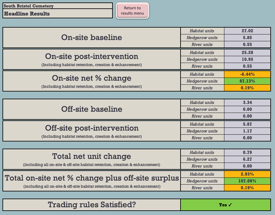
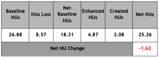
The headline results shown in the most recent BNG 3.1 calculation relied on by the Council[2] show that 6.44% of the baseline onsite area biodiversity will be lost as a result of the development (see Figure 1).
Figure 1: The BNG 3.1 Headline BNG results.
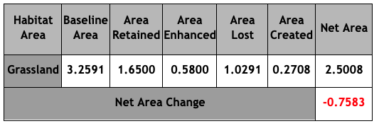
Figure 2 shows the net losses of the onsite grassland habitat:
Figure 2: Grassland Area & Habitat Unit analysis (HUs)
Under the BNG Trading Rules, Medium Distinctiveness grassland habitats may only be replaced with the other Medium Distinctiveness grassland habitats or with habitats of a Higher Distinctiveness. So, in order to achieve the net 2.93% BNG which the Council claims will result from the development, it will be necessary to compensate for these losses by crediting 3.25 Habitat Units of High Distinctiveness Lakes habitat by creating the attenuation pond.
This is not what we are told is happening and it certainly cannot be said that: ‘… there is more grassland … of the type for which the SNCI is designated … within the redline boundary,’ This is plainly untrue and, even on the Chief Planner’s definition (which we do not accept), it is clear that this application will ‘have a harmful impact on the nature conservation value of a Site of Nature Conservation Interest.’ This is contrary to DM19.
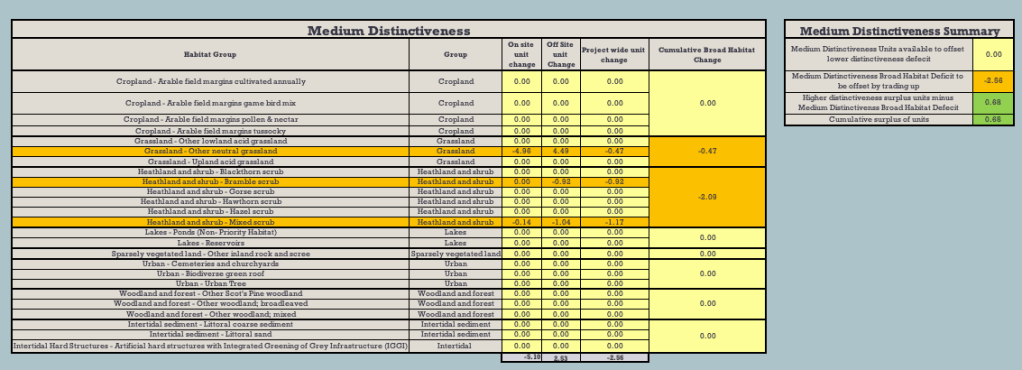
What’s more, even if the proposed offsite habitat mitigations were taken into account, there’d still be a net loss of -0.47 HU of Medium Distinctiveness grassland habitat (see Figure 4 below).
Figure 4: Net Medium Distinctiveness habitat losses
There’s one other serious flaw in the application, which was not brought to the attention of the Development Control Committee at its meeting. There’s a shortfall of -0.11 Habitat Units of the High Distinctiveness habitat, Species-rich native hedgerow with trees. Lost High Distinctiveness habitats may only be replaced like-for-like. This has not happened. As a result, the application is in breach of the BNG Trading Rules and should not have been approved.
We have brought this to the attention of the Council and the LPA.
These are just some of the important reasons why we say that the Development Control Committee was wrong to grant this flawed application.
We were very disturbed to hear your advice to Councillor Pearce at last night’s Development Control Committee B meeting to consider the expansion of South Bristol Cemetery on to land used by Yew Tree Farm, a Site of Nature Conservation Interest (SNCI). You advised Councillor Pearce that the definition of ‘harm’ under SADMP DM19 was based on the net (not gross) harm caused after mitigation had been considered.
You seemed to be using Biodiversity Net Gain (BNG) as the proxy for harm, so that the reported net gain of nearly 3% was sufficient to conclude that there was no ‘harmful impact’ as defined by DM19.
Bristol Local Planning Policy DM19 plainly states that ‘Development which would have a harmful impact on the nature conservation value of a Site of Nature Conservation Interest will not be permitted.’ It could not be clearer.
If your interpretation of this is correct (and we say it cannot be), it will effectively nullify any policy protection for SNCIs or indeed, any other existing green infrastructure and all SNCIs could be developed in a free-for-all. We set out our reasoning below.
The Mitigation Hierarchy
The Mitigation Hierarchy, as enshrined at paragraph 180 a) of the NPPF, states:
When determining planning applications, local planning authorities should apply the following principles:
a) if significant harm to biodiversity resulting from a development cannot be avoided (through locating on an alternative site with less harmful impacts), adequately mitigated, or, as a last resort, compensated for, then planning permission should be refused;
On your interpretation, the first element of this cascading test, avoidance, will never have to be applied. Instead, you need only consider the second element, mitigation, for it is only then that ‘harm’ can be assessed. This cannot be the intention of this provision.
Green spaces protection
The effect of your approach is to make a nonsense of the prohibition against causing any ‘harmful impact’ to an SNCI as conferred by DM19. It effectively nullifies the special protection given to these sites. Here is the full DM19 policy wording:
On your interpretation, the whole section relating to Sites of Nature Conservation Interest may as well be deleted, as it adds nothing to the more general policy set out above.
The section relating to wildlife corridors is also rendered meaningless if there can now be no net ‘harmful impact’.
The same conclusion must also apply to the protection of Urban Landscapes under SADMP DM17, another feature which ‘contributes to nature conservation in Bristol’, on your interpretation. Your interpretation might also be extended to the other Existing Green Infrastructure identified in DM17.
Achieving BNG means there is no ‘harm’
When the Environment Act 2021’s requirement for all developments to achieve at least 10% biodiversity net gain takes effect later this year, it must follow that schemes which achieve this will have caused no ‘harm’ under your definition.
How then should this be interpreted if the net gain can only be achieved through offsite mitigation (as will often be the case)? Even in this scenario, it seems that there can never be any circumstance where an SNCI can suffer a harmful impact because it must always be mitigated by the requirement to achieve at least 10% BNG. It is even possible to imagine that the SNCI status of the target site will be lost as a result of the development, yet, as you see it, this will not be ‘harm’.
You are in effect stating that no SNCI in Bristol now has any greater protection than any ‘other habitat, species or features, which contribute to nature conservation in Bristol’ and the whole special status of SNCIs has become meaningless.
This cannot be what was intended when SNCIs were created and given special protection under the Local Plan.
We urge you to reconsider your advice.
Our statement to the Planning Committee can be read here.
A small grove massacred to the last ash,
An oak with heart-rot, give away the show:
This great society is going to smash;
They cannot fool us with how fast they go,
How much they cost each other and the gods.
A culture is no better than its woods.
W.H. Auden from ‘Bucolics, II: Woods’
Nearly six weeks ago, on 17 April, our hopes of preserving our beloved Brislington Meadows were dashed. Homes England has been allowed to continue with its plans to use the land for housing. The almost universal cry of ‘No!’ from across the city has fallen on deaf ears; Homes England will carry on regardless.
But we haven’t given up. We have all – The Bristol Tree Forum, Greater Brislington Together and Save Brislington Meadows Group – been searching high and low to find a way to stop this, even at the eleventh hour. And we’ve succeeded! We’ve found serious omissions in the planning inspector’s decision which, we believe, give us grounds to have it overturned.
Here’s a summary of the reasons why we think the decision should be set aside. They are a bit technical, but they are important:
The Inspector’s Decision has entirely missed the fact that part of the site – part of the proposed vehicle access at the north-west corner to Broomhill Road, with a strip of housing development there (the only viable point of access onto the development site) – is designated in the adopted Site Allocations and Development Management Policies (SADM) as ‘Important Open Space: Belroyal Avenue, Brislington’.
SADM policy DM17 states: ‘Development on part, or all, of an Important Open Space as designated on the Policies Map will not be permitted unless the development is ancillary to the open space use.’ The failure to have regard to this clear conflict with policy was a breach of s.38(6) and s.70 of the Planning and Compulsory Purchase Act 2004. It’s notable that this part of the site is outside of the Site Allocation, discussed below, which the Inspector placed so much weight on.
What’s more, this same part of the development was confirmed by the Council as a public open space called Belroyal Avenue Open Space in its 2008 Bristol Parks and Green Space Strategy. Because of this and its historic use for recreation, the site is protected by a statutory trust under s.10 of the Open Spaces Act 1906. However, when this land was sold to Homes England in March 2020, the Council failed to meet the requirements of s.123(1) and (2A) of the Local Government 1972. As a result, the site remains subject to the statutory trust, held for the enjoyment of the public, and may not be developed. The principle of the statutory trust was recently confirmed by the Supreme Court in the case of Day v. Shropshire. Even though this case was not brought before the planning inspector (it was published only three days before our three-week planning appeal ended), the legal principle at the heart of it was a material consideration that should have been taken into account in the Inspector’s 17 April decision. This is especially so, given the earlier 1 November 2016 Cabinet decision (item 12) to ignore the 2012 decision of the Greater Brislington Partnership not to declare this land surplus to their Green Space requirements and decide that the land should be sold anyway. Site ‘1’ on map N5954e – which was available when the Cabinet met in November 2016 – clearly shows the Belroyal Avenue Open Space as owned by the Council and subject to its 2008 Bristol Parks and Green Space Strategy designation.
The Brislington Meadows Site Allocation policy, BSA1201 (at page 154), states that ‘the development should retain or incorporate important trees and hedgerows within the development which will be identified by a tree survey.’ The Inspector identified a number of ‘relatively important trees for the purposes of BSA1201’ which would be lost. To allow this must be a breach of the BSA1202 requirement. Despite this, they then found compliance with the policy. This is irrational, as is the fact that they judged that ‘broadly speaking, the most important hedgerows would see the most retention’. This must mean that some of the other most important hedgerows will be lost. This is also in conflict with BSA1201.
Compliance with BSA1201 is also used to reduce significantly the weight accorded to the breach of DM17 in respect of the requirement to integrate important existing trees. This gives another ground of challenge in relation to the Inspector misinterpreting the criterion in BSA1201 and/or irrationally failing to acknowledge that the loss of important trees and hedgerows constitutes a breach of BSA1201, being compounded by a consequential reduction in weight accorded to the conflict with DM17.
For all these reasons, we’ve a strong case to make to overturn the inspector’s decision. Time is running out, though – we only have until this coming Friday, 26 May, to issue proceedings. It is tight, but we could do it. But we’ll need to find at least £50,000 to bring and argue our case.
No doubt Homes England would be determined to fight us all the way and, whilst they seem to have access to almost limitless public funds and can afford the most expensive lawyers, we don’t. We’re just a group of local volunteers doing the best we can to save this precious green space. We don’t have much money – certainly not £50,000! Any money we can raise will depend on the generosity of the public. This is a big ask, especially as times are hard and money is tight. Also, should we lose (and we could), Homes England will want their costs paid as well. This is just too much of a risk.
We’ve written to the Council asking if they plan to challenge the decision and have said why we think they have a case. Sadly, we’ve had no answer. We suspect they’ll be reluctant to do so and expose themselves, yet again, to criticism for their mistakes and misjudgements. This is perhaps especially true given that, as well as losing the appeal, the Inspector has also ordered them (actually, us tax payers) to pay a large part of Homes England’s appeal costs.
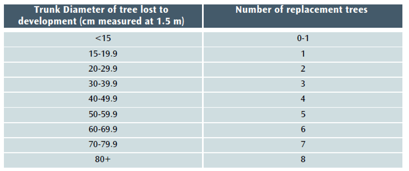
The Bristol Tree Replacement Standard (BTRS), which was adopted nearly a decade ago in 2013, provides a mechanism for calculating the number of replacements for any trees that are removed for developments. It was ground-breaking in its time as it typically required more than 1:1 replacement.
The presumption should always be that trees should be retained. The application of BTRS should only ever be a last resort. It should not be the default choice, which it seems to have become.
The starting point for any decision on whether to remove trees (or any other green asset) is the Mitigation Hierarchy[2] which states, firstly, avoid; then, if that is not possible, minimise; then, if that is not possible, restore; and, as a last resort, compensate (the purpose or BTRS). BCS9 adopts this approach and states that:
Individual green assets should be retained wherever possible and integrated into new developments.
However, with the emergence of a new Local Plan for Bristol, we believe that the time has come for BTRS to be revised to reflect our changing understanding of the vital importance of trees to the city in the years since the last version of the Local Plan was adopted in 2014.
In addition, Bristol has adopted Climate and Ecological Emergency Declarations so a new BTRS will be an important part of implementing these declarations. Nationally, the new Environment Act 2021 (EA 2021) is coming into force late next year.
Our proposal provides a mechanism for complying with the new legal requirement for 10% Biodiversity Net Gain (BNG) which will be mandatory when EA 2021 takes effect.
Background
Under current policy – BCS9 and DM17 – trees lost to development must be replaced using this table:
Table 1 The Current BTRS replacement tree table
However, when the balance of the Environment Act 2021 (EA 2021) takes effect late in 2023, the current version of BTRS will not, in most cases, be sufficient to achieve the 10% biodiversity net gain (BNG) that will be required for nearly all developments. Section 90A will be added to the Town and Country Planning Act 1990 and will set out the level of biodiversity net gain required ( Schedule 14 of the EA 2021).
The Local Government Association says of BNG that it:
…delivers measurable improvements for biodiversity by creating or enhancing habitats in association with development. Biodiversity net gain can be achieved on-site, off-site or through a combination of on-site and off-site measures.[3]
GOV.UK says of the Biodiversity Metric that:
where a development has an impact on biodiversity, it will ensure that the development is delivered in a way which helps to restore any biodiversity loss and seeks to deliver thriving natural spaces for local communities.[4]
This aligns perfectly with Bristol’s recent declarations of climate and ecological emergencies and with the aspirations of the Ecological Emergency Action Plan,[5] which recognises that a BNG of 10% net gain will become mandatory for housing and development and acknowledges that:
These strategies [the Local Nature Recovery Strategies] will guide smooth and effective delivery of Biodiversity Net…
Our proposed new BTRS model
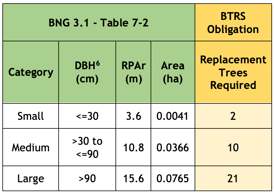
We propose that the Bristol Tree Replacement Standard be amended to reflect the requirements of the EA 2021 and BNG 3.1 and that the BTRS table (Table 1) be replaced with Table 2 below:
Table 2 The proposed new BTRS tree replacement table
The Replacement Trees Required number is based on the habitat area of each of the three BNG 3.1 tree categories (Table 7-2 below) divided by the area habitat of one 30-year old BNG 3.1 Small tree (Table 3 below) plus 10% net gain. This is rounded up to the nearest whole number since you can’t plant a fraction of a tree.
The reasoning for our proposal is set out below:
Applying the Biodiversity Metric to Urban trees
The most recent Biodiversity Metric (BNG 3.1) published by Natural England, defines trees in urban spaces as Urban tree habitats. The guidance states that:
the term ‘Urban tree’ applies to all trees in urban situations. Urban trees may be situated within public land, private land, institutional land and land used for transport functions.
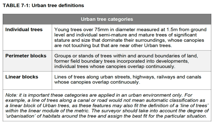
Table 7-1 divides Urban tree habitats into three categories:
Paragraph 8.5 of the 3.1 BNG Guidance makes it clear that lines of trees in an urban environment should not be treated as a linear habitat:
Urban trees are considered separately to lines of trees in the wider environment, since they generally occur in an urban environment surrounded by developed land.
Calculating Urban tree habitat
Urban tree baseline habitat area is measured in hectares and is based on the Root Protection Area[7] (RPA) of each tree impacted by a proposed development. RPA is used instead of tree canopy because it is considered to be the best proxy for tree biomass.
In most cases, RPA is obtained from an Arboricultural Impact Assessment (AIA), which complies with British Standard 5837 2012 – Trees in relation to design, demolition and construction (BS:5837).
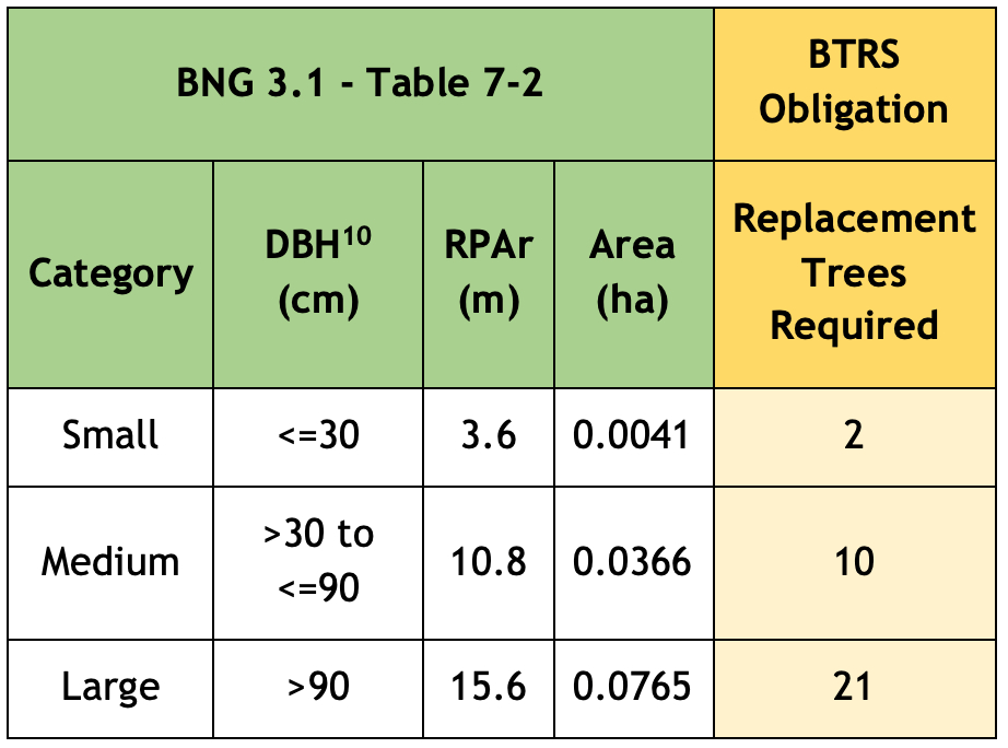
Where no AIA is available, Table 7-2 is used:
Note that the tree’s size will still need to be ascertained, and that any tree with a stem diameter (DBH) 75mm or more and of whatever quality (even a dead tree, which offers its own habitat benefits) is included . Under BTRS, trees with a DBH smaller than 150 mm are excluded, as are BS:5837 category “U” trees.
The guidance also makes it clear that, given the important ecosystem services value provided by trees, where possible like-for-like compensation is the preferred approach, so that lost Urban trees are replaced by Urban trees rather than by other types of urban habitat.[8]
Replacing lost trees
To calculate the number of trees required to replace Urban tree habitat being lost, table 7-2 above is used on this basis:
Size classes for newly planted trees should be classified by projected size at 30 years from planting.
We have used the median DBH sizes for new stock trees as set out in BS 3936-1: Nursery Stock Specification for trees and shrubs as the basis for calculating the eventual size of a newly planted trees after 30 years and assumed that a tree adds 2.54 cm (1”) to its girth annually.
This results in a predicted stock tree size after 30 years’ growth. This is then assigned to one of the three Urban tree categories set out in table 7-2: Small, Medium or Large. In all cases save for Semi-mature tree stock, the eventual size of stock trees after 30 years falls within the BNG 3.1 size category Small, which has a habitat area of 0.0041 hectares. This value is then used to calculate how many new trees will be required to replace trees lost to the development, plus a 10% biodiversity net gain. This gives a compensation size per replacement tree of 0.0045 ha (0.0041 hectares + 10%).
Table 3 below shows the basis our our calculation:
Table 3 Annual stock tree growth predictions
The Trading Rules
It may be that a notional positive biodiversity net gain can be achieved by replacing fewer trees than this analysis indicates. However, this is not enough. The calculation should also comply with the Trading Rules that apply to Urban tree habitats.
Paragraph 7.6 of the 3.1 BNG Guidance states:
The mitigation hierarchy and trading rules apply to Urban trees. Given Urban trees are a ‘Medium’ distinctiveness habitat, trading rules stipulate that the same broad habitat type (or a higher distinctiveness habitat) is required. However, given the important ecosystem services value provided by trees, where possible ‘like for like’ compensation is the preferred approach (i.e. where possible any loss of Urban trees should be replaced by Urban trees – rather than other urban habitats).
Rule 3 of the User Guide states: ‘”Trading down’ must be avoided. Losses of habitat are to be compensated for on a ‘like for like’ or ‘like for better’ basis. New or restored habitats should aim to achieve a higher distinctiveness and/or condition than those lost…’
The likely impact of this policy change
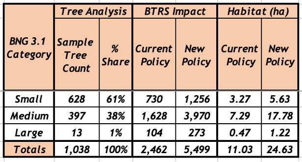
We have analysed tree data for 1,038 surveyed trees taken from a sample of AIAs submitted in support of previous planning applications. Most of the trees in this sample, 61%, fall within the BNG 3.1 Small range, 38% within the Medium range, with the balance, 1%, categorised as Large.
Table 4 below sets out the likely impact of the proposed changes to BTRS. It assumes that all these trees were removed (though that was not the case for all the planning applications we sampled):
Table 4 Proposed BTRS impact analysis
The spreadsheet setting out the basis of our calculations can be downloaded here – RPA Table 7-2 Comparison.
This article was amended on 7 November 2022 to include references to Lines of Trees in the urban environment, the application of the Trading Rules to Urban tree habitats and fix a broken link.
Appendix 1
Our proposed changes to BTRS, set out in the Planning Obligations Supplementary Planning Document, page 20.
Trees – Policy Background
The justification for requiring obligations in respect of new or compensatory tree planting is set out in the Environment Act 2021, Policies BCS9 and BCS11 of the Council’s Core Strategy and in DM 17 of the Council’s Site Allocations and Development Management Policies.
Trigger for Obligation
Obligations in respect of trees will be required where there is an obligation under the Environment Act 2021 to compensate for the loss of biodiversity when Urban tree habitat is lost as a result of development.
Any offsite Urban tree habitat creation will take place in sites which are either on open ground or in areas of hard standing such as pavements.
Where planting will take place directly into open ground, the contribution will be lower than where the planting is in an area of hard standing. This is because of the need to plant trees located in areas of hard standing in an engineered tree pit.
All tree planting on public land will be undertaken by the council to ensure a consistent approach and level of quality, and to reduce the likelihood of new tree stock failing to survive.
Level of Contribution
The contribution covers the cost of providing the tree pit (where appropriate), purchasing, planting, protecting, establishing and initially maintaining the new tree. The level of contribution per tree is as follows[9]:
Tree in open ground (no tree pit required) £765.21
Tree in hard standing (tree pit required) £3,318.88
The ‘open ground’ figure will apply where a development results in the loss of Council-owned trees planted in open ground. In these cases, the Council will undertake replacement tree planting in the nearest appropriate area of public open space.
In all other cases, the level of offsite compensation required will be based on the nature (in open ground or in hard standing) of the specific site which will has been identified by the developer and is approved by the Council during the planning approval process. In the absence of any such agreement, the level of contribution will be for a tree in hard standing.
The calculation of the habitat required to compensate for loss of Urban trees is set out in Table 7-2 of the Biodiversity Metric (BNG), published from time to time by Natural England. This may be updated as newer versions of BNG are published.
The following table will be used when calculating the level of contribution required by this obligation:
[6] DBH = Diameter at Breast Height. RPAr = Root Protection Area radius. Area = the calculated BNG habitat area.
[7] RPA area = π × r2 where r is 12 x the tree’s DBH for a single stemmed tree. For multi-stemmed trees, the DBH of the largest stem in the cluster should be used to determine r.
[9] These values should be updated to the current rates applicable at the time of adoption. The current indexed rates as of April 2022 are £1,041.6 & £4,517.89 respectively.
[10] DBH = Diameter at Breast Height. RPAr = Root Protection Area radius. Area = the calculated BNG habitat area.
However, a consequence of the adoption of this motion is that there is greater pressure to develop on other sites. Those advocating development on open spaces within Bristol have begun, arbitrarily and without proper justification, to declare such open spaces to be brownfield. To inaccurately describe a development site as brownfield places Development Committee members under undue pressure to approve a planning application when, as greenfield, a site should fall under the additional protection engendered by the landmark motion.
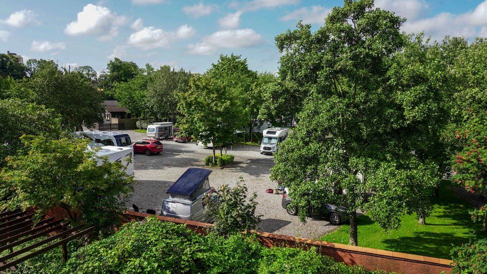
Baltic Wharf Caravan Park
Recent examples (see below) where the term brownfield has been misused are the Bristol Zoo Gardens car park on College Rd, Clifton and the Baltic Wharf Caravan Park on the Floating Harbour in Hotwells, each of which have been mislabelled as brownfield sites despite not falling within with the recognised legal definition.
Bristol Zoo Gardens car park
The term brownfield site is used to describe certain types of previously developed land. Most dictionary definitions refer to this land as being currently or previously occupied by a permanent structure which generally includes the potential for contamination. In planning law there is a definition which must apply when considering planning proposals. This is detailed in the National planning policy framework (NPPF – called ‘Previously developed land’, p.70) as:
“Land which is or was occupied by a permanent structure…. and any associated fixed surface infrastructure”.
The definition excludes land which is maintained as a garden:
“….. land in built-up areas such as residential gardens, parks, recreation grounds and allotments…“
In addition to the definition, there is a statutory requirement for local authorities to maintain an up to date register of brownfield sites which are appropriate for development:
The Town and Country Planning act also addresses the situation where a fragment of the site might be considered brownfield, but other parts of the curtilage is green space:
“Greenfield land is not appropriate for inclusion in a brownfield land register. Where a potential site includes greenfield land within the curtilage, local planning authorities should consider whether the site falls within the definition of previously developed (brownfield) land in the National Planning Policy Framework. Where it is unclear whether the whole site is previously developed land, only the brownfield part of the site should be included in Part 1 of the register and considered for permission in principle”.
Mislabelling as brownfield examples in recent planning applications
Bristol Zoo Gardens car park, College Rd, Clifton (21/01999/F)
The planning proposal makes the statement “The application site is brownfield, previously developed land, as it is a car park“. Mayor Marvin Rees similarly defined the site in a subsequent tweet criticising some members of the Development Committee for voting against the proposal.
This site fails to comply with the proper planning definition of a brownfield site. In relation to the NPPF definition, 7.4% of the site is occupied by buildings whereas tree canopy covers about 17% of the site. Much of the site is covered by unfixed surface, which does not qualify under the definition of a brownfield site. Therefore, according to the Town and Country Planning Act only 7.4% of the site could be considered brownfield, with the remaining 92.6% being classified as greenfield. The site does not appear on the Council’s register of brownfield sites, and therefore cannot legally be classified as such.
This planning proposal has also been inappropriately described as a brownfield site in the planning application. Only 2.6% of the site is occupied by a permanent structure, whereas the 100 trees that occupy this site cover over 30% of its area. Thus, only 2.6% of the site could possibly be defined as brownfield, with the remaining 97.4% falling under the classification of greenfield. Furthermore, as much of the site is maintained as a “residential garden”, the site is exempt from the NPPF definition. This site, also, is absent from the necessarily up-to-date register of brownfield sites.
Whilst there may be arguments to develop some parts of some of these sites, the existing trees should be retained in order to comply with Local Planning Policy BCS9. The current approach of flattening all trees, including those on the edge of the site results in third rate developments. Instead, new developments should be built around existing trees.
Petition
If you agree that this mislabelling should stop, please sign this petition to protect Bristol’s green spaces from the Council’s mislabelling of them as “brownfield sites”:
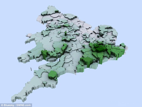
“Bristol ranks as the 5th greyest city in England”
This statement was made in a recent article in Wales Online, the Express, and elsewhere. The article, with a by-line of Neil Shaw, seems to be based on a press release by OVO Energy who are promoting a petition to create a legally binding target to plant 30,000 ha of new woodland each year to 2050. The article reported tree cover in a number of countries and cities around the UK based on data supplied by the aerial survey and GIS company BlueSky. Amongst the results is :
Bristol, known for its green credentials, ranks as the 5th greyest city in England at 8% – and only 1 tree per person.
This is very different from the estimate produced by our own tools which estimate tree canopy cover (TCC) in 2020 at around 17.5%. Thankfully, as the following analysis discovers, Bristol can hold its head as a green city.
i-Tree Canopy
Our estimate is based on a desktop survey using a methodology called i-Tree Canopy. The methodology is pretty simple: take any boundary, randomly place a number of points within the boundary, examine each point in Google Maps and decide if the point lies within a tree canopy or not; the ratio of canopy points to the total number of points is the TCC, Uncertainty arises from the nature of the random sampling and interpretation of the image, particularly to distinguish a tree from hedges and low ground cover.
Our version of this approach is integrated with the Trees of Bristol website so that it can used to estimate TCC for any area in our database with a known boundary. In particular, we have used this tool to estimate TCC for all wards in Bristol which are mapped here. These values have joined the many hundreds of estimates across the UK to form the GB Ward Canopy Map organised by Forest Research. With this pedigree, we have been advocating this approach for use in Bristol as the means to assess progress towards Bristol’s ambitious goal of doubling tree canopy by 2046. Aggregating the samples across all 32 wards, we estimated that Bristol had 17.9% TCC in 2018 and by 2020 it was 17.5%. (This change from 2018 to 2020 is not statistically significant)
National Tree Map
The estimates in the press article were based on the National Tree Map, a commercial product from Bluesky. This uses a combination of their own imagery and LIDAR data. Complex analysis of the LIDAR data, using the difference in return time from ground and canopy reflections enables an estimate of the canopy above 3m high.
Discussion with Bluesky revealed a probable cause of the discrepancy for Bristol. Any comparison between estimates needs to be based on the same boundary definition using imagery from the same time period. For the i-Tree Canopy approach we have used the City of Bristol boundary which has an area of about 11,000 hectares (110 sq km) . In contrast, it turns out that the data provided to OVO energy by Bluesky was based on the Unitary Authority Boundary. For Bristol this is a rather odd area, taking in a swath of the Bristol Channel down as far as the islands of Flat Holm and Steep Holm. This is because historically, the boundary of the Port of Bristol is included.
The area within this boundary is 23,500 hectares. Since Bristol can hardly be criticised for failing to plant trees in the Bristol Channel, this dramatically distorts the estimate. Adjusting for this difference in definition, I arrived at a figure of 17%, within the statistical bounds of the i-Tree canopy estimate.
The National Tree map was also used back in 2014 as reported in the Daily Mail. The accompanying map similarly shows a very low value for tree canopy in Bristol so I suspect that the same boundary was used there too.
Comparison
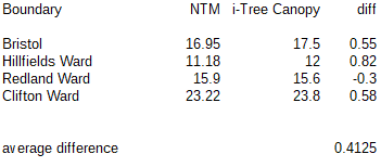
After discussion with BlueSky, I supplied four boundaries for assessment using the NTM methodology for comparison with the i-Tree approach: the Bristol City Boundary and three wards chosen to have low, medium and high levels of canopy. These are the results:
NTM uses a strict height of 3 metres when assessing canopy whereas using i-Tree canopy, the distinction between tree canopy and lower greenery including hedges is assessed visually, so a slight upward bias might be expected and has also been observed in Forest Research data. On the whole though, this comparison shows very strong agreement between the two methodologies.
The bad news
The gross error in Bristol’s tree canopy percentage actually made it easy to see that something was amiss. One must assume that similar issues will have occurred in the case of other cities whose boundaries are subject to debate. Indeed, the Unitary authority boundary for Portsmouth, which with only 4% cover is reported to the be worst in the UK, includes the expanse of Portsmouth and Langstone Harbours. According to the Portsmouth Council website, land is about two-thirds of the area of the authority so a better figure would be 6%, still low.
Problems with boundary definitions plague this data. Bristol City is only the core of the conurbation with large parts of what we think of as Bristol in South Gloucestershire and Bath and North East Somerset. Comparison with the figure given for Leeds, also 17%, is not possible since the City of Leeds boundary includes all the surrounding towns and countryside.
It is clear that unitary authority boundaries are not directly suitable for urban canopy evaluation.
The need for full data publication
In addition to the 2014 report and the recent publicity by Ovo Energy, another survey by Bluesky was publicised late last year on the BBC but no figure for Bristol is mentioned. These press articles give only selective figures rather than the full data across England. I searched for published reports containing the full data, which I expected to include the base area, canopy area as well as the computed percentage and rankings. I found nothing. This makes it impossible to correct other derived data, such as the ranking of Bristol as the “5th greyest in England”.
I would hope that in future, companies like Bluesky and Ovo Energy will see that making full data openly available in support of extracts and assertions would reduce mis-interpretations, provide a public good and better promote their company.
Journalists too have a responsibility here, not only to critically assess press releases but to request and link to the supporting data. Neither happened in this case.
The good news
This exercise has turned out to be good news for both the National Tree Map methodology and our own work with i-Tree Canopy. The results are very similar and differences are rather consistent and explainable. Our implementation of i-Tree Canopy is free to use by citizen-scientists with known error bounds and can be quickly applied to any chosen boundary. With the inclusion of historical imagery from Google Earth, it can also be used to compare canopy over time.
This exercise has also confirms the doubts we held about the figure from an i-Tree Eco survey carried out in 2018. This survey used volunteers to ground-survey 200 random plots in Bristol. The survey arrived at a figure of 12% with wide error bounds but much less than the i-Tree Canopy value. All methods have some uncertainty but we can be pretty confident that Bristol’s Tree Canopy in 2020 is in the region of 17 – 18%.
The National Tree Map is primarily intended as a means to locate and measure the canopy of individual trees in an area. The canopy estimate is only a by-product and agrees well with the i-Tree canopy approach. For its primary purpose, NTM appears to provide a very much more economic solution than on the ground surveying. Indeed it would be very interesting to compare this map for Bristol with the mapping of individual trees in Trees of Bristol.
Forest Research is at the forefront of research into the UK Urban Tree canopy and their 2017 paper on the Canopy Cover of Englands Towns and Cities remains the most authoritative UK -wide survey. We look forward to an update to this excellent work.
We delighted to report that nearly 1,600 tree orders have been received. We have bought another 600 trees to cover the extra orders and expect delivery soon.
Many thanks to all of you who have placed an order. We shall soon let you know when and where you can collect your trees.
Due to COVID-19 restrictions and delays in government funding, there has been postponements and cancellations of many major tree planting projects. As a result, large numbers of tree saplings are due for destruction in tree nurseries. This includes 750,000 two year old English oak tree saplings at the Maelor Forest Nursery in Wrexham.
Rather than see these trees destroyed, Bristol Tree Forum has purchased 1,000 of the oak saplings for free distribution to anyone able to plant them, whether this is one tree or a hundred.
We will get delivery early in November. The trees can be collected from a site in Redland, Bristol and a few collection dates will be organised hopefully to suit all. They should be planted as soon as possible afterwards.
The saplings are between 10cm and 90cm high. They come bare-rooted (i.e. out of the soil) and need to be planted as soon as possible after collection, although the viability of the trees over winter can be extended a little by storing the trees with the roots covered in damp soil.
This form is to find out who would like to have saplings for planting and how many, and for you to provide basic contact details (email and/or phone number) for us to organise collection of the trees. Contact details will not be used for any other purpose.
Why plant a tree?
A single mature oak tree is the equivalent of 18 tonnes of CO2 or 16 passenger return transatlantic flights.
Despite advances in carbon capture technology, the most efficient and cost-effective way to sequester carbon from the atmosphere is to plant trees.
Whatever the merits of this application of achieving its primary goal to provide much needed housing may be, it should not be permitted to proceed unless and until it has properly addressed how it will replace and build upon the Green Infrastructure (including trees) that will inevitably be lost if this application proceeds as presently formulated.
Summary of our submission
We object to this application for the following reasons.
Bristol City Council has:
Declared climate and environmental emergencies.
Committed to becoming carbon neutral by 2030.
Committed to doubling tree canopy cover by 2046.
As currently formulated, these plans to build new houses can only set back the work needed to resolve these emergencies and achieve these commitments.
The need to build housing to meet sustainable economic or social development objectives should not be allowed to take precedence over ensuring that the development is also both environmentally sustainable and meets Net Gain objectives.
Whatever the merits of this application of achieving its primary goal to provide much needed housing may be, it should not be permitted to proceed unless and until it has properly addressed how it will replace and build upon the Green Infrastructure (including trees) that will inevitably be lost if this application proceeds as presently formulated.
The existing trees have a significant asset value which should not lightly be ignored. Using CAVAT, we have valued them at £4,674,918.
Under the Mitigation Hierarchy, trees should not be removed unless there is no realistic alternative. One alternative would be to build around the trees rather than remove them.
BCS9 of the Core Strategy also states that “Individual green assets should be retained wherever possible and integrated into new development”. Clear felling nearly all the trees to the east of the cycle/footpath should not, as it so often is, be the default option.
Trees should not be removed merely because they are diseased or self-sown, or because they are small or not perfect specimens of their species.
The removal of existing trees inevitably means that the eco-services they provided will not be replaced for decades, if at all.
The adverse knock-on environmental impact on biodiversity of removing existing trees far outweighs any short-term benefits achieved by replacing them.
Our submission
The planning background
The National Planning Policy Framework
The National Planning Policy Framework (NPPF) seeks to ensure that new development is sustainable. It stresses the importance of Green Infrastructure as one of three overarching, interdependent objectives – economic, social, and environmental. This means that the presumption in favour of sustainable environmental development is just as important as any in respect of economic or social development objectives.
Trees are an integral part of this because of the importance of trees in relation to the management of air, soil and water quality along with other associated ecosystem services, climate change adaptions and beneficial health effects. The NPPF also seeks to achieve the protection and enhancement of landscapes and achieve Net Gain in biodiversity.
“approach to development that aims to leave the natural environment in a measurably better state than beforehand. This means protecting existing habitats and ensuring that lost or degraded environmental features are compensated for by restoring or creating environmental features that are of greater value to wildlife and people. It does not change the fact that losses should be avoided where possible, a key part of adhering to a core environmental planning principle called the mitigation hierarchy.”
The Mitigation Hierarchy
Avoid – Where possible habitat damage should be avoided.
Minimise – Where possible habitat damage and loss should be minimised.
Remediate – Where possible any damage or lost habitat should be restored.
Compensate – As a last resort, damaged or lost habitat should be compensated for.
This is a cascading decision process – only if the preceding choice is unavailable is the next considered.
Local Planning Authorities (LPA) in the UK have a statutory duty to consider both the protection and planting of trees when considering planning applications. The potential impact of development on all trees is therefore a material consideration. In particular, BCS9 of the Core Strategy states that “Individual green assets should be retained wherever possible and integrated into new development”.
This site covers just over six hectares. The Lockleaze Allotments (a 0.8 hectare Statutory Allotment[1]) is located to the south east of the widest part of the site. It appears to be disused. Most of the substantial trees growing on the site are growing in or around this allotment or to the north of it. We have calculated that, taken together, they cover at least 1.3 hectares of the site – a tree canopy cover (TCC) of around 20% which is well above the estimated TCC for Bristol as a whole which is just under 12%.
All our calculations, summarised below, can be examined in this linked spreadsheet.
The Arboricultural Impact Assessment Report (the AIS) dated June 2020 (based on a survey done on the 19th and 20th of September 2019) identified a combined total of 58 individual trees and 40 tree group features. The number of trees in each group is not given, so it is not possible to say how many trees in total are growing on the site.
Of all the trees growing on site 24 individual and at least 251 group trees are identified for removal. The trees growing in Groups G69 and G74 are all to be removed, but the number of trees in each group is not identified so we have not been able to include or count these in our calculations.
The only reason for given for felling these two groups is because they show evidence of Ash Dieback (Hymenoscyphus fraxineus). As the AIS recognises, the mere presence of Ash Dieback is not a sufficient reason for the removal of a tree. We oppose the removal of these tree unless it can be shown that they there is a better reason for their removal.
The CAVAT calculation
Using CAVAT we have calculated that those identified trees which have a measured stem Diameter (DBH) are worth £4,674,918. As the AIS fails to give the upper life expectancy ranges[2] of the majority of trees, we have assumed that all those trees given a 10+ or 20+ years life expectancy will survive between 40 and 80 years. This attracts a 5% discount on the base valuation. We have applied a CTI factor for Bristol of 150[3]. All the other factors are set to their default values.
The BTRS calculation
These two tree groups and five individual trees are categorised as Category ‘U’ trees under BS5837:2012 Trees in relation to design demolition and construction, and so have not been taken into account for the purpose of the Bristol Tree Replacement Standard (BTRS) calculation. A further 10 trees are also excluded from the BTRS calculation because their stem diameters are under 15 cm. We advocate that all trees identified for removal should be replaced no matter what their size.
Notwithstanding this and based on the current guidance, we have calculated the BTRS value at 455 trees as per the AIS calculation.
Net Gain calculation
No Net Gain calculation has been undertaken using BDM2 in support of this application.
We have undertaken our own BDM2 calculation in respect of just the trees surveyed in support of this application. A full calculation needs to be undertaken in respect of the whole of the site. This will inform any future decision about achieving Net Gain if this development is to be allowed to proceed.
Using BDM2, we have calculated that the combined tree canopy cover[4] of just the known, measured trees is 1.21 hectares. We have set the A-1 Site Habitat Baseline Habitat Type to Urban – Street Tree in the calculation. This assumes, amongst other things, that any replacement trees will reach maturity in 27 years and so uses a multiplier of 0.3822 to reflect this.
This gives Base Habitat Units of 5.864 and a Base Replacement value of 3.17 hectares. If we add an arbitrary Net Gain value of 10%[5], then the Base Habitat Units increases to 6.451 and the Base Replacement value to 3.49 hectares. Assuming that a 27-year-old tree has a canopy of .00403 hectares, then 866 replacement trees are needed to replace what has been removed and to achieve Net Gain.
Loss of the ecosystem services of trees
We invite you to consider the decades-long damage that felling just one tree (let alone over 277 trees) will cause by inputting the DBH of any tree identified for removal into our Tree CO2 Calculator.
As you will see, when an equivalent tree is replaced on a one-for-one basis, the lost CO2e is never recovered. Even when the largest tree (with a DBH of 100 cm) is replaced with eight trees in accordance with BTRS, it will still take some 40 years to recover the 10.4 tonnes of lost CO2e. And this is just one of the eco-services that trees provide us!
Impact on wildlife from tree loss
We endorse the following passages from the Bonnington Walk Breeding Bird Survey Report which observes at 5.2 Habitat Loss:
The Proposed Development will include the loss of scrub, trees and buildings which provide habitat for breeding birds. The extent of habitat loss is likely to include all the scrub and trees in the centre of the Site with some edge habitat along the boundaries retained…The loss of this habitat will have an impact on any birds using it for foraging or breeding at the time. The Site is located within an urban landscape with limited natural habitats. Alternative habitats are not readily available adjacent to the Site, though alternative habitat is available in the wider landscape including Stoke Park Estate and connected habitats further east. Habitat loss on Site will have an impact at a Local level by reducing breeding bird habitat in the local area…
and at 6.2.1 Habitat Loss:
Where possible, habitat loss should be avoided, and natural habitats retained. Scrub and trees are of most value to breeding birds at this Site. When natural habitats are retained these should be protected during construction to prevent damage including root compaction and knocking off or damaging over hanging limbs.
This is just one example of the likely adverse impact on wildlife resulting from these tree removal plans. There is evidence of a diverse range of both flora and fauna that likewise will also be adversely affected by the loss of these trees.
The Bristol Tree Forum – July 2020
You can find more detail about the application here:
[2] CAVAT uses six age ranges to set the discount factor.
[3] Bristol has a population of 459,300 and a land area (as opposed to the Administrative area which covers large parts of the River Avon and coastal margins) of 10,970 hectares. Using this gives a population per hectare of 41.9 (459,300/10,970) and so a CTI Index value of 150.
[4] Under BDM2 each tree’s Root Protection Area (RPA) is calculated at 12 times its stem diameter. RPA is roughly equivalent to a tree’s canopy.
[5] The choice is arbitrary chosen only for the sake of illustration. We are not advocating a Net Gain of 10%, though the concept of Net Gain implies an improvement on the base values.