When developers cannot meet their obligation to replace habitat lost within their development site, plus at least 10%, they may buy habitat units to offset this lost habitat. These habitat units are available in ‘biodiversity gain sites’.
This article was updated on 23 February 2025 to take account of the development of our new site which dynamically analyses the Biodiversity Gain Register and collates and summarises the published data:
To date, 46 of these biodiversity gain sites (BGS) have been registered in England. They provide:
1,376.7 hectares (ha) of baseline area habitat.
32.76 kilometres (km) of baseline hedgerow habitat.
11.37 km of baseline watercourse habitat.
The BGS sites cover 1,770.41 ha, though not all of this area is used for habitat improvement. 1,420.83 ha baseline habitats are made available for offsetting habitat loss caused by development elsewhere where this lost habitat cannot be replaced on the development site itself.
Distribution of biodiversity gain sites in England
19 of the 46 BGS sites are controlled by RSK Biocensus Limited as the Responsible Body but are mostly owned by Environment Bank. One other is controlled by Harry Ferguson Holdings (based on the Isle of Wight) as the Responsible Body, with the remaining sites under the control of various Local Planning Authorities (LPA) as the Responsible Body. We assume that the LPA sites have been created in order to deal with those local developments which require offsite mitigation. Nonetheless, these sites are also selling habitat to developers which require offsite mitigation but are outside the LPA boundary.
We also ask who is policing these sites to ensure that was has bee promised is being delivered? This must especially be the case for LPA sites given that the LPA cannot monitor itself?
In Bristol the LPA has delegated this function to neighbouring authorities using s.101 Local Government Act 1972 (the power for councils to delegate functions to other local authorities). – See 30 Sept 2024 Economy and Skills Committee notes – from paragraph 9. It will be interesting to see how this turns out. However, despite this, no BGS sites have yet been registered in the city, so it is hard to see how this initiative will be delivered where offsite mitigation is required.
The habitat improvement potential
These sites provide a total of 4,819.3 area baseline habitat units (HUs), 325.59 hedgerow baseline HUs and 105.6 watercourse HUs – we have assumed that all the sites have low strategic significance and that the watercourse habitats are free of encroachment.
We have been able to calculate the improved habitat units being created but not the improved habitat units being enhanced. This is because the parameters upon which these baseline habitats are being improved have not been identified.
The take up to date
So far, 31 of these 46 BGS sites have been used by 59 LPAs to allocate lost habitat caused by 85 developments. The majority of habitats are Other neutral grassland and the remainder are Lowland meadows, Traditional orchards, Floodplain wetland mosaic and CFGM, Mixed scrub, Woodland and forest and Hedgerow habitat.
To encourage developers to choose sites as close as possible to the habitat loss, they don’t need to pay a ‘spatial risk’ penalty if the biodiversity gain site is within the same Local Planning Authority (LPA) as the development. However, if the biodiversity gain site is outside the LPA for a particular development, the developer must pay a penalty when calculating the number of habitat units to be offset. If the site is in an adjacent LPA, the penalty is 25%. If it is farther away, the penalty is 50%.
Unfortunately, it appears that developers are not using BGS within their LPA areas (if available) for offsetting but are paying the spatial risk premium, though perhaps this is because they have no choice as there are no local BGS sites available.
Our analysis shows that, to date, the average distance between the centre of the LPA* where the habitat was lost and where its loss is offset is 80.1 km, with the greatest distance between loss and replacement being 344.8 km. Only six sites are within 10 km of the site of the habitat loss, while 23 are over 100 km away.
* It is difficult automatically to calculate the exact site of the habitat loss on the basis of the information provided. If at least Post Codes were provided, this would be possible.
What is particularly notable is that many of the development sites we have examined appear to be in locations where there should be ample opportunities for local habitat to be improved, but nothing has been done to realise this. Even the South Downs National Park LPA has allowed the replacement of habitat lost in two applications on the same site under its care near Petersfield to be exported to a site some 67 km away near Lewes, albeit that it is still in the National Park.
Furthermore, all 46 of the BGS sites are located on private land, in rural settings that are not easily accessible, whereas the lost habitats were largely located in built-up areas.
However, given the requirement that offsite mitigation only be delivered on registered sites, its hard to see what choice developers have apart from testing the BGS market and buying the cheapest habitats required, albeit that this may be miles from the site of the original loss.
This is still a small sample, which will grow over time so, perhaps this will change as more biodiversity gain sites become available and a clearer trend emerges. At the moment, however, the trend is not encouraging and looks like it will result in local nature, especially in urban settings, becoming hollowed out, as we feared it would when the biodiversity net gain requirements became obligatory nearly a year ago. See our article on this: ‘It seems inevitable Bristol will see a steady, inexorable biodiversity decline’
Last year we were able to provide – free of charge – over 2,000 tree saplings for tree lovers to plant in and around Bristol…. and beyond!
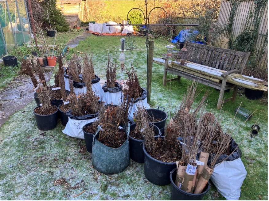
This year we plan to give away pedunculate oak (Quercus Robur) and downy birch (Betula Pubescens), each native and supporting lots of wildlife.
Would you like some to plant out in 2024? We have 2,000 to give away.
First come, first served, tho!
Stop Press – We have now distributed all available trees, so this offer is now closed. Thanks for all your support.
Watch out for our offer next year!
Few of us will forget that 2023 was the hottest year ever recorded and far exceeded previous temperature records, both locally and nationally, coming close to the average world temperature of 1.5C that we have all been challenged to avoid!
The Met Office reports that in early September 2023, the UK experienced a significant heatwave with daily maximum temperatures exceeding 30°C somewhere in the UK for seven consecutive days from 4th to 10th and reaching 31 to 32°C across south-east England. While this heatwave would not have been particularly unusual had it occurred during the high summer months (July or August), this was, for September, the longest run of days exceeding 30°C on record.
We all know the value of trees in sequestering carbon, and they still represent the most effective and widespread means of removing CO2 from the atmosphere. For instance, a single mature oak tree is the equivalent of 18 tonnes of CO2 or 16 passenger return transatlantic flights. However, it is in our cities that trees provide the greatest benefits; cleaning our air, reducing flooding, improving our physical and mental health, and, crucially, reducing temperatures during heat waves.
Our cities suffer additional problems during heat waves, with all of the concrete and tarmac absorbing a lot of energy from the sun and releasing it as heat. This “heat island” effect can raise temperatures by as much as an additional 12C. Trees can reduce, or even eliminate, this effect, partly through shade but also actively cooling the air by drawing up water from deep underground, which evaporates from the leaves… a process called evapotranspiration. According to the US Department of Agriculture, this cooling effect is the equivalent to 10 room sized air con units. This cooling greatly enhances our resilience to the dangerous heat waves that are predicted to increase in severity and frequency.
Also, Trees improve air quality by absorbing both gaseous (e.g., NO2) and particulate pollution. They reduce traffic noise and flooding and improve physical and mental wellbeing.
Thus, trees are a crucial, but often ignored, element in increasing our resilience to climate change. It is therefore disappointing that neither the council’s Climate Emergency Action Plan or the ‘Adaptation to a changing climate’ section of the recent draft Bristol Local Plan review make any mention of trees.
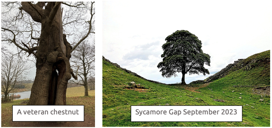
We are one of the most biodiversity depleted countries in the world, and have lost nearly 70% of our biodiversity since the industrial revolution. Trees are vital in supporting biodiversity, with oak trees capable of supporting over 2,300 different species, including birds, mammals, invertebrates, mosses, lichen and fungi.
What is Bristol Tree Forum doing to help?
It is said that the best time to plant a tree is 20 years ago, and the second best time is now.
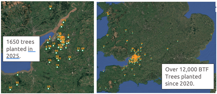
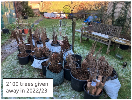
As well as advocating the retention of life-saving trees in our city, Bristol Tree Forum have been encouraging tree planting by holding an annual tree giveaway since 2020. In that year we purchased 1,600 oak saplings from Maelor Forest Nurseries which we distributed free of charge. In 2021/2022 we initially gave away 600 white birch and 400 alder, as well as 900 oak saplings, the latter thanks to a partnership with the Arkbound Oakupy project. We were then contacted by the Forest of Avon Trust who had a surplus of 4,500 tree saplings, over 4,000 of which we were able to distribute through our network of tree planters. Overall, that year we gave away around 6,000 trees including 1,600 oak, 740 silver birch, 860 white birch, 55 grey birch, 600 alder, 100 alder buckthorn, 950 rowan, 45 Scots pine, 60 sweet chestnut, 300 sycamore, 50 spindle and 630 wild cherry. Last year, we manage to distribute 2,102 trees.
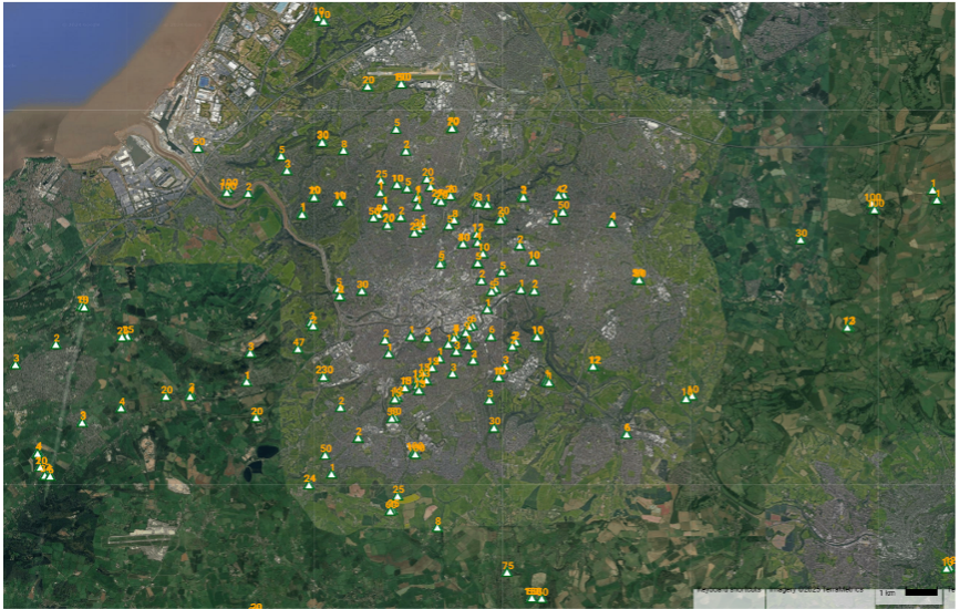
Trees planted in Bristol. Trees were also planted as far afield as West and North Wales, South Devon and Wiltshire.
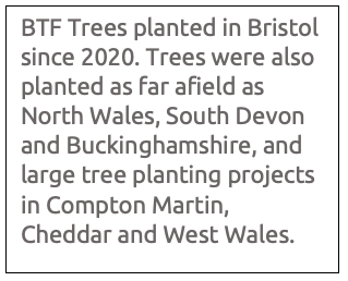
Just some of the trees given away in 2021/22
Flushed with the success of last year’s project, we have ordered another two thousand saplings – pedunculate oak (Quercus Robur) and downy birch (Betula Pubescens) – which we are ready to give away. Each species is a native tree of great benefit to wildlife and is tolerant of urban and rural conditions.
Trees can be ordered using the form below
We will get delivery in late February, when the trees can be collected from a site in Redland, Bristol.
The saplings come bare-rooted (i.e. out of the soil) and need to be planted as soon as possible after collection, although the viability of the trees over winter can be extended by storing the trees with the roots covered in damp soil. The form below is to find out who would like to have saplings for planting and how many, and for you to provide basic contact details (email and/or phone number) for us to organise collection of the trees. Contact details will not be used for any other purpose.
We urge the Bristol City Council Cabinet to reject the current draft. More nuanced rules, that meet identified real needs, need now to be developed following a proper consultation with Bristol’s allotmenteers. The PGSS must be also integrated into the new Local Plan so that all the sites that have been identified are protected either as Local Green Space or as Reserved Open Green Space and given proper planning weight when decisions about their future use and development are made.
We are particularly concerned that the draft rules relating to trees on allotments are too narrowly drawn and will result in the loss of allotment tenants’ ability to make the best use of the particular conditions of their plot. We urge the relaxation of these proposed limits on the number and types of trees which can be planted.
Food growing as part of the draft Parks and Green Spaces Strategy
We are concerned that the Strategy for Food Growing and Allotments has been included as Chapter 6 of the draft Parks and Green Spaces Strategy (PGSS). This is a departure from the 2008 PGSS, which makes it clear that such spaces are not included, since they are not public spaces: ‘The Strategy does not consider green spaces that are not freely accessible to the public, including allotments, city farms, school grounds, or Sites of Nature Conservation Interest in private ownership.’
The proposed PGSS recognises that: ‘There are other green spaces managed by the council that are not included because they do not offer full public access for recreation …’ [our underlining]. Given that allotments and other land used for growing food (including grazing land) are subject to private tenancies, with rental payments and mutual rights and obligations agreed between tenant and Council, it is hard to understand why they have been included in the strategy proposal.
We need to recognise the importance of this specific type of land use and ensure that it is not made an ancillary element in the PGSS. It deserves greater attention, which is why we suggest that it should have been integrated into and protected by the current proposals for the new Local Plan (as, indeed, Parks and Green Spaces should also be) rather than treated as an add-on to the proposed PGSS.
In particular, the current status of and strategy for market gardens, smallholdings and grazing land (and other land not used for food growing), which have an area greater than all current allotments combined, get only passing consideration. Little or no thought is given to the opportunities these sites present for nature recovery, biodiversity enhancement and other environmental gains.
Instead, we are told that these sites:
… have limited benefit beyond the individual users … and many smallholdings tend to use less than 10% of their site for food growing … we now need to review our current landholding agreements so that we can start to explore opportunities to repurpose land to diversify our food growing spaces and ensure land is being used effectively to meet Bristol’s food growing targets. … Once suitable land has been identified we will review how these opportunities are promoted to ensure that the system of securing land is fair and equitable. We are particularly interested in opportunities that will not only ensure land is being sustainably and efficiently managed but that also delivers social value and benefits the residents of Bristol.
In the face of the demand for allotments and the need to increase local food production, which has led at least in part to the proposed changes in the tenancy agreement, these areas must surely warrant greater protection than is given them in the proposed PGSS. These areas also contain many trees (often veterans) and other ecologically sensitive habitats, and many are in SNCIs. It is vital that these matters are properly considered when planning any change of use of such land. This ought to be addressed properly in the proposed new Local Plan, not in this draft strategy.
Trees on allotments
Trees on allotments fall into two categories: those within allotment plots and those on allotment sites but outside the plots.
Trees outside allotment plots
From our analysis of data on the Council’s Open Data site, we estimate that allotment sites total some 105 hectares when community orchards are included. However, only about 87 hectares of these sites are productive. This means that around 17% of allotments, some 18 hectares, are unproductive. We welcome the clarification in the new tenancy agreement that trees in these unproductive areas remain in the care of the Council and may not be damaged by tenants.
Trees within allotment plots
Proposed allotment Rule 4.0 Trees deals with trees growing within allotment plots. We distinguish between newly planted trees and existing trees below.
New trees
Regulation 4.4 limits the height of trees to 2.5 metres (a common constraint in other councils). The limit in Regulation 4.3 of one tree per allotment sized between band B and band C is far too restrictive, particularly since the majority of plots fall within these bands.
Rule 3.1 requires that the tenant uses at least 75% of the plot for ‘a cultivated crop of vegetables, fruit bushes [not fruit trees], ornamental flowers, and herbs.’
Rule 3.3 states that fruit trees will occupy the non-cultivated area of the plot (which may be no more than 25% of the plot) unless they are underplanted with a productive crop, in which case they will be counted as being part of the cultivated area. No trees are permitted on band A or Micro Plots, nor is any consideration given to whether it is possible to underplant ‘a productive crop’. This implies that the food value of the tree does not warrant the space they occupy. According to the RHS, having fruit trees on an allotment adds both structure and permanence, while fruit tree crops have a higher value than many other allotment crops and are easier to manage.
The transitional arrangements require that all trees, except the permitted dwarf rootstock fruit trees, be removed from plots within three years, though mature trees may be permitted.
These rules devalue the role of trees on allotments, not only for their contribution to the ecology of the area but also their food production value. These rules also effectively exclude such fruit-tree-growing techniques as cordons, espaliers or step-over planting.
Regulation 4.3 also constrains the type of fruit trees that may be grown. Since only rootstocks M27 and M26 are allowed (though not the intermediate M9 rootstock), it seems that that only apple trees may be grown, even though dwarfing rootstocks are available for a number of other fruit trees such as Pear, Quince (Quince C), Cherry (Gisela 5), Plum (including Gages and Damsons), Peach and Apricot (VVA-1, Pixy).
The exclusion of hazel and other non-fruit trees (most trees bear fruit) removes the ability of tenants to grow valuable nut crops or to provide locally grown stakes through coppicing – a good way to reduce our carbon footprint. This restriction also precludes the use of allotment space for growing trees from seed with a view to planting them out elsewhere, at a time when there is a great need for locally grown trees for local tree planting.
Established trees
Fruit trees
Many fruit and other trees are already growing on many allotment sites. They provide not only good-value food, but they also provide biodiversity, a rich ecological resource for insects, birds and mammals and are important legacy features of the site. The allotment and its users have adapted to the presence of these trees and their removal would not only be counterproductive to the value of the site and cause distress to tenants but would also risk damaging the soil and the allotment more broadly.
Non-fruit trees
Although such trees may not have obvious value for food production, other considerations apply. We agree that allotments should not be taken over by trees, resulting in the reversion of productive land to woodland and the attendant loss of statuary allotment protection for such land. However, it would be a mistake to create rules which put biodiversity, nature and ecology in conflict with food production; trees are crucial for biodiversity, which in turn is essential for the productivity of the places where we grow food.
Site-appropriate regulations
Allotment plot conditions both within allotment sites and across Bristol vary widely. The gradient and aspect of each plot, its soil type, soil depth and historical development all pose different challenges to tenants, requiring a localised approach to the best way to utilise a site. Imposing a one-size-fits-all set of regulations, based on some notional idealised allotment plot, will not provide sufficient scope to allow for these variations. Tenants’ associations also need to be able to vary the regulations to fit their local conditions. Indeed, arguments in favour of the distribution of local decision making, which we endorse, have recently been made by the Bristol Mayor.
A key factor in calculating the value of a habitat under the new Statutory Biodiversity Metric is to work out its size. In the case of trees, their habitat size can be of critical importance to the calculation of their biodiversity valuation which will, in turn, help to preserve our precious tree habitats.
As a result, individual trees in an urban setting are often the most important habitat present.
Unfortunately, developers may be tempted to allocate all trees on their planned development site (especially those in groups) to Woodland and forest habitats rather than to Individual trees habitat, because this gives the trees and the site a lower biodiversity value. An example of this is the proposed development by Goram Homes of Hengrove Park in Bristol, as shown in the image above and discussed below. The whole site was granted outline planning permission in October 2019.
Unfortunately, the Statutory Biodiversity Metric User Guide (the Metric) definitions of these habitats are ambiguous and can make such allocations hard to counter, even in settings that are clearly urban.
The User Guide defines two broad tree habitats types whose areas are measured in hectares (ha):
Woodland and forest
Individual trees
Defining woodland and forest habitat
There are conflicting definitions of ‘woodland’. The Metric User Guide does not define Woodland and forest habitat.
However, the UK Habitat Classification, UKHab, upon which the Metric is based, defines it as ‘Land with 25% or more cover of trees that are five metres or more in height.’ This definition doesn’t mention the minimum land area required.
‘a minimum area of 0.5 hectares under stands of trees with, or with the potential to achieve, tree crown cover of more than 20% of the ground. Areas of young trees, which have the potential to achieve a canopy cover of more than 20%, will also be interpreted as woodland and mapped. The minimum width for woodland is 20 m, although where woodlands are connected by a narrow neck of woodland less than 20 m wide, the break may be disregarded if less than 20 m in extent.‘
Bristol City Council also uses area to define woodland in its 2008 Biodiversity Action Plan (Chapter 5, page 65), which states that ‘this action plan covers all woodlands over 0.5 hectares in extent found in Bristol.‘ As this is a local policy, and aligned with the NFI definition, we have adopted it.
The habitat area of Woodland and forest habitats is based on its total measured canopy area.
Defining individual trees habitat
The Metric User Guide (page 53) advises when to record Individual trees habitat:
Individual trees are classed as ‘urban’ or ‘rural’. You should consider the degree of ‘urbanisation’ of habitats around the tree and assign the best fit for the location.
Use the broad habitat type ‘Individual trees’ to record:
individual rural trees
individual urban trees
lines, blocks or groups of trees found within and around the perimeter of urban land.
In all circumstances ‘Individual trees’ should be used to record ancient and veteran trees, regardless of location. This could include ancient and veteran trees within hedgerows, ‘rural’ lines of trees and woodlands.
Other clarifications
Do not use the hedgerow module classifications ‘line of trees’ and ‘ecologically valuable line of trees’ to record linear formations of trees in the urban environment.
These classifications should only be used for rural lines of trees. Trees within overgrown non-native and ornamental hedges (for example, leylandii) should not be classified as individual trees, or as lines of trees. Record these as nonnative ornamental hedges within the hedgerow module.
Trees recorded as individual trees that will be removed for any purpose, including development, disease, or safety must be recorded in your baseline and recorded as lost.
Do not otherwise record individual trees if they occur within a habitat type characterised by the presence of trees, unless specified within the section on ‘recording individual trees at baseline’, which covers:
trees within private gardens
removal of trees within hedgerows
removal of trees within rural lines of trees
removal of trees within orchards and wood-pasture and parkland
Recording individual trees at baseline
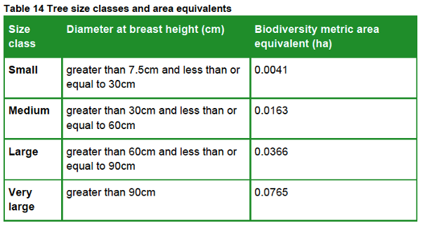
The biodiversity metric uses set values to represent the area of individual trees depending on their diameter at breast height.
This value is a representation of canopy biomass, and is based on the root protection area formula, derived from BS 5837:2012.
Table 14 sets out class sizes of trees and their area equivalent.
The User Guide then deals with specific instances where individual tree habitats also need to be recorded:
Recording baseline trees within private gardens
A private garden is a garden within the curtilage of a privately owned or tenanted dwelling house. Private gardens can contain important features for biodiversity, including mature trees and hedgerows.
record all medium, large and very large trees within private gardens as individual trees
Recording baseline trees within hedgerows and lines of trees
if any medium, large or very large trees within a hedgerow or ‘rural’ line of trees are being removed, record these in the area baseline as individual trees
the removal of trees may influence the linear value of hedgerows and ‘rural’ lines of trees within the hedgerow module
Recording baseline trees within orchards and wood-pasture and parkland
if any medium, large and very large trees within these habitats are being removed, record these in the area baseline as individual trees
this does not change the way in which you would record the area of orchard or wood-pasture and parkland area habitat (see ‘Recording habitat mosaics’ section)
Calculating the number of post-development trees required
Post-development size classes
When planting trees post-development size class is determined by the size of the tree at site-planting. When using the tree helper:
record newly planted individual trees as ‘small’, unless ‘medium’ size or above at the time of site-planting
record trees planted with a DBH less than 7.5 cm as ‘small’
You should not:
record natural size increases of retained trees within post-development sheets
record natural size increases of planted trees within post-development sheets
The post-development private garden has no public access, and biodiversity net gains cannot be legally secured. As these gains cannot be secured you should only record created private gardens as either:
‘urban – vegetated garden’; or
‘urban – unvegetated garden’
You should not:
record the creation of any other new habitats within private gardens
record enhancement of any habitat within private gardens
However, habitats which are recorded in the baseline and remain within a private garden may be recorded as retained.
A garden within the curtilage of a privately owned or tenanted dwelling house. The post-development private garden has no public access, and biodiversity net gains cannot be legally secured.
How these rules affect the tree habitat area calculation
As a result, this approach places a higher value on the areas of all but the largest Individual trees habitats than those that form part of a Woodland and forest habitat. The following graph shows this, with RPA, derived from DBH, representing the canopy biomass of both broad habitats.
We analysed 12 recent planning applications involving 2,116 trees, 612 (29%) of which were identified for removal. Using the Metric User Guide, they have a combined habitat area of 20.2 ha. If they are measured by canopy area it would only be 8.3 ha (41% of their habitat size). If their combined Root Protection Areas (RPA) were used, they would cover only 8.6 ha (43% of their habitat size).
On the basis that all these trees are in poor condition and have no strategic significance, we calculate that, with the minimum 10% biodiversity net gain now required, a total of 1,925 new trees would need to be planted to replace the habitat lost by the removal of these 612 tree – a ratio of just over 3:1.
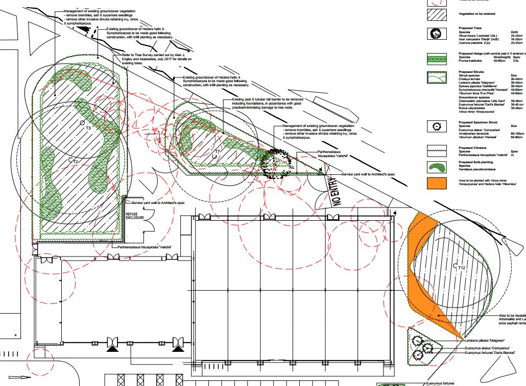
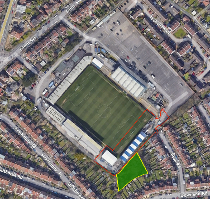
To illustrate how this can affect actual applications, here’s a pending application by Goram Homes at Hengrove Park in Bristol. The area edged in red is the development site.
This next image shows how the applicant’s ecologists have defined each habitat: the woodland and forest habitats are shown as a diamond pattern on a dark green background. They cover 2.44 ha.
They’ve also identified 0.19 ha of Individual trees habitat, that is, trees not growing within the woodland and forest habitats.
Area 8 in the south of the site (0.99 ha) might legitimately be designated Woodland and forest habitat, but, given that all the remaining trees are growing separately and in groups in an urban park, they should be designated UrbanIndividual tree habitat.
The site is complex, with many trees growing in groups but, by excluding the trees in area 8 and treating all the other onsite trees as UrbanIndividual tree habitat, we calculate that their habitat area is 6.42 ha. This is 4.78 ha more than the applicant’s calculation. This difference will clearly have a significant impact on the final biodiversity net gain calculation, valuing these habitats at 34.07 area habitat units (or 2,989 Small size trees) as opposed to the applicant’s 12.11 (or 1,063 Small size trees).
To give the applicant their due, they at least attempted to calculate the tree habitat area. We have seen other applications where the trees were simply ignored, or were classified as another habitat – bramble scrub in one case, or the method by which the Individual trees habitat area was calculated bore no relationship to the evidence submitted. We must remain ever vigilant against such tricks.
This blog was amended on 09 May 2024 to include the comments of the Nature Conservation Officer dated 03 May 2024 about whether the trees on the Hengrove Park development site are Individual trees habitat or Woodland and forest habitat. The officer writes:
This blog was amended on 14 February 2024 following the obligation for most planning applications to achieve at least 10% biodiversity gain becoming obligatory on 12 February 2024.
Further changes have been made following updates published in July and August 2024, in particular the clarification of the application of BNG in private gardens.
We believe the time has come to revise the Bristol Tree Replacement Standard (BTRS), to reflect our changing understanding of the vital importance of urban trees to Bristol and how they contribute to biodiversity gain.
The current BTRS Standard, adopted nearly a decade ago in July 2014, provides a mechanism for calculating the number of replacements needed for any trees that are removed for developments. It was ground-breaking in its time as it, typically, required more than 1:1 replacement of trees lost to development.
Since then, Defra has published the statutory version of the Biodiversity Metric (SM) (on 29 November 2023), which became mandatory on 12 February 2024. In addition, Bristol has adopted Climate and Ecological Emergency Declarations, so an updated BTRS would be an important part of implementing these declarations. It would require all new developments, subject to some exceptions, to achieve a Biodiversity Net Gain (BNG) of at least 10%. Where developments are exempt, BTRS will still apply.
Although Councillors rejected our proposals for a new Standard at their meeting on 31 October last, we’ve revisited our July 2023 proposals and recast our calculations. These proposals, set out below, provide a mechanism for complying with the new requirements and align the BTRS with the BNG provisions of the EA 2021.
The purpose of the BTRS is that it should only ever be a last resort and not the default choice – which, unfortunately, it has become. When considering any development involving established trees, the presumption should always be that trees will be retained. If this is not possible, then the impact of the proposed development must be mitigated. Only if this is impossible, should compensation for their loss be considered. This is the meaning of the Mitigation Hierarchy, as set out in paragraph 180 a) of the National Planning Policy Framework, which states:
If significant harm to biodiversity resulting from a development cannot be avoided (through locating on an alternative site with less harmful impacts), adequately mitigated, or, as a last resort, compensated for, then planning permission should be refused.
This is reflected in the Bristol Core Strategy, policy BCS9(page 29),which states that:
Individual green assets should be retained wherever possible and integrated into new developments.
This is repeated in the proposed replacement for BCS9 – Policy BG1: Green infrastructure and biodiversity in new development(page 124) – which ‘aims to ensure that green and blue infrastructure and provision for nature is incorporated into new development’ so that, among other things:
The provision of green infrastructure in new development should … Retain and incorporate important existing green infrastructure such as trees (Policy BG4 ‘Trees’), hedgerows and water features …
It is a shame that the requirement is only an aspiration, not an obligation.
Background
Under the new proposed policy – BG4: Trees (page 131) – trees lost to development will be replaced using this table:
Table 1 The proposed BG4 tree replacement table.
However, when the balance of EA 2021 takes effect, the current version of the BTRS will not, in most cases, be enough to achieve the 10% BNG minimum required for nearly all developments. A new Section 90A and Schedule 7A will be added to the Town and Country Planning Act 1990 and will set out the level of BNG required.
Under the statutory framework for biodiversity net gain, subject to some exceptions, every grant of planning permission is deemed to have been granted subject to the condition that the biodiversity gain objective is met (“the biodiversity gain condition”). This objective is for development to deliver at least a 10% increase in biodiversity value relative to the pre-development biodiversity value of the onsite habitat. …
Many development proposals will aim to achieve more than the minimum 10% gain voluntarily. Others may not but will still need to achieve much more in order to comply with the SM trading rules (page 140). This is based on the habitat type lost and its distinctiveness. In the case of Individual tree habitats – Urban or Rural – losses must be replaced within the same broad habitat (i.e. more Individual trees) or with a habitat of a higher distinctiveness.
However, for the sake of certainty, we propose only using the minimum 10% BNG required.
Our proposed new BG4 (BTRS) model
We propose that the table in BG4 be amended to reflect the requirements of the EA 2021 and SM and that the BG4 table (Table 1 above) be replaced with Table 2 below:
Table 2 Our proposed BG4 tree replacement requirement
The Replacement Trees Required number is based on the habitat area of each of the four SM tree category sizes (Table 13 below), divided by the area habitat of one BNG 4.0 Small category tree (see section 3 below) plus a 10% net gain. This is rounded up to the nearest whole number (since you can’t plant a fraction of a tree).
The reasoning for our proposal is set out below:
1. Applying the Biodiversity Metric to Urban trees
Use the broad habitat type ‘Individual trees’ to record trees where:
they are found as an individual or as part of a group;
are over 7.5cm in diameter at breast height (DBH).
Individual trees should also be recorded where they meet the definition of an irreplaceable habitat but would not otherwise be recorded.
Do not otherwise record individual trees if they occur within an area habitat type characterised by the presence of trees, examples of these are:
woodlands
orchards
wood-pasture and parkland
Individual trees are classed as ‘urban’ or ‘rural’. You should consider the degree of ‘urbanisation’ of habitats around the tree and assign the best fit for the location.
2. Calculating Individual trees habitat
Table 13 in the SM User Guide is used to calculate the ‘area equivalent’ of individual trees:
The biodiversity metric uses set values to represent the area of trees depending on their diameter at breast height. This value is a representation of canopy biomass, and is based on the root protection area formula, derived from BS 5837:2012.
You should report the number of individual trees within your project and input tree count into the ‘tree helper’ within the biodiversity metric tool to generate area values for data input. For multi-stemmed trees, use the DBH of the largest stem. You should:
account for each individual tree within a group or block of trees.
record the habitat underneath the tree canopy separately.
not reduce any area generated by the tree helper.
not deduct the area of individual trees from other habitats.
make clear in the user comments how many trees contribute towards the total area.
Recording trees within private gardens
You should assess most individual trees that are recorded in private gardens. You should record:
any medium, large and very large trees as individual trees
any small trees that are ancient or veteran
Recording trees within hedgerows
You should assess most individual trees that are recorded within hedgerows. You should record:
any medium, large and very large trees as individual trees
any small trees unless they are ancient or veteran.
You must assess the linear value of hedgerows within the hedgerow module separately.
Individual Tree habitats have medium distinctiveness and so, under Rule 1 of SBNG, ‘Losses must be replaced by area habitat units of either medium band habitats within the same broad habitat type or, any habitat from a higher band from any broad habitat type.’
3. Forecasting the post-development area of Individual trees
The SBNG User Guide provides this guidance:
You should use the tree helper to calculate the area for created trees.
You should categorise most newly planted individual trees as ‘small’, unless the tree is medium sized or above at the time of planting.
You should not factor in the age of nursery stock when using the ‘creation in advance’ function. The ‘creation in advance’ function should only be used where trees are planted in advance of the development (for example, as screening or as structural landscaping).
Exceptions
You cannot count:
newly planted trees within private gardens
natural size increases of baseline trees
trees planted as part of hedgerow creation or enhancement as individual trees.
Our calculations are based on Small category replacement trees being planted as per the SM guidance.
4. The likely impact of this policy change
We have analysed tree data for 1,038 surveyed trees taken from a sample of BS:5837 2012 tree surveys submitted in support of previous planning applications. Most of the trees in this sample, 60.5%, fall within the SM Small tree category, 32.9% are within the Medium tree category, 5.4% are in the Large tree category with the balance, 1.3%, being categorised as Very Large.
Table 4 below sets out the likely impact of the proposed changes to BG4. It assumes that all these trees were removed (though that was not the case for all the planning applications we sampled) and replaced with SM Small category trees:
When the Development Control Committee last met to discuss the Council’s application to extend the cemetery at South Bristol into the SNCI at Yew Tree Farm on 6 September 2023, we were disturbed to hear the Chief Planner’s interpretation of the meaning of ‘harmful impact’, as set out in the Local Plan policy, DM19 – ‘Development which would have a harmful impact on the nature conservation value of a Site of Nature Conservation Interest will not be permitted.’
As we received no reply at the time, we took the opportunity to ask again when the Committee reconvened to make its decision on 29 November 2023. We asked two questions – see page 9 of the Public Forum. As the responses still didn’t really satisfy, we asked two supplementary questions:
When you say, ‘the site’, what do you mean? Is it within the redline boundary or something else such as within the SNCI’s boundary?
You say ‘The crucial additional clarification to highlight, is that to be in alignment with this policy it is NOT the overall biodiversity gain that is determinative. There rather needs to be an assessment that establishes whether there is harm with reference to the specific characteristics that make the site special.’
Does this mean that the replacement of one habitat which forms part of the ‘specific characteristics that make the site special’ – such as a replacing the Grassland Habitat that forms part of the current SNCI designation with a Lake Habitat that does not form part of the current SNCI designation, or that the provision of offsite mitigation measures to compensate for onsite habitat losses (in this case -6.44%) – would not be acceptable?
These were the replies:
To question 1
By ‘the site’, it’s the site as set out in the application document, so it’s the SNCI as contained in the application document the area in the redline boundary.
To question 2 (as it is quite complex, we have reproduced it verbatim)
You need to take the application as a whole and where it is demonstrated as that with regard to the features, particularly the grassland, that there is no impact ultimately or, if anything, a slight enhanced impact.
We intervened to ask – So you are saying that the substitution of the grassland habitat for a lake habitat…?
I am not saying that at all, I am saying that the grassland, actually that there is more grassland and that’s what the ecology report also says – more grassland of the type for which the SNCI is designated will be there through this application than before… within the redline boundary.
Anyone who wants to develop land must produce a location plan of the area proposed for development, delineated by a red line – the so-called ‘redline boundary’.[1]
When planning permission is granted, only the area within the redline boundary may be developed (though ancillary works may take place elsewhere).
Here is the location plan for the South Bristol Cemetery Extension application:
The South Bristol Cemetery Extension location plan (North is at the top)
The redline boundary here is quite complex because it’s made up of two burial areas, in the north and south, and an attenuation pond to collect runoff from the northern burial ground through a series of drains (the southern burial ground runoff will drain straight into Colliter’s Brook to the west). The area within the blue line is also owned by the Council and so is under their control.
The redline boundary is also important when it comes to calculating the biodiversity value (BNG) of the development site. All the habitats within the redline boundary are treated as ‘onsite’, while those outside the boundary are treated as ‘offsite’.
So, when we are told that ‘… there is more grassland and that’s what the ecology report also says – more grassland of the type for which the SNCI is designated will be there through this application than before… within the redline boundary,’ it’s just the onsite area that’s being referred to. This is important, as we show below.
The headline results shown in the most recent BNG 3.1 calculation relied on by the Council[2] show that 6.44% of the baseline onsite area biodiversity will be lost as a result of the development (see Figure 1).
Figure 1: The BNG 3.1 Headline BNG results.
Figure 2 shows the net losses of the onsite grassland habitat:
Figure 2: Grassland Area & Habitat Unit analysis (HUs)
Under the BNG Trading Rules, Medium Distinctiveness grassland habitats may only be replaced with the other Medium Distinctiveness grassland habitats or with habitats of a Higher Distinctiveness. So, in order to achieve the net 2.93% BNG which the Council claims will result from the development, it will be necessary to compensate for these losses by crediting 3.25 Habitat Units of High Distinctiveness Lakes habitat by creating the attenuation pond.
This is not what we are told is happening and it certainly cannot be said that: ‘… there is more grassland … of the type for which the SNCI is designated … within the redline boundary,’ This is plainly untrue and, even on the Chief Planner’s definition (which we do not accept), it is clear that this application will ‘have a harmful impact on the nature conservation value of a Site of Nature Conservation Interest.’ This is contrary to DM19.
What’s more, even if the proposed offsite habitat mitigations were taken into account, there’d still be a net loss of -0.47 HU of Medium Distinctiveness grassland habitat (see Figure 4 below).
Figure 4: Net Medium Distinctiveness habitat losses
There’s one other serious flaw in the application, which was not brought to the attention of the Development Control Committee at its meeting. There’s a shortfall of -0.11 Habitat Units of the High Distinctiveness habitat, Species-rich native hedgerow with trees. Lost High Distinctiveness habitats may only be replaced like-for-like. This has not happened. As a result, the application is in breach of the BNG Trading Rules and should not have been approved.
We have brought this to the attention of the Council and the LPA.
These are just some of the important reasons why we say that the Development Control Committee was wrong to grant this flawed application.
The Mayor has now published the next iteration of the proposed new Local Plan (LP). This will be brought before you at Full Council on 31 October next. The Mayor recommends (item 8) that, under Regulation 19 of the Town and Country Planning (Local Planning) (England) Regulations 2012, the draft LP will be formally published in order for representations to be made and then submitted to the Secretary of State for examination.
The sustainability appraisal documents are published on the Local Plan Review web page.
In our opinion the proposed LP is not yet ready for further consultation, let alone independent examination, for the following reasons:
It does not contain enough detailed information about the sites in the adopted LP to allow for a proper consultation or independent examination.
Protection for green spaces has been reduced, contrary to adopted Council policy.
Despite the recent Ecological and Climate Emergency Declarations, this draft provides fewer environmental protections than the adopted LP.
Comments on earlier drafts appear largely to have been ignored, rendering the consultation process flawed.
Our response in detail
Section 20 (2) of the Planning and Compulsory Purchase Act 2004 states that the authority must not submit the proposed LP unless they think the document is ready for independent examination. In our view, the proposed LP is not yet ready for further consultation, let alone independent examination. Our reasons are set out in detail below:
A proper consultation has not been conducted. In a 2001 judgement Lord Woolf defined a proper consultation as containing four elements.[1] The final element is that ‘the product of consultation must be conscientiously taken into account when the ultimate decision is taken’. You have not responded to our carefully considered comments on both the 2019 and the 2022 consultations on earlier drafts of the LP and there is no evidence that the Local Plan Working Party even discussed them. We do not know how many other organisations who submitted comments were also ignored, because these have not been published.
When the 2019 document, New Protection for Open Space, was published for consultation, a schedule with maps was produced so that consultees could see which sites were being proposed and with what designation – Local Green Space (LGS) or Reserved Open Space (ROS). No such document has been produced in this version, which means that there is no easy way for consultees to see what has been changed, added or removed – save for slavishly working though the only document showing the new designations set out in 08.3 Appendix A3 Policies Map. Whilst this may be sufficient for those interested only in the information at ward level, it is nigh on impossible for those with a city-wide interest.
An interactive GIS map of the proposed Bristol Local Plan Policies Map should be made available to facilitate examination. The pdf version provided has 38 layers in the Key and many sites have multiple designations, which makes it very difficult to interpret. The current Local Plan Policies map does this.
Whilst the document Appendix 3 Assessing the effects of the Publication Version Policies, cross-references, to a limited extent, how some proposed new policies relate to policies in the adopted LP, there is no equivalent schedule for the adopted policies which will be removed – Core, Site Allocation and Development Management Policies (SADMP) and ancillary Supplementary Planning Documents (SPDs) etc. – nor any comprehensive cross-tabulation showing which of the adopted LP policies have been transferred to the proposed LP and which have not.
No schedule has been prepared showing those sites protected under the adopted LP and whether they will be protected under the proposed LP. For example, SADMP DM17 currently provides protection for sites designated as Important Open Spaces, Unidentified Open Spaces and Urban landscapes. It appears that DM17 will be removed but that these current protections will not be adopted in the proposed LP. We have mapped 523 Important Open Space sites covering over 2,000 hectares. As far as we can see, some 1,000 hectares of these and all Unidentified Open Spaces and Urban landscapes, will no longer have any protection. If this is the case, then the proposals should make this clear. Our recent article, Will Councillors Honour Their Promise To Protect Bristol’s Green Spaces? addresses our wider concerns.
SNCIs are currently given protection from development under SADMP DM19. This states that ‘Development which would have a harmful impact on the nature conservation value of a Site of Nature Conservation Interest will not be permitted’. It is proposed that DM19 will be removed in its entirety. Under proposed new policy BG2: Nature conservation and recovery, this protection has been changed to read: ‘Development which would have a significantly harmful impact on local wildlife and geological sites, comprising Sites of Nature Conservation Interest (SNCIs) and Regionally Important Geological Sites (RIGS) as shown on the Policies Map, will not be permitted.’ This is a dilution of the current protection enjoyed by SNCIs (and RIGS); the phrase ‘significantly harmful’ is a subjective judgement and undermines the current protection provided, especially when the Chief Planning Officer has recently advised Councillors that damage to an SNCI which is offset by onsite mitigations under the Biodiversity Metric is not harm.
Whilst we are very pleased to see that our campaign to have all those Sites of Nature Conservation Interest (SNCIs) which were allocated for development in 2014 (save for BSA1305 – why?) has succeeded and have had their Site Allocations removed, we are concerned to note that not all of the 108 sites (not 85 as is wrongly suggested) have also been designated as LGS – some are ROS and some have no designation at all. No explanation has been given for this.
No schedule of the sites identified in BG2 has been produced. As we have pointed out, there are 108 SNCIs, not the 85 stated in Appendix 1: Sustainability Appraisal Updated Scoping Report 2023 A1-4 (at page 26). A schedule of all these sites will enable consultees to identify and locate them.
In September 2021 the council unanimously resolved to protect the Green Belt and Bristol’s green spaces. Despite this, around 30 of the 96 sites proposed for residential development are green spaces (nearly 40 hectares) and three areas in our urban Green Belt are proposed to be removed from the Green Belt for development. No new green or open spaces are proposed.
Proposed policy BG4: Trees is deeply flawed. As currently drafted it will allow developers to offset tree losses by using habitats that are not allowed under BNG 4.0. If allowed this will result in the hollowing out of Bristol’s trees and frustrate the One City plan to increase tree canopy (see Annex A below).
The proposal that replacement trees ‘should be located as close as possible to the development site’ will still allow developers remove trees to build, because all they need to do is pay compensation for their replacement with no concern for where they are to be planted. This will result in trees and their biodiversity being lost from those areas under greatest development pressure, with any offsite compensation being exported to already green suburbs and creating even greater tree inequalities.
It is proposed that development which would result in the loss of ancient woodland, or ancient or veteran trees, will not be permitted, but neither Bristol’s known veteran trees nor its 11 ancient woodlands are mapped or expressly protected on the Bristol Local Plan Policies Map.
No express protection is given for other urban woodlands that are not ancient (woods that have not existed continuously since 1600), are not in a conservation area or are not protected with a TPO.
Our request
Bristol City Council has recently declared both Climate and Ecological Emergencies and resolved to protect our green spaces. The Environment Act 2021 with its still-to-be-published regulations (which will be fully implemented in 2024 together with a proposed new version of the National Planning Policy Framework) will provide even greater environmental protections and the next iteration of the One City Plan aspires to achieve a significant increase of tree canopy. Yet, against all this, the proposed new Local Plan will result in reduced protection for the environment when compared with the current, adopted Local Plan.
In light of this, we ask you to reject the Mayor’s recommendation until the above crucial issues have been addressed and insist that Bristol’s nature does not continue to suffer yet more decades of decline but is properly protected.
The Bristol Tree Forum
24 October 2023
Annex A – Email to BCC Specialist Planning Policy Officer 21 October 2023
Dear Michael,
I see that the latest iteration of the proposed Local Plan has been published. We are examining it and will comment in due course, but we have to express serious concerns about the proposed new wording of Policy BG4: Trees.
We are disappointed that our proposal for BTRS has not been adopted, but we are also very concerned that this paragraph in particular, will provide developers with an opportunity to avoid replacing lost trees at all: ‘Where the tree compensation standard is not already met in full by biodiversity net gain requirements (policy BG3 ‘Achieving biodiversity gains’), for instance because biodiversity net gain requirements do not apply to the development or because biodiversity gains are provided through a different habitat type, development will still be expected to meet the tree compensation standard on-site or off-site through an appropriate legal agreement.‘
As you know, most trees in an urban environment will be classified as broad Individual tree habitat under BNG 4.0. This broad habitat has only two sub-types – rural and urban – and can only be replaced with the same broad habitat type (Individual tree) or by a more distinctive, High or Very High habitat. This means that other Medium (e.g. most woodland habitats) or Low distinctiveness habitats cannot be used without breaking the BNG 4.0 trading rules – as BG4 currently suggests it can. These High or Very High distinctiveness habitat types are rare, especially in the urban space.
In this case, developers (who will not have the space to create all the Individual tree habitat that BNG 4.0 will demand**) will offer these or Individual tree habitats elsewhere and, because there are no such sites in Bristol, will offset the BNG losses out of the city, resulting in the hollowing out of Bristol’s trees and frustrating the One City plan to increase tree canopy.
We suggest that the proposed wording could also make BG4 unworkable because it is contrary to the BNG 4.0 rules and guidance. We suggest that you delete the words ‘or because biodiversity gains are provided through a different habitat type.’
Can you clarify whether the current Bristol Tree Replacement Standard SPD will remain, please. Is there a list of proposed deprecated policies and SPDs etc. available?
** For example, one small single dwelling development we are looking at which would require five BTRS trees to be planted to replace the three lost, will require 148 BNG 4.0 Small category trees to be planted to achieve a net gain of just 10%. There is not enough room on the site to plant the five BTRS trees, let alone 148.
Subsequent email to BCC Local Plan Team Manager 26 October 2023
Dear Colin,
I am sure you have seen our request to councillors in advance of next week’s Extraordinary Full Council meeting to adopt the Mayor’s recommendation to allow the draft Local Plan to progress to Regulation 19/20 consultation and then to independent examination. If not, I attach a copy.
We Bristolians are as much entitled to know which of their places (and a Local Plan is surely all about place) will not be protected under a new Local Plan as they are to know which will be. Yet, as far as we can see, this information has not been published with the papers laid before Councillors. Please correct me if I am wrong.
For example, we are aware that, under the 2019 document, New Protection for Open Space, it was proposed that Important Open Spaces, currently protected under SADMP DM17, would be replaced with new policies for Local Green Space (LGS) and Reserved Open Space (ROS) (para 2.13). It was obvious then that this would result in a large number of sites, currently protected under this part of DM17, losing this protection because they were not going to be designated as either LGS or ROS nor given any other protections. You will recall that it took us quite some time to get a list of these deprecated sites which we then listed in Appendix A of our response to that consultation. We have no idea whether our representations were considered. From what we have seen, it appears that, if they were, then they were ignored.
It also appears that those other places also given protection under DM17 – Unidentified Open Spacesand Urban landscapes – will also no longer be protected under the new plan, though this has not been expressly stated as far as we can see. It may well be that other place protections have also been quietly dropped and not replaced, but we cannot tell. This is why we are calling for the following schedules (preferably geolocated) to be published before the next stage of the consultation begins:
All proposed LGS/ROS designations.
All sites (places) currently protected under the adopted Local Plan and how they will be protected (or not) under the new LP.
Currently adopted policies which will be removed – Core, Site Allocation and Development Management Policies (SADMP) and ancillarySupplementary Planning Documents (SPDs) etc. – cross-tabulated to show which of these policies have been transferred to the proposed LP and which have not.
All sites proposed to be protected under BG2.
All known veteran and ancient trees and woodland within the city boundaries.
If this information is not provided then it will be impossible for those who wish to respond to the consultation to make an informed decision whether or not to accept what is being proposed and the whole consultation process will, we suggest, be fatally flawed.
I have also heard it suggested that, should Councillors not approve the Mayor’s recommendation then the current adopted Local Plan will lapse and allow developers to proceed as they wish. You know as well as I do that this is not correct. It may well be that, on appeal, developers may argue that Paragraph 11d of the NPPF applies because the Local Plan is out-of-date (Homes England argued this in the recent Brislington Meadows appeal), but this is a very different matter from what I understand has been suggested. Hopefully you will ensure that Councillors are not misled if this is repeated.
I look forward to hearing from you.
[1] R v North & East Devon Health Authority, ex parte Coughlan [2001] QB 213, [2000] 3 All ER 850, 97 LGR 703
We were very disturbed to hear your advice to Councillor Pearce at last night’s Development Control Committee B meeting to consider the expansion of South Bristol Cemetery on to land used by Yew Tree Farm, a Site of Nature Conservation Interest (SNCI). You advised Councillor Pearce that the definition of ‘harm’ under SADMP DM19 was based on the net (not gross) harm caused after mitigation had been considered.
You seemed to be using Biodiversity Net Gain (BNG) as the proxy for harm, so that the reported net gain of nearly 3% was sufficient to conclude that there was no ‘harmful impact’ as defined by DM19.
Bristol Local Planning Policy DM19 plainly states that ‘Development which would have a harmful impact on the nature conservation value of a Site of Nature Conservation Interest will not be permitted.’ It could not be clearer.
If your interpretation of this is correct (and we say it cannot be), it will effectively nullify any policy protection for SNCIs or indeed, any other existing green infrastructure and all SNCIs could be developed in a free-for-all. We set out our reasoning below.
The Mitigation Hierarchy
The Mitigation Hierarchy, as enshrined at paragraph 180 a) of the NPPF, states:
When determining planning applications, local planning authorities should apply the following principles:
a) if significant harm to biodiversity resulting from a development cannot be avoided (through locating on an alternative site with less harmful impacts), adequately mitigated, or, as a last resort, compensated for, then planning permission should be refused;
On your interpretation, the first element of this cascading test, avoidance, will never have to be applied. Instead, you need only consider the second element, mitigation, for it is only then that ‘harm’ can be assessed. This cannot be the intention of this provision.
Green spaces protection
The effect of your approach is to make a nonsense of the prohibition against causing any ‘harmful impact’ to an SNCI as conferred by DM19. It effectively nullifies the special protection given to these sites. Here is the full DM19 policy wording:
On your interpretation, the whole section relating to Sites of Nature Conservation Interest may as well be deleted, as it adds nothing to the more general policy set out above.
The section relating to wildlife corridors is also rendered meaningless if there can now be no net ‘harmful impact’.
The same conclusion must also apply to the protection of Urban Landscapes under SADMP DM17, another feature which ‘contributes to nature conservation in Bristol’, on your interpretation. Your interpretation might also be extended to the other Existing Green Infrastructure identified in DM17.
Achieving BNG means there is no ‘harm’
When the Environment Act 2021’s requirement for all developments to achieve at least 10% biodiversity net gain takes effect later this year, it must follow that schemes which achieve this will have caused no ‘harm’ under your definition.
How then should this be interpreted if the net gain can only be achieved through offsite mitigation (as will often be the case)? Even in this scenario, it seems that there can never be any circumstance where an SNCI can suffer a harmful impact because it must always be mitigated by the requirement to achieve at least 10% BNG. It is even possible to imagine that the SNCI status of the target site will be lost as a result of the development, yet, as you see it, this will not be ‘harm’.
You are in effect stating that no SNCI in Bristol now has any greater protection than any ‘other habitat, species or features, which contribute to nature conservation in Bristol’ and the whole special status of SNCIs has become meaningless.
This cannot be what was intended when SNCIs were created and given special protection under the Local Plan.
We urge you to reconsider your advice.
Our statement to the Planning Committee can be read here.
Following discussions with the Council about our recent proposal to revise BTRS, we have drafted a new version which we believe will strengthen tree protection across the city even further if it is adopted into the proposed new Local Plan.
Revisions are shown in red.
The latest version of the Biodiversity Metric (BNG 4.0), just published by Natural England,[1] is likely to become mandatory when the balance of the Environment Act 2021 comes into force later this year. We have revisited our June 2022 proposals and reviewed our calculations. We have met with Bristol City Council Officers and discussed possible alternatives with them. Here is the revised version.
The Bristol Tree Replacement Standard[2] (BTRS), adopted a decade ago, provides a mechanism for calculating the number of replacements for any trees that are removed for developments. It was ground-breaking in its time as it, typically, required more than 1:1 replacement of trees lost to development and within one mile of the development.
The presumption when considering any development involving established trees should always be that trees will be retained. The application of BTRS should only ever be a last resort. Providing funds in exchange for trees that are removed on development sites should not be the default choice which it seems to have become. In addition, in many instances, the locations of the promised replacement trees are not specified and the trees are never planted. As a result, section 106 tree replacement funds continue to accumulate to the 2023 figure of approximately £800K. This figure as barely changed over the years we have been monitoring it.
The starting point for any decision on whether to remove trees (or any other green asset for that matter) is the Mitigation Hierarchy. Paragraph 180 a) of the National Planning Policy Framework sets it out as follows:
If significant harm to biodiversity resulting from a development cannot be avoided (through locating on an alternative site with less harmful impacts), adequately mitigated, or, as a last resort, compensated for, then planning permission should be refused.[3]
BTRS is and should always be ‘a last resort’. This is reflected in the Bristol Core Strategy, policy BCS9 adopts this approach and states that:
Individual green assets should be retained wherever possible and integrated into new developments.[4]
However, with the development of a new Local Plan for Bristol, we believe that the time has come for BTRS to be revised to reflect our changing understanding of the vital importance of urban trees to Bristol in the years since the final part (SADMP[5]) of the Local Plan was adopted in 2014.
In addition, Bristol has adopted Climate and Ecological Emergency Declarations so a new BTRS will be an important part of implementing these declarations. Nationally, the Environment Act 2021[6] (EA 2021) will come force later this year. This will require nearly all developments to achieve a Biodiversity Net Gain (BNG) of at least 10%. Our proposal provides a mechanism for complying with this new requirement and so aligns BTRS with the BNG provisions of the EA 2021.
Background
Under current policy – BCS9 and DM17[7] – trees lost to development must be replaced using this table:
Table 1 The Current DM17/BTRS replacement tree table.
However, when the balance of EA 2021 takes effect, the current version of BTRS will not, in most cases, be sufficient to achieve the 10% BNG minimum that will be required for nearly all developments. A new section 90A will be added to the Town and Country Planning Act 1990 and set out the level of BNG required (see Schedule 14 of EA 2021[8]).
The Local Government Association says of BNG that it:
…delivers measurable improvements for biodiversity by creating or enhancing habitats in association with development. Biodiversity net gain can be achieved on-site, off-site or through a combination of on-site and off-site measures.[9] GOV.UK says of the Biodiversity Metric that: where a development has an impact on biodiversity, it will ensure that the development is delivered in a way which helps to restore any biodiversity loss and seeks to deliver thriving natural spaces for local communities.[10]
This aligns perfectly with Bristol’s recent declarations of climate and ecological emergencies and with the aspirations of the Ecological Emergency Action Plan,[11] which recognises that a BNG of at least 10% net gain will become mandatory for housing and development and acknowledges that:
These strategies [the Local Nature Recovery Strategies] will guide smooth and effective delivery of Biodiversity Net…
Our proposed new BTRS model
We propose that the Bristol Tree Replacement Standard be amended to reflect the requirements of the EA 2021 and BNG 4.0 and that the BTRS table (Table 1 above) be replaced with Table 2 below:
The Replacement Trees Required number is based on the habitat area of each of the three BNG 4.0 tree category sizes (Table 8-1 below) divided by the area habitat of one BNG 4.0 Small category tree (see section 3 below) plus a 10% net gain. This is rounded up to the nearest whole number – you can’t plant a fraction of a tree.
Replacing lost woodland
The current BTRS model does not deal effectively with the loss of woodland where it is impractical to measure individual tree sizes. Under BNG 4.0 these habitats are treated as Woodland and forest habitat and their habitat area is measured by the area they cover. We propose using the same method and adding 10% to allow for biodiversity net gain. The ratio will be 1 to 1.1 so that a woodland of, say, one hectare must be replaced with one which is 1.1 hectares.
The definition of a woodland is as set out in the UK Habitat Classification[12], w Woodland and forest: ‘Land with more than 25% cover of trees more than 5m in height.’
Replacing lost trees with hedgerows
The aim of BTRS is to replace lost tree habitat and canopy. Planting hedgerows cannot do this.
Whilst the planting of hedgerows is always to be encouraged, especially native species hedgerows, proposals to replace trees lost to development with hedging is very rarely a suitable solution and will not be permitted unless the developer is able to show that there are exceptional reasons for doing so. The planning arboricultural officer will need to agree the exceptional circumstances.
If a replacement hedgerow is permitted, this cannot be credited towards any BNG 4.0 calculation relating to trees. Hedgerows are a different habitat type, being linear as opposed to area based as trees are.
Making the BTRS calculation transparent
Often, years pass before trees lost to development are replaced and often the lost trees are only shown in the subsequent s106 agreement[13] as a single sum which was calculated years before and indexed to allow passage of time since the adoption of the Supplementary Planning Document (SPD) in January 2013.[14]
We would like to see a schedule set out in the S106 agreement and/or as a planning condition which itemises:
The number and identity (using Id used in the BS5837:2012 survey) of each tree to be removed.
The number and species of the trees to be planted on the development site.
The number and species of the trees to be planted on public land.
Which offsite trees are in to be planted open ground and which in hard standing.
The agreed location and species of each offsite replacement tree which and should be within one mile radius of the lost tree.
Trees planted under BTRS should not replace lost public trees, such as street trees removed in the normal course of tree management.
Like for like replacement. Compensation for the loss of large-form trees should result in large-form trees being planted.
Require that replacement trees or trees damaged as a result of the development that die within five years of planting will be replaced at the developer’s expense – This is the standard condition for trees planted on a development site.
The reasoning for our proposals is set out below:
Applying the Biodiversity Metric to Urban trees
The most recent Biodiversity Metric[15] (BNG 4.0) published by Natural England this April, defines trees in urban spaces as Individual trees called Urban tree habitats. The User Guide states that:
Individual trees may be classed as ‘urban’ or ‘rural’. Typically, urban trees will be bound by (or near) hardstanding and rural trees are likely to be found in open countryside. The assessor should consider the degree of ‘urbanisation’ of habitats around the tree and assign the best fit for the location.
Individual trees may also be found in groups or stands (with overlapping canopies) within and around the perimeter of urban land. This includes those along urban streets, highways, railways and canals, and also former field boundary trees incorporated into developments. For example, if groups of trees within the urban environment do not match the descriptions for woodland, they may be assessed as a block of individual urban trees.
Calculating Individual trees habitat
Table 8-1 in the BNG 4.0 user guide is used to calculate the ‘area equivalent’ of individual trees:
Note that the tree’s stem diameter will still need to be ascertained using BS:5837 2012,[16] and that any tree with a stem diameter (DBH) 7 mm or more and of whatever quality (even a dead tree, which offers its own habitat benefits) is included. Under the current DM17/BTRS requirement, trees with a DBH smaller than 150 mm are excluded, as are BS:5837 2012 category “U” trees. This will no longer be the case.
The Rule 3 of the BNG User guide makes it clear that like-for-like replacement is most often required, so that lost Individual trees (which have Medium distinctiveness) are to be replaced by Individual trees rather than by other habitat types of the same distinctiveness.[17]
Forecasting the post-development habitat area of new Individual trees
The BNG 4.0 User Guide provides this guidance:
8.3.13. Size classes for newly planted trees should be classified by a projected size relevant to the project timeframe.
most newly planted street trees should be categorised as ‘small’
evidence is required to justify the input of larger size classes
8.3.14. When estimating the size of planted trees consideration should be given to growth rate, which is determined by a wide range of factors, including tree vigour, geography, soil conditions, sunlight, precipitation levels and temperature.
8.3.15. Do not record natural size increases of pre-existing baseline trees within post-development calculations.
Our calculations are based on ‘small’ category replacement trees being planted.
Retain the community benefits of green assets
The current requirement that any off-site tree replacements are within a one-mile radius of the site should be retained. Were tree replacements to be allowed at any distance from the site, the local community that has lost trees due to a development would likely not benefit from their replacements. If trees lost in tree-deprived areas were to be replaced in areas with more available space and often more trees, the result would be greater inequality in tree cover. Currently, the most socially and economically deprived areas in the city centre have the lowest tree cover, and as these areas are also under the most pressure from developments, to lose this localism in tree replacement would lead to a further deprivation in tree cover for these communities.
The likely impact of this policy change
We have analysed tree data for 1,038 surveyed trees taken from a sample of BS:5837 2012 tree surveys submitted in support of previous planning applications. Most of the trees in this sample, 61%, fall within the BNG 4.0 Small range, 38% are within the Medium range, with the balance, 1%, being categorised as Large.
Table 4 below sets out the likely impact of the proposed changes to BTRS. It assumes that all these trees were removed (though that was not the case for all the planning applications we sampled):
Our proposed changes to DM17 and BTRS are set out in Appendices 1 and 2.
Appendix 1 – Our proposed changes to DM17: Development Involving Existing Green Infrastructure…
Trees
All new development will integrate important existing trees[18].
Development resulting in the loss or deterioration of irreplaceable habitats (such as ancient woodland and ancient or veteran trees) will be refused, unless there are wholly exceptional reasons and a suitable compensation strategy exists.[19]
Where tree loss or damage is unavoidable to allow for sustainable development, replacement trees of an appropriate species will be provided in accordance with the tree replacement requirements set out in the Council’s Planning Obligations – Supplementary Planning Document. …
Trees
2.17.6 Due to their characteristics and value, Aged and Veteran trees are considered to be of relatively greater importance than other trees and even trees of a similar species. Aged trees, by definition, have developed characteristics associated with great age and often have particular landscape and townscape value. Veteran trees are considered to have particularly important nature conservation value. Both will often have significant visual amenity, and potentially historic and cultural importance. As such, their loss or harm will not be permitted, and the design and layout of development will be expected to integrate them into development.
2.17.7 Trees are considered valuable multifunctional green infrastructure assets. This policy seeks to protect the most valuable trees and in line with the Core Strategy approach to green infrastructure assets, mitigate for the loss of other important trees by securing replacement trees on-site or in the public realm. The tree compensation standard set out in this policy provides a suitable mechanism to determine the appropriate level of mitigation where loss of trees is proposed as part of development.
2.17.8 The council’s Planning Obligations Supplementary Planning Document sets out the circumstances when off-site tree provision will be necessary. Where trees are to be provided off-site, planning obligations will be sought to provide the appropriate number of replacement trees, utilising the approach set out in the Supplementary Planning Document.
Appendix 2 – Our proposed changes to BTRS
Trees – Policy Background
The justification for requiring obligations in respect of new or compensatory tree planting is set out in the Environment Act 2021, Policies BCS9 and BCS11 of the Council’s Core Strategy and in DM 17 of the Council’s Site Allocations and Development Management Policies.[20]
Trigger for Obligation
Obligations in respect of trees will be required where there is an obligation under the Environment Act 2021 to compensate for the loss of biodiversity when Urban tree habitat is lost as a result of development.
Any offsite Urban tree habitat creation will take place in sites which are either on open ground or in areas of hard standing such as pavements and are located as close as possible to the site of the lost tree.
Where planting will take place directly into open ground, the contribution will be lower than where the planting is in an area of hard standing. This is because of the need to plant trees located in areas of hard standing in an engineered tree pit.
All tree planting on public land will be undertaken by the council to ensure a consistent approach and level of quality, and to reduce the likelihood of new tree stock failing to survive.
The trees planted will not replace lost public trees, such as street trees or trees in parks, removed in the normal course of tree management.
Level of Contribution
The contribution covers the cost of providing the tree pit (where appropriate), purchasing, planting, protecting, establishing and initially maintaining the new tree. The level of contribution per tree is as follows:
Tree in open ground (no tree pit required) £765.21
Tree in hard standing (tree pit required) £3,318.88[21]
The ‘open ground’ figure will apply where a development results in the loss of Council-owned trees planted in open ground. In these cases, the Council will undertake replacement tree planting in the nearest appropriate area of public open space.
In all other cases, the level of offsite compensation required will be based on the nature (in open ground or in hard standing) of the specific site which must be identified by the developer and is approved by the Council during the planning approval process. In the absence of any such agreement, the level of contribution will be for a tree in hard standing.
The calculation of the habitat required to compensate for loss of Urban trees is set out in Table 8-1 of the Biodiversity Metric (BNG), published by Natural England. This may be updated as newer versions of BNG become mandatory under the Environment Act 2021.
The following table will be used when calculating the level of contribution required by this obligation:
Were it is not reasonably practicable to ascertain the number or size of trees growing in a woodland, the level of compensation required will be 110% of the area covered by the trees, so that, for example, a woodland of one hectare will be replaced with one which is 1.1 hectares. The definition of a woodland is as set out in the UK Habitat Classification, w Woodland and forest: ‘Land with more than 25% cover of trees more than 5m in height.’[22]
The level of contribution required for planting trees in a woodland setting will be £[TBD] per 100 square metres.
Proposals to replace trees lost to development with hedging is very rarely a suitable solution and will not be permitted unless the developer is able to show that there are exceptional reasons for doing so and the planning arboricultural officer has agreed.
Planning obligations will contain the following:
The number and identity (using Id used in the BS5837:2012 survey) of each tree to be removed.
The number and species of the trees to be planted on the development site.
The number and species of the trees to be planted on public land.
Which offsite trees are in to be planted open ground and which in hard standing.
The agreed location and species of each offsite replacement tree which and should be within one mile radius of the lost tree.
Trees planted under BTRS should not replace lost public trees, such as street trees removed in the normal course of tree management.
Like for like replacement. Compensation for the loss of large-form trees should result in large-form trees being planted.
Require that replacement trees or trees damaged as a result of the development that die within five years of planting will be replaced at the developer’s expense.
[17] Table 3-2 Trading rules (Rule 3) to compensate for losses. Any habitat from a higher distinctiveness band (from any broad habitat type) may also be used. [18] Need to define what ‘important means.
[19] This is based on NPPF para. 180 c). We have inserted ‘will’ instead of ‘should’.
[20] These references may need to be changed to reflect any replacement policies adopted with the new Local Plan.
[21] These values should be updated to the current rates applicable at the time of adoption. The current indexed rates as of June 2023 are £1,171.79 & £5,082.29 respectively.
There’s a climate emergency and we need to act. With higher temperatures and more severe weather events than just a decade ago, we must take action at the local as well as the global level.
Bristol City Council declared a Climate Emergency in 2018, reflecting the need to reduce the city’s contribution to the causes of climate change, and to adapt and be resilient to further expected climate impacts. For the declaration to be meaningful, it has to result in practical changes, for example the protection of existing trees on development sites. With important urban trees being routinely felled, there is no evidence that this is the case. If Bristol continues in this way, the city will become unliveable in the climate crisis.
The Council is now drafting a tree strategy for the city, which we hope will become a key element of the forthcoming revised Local Plan. We hope that the strategy will protect existing trees and prioritise the planting of replacement and new trees across the city. We have asked for 18 principles to be included in the strategy.
If our urban environment is going to be liveable in the long term, we need to create new developments that can cope with the changes in the local climate expected in the future. The benefits of trees in the fight against climate change are now well understood: trees lock up carbon, reducing pollution and flooding. They are also the best way of reducing the urban heat island effect, decreasing the temperatures of heatwaves by up to 10°C . It’s therefore vital that green infrastructure forms part of any proposed development. This is particularly crucial in the city centre.
On every occasion that trees are felled, we’re told it will be all right, as they will be replaced. Often these replacement trees are never planted because there is nowhere to plant them, or if planted, they die and are not replaced. At any rate, we need tree canopy and shade now, not in 50 years’ time when any new trees that might survive will replace the canopy lost. This is why we must protect existing trees, and if trees must be lost, local tree replacements must be planted and not just promised.
A warmer climate increases the risk of overheating and heat-related illness, even death. In the heat wave of 2003, around 70,000 people died across Europe due to the extreme heat, with older people and children particularly vulnerable. However, we can reduce much of the risk without the need for active cooling, by incorporating effective measures into development proposals from the earliest design stage. New buildings and external spaces must be designed to provide year-round comfort and support well-being. On-site tree planting for shade will contribute to this by minimising the amount of heat entering buildings. All new developments will be expected to demonstrate through ‘sustainability statements’ how they would incorporate such measures into their design from the outset.
How green (and blue) infrastructure reduces climate impacts
Developers must take into account that changes in the local climate are likely to: increase flood risk and water stress; change the shrink-swell characteristics of clay soils affecting foundations and pipework; affect slope stability; and affect the durability of building materials. Incorporating green and blue infrastructure, such as trees and water features, in developments will help to reduce all these effects. Green and blue infrastructure should be multifunctional, that is, provide ecology and biodiversity benefits as well as climate adaptation in developments. Where appropriate, this should include the use of living roofs with a sufficient substrate depth to maximise cooling benefits. However, the cooling effect of green roofs is a fraction of that afforded by trees.
Long-term thinking
As we build more homes, businesses and communities, it’s essential that we retain and integrate important existing trees within any new development. We must also consider carefully the size, species and placement of new trees provided as part of any planned landscape treatment, for example in terms of:
ensuring that any new streets are tree-lined
focusing once again on large-form trees that will be long-lived and provide substantial shade, rather than small, short-lived trees such as Rowan or Amelanchier
reducing or mitigating run-off and flood risk on the site
increasing on-site canopy cover and providing shade and shelter
ensuring that newly planted trees will be maintained in the long term and replaced if necessary.
Where tree loss or damage is unavoidable, and not merely expedient, within a development site, new replacement trees of an appropriate species must be provided either on or off site and their long-term management and maintenance secured.
We’re asking Bristol City Council to take its commitment to nature conservation seriously. To this end, we urge everyone to sign our petition to amend the local plan policies map so that it shows all the designated Sites of Nature Conservation Interest (SNCIs) in Bristol. SNCIs ensure the protection of green spaces for future generations.
Please sign our petition and help save Bristol’s precious green spaces
We’re proud to have been involved in the first new designation of a Site of Nature Conservation Interest (SNCI) – at Yew Tree Farm – in over a decade. We hope it will ensure the protection of this rare and precious meadowland. However, other SNCIs are still under threat of being destroyed. This is because, in 2014, the Council in its wisdom decided to allocate seven SNCI sites for housing development.
However, these SNCIs – all but one of them in south Bristol – were never formally deselected. According to government guidance and the Designated Sites Protocol adopted by the Council, SNCIs can only be deselected by Local Sites Partnerships (LSPs) ‘if their nature conservation interest deteriorates to such an extent that they no longer qualify as Local Sites’. This did not happen; the LSP has not deselected these SNCIs.
This means that the local development plan, DM19, which protects SNCIs, still applies. DM19 states that ‘Development which would have a harmful impact on the nature conservation value of a Site of Nature Conservation Interest will not be permitted.’
When the 2014 Local Plan was adopted, the SNCI designations and boundaries of these seven sites were improperly altered. The local plan policies map shows that the Council unilaterally changed all or parts of the boundaries of these SNCIs, even though it didn’t have the power to do so. These SNCI designations need to be restored and the local plan map amended.
In the decade since the Council’s fateful decision, the Airport Road SNCI at Filwood New Park, off Hengrove Way, has been developed and is probably destroyed. This has also happened on the part of the Bonington Walk SNCI (the only site in North Bristol) that was allocated for development. The part of the Novers Common SNCI at Sidford Road has also been built on and the nature there destroyed.
Of the two remaining sites allocated for development on the Novers Common SNCI, the one at Kingswear Road has permission to build housing and the Homes England application to develop the northern part of the Brislington Meadows SNCI has just been approved on appeal. There is also a pending application to develop the northern part of the SNCI by Novers Hill on the Western Slopes.
In all these cases, the SNCIs there are still in place. Had this been known at the time of the applications to develop them, it’s possible that these sites could have been protected or at least restored once developed.
Only the SNCIs at Malago Valley, St Anne’s Valley and the two remaining sites on the Western Slopes – called the Pigeonhouse Stream and adjacent Meadows SNCI – are not yet subject to applications to develop them. In the current Local Plan Consultation, the Council proposes to remove the sites designated for development on the Pigeonhouse Stream and adjacent Meadows SNCI. However, it has not said whether it will reinstate their SNCI designations on to the current local plan map.
This petition does not call for the SNCI sites allocated for development to have their allocation status removed (though they should be) as this can only be done as part of the local plan process. This is a first step to rectify the mistakes made under the previous 2014 local plan. The petition asks for the local plan map to be corrected to show the full extent of these SNCIs, whether or not they overlap a site allocated for development.
In this way we can at least ensure that, if and when these sites are developed, planners and developers know that they must give, at the very least, weight to their SNCI designations as set out in the development plan. We hope this will help protect these sites of nature conservation and remind planning decision-makers of their obligations.
Our draft of the resolution that the council needs to pass is set out below. All that the Council needs to do is pass this resolution and then instruct officers to correct the local plan map.
Draft resolution
‘This council notes that, when the Site Allocations and Development Policies was adopted in July 2014, the following designated Sites of Nature Conservation Interest (SNCI – code ‘BC’) had Site Allocations (BSA) placed on them:
BC1 BSA1110 – The Hangar Site and Filwood Park, north of Hengrove Way.
BC16 BSA1201 – Land at Broom Hill, Brislington.
BC49 BSA1305 – Land to the north-west of Vale Lane, Bedminster Down.
BC54 BSA1124 – Kingswear Road, Torpoint Road and Haldon Close.
BC64 BSA1205 – Wicklea and adjacent land, St Anne’s / Broom Hill, nr Brislington.
BC80 BSA1108 – Land at Novers Hill, east of Hartcliffe Way and west of Novers Lane / Novers Hill.
BC80 BSA1114 – Land at Novers Hill, adjacent to industrial units.
BC80 BSA1119 – Land to east of Hartcliffe Way, south of the Waste Depot.
BC108 BSA0402 – Bonnington Walk former allotments site, Lockleaze.
The Site Allocations and Development Policies Map (the Map) was published at the same time. This unilaterally altered the boundaries of the SNCIs above so that the areas within them which were overlapped by these BSAs were excluded, even though their boundaries had not been changed by the Local Sites partnership, the only body authorised to alter or de-designate SNCIs.
This council believes that these changes to the Map were made in error and that the Map, which does not form part of the Bristol Development Plan, now needs to be corrected to show the true boundaries of the SNCIs affected.
This council resolves to correct the Map to show the correct boundaries of the SNCIs affected.‘
We call on Bristol City Council to take its commitments to nature conservation seriously and correct the local plan map.
A small grove massacred to the last ash,
An oak with heart-rot, give away the show:
This great society is going to smash;
They cannot fool us with how fast they go,
How much they cost each other and the gods.
A culture is no better than its woods.
W.H. Auden from ‘Bucolics, II: Woods’
Nearly six weeks ago, on 17 April, our hopes of preserving our beloved Brislington Meadows were dashed. Homes England has been allowed to continue with its plans to use the land for housing. The almost universal cry of ‘No!’ from across the city has fallen on deaf ears; Homes England will carry on regardless.
But we haven’t given up. We have all – The Bristol Tree Forum, Greater Brislington Together and Save Brislington Meadows Group – been searching high and low to find a way to stop this, even at the eleventh hour. And we’ve succeeded! We’ve found serious omissions in the planning inspector’s decision which, we believe, give us grounds to have it overturned.
Here’s a summary of the reasons why we think the decision should be set aside. They are a bit technical, but they are important:
The Inspector’s Decision has entirely missed the fact that part of the site – part of the proposed vehicle access at the north-west corner to Broomhill Road, with a strip of housing development there (the only viable point of access onto the development site) – is designated in the adopted Site Allocations and Development Management Policies (SADM) as ‘Important Open Space: Belroyal Avenue, Brislington’.
SADM policy DM17 states: ‘Development on part, or all, of an Important Open Space as designated on the Policies Map will not be permitted unless the development is ancillary to the open space use.’ The failure to have regard to this clear conflict with policy was a breach of s.38(6) and s.70 of the Planning and Compulsory Purchase Act 2004. It’s notable that this part of the site is outside of the Site Allocation, discussed below, which the Inspector placed so much weight on.
What’s more, this same part of the development was confirmed by the Council as a public open space called Belroyal Avenue Open Space in its 2008 Bristol Parks and Green Space Strategy. Because of this and its historic use for recreation, the site is protected by a statutory trust under s.10 of the Open Spaces Act 1906. However, when this land was sold to Homes England in March 2020, the Council failed to meet the requirements of s.123(1) and (2A) of the Local Government 1972. As a result, the site remains subject to the statutory trust, held for the enjoyment of the public, and may not be developed. The principle of the statutory trust was recently confirmed by the Supreme Court in the case of Day v. Shropshire. Even though this case was not brought before the planning inspector (it was published only three days before our three-week planning appeal ended), the legal principle at the heart of it was a material consideration that should have been taken into account in the Inspector’s 17 April decision. This is especially so, given the earlier 1 November 2016 Cabinet decision (item 12) to ignore the 2012 decision of the Greater Brislington Partnership not to declare this land surplus to their Green Space requirements and decide that the land should be sold anyway. Site ‘1’ on map N5954e – which was available when the Cabinet met in November 2016 – clearly shows the Belroyal Avenue Open Space as owned by the Council and subject to its 2008 Bristol Parks and Green Space Strategy designation.
The Brislington Meadows Site Allocation policy, BSA1201 (at page 154), states that ‘the development should retain or incorporate important trees and hedgerows within the development which will be identified by a tree survey.’ The Inspector identified a number of ‘relatively important trees for the purposes of BSA1201’ which would be lost. To allow this must be a breach of the BSA1202 requirement. Despite this, they then found compliance with the policy. This is irrational, as is the fact that they judged that ‘broadly speaking, the most important hedgerows would see the most retention’. This must mean that some of the other most important hedgerows will be lost. This is also in conflict with BSA1201.
Compliance with BSA1201 is also used to reduce significantly the weight accorded to the breach of DM17 in respect of the requirement to integrate important existing trees. This gives another ground of challenge in relation to the Inspector misinterpreting the criterion in BSA1201 and/or irrationally failing to acknowledge that the loss of important trees and hedgerows constitutes a breach of BSA1201, being compounded by a consequential reduction in weight accorded to the conflict with DM17.
For all these reasons, we’ve a strong case to make to overturn the inspector’s decision. Time is running out, though – we only have until this coming Friday, 26 May, to issue proceedings. It is tight, but we could do it. But we’ll need to find at least £50,000 to bring and argue our case.
No doubt Homes England would be determined to fight us all the way and, whilst they seem to have access to almost limitless public funds and can afford the most expensive lawyers, we don’t. We’re just a group of local volunteers doing the best we can to save this precious green space. We don’t have much money – certainly not £50,000! Any money we can raise will depend on the generosity of the public. This is a big ask, especially as times are hard and money is tight. Also, should we lose (and we could), Homes England will want their costs paid as well. This is just too much of a risk.
We’ve written to the Council asking if they plan to challenge the decision and have said why we think they have a case. Sadly, we’ve had no answer. We suspect they’ll be reluctant to do so and expose themselves, yet again, to criticism for their mistakes and misjudgements. This is perhaps especially true given that, as well as losing the appeal, the Inspector has also ordered them (actually, us tax payers) to pay a large part of Homes England’s appeal costs.
Our Friends at Straw (https://strawplymouth.com/), have been fighting hard to save the few remaining trees on Armada Way, Plymouth so we decided we would try to understand the true impact of the soon-to-be-obligatory Biodiversity Net Gain requirements – how they have been used compared with how they ought to be used – so that the trees that still grow there are properly valued and the loss of their companions can be compensated.
Our conclusion? Over 1,300 extra new trees will need to be planted to replace what has been lost and achieve the 20% net gain promised by the Council.
We have been looking in detail at the Armada Way Biodiversity Net Gain assessment report and calculations, which were provided as part of Plymouth City Council’s ‘Meaningful Community Engagement’. We referred to the Biodiversity Net Gain Metric 3.1 User Guide and additional guidance. This document details our thoughts on the assessment. In summary, we believe the assessment has several flaws that led to the baseline (existing) habitat being undervalued. We also found there was a major flaw in the Metric itself, which led to a significant overestimation of new tree (post-intervention) habitat area. The new Metric (4.0), which supersedes the one used in this assessment, has rectified this issue. If the new Metric were to be used, well over 1000 new trees would need to be planted on site to compensate for losses of healthy, mature trees and achieve the required Biodiversity Net Gain.
Background to Biodiversity Net Gain
Plymouth City Council (PCC) along with many other local authorities, were early adopters of Biodiversity Net Gain (BNG), which is due to become mandatory in November 2023 as part of the Environment Act 2021. While planning permission for nearly all new developments will require a biodiversity increase of 10% or more, Plymouth City Council have decided that they will require at least 20% BNG for this scheme.
The BNG Assessment for the Armada Way development claimed that a 25.09% BNG would be delivered on site. Biodiversity Metric 3.1 was used for the assessment, which was undertaken by the Environment Partnership (TEP) using YGS tree survey data; with baseline habitat ‘walkover survey’ data provided by a local ecologist. The Biodiversity Metric is a tool used by ecologists to measure changes in biodiversity on a development site. Biodiversity Metric
3.1 has now been superseded by Biodiversity Metric 4.0, which was released on 24 March 2023 (more on this later).
In a BNG Assessment, the biodiversity value of a development site, pre and post ‘intervention’, is measured. Post-development biodiversity value can be increased through the enhancement of baseline habitats and/or the creation of new ones either on or offsite.
Biodiversity value is calculated in Habitat Units (HUs). These are derived from the habitat area, the habitat’s ‘distinctiveness’ and its condition, as well as any ‘strategic significance’ applicable to the site of the habitat. The time taken to achieve the target condition of newly created habitats is also taken into account, as well as the difficulty involved in creating the habitat. A 30-year maintenance and monitoring plan must be included to ensure newly created habitats will survive and reach the desired condition within the period.
Requests from STRAW for further information and evidence
STRAW tell us that they had several concerns and queries regarding the Armada Way BNG Assessment so wrote to the assessor asking for clarification on several points. They also wrote to the ecologist who carried out the baseline habitat walkover survey. Despite a follow-up email, they never received a reply from the assessor. The Armada Way development project manager at PCC, assured STRAW and Plymouth Tree Partnership that the BNG Assessment had been ‘triple checked’ and peer-reviewed and promised that the peer review would be shared. Despite repeated requests, this information was never shared.
Concerns about the Armada Way assessment
Significant overestimation of post-intervention habitat area
One of STRAW’s main concerns around the BNG Assessment for Armada Way, was the significantly greater habitat area ascribed to post development (new) trees than to the existing trees, due to an issue with the Metric itself. We accept that the PCC’s ecologist followed Metric 3.1 correctly in using actual Root Protection Area (RPA) calculations for the existing trees and in using the ‘Urban Tree Helper’ tool for new trees to be planted. However, the two methods are not comparable. If the existing tree measurements had been put into the Urban Tree Helper tool, instead of a habitat area of 0.67 hectares (ha), they would have had a habitat area of over 3 ha. This significant flaw in Metric 3.1 has now been addressed in Metric 4.0, which now requires existing tree habitat measurements to be entered into the tool as well as post-intervention (new tree) measurements.
Note: Root protection area (RPA) is used as a proxy for tree habitat area. RPA is calculated using a standard equation provided in BS5837:2012 – Trees in relation to design, demolition and construction. Recommendations, using the ‘diameter at breast height’ (DBH) measurement, where the diameter of the trunk is measured 1.5m above ground.
Although we believe PCC’s ecologist followed the 3.1 User Guide correctly for habitat area calculations, (i.e. using actual root habitat area for the baseline trees and the Urban Tree Helper tool for new trees) we believe they should have noted the significant flaws in the use of different methods for the baseline and post-intervention calculations, which result in the lowest possible habitat area for baseline trees and a significantly exaggerated habitat area for newly planted ones.
Issues with use of the Urban Tree Helper tool only for the new trees
The BNG Urban Tree Helper tool assigns trees to ‘Small’, ‘Medium’ and ‘Large’ categories, according to their DBH. When considering the categories for new trees to be planted, the ‘Small’ category is for trees with a DBH of between 7cm and 30cm after 30 years and the ‘Medium’ category for trees with a DBH of >30 – <=90cm after 30 years. Large category trees are those with a DBH of 90 cm or over.
The 33 new trees (to be planted) were assessed as reaching the ‘Medium’ category after 30 years. Having consulted tree experts and looked at the available literature, we do not believe that these 33 trees should have been assigned to the Medium category. They should have been assigned to the Small category. What is really interesting is that the Medium category trees – those with a DBH of between >30 and <=90cm – are all given a ‘metric area equivalent’ of a tree with a 90cm DBH, so that even a 31 cm DBH tree has the equivalent habitat area of a 90cm DBH tree. This obviously means a significant overestimation in the habitat area for a tree of 31cm DBH. Our researches have found that, if these trees did reach the medium category after 30 years, which is very unlikely, they would only just enter this category – i.e. they would be at the very low end of the range.
Importantly, an existing tree with a 30cm DBH, using Metric 3.1, would be given a habitat area based on 30cm – 0.0041 ha whereas a newly planted tree – still expected to reach a DBH of 30cm after 30 years, would be assigned a habitat area of 0.0366 ha. This is clearly ridiculous given that they are both the same size trees.
Using Metric 3.1, if there were 100 existing trees due to be felled, that all had DBHs of 30cm, the total habitat area would be 0.41 ha. If these were to be replaced by 100 trees that were expected to achieve a DBH of 30cm after 30 years, they would be credited with a habitat area of 3.66 ha even though they would probably never grow so large. This demonstrates this important failing of Metric 3.1 and the huge overestimation of the habitat value of newly created tree habitat area as part of the proposed scheme. Fortunately, this has been addressed in Metric 4.0, with the requirement for existing trees also be assessed using the Urban Tree Helper tool – though this is now too late for the Armada Way trees. Metric 4.0 also addresses the issue of newly planted trees being wrongly assigned to the Medium category and thereby achieving a significantly exaggerated habitat area. All new trees must now be assigned to the Small category unless there is strong evidence to support assigning them to higher categories.
We entered baseline tree data into the Urban Tree Helper tool. The Results show a much higher baseline habitat area (over 3 ha) when following the Metric 4.0 User Guide. Post- intervention habitat area is 1.6 ha; a net loss.
Other concerns with the BNG assessment
Not including all existing trees in the baseline calculations
Apart from this obvious flaw that significantly overestimates new habitat area, we believe the assessment also has several other flaws. There were 11 ‘Category U’ trees that should have been included in the baseline habitat area calculations but were left out. These are trees that were considered unsuitable for retention under BS5837:2012. They should however, according to the Metric 3.1 User Guide, have been included in the baseline calculations. This would have given a greater total habitat area for the baseline urban trees on the site.
Trees growing in groups were also disregarded and counted as just one tree. Had they all been assessed then this would also have increased the baseline habitat area (as detailed in Section 7 of User Guide 3.1).
Misleading statements on damage to the built environment
The BNG assessment stated that ‘the current tree stock is understood to be generally inappropriate to their urban setting, with several causing damage to the built environment’. No evidence was referenced to underpin this statement in relation to Armada Way, and it is not relevant to a BNG Assessment save for assessing their condition. The assessor appears to have used data from a larger tree survey of the area (487 trees), not just Armada Way, and there seems to be no clear evidence in the reports that damage had occurred in Armada Way from the existing (now mostly destroyed) tree stock.
Strategic significance
The BNG Metric includes a consideration of ‘strategic significance’ where local plans and strategies are taken into account. We believe there is room for doubt over the strategic significance being set as ‘low’. The Plymouth and South Devon Joint Local Plan, the Plymouth Plan for Trees and the Plymouth Policy Area Open Space Assessment were possibly relevant and if included might have justified setting the baseline ‘strategic significance’ at ‘medium’ or ‘high’. The Plymouth and South Devon Joint Local Plan refers to the mitigation hierarchy: ‘AVOID LOSS – retain suitable existing arboricultural features on site wherever possible’. DEV26.5 in the plan states that ‘applying Biodiversity Net Gain is not an alternative to the application of the mitigation hierarchy and it would be unacceptable practice for a developer to compensate without first seeking to avoid and mitigate’. Whether or not this should have been considered under ‘strategic significance’, it should have been an important consideration for the project. There appears to be no evidence of any attempt, at any stage of the design process, to retain existing healthy, mature trees.
The Plymouth Plan for Trees (2018) also does not appear to have been considered. The following principles should arguably have been taken into consideration:
Plymouth’s trees and woods should be celebrated. Arguably an urban forest in the heart of the city, which happens to be a designated public green space and in a ward with well below average tree cover, should have been valued and celebrated and included in the design from the early stages. Tree canopy cover in the St Peter and the Waterfront ward is 9.3% (forestresearch.gov.uk). The national average for council wards is 16%. The minimum council wards should aim for is 20% (Woodland Trust, 2023). New trees, even if greater in number, would have a much-reduced canopy cover, even in the longer term.
UseallavailableplanningandforestrylegislationandpowerstosafeguardPlymouth’strees.It would be expected that the Plymouth and South Devon Joint Local Plan (adopted in 2019) would have informed the process, particularly: ‘AVOID LOSS – retain suitable existing arboricultural features on-site where-ever possible’.
Increase overall canopy cover in the city.The Armada Way proposal appears to reduce canopy cover, despite tree numbers increasing. Tree canopy cover in the St Peter and the Waterfront ward (that Armada Way lies within) is 9.3% (forestresearch.gov.uk). The national average for council wards is 16%. The minimum council wards should aim for is 20% (Woodland Trust 2023).
The Plymouth Policy Area Open Space Assessment identified Armada Way as a Green Corridor. This does not seem to have been considered and could potentially have increased the ‘strategic significance’ score in the BNG assessment. If these plans and strategies were considered and ruled out as having ‘strategic significance’, the reasoning should have been explained in the assessment, or at least provided upon request, to meet BNG transparency principles.
Habitat condition
There may also have been an undervaluation of the condition of tree habitat and ‘other habitats’ in the assessment. The lichen, bryophyte and other epiphyte communities associated with the existing trees (now gone) does not seem to have been adequately considered. There is the potential for bat roosts, and we have photographs of bryophytes, lichen communities and fungi associated with the trees. There were also a number of nests in the trees that were felled (not active ones, but evidence of the suitability of the trees for nesting). These factors form part of the condition assessment of Urban trees.
The condition of grass habitats and hedge features were set to low, even though they had recently been significantly cut back, and according to the User Guide, they should have been given higher scores as a precautionary measure if recently altered/ cut back. We noted at least 10 different plant species making up the grass habitats, possibly over 15 species. If these had been considered, as they should have been, the condition score would have been higher. When we queried this with the ecologist who undertook the habitat walkover survey, they said they visited the site for an hour to look at the grassland which had just been mown and that he was not involved in the BNG assessment. We also understand that the survey was also carried out during the intense heatwave of 2022.
Lack of maintenance budget
It should be noted that the stated BNG (25.09%), which we believe we have shown here to be incorrect, was to be achieved after 30 years. No maintenance budget had been identified beyond the project construction period (approx. 2 years). Further maintenance funding was to be sought from future (unknown) levies on residential development projects, i.e. funding for 28 years of maintenance had not been secured. With the significant uncertainties over changing climatic conditions over this period, and temperature increases highly likely, we would expect a low confidence in survival potential of newly planted trees. This does not comply with the new provisions of the Environment Act 2021 which require that post intervention habitats be maintained for at least 30 years.
From our detailed analysis, we have advised STRAW that if PCC used the same baseline data for urban tree habitat with the baseline urban tree habitat updated to 3.1137 hectares, which is the area calculated using Metric 4.0, PCC would need to plant at least 1,384 ‘Small’ category trees to achieve at least the 20% net gain promised. On this basis, we calculate that the plans as detailed in the TEP BNG assessment will instead deliver a 62.10% net loss of habitat.
We conclude that, ignoring the other issues identified above, even if PCC’s calculations were compliant with the Metric 3.1 User Guide, the information detailed here highlights the actual losses on the ground. These losses should be of concern to PCC and should be communicated to the public. It is too late to amend the plan to include the 110 healthy mature trees that have now been felled. The remaining trees could however be included. Significantly more trees would need to be planted to compensate for these losses than the number currently proposed, and even more to achieve the 20% biodiversity net gain aspired to. We believe that both the assessment and the methodology were flawed and that this is an important case study that should inform other projects.
In our view, it would be prudent now for PCC to undertake a new BNG assessment (particularly as plans have since been amended and most of the trees surveyed have now been felled) using Metric 4.0 and to publicly share the findings, especially given the previous lack of transparency on the ecological assessments.
We sincerely hope that they will do this and meet their obligation to make good the losses which Plymouth has suffered.
Bristol City Council is currently writing a tree strategy for Bristol. This is welcome news, as we have been calling for such a strategy to be developed for more than a decade.
A tree strategy should be an evolving process rather than a document which may quickly become out of date. This is particularly true in our rapidly changing world – environmentally, climatically and politically. To provide an effective response to the challenges these present, a group of representatives from both civic and professional groups (along the lines of the Bristol Advisory Committee on Climate Change (BACCC), should be established to help coordinate further research and make recommendations to Bristol City Council and other stakeholders as the situation changes.
We also recommend that the development of a tree strategy should take full advantage of exemplars from other local authorities[1]. We should have the ambition to make Bristol’s tree strategy the best.
Here follow 18 key points that we would expect to see included in a strategy.
Buy in from all the stakeholders involved. Many council departments (as well as Parks, there is Highways, Education and Planning) have a role to play in the management of Bristol’s trees. We need to see evidence that all such departments are fully involved in the development of the strategy. In particular, with the current review of the Local Plan, it is essential that Planning is fully engaged with the strategy, and that the two documents are consistent and properly cross-referenced. The tree strategy needs to be incorporated into the new Local Plan. In addition, other important landowners (such as the universities, utilities providers, housing associations, schools and hospitals) have a role to play in contributing their expertise to the strategy and implementing its goals. As well as the Bristol Tree Forum, many community groups have an interest in tree planting in Bristol and should be involved and consulted.
When council trees are removed, they must be replaced. At present there are more than 800 street tree stumps and empty tree pits around the city – sites where trees once grew. A plan to plant all these missing trees within five years needs to be included. In the future, when any council trees are damaged or felled, they should be replaced within the next planting season.
There needs to be community engagement in tree management decisions both at the level of individual trees and in strategic decisions. In recent years we have seen a rise in community led campaigns to protect trees, such as the Ashley Down Oak, the M32 maples and Baltic Wharf, and this is indicative of a disconnect between the Council and the communities it serves. When the balance of the Environment Act 2021 takes effect later this year, Councils will be obliged to consult when street trees are being considered for removal[2]. This is too narrow and should be extended to include where any public tree is being considered for removal. Therefore, part of the strategy should be promoting community engagement, providing mechanisms for engagement and then taking account of the concerns of the community and tree campaigners alike.
There should be one person responsible for trees within Bristol City Council. At present we have tree planning officers, tree maintenance officers and tree planting officers with no single individual or office accountable overall, often resulting in a lack of appropriate action or people working at cross-purpose. It is also concerning that Highways are able to remove street trees without any consultation.
There needs to be a plan to address the massive inequality in tree cover in Bristol, which often mirrors social and financial deprivation in the City. For instance, additional protections could be given to trees, and tree planting prioritised, especially in deprived areas such as the City Centre, Harbourside and St Pauls.
When developers remove trees, the replacements required should be planted by BCC. Too often developers have shown themselves incompetent or unconcerned when planting trees, so the trees fail or are never planted. In the case of Metrobus, there has been a more than 100% failure rate of trees in some places (trees have been replaced multiple times). We have an excellent tree planting team in Bristol and we should benefit from requiring them to organise and implement the planting required. The cost should be funded by the developer.
Retaining existing trees must be a major part of the strategy. A tree strategy cannot be just about planting new trees, the benefits of which will not be realised for decades, but crucially about retaining and protecting existing trees and the benefits they are already providing. As such, the strategy must address the threats to existing trees. Planning is crucial in this so we would expect major engagement with Development officers to address the current and future problems.
Planning Enforcement must address the illegal removal of or damage to trees. At the moment there are no consequences following the unauthorised damage or destruction of trees. This must change. Other neighbouring local authorities manage to do this but not Bristol. A strategy must include a review of the reasons for the existing lack of effective enforcement and make recommendations as to how this can be rectified.
Developments should be built around existing trees as is already required[3]. Other local authorities do this but not Bristol. This will require a change of culture in the planning department so that pre-application discussions with developers make it clear that this will be required.
The sites for the replacement trees must be agreed before Planning Applications are approved. This is required by planning policy (BCS9 and DM17), but currently developers are being allowed to, instead, pay a “fee” into Section 106, and frequently the replacement trees are never planted. Trees form an important part of our urban habitat. The calculation of tree replacements required to compensate for their loss must be aligned with the Biodiversity Metric as adopted under the Environment Act 2021.
Spend the £ 900K+ reserved for tree planting. Connected with the above point, a strategy needs to include a mechanism for spending the existing £900K+ of unspent tree planting Section 106 money within the next three years.
A strategy to increase Bristol’s tree canopy cover (or at the minimum, maintain existing canopy cover) needs to have a route to implementation This must include addressing the loss of street tree canopy cover by being bolder in selecting new tree planting sites and planting large-form trees wherever possible. Trees such as rowans and flowering cherries are short-lived and will never provide much canopy or become robust enough to survive our challenging urban environment in the long-term.
Canopy Cover needs to be measured with an agreed methodology with confidence limits (levels of doubt in the estimate) made clear. In the first instance, we need to establish the baseline year and percentage tree cover from which progress will be measured. Only then will it be possible to show whether a trend has been determined. Two measurements using different methodologies should not be used to claim an increase in canopy cover. The metric should take account of trees lost so that the figure reflects the true increase, or loss.
Include trees within road changes. There needs to be proper engagement with Highways at early stages of the design process for road changes to look at retaining the maximum number of existing trees and including innovative planting opportunities for new large-form trees, such as pavement build-outs.
For new developments, trees should be properly considered at the pre-application stage, with appropriate consultation with stakeholder groups. Too often, the mitigation hierarchy requiring the removal of trees to be a last resort is disregarded, so that it is only after the design has been finalised that the existing trees are considered and removed where they conflict with the design scheme.
Biodiversity Net Gain (BNG) calculations need to be checked by the Local Planning Authority and biodiversity loss must not be monetised as BTRS has been. BNG, if properly implemented, makes sure that biodiversity on development sites is properly measured and will provide a net gain (soon to be least 10%) is factored in. However, at present, developers’ calculations are not being checked. When we have provided properly evidenced calculations, these have been dismissed by the LPA as mere differences of opinion. You cannot have differences of opinion on facts. The LPA must require that BNG calculations are presented in a way that can be checked by anyone interested and actually do the checking. In addition, ensuring BNG must require that the development site does not lose its biodiversity. If this is not possible, then its immediate local environment must be used to offset any onsite losses. Onsite losses must not be compensated for in some faraway place completely removed from Bristol.
Planning Applications involving trees must mention this fact in the title. Too often, applications that involve the loss of important trees (or plans to avoid the planting of new trees[4]) do not even mention this fact in the title. This means that it is extremely difficult for community organisations to engage.
Once a planning application has been issued, no removal of trees. A moratorium should be placed on any tree felling pending the outcome of the planning application. This includes applications to demolish buildings which should exclude tree or other habitat removal.
[3] Bristol Core Strategy, policy BCS9 states that, “Individual green assets should be retained wherever possible and integrated into new Developments.”
The latest version of the Biodiversity Metric (BNG 4.0), just published by Natural England, is likely to become mandatory when the balance of the Environment Act 2021 comes into force later this year. We have revisited our June 2022 proposals and reviewed our calculations. Here is the revised version.
The Bristol Tree Replacement Standard (BTRS), adopted a decade ago, provides a mechanism for calculating the number of replacements for any trees that are removed for developments. It was ground-breaking in its time as it, typically, required more than 1:1 replacement of trees lost to development.
The presumption when considering any development involving established trees should always be that trees will be retained. The application of BTRS should only ever be a last resort. It should not be the default choice which it seems to have become.
The starting point for any decision on whether to remove trees (or any other green asset for that matter) is the Mitigation Hierarchy. Paragraph 180 a) of the National Planning Policy Framework sets it out as follows:
If significant harm to biodiversity resulting from a development cannot be avoided (through locating on an alternative site with less harmful impacts), adequately mitigated, or, as a last resort, compensated for, then planning permission should be refused.[1]
BTRS is and should always be ‘a last resort’. This is reflected in the Bristol Core Strategy, policy BCS9 adopts this approach and states that:
Individual green assets should be retained wherever possible and integrated into new developments.[2]
However, with the development of a new Local Plan for Bristol, we believe that the time has come for BTRS to be revised to reflect our changing understanding of the vital importance of urban trees to Bristol in the years since the final part (SADMP) of the Local Plan was adopted in 2014.
In addition, Bristol has adopted Climate and Ecological Emergency Declarations so a new BTRS will be an important part of implementing these declarations. Nationally, the Environment Act 2021 (EA 2021) will come force later this year. This will require nearly all developments to achieve a Biodiversity Net Gain (BNG) of at least 10%. Our proposal provides a mechanism for complying with this new requirement and so aligns BTRS with the BNG provisions of the EA 2021.
Background
Under current policy – BCS9 and DM17[3] – trees lost to development must be replaced using this table:
Table 1 The Current DM17/BTRS replacement tree table.
However, when the balance of EA 2021 takes effect, the current version of BTRS will not, in most cases, be sufficient to achieve the 10% BNG minimum that will be required for nearly all developments. A new section 90A will be added to the Town and Country Planning Act 1990 and set out the level of BNG required (see Schedule 14 of EA 2021).
The Local Government Association says of BNG that it:
…delivers measurable improvements for biodiversity by creating or enhancing habitats in association with development. Biodiversity net gain can be achieved on-site, off-site or through a combination of on-site and off-site measures.[4]
GOV.UK says of the Biodiversity Metric that:
where a development has an impact on biodiversity, it will ensure that the development is delivered in a way which helps to restore any biodiversity loss and seeks to deliver thriving natural spaces for local communities.[5]
This aligns perfectly with Bristol’s recent declarations of climate and ecological emergencies and with the aspirations of the Ecological Emergency Action Plan,[6] which recognises that a BNG of at least 10% net gain will become mandatory for housing and development and acknowledges that:
These strategies [the Local Nature Recovery Strategies] will guide smooth and effective delivery of Biodiversity Net…
Our proposed new BTRS model
We propose that the Bristol Tree Replacement Standard be amended to reflect the requirements of the EA 2021 and BNG 4.0 and that the BTRS table (Table 1 above) be replaced with Table 2 below:
The Replacement Trees Required number is based on the habitat area of each of the three BNG 4.0 tree category sizes (Table 8-1 below) divided by the area habitat of one BNG 4.0 Small category tree (see section 3 below) plus a 10% net gain. This is rounded up to the nearest whole number – you can’t plant a fraction of a tree.
The reasoning for our proposal is set out below.
Applying the Biodiversity Metric to Urban trees
The most recent Biodiversity Metric (BNG 4.0) published by Natural England this April, defines trees in urban spaces as Individual trees called Urban tree habitats. The User Guide states that:
Individual trees may be classed as ‘urban’ or ‘rural’. Typically, urban trees will be bound by (or near) hardstanding and rural trees are likely to be found in open countryside. The assessor should consider the degree of ‘urbanisation’ of habitats around the tree and assign the best fit for the location.
Individual trees may also be found in groups or stands (with overlapping canopies) within and around the perimeter of urban land. This includes those along urban streets, highways, railways and canals, and also former field boundary trees incorporated into developments. For example, if groups of trees within the urban environment do not match the descriptions for woodland, they may be assessed as a block of individual urban trees.
Calculating Individual trees habitat
Table 8-1 in the BNG 4.0 user guide is used to calculate the ‘area equivalent’ of individual trees:
Note that the tree’s stem diameter will still need to be ascertained using BS:5837 2012,[7] and that any tree with a stem diameter (DBH) 7 mm or more and of whatever quality (even a dead tree, which offers its own habitat benefits) is included. Under the current DM17/BTRS requirement, trees with a DBH smaller than 150 mm are excluded, as are BS:5837 2012 category “U” trees. This will no longer be the case.
The Rule 3 of the BNG User guide makes it clear that like-for-like replacement is most often required, so that lost Individual trees (which have Medium distinctiveness) are to be replaced by Individual trees rather than by other habitat types of the same distinctiveness.[8]
Forecasting the post-development habitat area of new Individual trees
The BNG 4.0 User Guide provides this guidance:
8.3.13. Size classes for newly planted trees should be classified by a projected size relevant to the project timeframe.
• most newly planted street trees should be categorised as ‘small’
• evidence is required to justify the input of larger size classes
8.3.14. When estimating the size of planted trees consideration should be given to growth rate, which is determined by a wide range of factors, including tree vigour, geography, soil conditions, sunlight, precipitation levels and temperature.
8.3.15. Do not record natural size increases of pre-existing baseline trees within post-development calculations.
Our calculations are based on ‘small’ category replacement trees being planted.
The likely impact of this policy change
We have analysed tree data for 1,038 surveyed trees taken from a sample of BS:5837 2012 tree surveys submitted in support of previous planning applications. Most of the trees in this sample, 61%, fall within the BNG 4.0 Small range, 38% are within the Medium range, with the balance, 1%, being categorised as Large.
Table 4 below sets out the likely impact of the proposed changes to BTRS. It assumes that all these trees were removed (though that was not the case for all the planning applications we sampled):
The justification for requiring obligations in respect of new or compensatory tree planting is set out in the Environment Act 2021, Policies BCS9 and BCS11 of the Council’s Core Strategy and in DM 17 of the Council’s Site Allocations and Development Management Policies.[9]
Trigger for Obligation
Obligations in respect of trees will be required where there is an obligation under the Environment Act 2021 to compensate for the loss of biodiversity when Urban tree habitat is lost as a result of development.
Any offsite Urban tree habitat creation will take place in sites which are either on open ground or in areas of hard standing such as pavements and are located as close as possible to the site of the lost tree.
Where planting will take place directly into open ground, the contribution will be lower than where the planting is in an area of hard standing. This is because of the need to plant trees located in areas of hard standing in an engineered tree pit.
All tree planting on public land will be undertaken by the council to ensure a consistent approach and level of quality, and to reduce the likelihood of new tree stock failing to survive.
Level of Contribution
The contribution covers the cost of providing the tree pit (where appropriate), purchasing, planting, protecting, establishing and initially maintaining the new tree. The level of contribution per tree is as follows:
Tree in open ground (no tree pit required) £765.21
Tree in hard standing (tree pit required) £3,318.88[10]
The ‘open ground’ figure will apply where a development results in the loss of Council-owned trees planted in open ground. In these cases, the Council will undertake replacement tree planting in the nearest appropriate area of public open space.
In all other cases, the level of offsite compensation required will be based on the nature (in open ground or in hard standing) of the specific site which will has been identified by the developer and is approved by the Council during the planning approval process. In the absence of any such agreement, the level of contribution will be for a tree in hard standing.
The calculation of the habitat required to compensate for loss of Urban trees is set out in Table 8-1 of the Biodiversity Metric (BNG), published by Natural England. This may be updated as newer versions of BNG become mandatory under the Environment Act 2021.
The following table will be used when calculating the level of contribution required by this obligation:
[8] Table 3-2 Trading rules (Rule 3) to compensate for losses. Any habitat from a higher distinctiveness band (from any broad habitat type) may also be used.
[9] These references may need to be changed to reflect any replacement policies adopted with the new Local Plan.
[10] These values should be updated to the current rates applicable at the time of adoption. The current indexed rates as of May 2023 are £1,143.15 & £4,958.07 respectively.
On 24 March 2023 Natural England published Biodiversity Metric 4.0. This revised metric will revolutionise the way we value urban tree habitats, making it clearer than ever that they are a very important habitat.
It is anticipated that BNG 4.0 [1] will be given statutory force when the biodiversity elements of the 2021 Environment Act [2] take effect later this year (see Measuring biodiversity net gain – Publication of Biodiversity Metric 4.0). All new planning applications issued after 24 March, where a Biodiversity Net Gain (BNG) calculation is required, will be required to use it.
Unlike several neighbouring local authorities (e.g., BANES & South Gloucestershire County Council), which have already adopted Supplementary Planning Documents to protect their biodiversity, Bristol City Council has decided not to require this as part of current planning applications until the rest of the EA 2021 comes into force. The failure to do this will have a negative ecological and social impact for the many current planning applications. In the meantime, only developers will benefit.
Given Bristol’s declaration of an ecological emergency in 2020, BNG 4.0 must now be implemented in Bristol. This is a key environment measure which could be adopted at no cost to the council.
The NPPF basis for achieving biodiversity net gain
Paragraph 180 a) of the National Policy Planning Framework [3] (NPPF) echoes the overarching Mitigation Hierarchy principles and obliges local planning authorities to refuse planning permission:
if significant harm to biodiversity resulting from a development cannot be avoided (through locating on an alternative site with less harmful impacts), adequately mitigated, or, as a last resort, compensated for…
Paragraph 179 c), states that plans should:
…pursue opportunities for securing measurable net gains for biodiversity.
BNG 4.0 has been designed to give effect to these two core planning goals.
Pending planning applications
Natural England advises that:
‘Users of previous versions of the Biodiversity Metric should continue to use that metric (unless requested to do otherwise by their client or consenting body) for the duration of the project it is being used for. This is because users may find that certain biodiversity unit values generated in biodiversity metric 4.0 will differ from those generated by earlier versions.‘
Given that the approach to valuing urban trees has fundamentally changed, we urge all ‘consenting bodies’ (LPAs for most of us) to require developers to adopt this new methodology, for Individual trees habitats at least.
We have always argued that the old Urban tree habitat area calculation methodology used in BNG 3.0 is flawed and unworkable, and we advocated for the use of the calculation method given in BNG 3.1, if only for Urban tree habitat area calculations. With the advent of BNG 4.0, we plan now to argue instead for the BNG 4.0 Individual trees habitat methodology to be used.
The BNG 4.0 Guide
Here is a link to the BNG 4.0 User Guide, which was published with BNG 4.0 (the quotes in italics below are taken from it). We set out below the salient points that cover most trees growing in an urban setting.
What is Individual trees habitat?
BNG 4.0 has made a substantial change to the way trees growing in the urban space will be valued and introduces a new broad habitat category called Individual trees (to replace the Urban tree habitat category first published with BNG 3.0):
8.3.1. The broad habitat type ‘Individual trees’ may be used where a tree (or a group of trees) over 7.5 cm in diameter at breast height (DBH) does not meet or contribute towards the definition of another broad habitat type.
8.3.2. Individual trees should not be recorded separately where they occur within habitat types characterised by the presence of trees, such as orchards, lines of trees or wood-pasture and parkland, but can be recorded where they do not form part of a primary habitat description.
8.3.3. Ancient and veteran trees are irreplaceable habitats and the broad habitat ‘Individual trees’ must not be used to record these.
Even though all irreplaceable habitats fall outside BNG 4.0, they should still be recorded in the metric calculation. A special form for this has been built into the calculator and special rules apply.
Note: Paragraph 8.3.1 refers to trees ‘over 7.5 cm in diameter’ but table 8-1 below refers to trees that are ‘greater than 7 cm’. BS5837:2012 requires all trees 75 mm or over to be surveyed – at paragraph 4.2.4.
Broad habitat type Individual trees can be in either ‘urban’ or ‘rural’ habitats:
8.3.4. Individual trees may be classed as ‘urban’ or ‘rural’. Typically, urban trees will be bound by (or near) hardstanding and rural trees are likely to be found in open countryside. The assessor should consider the degree of ‘urbanisation’ of habitats around the tree and assign the best fit for the location.
8.3.5. Individual trees may also be found in groups or stands (with overlapping canopies) within and around the perimeter of urban land. This includes those along urban streets, highways, railways and canals, and also former field boundary trees incorporated into developments. For example, if groups of trees within the urban environment do not match the descriptions for woodland, they may be assessed as a block of individual urban trees.
Either way, they have the same Medium habitat distinctiveness, so the difference is perhaps academic.
Developers may seek to argue that some urban trees in groups or blocks are a woodland habitat or a ‘Hedgerow – line of trees’ habitat and not Individual trees habitat. BNG 4.0 and earlier versions use a different approach to calculating their habitat sizes. This approach is based on canopy area for woodland habitats and a linear measurement for ‘Hedgerow – line of trees’ habitats. However, it is the degree of ‘urbanisation’ that is key.
Trees in private gardens
Individual trees habitats within private gardens are also to be recorded in the baseline calculation, but should not form part of the post-development BNG calculation:
8.3.6. Established trees within gardens should be recorded in a site baseline.
8.3.7. Where private gardens are created, any tree planting within the created garden should not be included within post-development sheets of the metric. The habitat type ‘Urban – Vegetated garden’ should be used.
This is an important distinction and means we should be alive to any attempt to include newly created habitat in private gardens into post-development BNG calculations. The logic is that, as private space is outside the control of the developer, any post-development habitat management obligations they have cannot be applied to these spaces, and so should be excluded from the post-development calculation.
Measuring Individual trees habitat size
Habitat size is one of the key parameters used for calculating a habitat’s value – called Habitat Units (HUs). For baseline area habitats, the formula is based on four parameters:
HU = Area in hectares x Distinctiveness x Condition x Strategic significance.
Note: For linear habitats, length in kilometres is used instead of area.
The way BNG 4.0 measures the habitat area of Individual trees has reverted to the methodology used in BNG 3.0 but, thankfully, now uses a table that works!
The effect is far more generous than the one used in BNG 3.1 as it values all the trees in the bottom two categories, Small & Medium, at the top of their range. All Large category trees are given the same habitat value as a tree with a stem diameter (called DBH – diameter at breast height) of 130 cm. [4] Given that the vast majority of urban trees fall within this range – with DBHs of between 7cm and 130 cm – this has the effect of greatly enhancing their habitat value.
The following graph illustrates the effect on a range of DBHs from 7 cm to 160 cm; RPA refers to root protection area and the orange stepped lines are the BNG 4.0 habitat area values assigned to each DBH. [5]
This difference is significant. For example, in a recent application we were involved with, trees on the site that had a baseline Urban tree habitat area of 0.7056 ha using BNG 3.1 now have an Individual trees habitat area of 3.1137 ha when the BNG 4.0 methodology is applied. This makes their habitat unit value much greater than it was before.
Here is the BNG 4.0 Individual trees habitat area measurement methodology:
8.3.8. Once the size, number and condition of trees is known, assessors should generate an area equivalent value using the ‘Tree helper’ within the metric tool ‘Main menu’ (Figure 8-2). The ‘area equivalent’ is used to represent the area of Individual trees. This value is a representation of canopy biomass, and is based on the root protection area formula, derived from BS 5837:2012.
8.3.9. Table 8-1 sets out class sizes of trees and their area equivalent. For multi-stemmed trees the DBH of the largest stem in the cluster should be used to determine size class.
Note: The correct metric equivalent area of Large category trees is 0.0765, not 0.0764.
This same approach applies to Individual trees habitats in groups or blocks:
8.3.12. Assessors should account for the size class (Table 8-1) of each Individual trees within a group or block. The number of Individual trees present within a group or block should be entered into the tree helper to calculate area equivalent. Do not reduce any area generated by the tree helper even if tree canopies overlap.
Assessing baseline Individual trees habitat condition
As ‘condition’ is one of the parameters used for calculating the habitat’s value, each Individual trees habitat tree, group or block needs to be assessed against the following criteria. [6]
Condition Assessment Criteria
A
The tree is a native species (or at least 70% within the block are native species).
B
The tree canopy is predominantly continuous, with gaps in canopy cover making up <10% of total area and no individual gap being >5 m wide (Individual trees automatically pass this criterion).
C
The tree is mature (or more than 50% within the block are mature).
D
There is little or no evidence of an adverse impact on tree health by human activities (such as vandalism, herbicide or detrimental agricultural activity). And there is no current regular pruning regime, so the trees retain >75% of expected canopy for their age range and height.
E
Natural ecological niches for vertebrates and invertebrates are present, such as presence of deadwood, cavities, ivy or loose bark.
F
More than 20% of the tree canopy area is oversailing vegetation beneath.
Number of criteria passed
Condition Assessment Result (out of 6 criteria)
Condition Assessment Score
Passes 5 or 6 criteria
Good (3)
Passes 3 or 4 criteria
Moderate (2)
Passes 2 or fewer criteria
Poor (1)
Note that ‘Fairly Good and Fairly Poor’ condition categories are not available for this broad habitat type.
In our experience, very few Individual Urban tree habitats will ever be assessed as in ‘Good’ condition and many will only ever achieve a ‘Poor’ score. Many urban trees are not native, [7] few survive to become mature, most are subject to some form of management or show ‘evidence of an adverse impact on tree health by human activities’, and most trees in a public space will never be allowed to develop ‘natural ecological niches’ as these often also present a public safety risk.
The same challenges will also apply when attempting to assess the future condition of post-development Individual Urban tree habitats after 30 years have passed (we discuss this below). In our view, every such tree should always be assessed as having a ‘Poor’ outcome given the uncertainties they face.
Assessing baseline Individual trees habitat strategic significance
Strategic significance is the fourth parameter used in calculating HUs. There are three categories – High, Medium and Low:
To qualify as ‘High’, the following evidence needs to be available:
5.4.3. Assessors must provide evidence by referencing relevant documents. If published, the relevant strategy is the Local Nature Recovery Strategy (LNRS). If an LNRS has not been published, the relevant consenting body or planning authority may specify alternative plans, policies or strategies to use.
5.4.4. Alternative plans, policies or strategies must specify suitable locations for habitat retention, habitat creation and or enhancements, and might, for example, be:
Local Plans and Neighbourhood Plans
Local Planning Authority Local Ecological Networks
Tree Strategies
Area of Outstanding Natural Beauty Management Plans
Biodiversity Action Plans
Species and protected sites conservation strategies
Woodland strategies
Green Infrastructure Strategies
River Basin Management Plans
Catchment Plans and Catchment Planning Systems
Shoreline management plans
Estuary Strategies
5.4.5. If no alternative is specified, agreement should be sought from the consenting body or Local Planning Authority when determining strategic significance.
In many cases, the proposed development site will fall within one of the criteria above (especially where the authority has adopted a well-designed tree strategy) and so should be given ‘High’ strategic significance.
If it does not then, given that trees nearly always provide ‘a linkage between other strategic locations’, we suggest that Individual trees habitats should always be assigned ‘Medium’ strategic significance.
It is notable that the Medium strategic significance dropdown option in the Metric calculator is still labelled ‘Location ecologically desirable but not in local strategy’. This suggests a wider definition than is perhaps suggested above.
Post-development Individual trees habitat creation.
Post-development Individual trees habitat creation also uses the same parameters for the HU calculation discussed above, but with a time-to-target factor added. This is the time it will take the new habitat to reach its target condition. If the created Individual trees habitat condition will be Poor, the time-to-target period is ten years, if it will be Medium, it is 27 years, and if it will be Good, it will be 30+ years.
These periods can be increased or reduced in yearly increments if, somehow, habitat creation has been advanced or delayed.
These are then factored into the calculation to allow for the future habitat created using the 3.5% discount tables – so x 0.700 for ten years, x 0.382 for 27 years and x 0.320 for 30+ years.
The calculation also assesses the difficulty of creating the target habitat. For Individual trees habitats, this is pre-set to Low (score 1), so does not affect the eventual calculation.
Existing habitats can also be enhanced on or off site or created off site. We do not discuss this here.
Post-development Individual trees habitat area forecasting
This assumes that any new tree planted will grow into a Small category tree at the end of the ‘project timeframe’. This is likely to be 30 years by default, as per Part 1 s.9 of Schedule 14 of the 2021 Environment Act. [8] This is the approach advised in the Guide:
8.3.13. Size classes for newly planted trees should be classified by a projected size relevant to the project timeframe.
most newly planted street trees should be categorised as ‘small’
evidence is required to justify the input of larger size classes.
8.3.14. When estimating the size of planted trees, consideration should be given to growth rate, which is determined by a wide range of factors, including tree vigour, geography, soil conditions, sunlight, precipitation levels and temperature.
8.3.15. Do not record natural size increases of pre-existing baseline trees within post-development calculations.
If a larger Individual trees habitat area projection is advanced, this will need to be justified.
The evidence of tree growth rates is patchy at best – see the About section in our Tree Canopy Prediction tool. To overcome this, we have adopted the simple rule-of-thumb approach commonly used by arboriculturists and assume that a tree’s girth grows by one inch (2.54 cm) a year. We then apply this to the standard tree sizes adopted in BS 3961-1 – Nursery Stock Specification to Trees and Shrubs [9] to calculate the eventual size of a tree 30 years after it has been planted. In all cases, save for semi-mature trees, the tree will be a BNG 4.0 Small category tree.
Here is the model we use:
The age of the tree being planted should not be ‘credited’ when calculating the time-to-target period. Sadly, BNG 4.0 does not take account of mortality rates, which are high for urban trees.
The Trading Rules
Individual trees habitats are given Medium distinctiveness in BNG 4.0 and so are subject to the Rule 3 Trading Rules:
3.2.1. Rule 3 is automatically applied by the metric and sets minimum habitat creation and enhancement requirements to compensate for specific habitat losses (up to the point of no net loss). These requirements are based on habitat type and distinctiveness, as set out in Table 3-2 (below).
In effect, any habitat losses may not be traded down. In this case, the broad habitat category is Individual trees. Given that there are very few habitats with high or very high distinctiveness that are likely to be either applicable or feasible, this will mean that Individual trees habitats will mostly need to be replaced like-for-like.
In our view, urban trees are too important to be substituted by any other, non-tree habitat.
The effect of these rules is that, not only will the proposed project have to achieve at least 10% biodiversity net gain when the Environment Act 2021 takes effect later in 2023, it will also need to comply with the Trading Rules. In some cases, this will mean that far more than the minimum 10% net gain will need to be achieved.
We look forward with interest to seeing how developers will ‘manage’ this new metric.
Last year we were able to provide – free of charge – 6,000 tree saplings for tree lovers to plant around Bristol…. and beyond! This year we plan to give away silver birch, downy birch, oak and alder.
Stop Press- 24 Jan 2023 – We are delighted to report that all the trees we offered have now been claimed.
THIS OFFER IS NOW CLOSED
Few of us will forget the summer heat wave of 2022. It far exceeded previous temperature records, both locally and nationally. On the hottest day of the heat wave, as the thermometer edged towards 40C, it genuinely felt dangerous as I headed out to the streets with my trusty thermal camera to see how trees affect the temperature of our streets and pavements.
We all know the value of trees in sequestering carbon, and they still represent the most effective and widespread means of removing CO2 from the atmosphere. For instance, a single mature oak tree is the equivalent of 18 tonnes of CO2 or 16 passenger return transatlantic flights. However, it is in our cities that trees provide the greatest benefits; cleaning our air, reducing flooding, improving our physical and mental health, and, crucially, reducing temperatures during heat waves.
Our cities suffer additional problems during heat waves, with all of the concrete and tarmac absorbing a lot of energy from the sun and releasing it as heat. This “heat island” effect can raise temperatures by as much as an additional 12C. Trees can reduce, or even eliminate, this effect, partly through shade but also actively cooling the air by drawing up water from deep underground, which evaporates from the leaves… a process called evapotranspiration. According to the US Department of Agriculture, this cooling effect is the equivalent to 10 room sized air con units. This cooling greatly enhances our resilience to the dangerous heat waves that are predicted to increase in severity and frequency.
Also, Trees improve air quality by absorbing both gaseous (e.g., NO2) and particulate pollution. They reduce traffic noise and flooding and improve physical and mental wellbeing.
Thus, trees are a crucial, but often ignored, element in increasing our resilience to climate change. It is therefore disappointing that neither the council’s Climate Emergency Action Plan or the ‘Adaptation to a changing climate’ section of the recent draft Bristol Local Plan review make any mention of trees.
We are one of the most biodiversity depleted countries in the world, and have lost nearly 70% of our biodiversity since the industrial revolution. Trees are vital in supporting biodiversity, with oak trees capable of supporting over 2,300 different species, including birds, mammals, invertebrates, mosses, lichen and fungi.
As it turns out, the surface temperatures in open sunshine was found to be as high as 60C or 140F! Beneath trees, on the other hand, was a “mere” 25C to 35C, averaging 20C cooler than in open sun. This reminds us of the value of trees in our cities, and of course the importance of planting trees wherever we can.
What are the Bristol Tree Forum doing to help?
It is said that the best time to plant a tree is 20 years ago, and the second best time is now.
As well as advocating the retention of life-saving trees in our city, Bristol Tree Forum have been encouraging tree planting by holding an annual tree giveaway since 2020. In that year we purchased 1600 oak saplings from Maelor Forest Nurseries which we distributed free of charge. In 2021/2022 we initially gave away 600 white birch and 400 alder, as well as 900 oak saplings, the latter thank to a partnership with the Arkbound Oakupy project. We were then contacted by the Forest of Avon Trust who had a surplus of 4,500 tree saplings, over 4,000 of which we distributed through our network of tree planters. Overall, that year we gave away around 6,000 trees including 1,600 oak, 740 silver birch, 860 white birch, 55 grey birch, 600 alder, 100 alder buckthorn, 950 rowan, 45 Scots pine, 60 sweet chestnut, 300 sycamore, 50 spindle and 630 wild cherry.
Trees planted in Bristol. Trees were also planted as far afield as North Wales, South Devon and Buckinghamshire, and large tree planting projects in Compton Martin, Cheddar and West Wales.
Just some of the trees given away in 2021/22
Flushed with the success of last year’s project, the Bristol Tree Forum have ordered another thousand saplings – silver birch, white (or downy) birch and, again, thanks to Maelor Forest Nurseries. As well as our own purchase, we are distributing oak saplings on behalf of the Oakupy project. All are native trees of great benefit to wildlife, and are tolerant of urban and rural conditions.
Trees can be ordered using the form below.
We will get delivery in late January, when the trees can be collected from a site in Redland, Bristol.
The saplings come bare-rooted (i.e. out of the soil) and need to be planted as soon as possible after collection, although the viability of the trees over winter can be extended by storing the trees with the roots covered in damp soil. The form below is to find out who would like to have saplings for planting and how many, and for you to provide basic contact details (email and/or phone number) for us to organise collection of the trees. Contact details will not be used for any other purpose.
A new canopy growth model shows the challenge of increasing Bristol’s tree canopy to 24%, an increase of a third.
Launched in January 2019, Bristol’s One City Plan is a vision of the development of Bristol over the years until 2050. This vision covers many aspects of city life. Of particular interest to the Bristol Tree Forum are two goals:
by 2036 Tree canopy cover has increased by 25% since 2018
by 2046 Tree canopy cover has doubled since 2018
The obvious question to ask is :
What was the canopy in 2018, the baseline for these proportional increases?
But to answer that question, we need to ask another:
How can tree canopy be measured across the city?
We would expect certain properties of a method of measurement, such as accuracy, precision, repeatability, economy (since it will have to be applied repeatedly over the years to assess progress) and scalabilty (so the method can be applied to any boundary to analyse selected areas of the city).
Neither question was addressed in One City Plan publications. A group led by BCC’s Richard Ennion which including Forest of Avon Trust (FOAT), Woodland Trust and Bristol Tree Forum (BTF) met in in 2018-2019 to address these and other tree strategy issues. An ecological survey using the i-Tree Eco method was undertaken by FOAT and volunteers (link lost). Here 201 randomly located 11m radius plots are surveyed. This resulted in useful data on the proportion of tree species (Ash was a worrying 16% of trees in Bristol) and estimated the tree canopy at 12%. BTF had also carried out a survey using i-Tree Canopy which is a desk-based method using Google Map imagery able to be carried out by citizen scientists. Our figure was around 18% which was more in line with previous estimates. This figure was later quoted in the Cabot Instutute Review of Progress.
Our arguments in favour of the i-Tree Canopy method were several: reputational (it is used by Forest Research in their nationwide survey); precision (error range is smaller than i-Tree Eco and sample size easily increased to improve precision); economy (i-Tree Eco survey cost around £20k whereas i-Tree canopy is essential free ) and scalability (the method can be easily applied to any bounded area).
In the event, the lower figure of 12% was adopted but no decision was made about a suitable method. The 12% figure leads to a goal of 16% by 2036 and 24% by 2046. However, since the i-Tree Eco method was limited to 201 plots across the city, it is unable to give estimates at ward level, so reports about variability by ward have, anomolously, used our i-tree Canopy figures of 9% to 22%. Ward-level estimates are visualized on our ward information page.
The i-Tree Canopy method can be undertaken using a tool provided by i-Tree. BTF have developed our own version of this tool to improve the precision, ease of use by citizen scientists and to integrate into our BristolTrees website. We have used this tool to estimate the canopy for 2020 and while there is a slight numerical increase, it is not statistically significant.
More recently we have had access to the estimates produced by the commercial Bluesky tree map which is based on lidar and aerial imagery. The figure for Bristol, (once corrected to exclude large areas of the Severn Estuary in the Bristol Unitary Authority boundary) is slightly less than the i-Tree Canopy estimate, a difference probably accounted for by BlueSky’s ability to exclude canopy below 3m. Recent BCC reports seem to accept that the baseline is 18% and Bluesky mapping recommended as the method of estimation. It is however unclear how the 18% baseline affects the One City Plan goals. If still based on the initial 12% but measured using Bluesky (or i-Tree Canopy), the 2036 goal of 16% has apparently already been achieved!
The use of the commercial Bluesky service raises questions of the cost of this data, its granularity and the extent to which this data will be publicly available as open data. We look forward to answers on these issues.
Canopy prediction
We have created an online canopy prediction model which computes the canopy over a future period, based on defined planting schemes, which may be so many trees per annum over a period, or so much woodland area.
The BCC report on the planting season 2021-22 shows that 1,352 individual trees and 3 hectares (ha) of woodland were planted. The model predicts that this would yield a total of about 8 ha canopy by 2046. (The BCC report predicts 22.7 ha but this is when all trees have reached their full maturity, well beyond 2046). If repeated every year till then, this planting programme would produce about 120 ha. This is the model used.
To get a fuller picture, we can account for the trees which are lost due to disease, damage or because they outgow the site. On average, about 400 BCC trees are lost each year,and this figure is expected to rise as Ash Dieback takes its toll. If this is added into the model, the result is much less promising. This powerfully demonstates the great benefit of saving the existing tree stock.
However it is unfair to account for tree losses in the BCC tree stock without modeling the canopy growth. This model needs to take account of the age and species profile and to take into account tree management practices. Many large street trees are managed through regular pollarding so that their canopy is essentially constant. This is complex task which is still to be done.
Is the goal achievable?
Achieving the goal of even 24% cover from a base of 18% by 2046 is still a challenging task, even though this would increase tree cover by only a third rather than doubling. It would require adding 660 hectares of tree canopy in 28 years.
A paper by Waters and Sinnett (2021) looked at this issue. Their results are not directly compatible because, thanks to the baseline confusion, they explored the need to increase canopy from 12% to 37.5% using the i-Tree Forecast software. Multiple scenarios are explored but no distinction was made between woodland planting, where the eventual canopy area is limited to the planting area, and planting individual street or park trees able to grow to full canopy width.
In order to create 660 ha, our model indicates that you would have to plant 26 ha of woodland per annum or 14,000 individual trees or some mixture of the two. This model assumes an annual mortality rate of 1%. With a mortality of 3% more typical of urban trees, the planting rate rises to 24,000 trees pa. Urban trees have high early mortality which reduces over time and this is not yet modeled.
In the predictions above, canopy size prediction uses Root Protection Area as defined in BS5837. RPA is a generous proxy for canopy area. Other predictve models are supported, including one derived from data on the Bristol tree stock. The model takes no account of trees lost through the period due to felling existing trees because of age, disease or development, nor for the effect of climate change on tree health. As a result, these predictions, daunting though they are, are likely to be under-estimates of the planting required to achieve the goal.
However, the major constraint is the lack of suitable street space and land to achieve this level of planting and competition for land use from other One City Plan goals, such as increased housing, food security and greater ecological diversity. Trees alone provide some ecological benefits although this is species-dependant. In general, British native trees provide better ecological support than introduced trees. 37% of the existing council-owned tree stock are natives but only 18% of the trees ear-marked for planting are natives. Woodland areas have a much higher proportion of natives. BCC is undertaking research into the availablity of both street and parkland planting to explore the opportunities for street and park planting.
So our assessment is that even the goal of 24% is unachievable. This does not of course mean that we should not do our utmost to increase tree canopy. The benefits of trees in an urban environment are well-documented.
The private realm
This analysis has focused on the role of the council in expanding tree canopy on council land. However the majority of land and hence tree canopy in Bristol is in private and commercial hands. The need for private and commercial landowners to use their land to help move the city forward is clear. BTF is particularly concerned over the loss of mature trees due to housing and other development. Mature trees are an irreplaceable (in the short and medium term) loss of canopy and sequestered Carbon. Likewise for private homes, the trend seems to be in the wrong direction, with paving of front gardens, astroturfing of back gardens and existing trees often deemed more of a nuisance that a benefit.
The need to bring the public on-side with this goal is urgent.
You will all have seen young trees planted in vacant tree pits in the streets of Bristol. These trees are replacement trees. There was once a tree growing there before – maybe some time ago.
These replacement trees are paid for by sponsorship, or by funds paid by Developers when they have felled trees on a building site and there is no room to replace the felled trees on the building site. In the latter case more than one tree has been “lost” – the one on the building site and the one that was previously in the tree pit.
In order to increase Bristol’s tree canopy – vital in this time of a climate emergency – we must see trees being planted in new places as well as getting all the “old” sites being filled more quickly.
Trees for Streets
To try to get this initiative going, Bristol has joined Trees for Streets.
Quotes from the Flyer for Trees for Streets
‘Bristol City Council has joined the Trees for Streetsnational street tree sponsorship scheme, which aims to plant thousands of additional trees in streets and parks across the city, by supplementing the council’s tree budgets through public and corporate sponsorship.’
and
‘Trees for Streets is the National Street Tree Sponsorship Scheme from the urban tree charity Trees for Cities, funded by the government’s Green Recovery Challenge Fund and City Bridge Trust. The project uses technology to empower people and makes it easy for residents and organisations to get involved in greening their communities.’
and
‘Our mission is to fund the planting of more than 250,000 additional street trees nationwide over the next ten years by hosting online tree sponsorship schemes on behalf of local councils and delivering local promotion and engagement activity to bring these schemes to life.’
Comment
Bristol has long had a Tree Sponsorship scheme, run by TreeBristol (part of Bristol City Council).
In the 2021/2022 planting season £456,000 was spent by Bristol Council in planting of trees. A portion of this money is retained by BCC for maintaining the trees planted 55% of this money came from mitigation funds paid by Developers who had felled trees somewhere in the city in order to build on the land released. (So, the money was not being spent on NEW trees, just on replacements).
10% of that money came from sponsorship, with 6.5% coming from private sponsorship (individuals and groups) and 3.5% coming from business sponsorship. Even then a lot of that money was spent on replacing trees which had been lost i.e., not on providing trees in new sites. It is a difficult “sum” to achieve. Money from Developers is for the replacement of trees lost to development. The Bristol Tree Replacement Standard achieves an amount for replacement trees based on the size of the trees lost. Eventually the trees may grow to a size which more than compensates for the environmental value of trees lost. But it remains true that each replacement tree goes in to a tree site that has lost a tree formerly growing there – so the Council is spared the expense of replacing lost trees that it owned.
Representatives of the Bristol Tree Forum have attended two meetings now where this new scheme has been explained and described.
The Trees for Streets scheme is not going to fund the trees, nor plant the trees, so we would have worded the sentence “Our mission is to fund the planting of more than 250,000 additional street trees…….” slightly differently with instead “Our mission is to facilitate and organise the funding of the planting of more than 250,000 additional street trees…”
The Trees for Streets scheme is similar to Bristol’s former scheme in that it will provide a web based choosing and ordering and paying for system, whereby residents and organisations and businesses can find available tree sites for planting trees in Streets and Parks.
There are differences between the Trees for Streets Scheme and Bristol’s former scheme, and they are:
Bristol’s former sponsorship scheme was largely one of replacement for trees lost. A sponsor (an individual, a group or a business) would select, from the Council’s mapping, a site where formerly there had been a tree, and would pay for its planting. New site planting came from One Tree per Child (whips) or from national grants where Bristol would win a bid for a grant and spend the money.
The new scheme hopes to facilitate, through sponsorship, the planting of a new tree in a new site. These sites have to be found, and checked for Services (underground utility provision), and then put forward in the Council mapping for planting with a tree.
Residents, and other types of sponsor, will be able to suggest new sites for trees by answering the question “Where would you like to see a tree planted?” with their own suggestions. The sponsor would need to pay for the tree, but Trees for Streets might be able to assist with organising the funding, using their funding know how.
Initially this kind of new planting of Street Trees will only be possible in streets that currently have green verges, or in new sites in Parks.
(Trees in “hard ground” – pavements, plazas, city squares, etc. will need to be planted in engineered tree pits – and that is expensive. If a sponsor (which can be an individual, a group or a business) is prepared to meet that cost, then efforts will be made to agree suitable sites and then check them for Services and other criteria, such as the width of the pavement.)
Trees for Streets has national funding and this gives it an improved platform with web support and advertising which could see many more trees sponsored. Maybe businesses reached by the advertising will see a role in supporting tree planting in the more “tree poor” areas of Bristol?
Bristol is to offer residents the option to water their sponsored tree when it is outside their property – at a reduced cost (£160/tree v £295/tree). It gives people an option at a lower cost – and it avoids trucks driving about with lots of water in a bowser. It has worked elsewhere, and Bristol is going to try it.
DEFRA has provided funds for the setting up of Trees for Streets, and maybe future DEFRA grants will be channelled through this new national scheme. Bristol has, by making individual bids, obtained grants for tree planting from DEFRA in the past, and will still want to continue to make these bids for new funding for the actual purchase and planting of trees for new sites.
Choose the location of your tree from the map or suggest a spot in a grass verge in your street or neighbourhood. The questions on the website take you through the choices.
Answer a few questions about the location and you.
If all works out your tree will be planted during the next available planting season.
Bristol Tree Forum’s Tree Champions are to be offered training from Bristol’s Tree Officers so that they can help residents, organisations and businesses with determining the suitability of sites that are suggested.
The Bristol Tree Replacement Standard (BTRS), which was adopted nearly a decade ago in 2013, provides a mechanism for calculating the number of replacements for any trees that are removed for developments. It was ground-breaking in its time as it typically required more than 1:1 replacement.
The presumption should always be that trees should be retained. The application of BTRS should only ever be a last resort. It should not be the default choice, which it seems to have become.
The starting point for any decision on whether to remove trees (or any other green asset) is the Mitigation Hierarchy[2] which states, firstly, avoid; then, if that is not possible, minimise; then, if that is not possible, restore; and, as a last resort, compensate (the purpose or BTRS). BCS9 adopts this approach and states that:
Individual green assets should be retained wherever possible and integrated into new developments.
However, with the emergence of a new Local Plan for Bristol, we believe that the time has come for BTRS to be revised to reflect our changing understanding of the vital importance of trees to the city in the years since the last version of the Local Plan was adopted in 2014.
In addition, Bristol has adopted Climate and Ecological Emergency Declarations so a new BTRS will be an important part of implementing these declarations. Nationally, the new Environment Act 2021 (EA 2021) is coming into force late next year.
Our proposal provides a mechanism for complying with the new legal requirement for 10% Biodiversity Net Gain (BNG) which will be mandatory when EA 2021 takes effect.
Background
Under current policy – BCS9 and DM17 – trees lost to development must be replaced using this table:
Table 1 The Current BTRS replacement tree table
However, when the balance of the Environment Act 2021 (EA 2021) takes effect late in 2023, the current version of BTRS will not, in most cases, be sufficient to achieve the 10% biodiversity net gain (BNG) that will be required for nearly all developments. Section 90A will be added to the Town and Country Planning Act 1990 and will set out the level of biodiversity net gain required ( Schedule 14 of the EA 2021).
The Local Government Association says of BNG that it:
…delivers measurable improvements for biodiversity by creating or enhancing habitats in association with development. Biodiversity net gain can be achieved on-site, off-site or through a combination of on-site and off-site measures.[3]
GOV.UK says of the Biodiversity Metric that:
where a development has an impact on biodiversity, it will ensure that the development is delivered in a way which helps to restore any biodiversity loss and seeks to deliver thriving natural spaces for local communities.[4]
This aligns perfectly with Bristol’s recent declarations of climate and ecological emergencies and with the aspirations of the Ecological Emergency Action Plan,[5] which recognises that a BNG of 10% net gain will become mandatory for housing and development and acknowledges that:
These strategies [the Local Nature Recovery Strategies] will guide smooth and effective delivery of Biodiversity Net…
Our proposed new BTRS model
We propose that the Bristol Tree Replacement Standard be amended to reflect the requirements of the EA 2021 and BNG 3.1 and that the BTRS table (Table 1) be replaced with Table 2 below:
Table 2 The proposed new BTRS tree replacement table
The Replacement Trees Required number is based on the habitat area of each of the three BNG 3.1 tree categories (Table 7-2 below) divided by the area habitat of one 30-year old BNG 3.1 Small tree (Table 3 below) plus 10% net gain. This is rounded up to the nearest whole number since you can’t plant a fraction of a tree.
The reasoning for our proposal is set out below:
Applying the Biodiversity Metric to Urban trees
The most recent Biodiversity Metric (BNG 3.1) published by Natural England, defines trees in urban spaces as Urban tree habitats. The guidance states that:
the term ‘Urban tree’ applies to all trees in urban situations. Urban trees may be situated within public land, private land, institutional land and land used for transport functions.
Table 7-1 divides Urban tree habitats into three categories:
Paragraph 8.5 of the 3.1 BNG Guidance makes it clear that lines of trees in an urban environment should not be treated as a linear habitat:
Urban trees are considered separately to lines of trees in the wider environment, since they generally occur in an urban environment surrounded by developed land.
Calculating Urban tree habitat
Urban tree baseline habitat area is measured in hectares and is based on the Root Protection Area[7] (RPA) of each tree impacted by a proposed development. RPA is used instead of tree canopy because it is considered to be the best proxy for tree biomass.
In most cases, RPA is obtained from an Arboricultural Impact Assessment (AIA), which complies with British Standard 5837 2012 – Trees in relation to design, demolition and construction (BS:5837).
Where no AIA is available, Table 7-2 is used:
Note that the tree’s size will still need to be ascertained, and that any tree with a stem diameter (DBH) 75mm or more and of whatever quality (even a dead tree, which offers its own habitat benefits) is included . Under BTRS, trees with a DBH smaller than 150 mm are excluded, as are BS:5837 category “U” trees.
The guidance also makes it clear that, given the important ecosystem services value provided by trees, where possible like-for-like compensation is the preferred approach, so that lost Urban trees are replaced by Urban trees rather than by other types of urban habitat.[8]
Replacing lost trees
To calculate the number of trees required to replace Urban tree habitat being lost, table 7-2 above is used on this basis:
Size classes for newly planted trees should be classified by projected size at 30 years from planting.
We have used the median DBH sizes for new stock trees as set out in BS 3936-1: Nursery Stock Specification for trees and shrubs as the basis for calculating the eventual size of a newly planted trees after 30 years and assumed that a tree adds 2.54 cm (1”) to its girth annually.
This results in a predicted stock tree size after 30 years’ growth. This is then assigned to one of the three Urban tree categories set out in table 7-2: Small, Medium or Large. In all cases save for Semi-mature tree stock, the eventual size of stock trees after 30 years falls within the BNG 3.1 size category Small, which has a habitat area of 0.0041 hectares. This value is then used to calculate how many new trees will be required to replace trees lost to the development, plus a 10% biodiversity net gain. This gives a compensation size per replacement tree of 0.0045 ha (0.0041 hectares + 10%).
Table 3 below shows the basis our our calculation:
Table 3 Annual stock tree growth predictions
The Trading Rules
It may be that a notional positive biodiversity net gain can be achieved by replacing fewer trees than this analysis indicates. However, this is not enough. The calculation should also comply with the Trading Rules that apply to Urban tree habitats.
Paragraph 7.6 of the 3.1 BNG Guidance states:
The mitigation hierarchy and trading rules apply to Urban trees. Given Urban trees are a ‘Medium’ distinctiveness habitat, trading rules stipulate that the same broad habitat type (or a higher distinctiveness habitat) is required. However, given the important ecosystem services value provided by trees, where possible ‘like for like’ compensation is the preferred approach (i.e. where possible any loss of Urban trees should be replaced by Urban trees – rather than other urban habitats).
Rule 3 of the User Guide states: ‘”Trading down’ must be avoided. Losses of habitat are to be compensated for on a ‘like for like’ or ‘like for better’ basis. New or restored habitats should aim to achieve a higher distinctiveness and/or condition than those lost…’
The likely impact of this policy change
We have analysed tree data for 1,038 surveyed trees taken from a sample of AIAs submitted in support of previous planning applications. Most of the trees in this sample, 61%, fall within the BNG 3.1 Small range, 38% within the Medium range, with the balance, 1%, categorised as Large.
Table 4 below sets out the likely impact of the proposed changes to BTRS. It assumes that all these trees were removed (though that was not the case for all the planning applications we sampled):
Table 4 Proposed BTRS impact analysis
The spreadsheet setting out the basis of our calculations can be downloaded here – RPA Table 7-2 Comparison.
This article was amended on 7 November 2022 to include references to Lines of Trees in the urban environment, the application of the Trading Rules to Urban tree habitats and fix a broken link.
Appendix 1
Our proposed changes to BTRS, set out in the Planning Obligations Supplementary Planning Document, page 20.
Trees – Policy Background
The justification for requiring obligations in respect of new or compensatory tree planting is set out in the Environment Act 2021, Policies BCS9 and BCS11 of the Council’s Core Strategy and in DM 17 of the Council’s Site Allocations and Development Management Policies.
Trigger for Obligation
Obligations in respect of trees will be required where there is an obligation under the Environment Act 2021 to compensate for the loss of biodiversity when Urban tree habitat is lost as a result of development.
Any offsite Urban tree habitat creation will take place in sites which are either on open ground or in areas of hard standing such as pavements.
Where planting will take place directly into open ground, the contribution will be lower than where the planting is in an area of hard standing. This is because of the need to plant trees located in areas of hard standing in an engineered tree pit.
All tree planting on public land will be undertaken by the council to ensure a consistent approach and level of quality, and to reduce the likelihood of new tree stock failing to survive.
Level of Contribution
The contribution covers the cost of providing the tree pit (where appropriate), purchasing, planting, protecting, establishing and initially maintaining the new tree. The level of contribution per tree is as follows[9]:
Tree in open ground (no tree pit required) £765.21
Tree in hard standing (tree pit required) £3,318.88
The ‘open ground’ figure will apply where a development results in the loss of Council-owned trees planted in open ground. In these cases, the Council will undertake replacement tree planting in the nearest appropriate area of public open space.
In all other cases, the level of offsite compensation required will be based on the nature (in open ground or in hard standing) of the specific site which will has been identified by the developer and is approved by the Council during the planning approval process. In the absence of any such agreement, the level of contribution will be for a tree in hard standing.
The calculation of the habitat required to compensate for loss of Urban trees is set out in Table 7-2 of the Biodiversity Metric (BNG), published from time to time by Natural England. This may be updated as newer versions of BNG are published.
The following table will be used when calculating the level of contribution required by this obligation:
[6] DBH = Diameter at Breast Height. RPAr = Root Protection Area radius. Area = the calculated BNG habitat area.
[7] RPA area = π × r2 where r is 12 x the tree’s DBH for a single stemmed tree. For multi-stemmed trees, the DBH of the largest stem in the cluster should be used to determine r.
[9] These values should be updated to the current rates applicable at the time of adoption. The current indexed rates as of April 2022 are £1,041.6 & £4,517.89 respectively.
[10] DBH = Diameter at Breast Height. RPAr = Root Protection Area radius. Area = the calculated BNG habitat area.
Figure 1 Leyland cypress trees on the boundary of the former Police Dog & Horse Training Centre, Bristol.
The Biodiversity Metric 3.0 (BNG 3.0) User Guide defines Urban Tree habitats as follows:
Individual Trees
Young trees over 75mm in diameter measured at 1.5m from ground level and individual semi-mature and mature trees of significant stature and size that dominant their surroundings whose canopies are not touching but that are in close proximity to other trees.
Perimeter Blocks
Groups or stands of trees within and around boundaries of land, former field boundary trees incorporated into developments, individual trees whose canopies overlap continuously.
Linear Blocks
Lines of trees along streets, highways, railways and canals whose canopies overlap continuously.
These habitats are measured by area (hectares). Using this measurement and other parameters (Distinctiveness, Condition and Strategic Significance), their baseline biodiversity value is calculated in area biodiversity habitat units (ABHUs).
BNG 3.0 also includes separate calculations for two types of linear habitat, one of which is ‘Hedgerows and Lines of Trees’. These linear habitats are measured in kilometres. Using this measurement and the same parameters used for ABHUs, their baseline biodiversity value is calculated in hedgerow biodiversity units (HBUs).
Hedgerow habitats are a feature almost unique to the British Isles, but ‘Lines of Trees’ have been included as a linear habitat as they ‘display some of the same functional qualities as hedgerows’.
Box 8-2 of the BNG 3.0 User Guide (Figure 2) uses this key to help identify Hedgerow or Line of Trees habitat types:
Figure 2 Box 8.2 – BNG 3.0 User Guide
The BNG 3.0 User Guide states that ‘Urban trees are considered separately to lines of trees in the wider environment, since they generally occur in an urban environment surrounded by developed land’. However, it is possible for disagreements to arise where the site is not clearly part of ‘an urban environment’, even though the trees fall within the Urban Tree habitat definition as either Perimeter or Linear Blocks.
A recent example demonstrates the issue. It involved 34 Leyland cypress trees growing along the boundary of the former Police Dog & Horse Training Centre on Clanage Road, Bristol, on the edge of the city. These trees were planted to form a screen between Clanage Road and the training centre (Figures 1 & 3).
This issue was argued before the Planning Inspector when the Secretary of State called the matter in (APP/Z0116/V/21/3270776) following a grant of planning permission for a change of use to a touring caravan site.
It was agreed at the inquiry that these trees had been planted between 1.5 to 2 metres apart, had developed average stem diameters of 33 cm and had grown to about 10 metres high and eight metres wide. The whole row is about 72 metres (0.072 km) long.
Figure 3 The site on the edge of the city (red boundary line)
Using the flow chart at Box 8-2 above, the developer’s ecologist argued that these trees were a Hedge Ornamental Non-native habitat. So, using the BNG 3.0 calculator, they would be assessed as a linear habitat 0.072 kilometres long. This habitat is given a Very Low Distinctiveness (score 1) and has a Poor Condition (score 1) [1]. Because of its location, it was given a Strategic Significance of Within area formally identified in local strategy (score 1.15). As such, the baseline habitat value is calculated as 0.072 x 1 x 1 x 1.15 = 0.08 HBUs.
We argued that these trees formed an Urban Tree habitat and that, using the BNG 3.0 calculator, it should be treated as 34 Medium-sized trees with a combined area of 0.1384 hectares with a Medium Distinctiveness (score 4) and is in Poor Condition (score 1) – even though it was agreed that the trees were in good condition and could be categorised as B2 using BS 5837:2012. Because of its location, it was given a Strategic Significance of Within area formally identified in local strategy (score 1.15). On this basis, the baseline habitat value is calculated as 0.1384 x 4 x 1 x 1.15 = 0.64 ABHUs (nearly 8 times the HBU value).
Whilst Rule 4 of the BNG 3.0 User Guide (page 37) states that ‘… the three types of biodiversity units generated by this metric (for area, hedgerow and river habitats) are unique and cannot be summed’, it is clear that adopting either of these two approaches will result in very different outcomes when assessing biodiversity net gain.
In our view it is vital not to undervalue baseline habitats by the selective use of the habitat definitions given in BNG 3.0.
The planning inquiry decision (refusal) has now been published – APP/Z0116/V/21/3270776.
Assessing the condition of urban tree habitats using Biodiversity Metric 3.0
Our recent blog – Valuing our urban trees I, pointed out the failings of the methodology for calculating the size of urban tree habitats as set out in Biodiversity Metric 3.0 (BNG 3.0). We would now like to show how this is compounded by the inappropriate assessment criteria used to determine the condition of Urban Tree habitats, as also set out in BNG 3.0 (see Annex 1).
We use the following example – taken from a recently approved planning application[1] which will result in the removal of 13 urban trees – to demonstrate why this is approach is inappropriate.
Figure 1 The example tree – Google Street View 2020
This street tree is a London Plane (Platanus × acerifolia) with a stem diameter (called DBH) of 118 cm. It is a non-native species planted in hard standing on Bridge St, Bristol BS1 2AN in about 1967. Using BS 5837:2012 – Trees in relation to design, demolition and construction – Recommendations (a BSI Standards Publication), it has been categorised as A,1,2 (see Annex 2). The developer’s Arboriculturalist described it as having a ‘Large, broad crown with excellent form and vigour.’
The tree’s BS 5837:2012-calculated Root Protection Area (RPA) radius[3] is 14.6 metres, so it has an RPA of 630 square metres. The tree has an average crown radius of 9.88 metres and a calculated canopy area of 306 square metres.
Using BNG 3.0 TABLE 7-2: Urban tree size by girth and their area equivalent (see Annex 1), the calculated RPA of the tree is set at Large, so its habitat size is limited to just 113 square metres – a discount of 82% of its calculated RPA and 37% of its canopy area.
Notwithstanding categorisation of the tree as A,1,2, the BNG 3.0 Condition Assessment Criteria categorises the condition of this tree as Poor because it meets only two of the six criteria, as shown below:
Using BNG 3.0, the calculation of the baseline habitat (called Habitat Units) of this tree is as follows:
Had the BS 5837:2012 condition of the tree been allowed for and its condition set to ‘Good’, then the habitat units of this tree would be three times the habitat unit value of 0.0452, i.e., 0.1356 as shown below.
Not only has the true size of the urban tree habitat been significantly undervalued (because its actual RPA has not been used), but its assessed condition using the BNG 3.0 criteria is also clearly inappropriate given that this tree has been assessed at the highest category under BS 5837:2012:
Category A – Trees of high quality with an estimated remaining life expectancy of at least 40 years …that are particularly good examples of their species, especially if rare or unusual; or those that are essential components of groups or formal or semi-formal arboricultural features (e.g., the dominant and/or principal trees within an avenue).
The proposed solution
BNG 3.0 is seriously flawed when it comes to evaluating Urban Tree habitats. We have already commented on this when it comes to calculating habitat size.
In our view, the solution to the issue of assessing the correct condition of urban tree habitats is already available in BS 5837:2012. The standard may require some amendment to align it with BNG 3.0, but it is a well-established and practical approach used by the arboricultural community. This British Standard gives recommendations and guidance on the relationship between trees and design, demolition and construction processes and is used whether or not planning permission is required.
However, a consequence of the adoption of this motion is that there is greater pressure to develop on other sites. Those advocating development on open spaces within Bristol have begun, arbitrarily and without proper justification, to declare such open spaces to be brownfield. To inaccurately describe a development site as brownfield places Development Committee members under undue pressure to approve a planning application when, as greenfield, a site should fall under the additional protection engendered by the landmark motion.
Baltic Wharf Caravan Park
Recent examples (see below) where the term brownfield has been misused are the Bristol Zoo Gardens car park on College Rd, Clifton and the Baltic Wharf Caravan Park on the Floating Harbour in Hotwells, each of which have been mislabelled as brownfield sites despite not falling within with the recognised legal definition.
Bristol Zoo Gardens car park
The term brownfield site is used to describe certain types of previously developed land. Most dictionary definitions refer to this land as being currently or previously occupied by a permanent structure which generally includes the potential for contamination. In planning law there is a definition which must apply when considering planning proposals. This is detailed in the National planning policy framework (NPPF – called ‘Previously developed land’, p.70) as:
“Land which is or was occupied by a permanent structure…. and any associated fixed surface infrastructure”.
The definition excludes land which is maintained as a garden:
“….. land in built-up areas such as residential gardens, parks, recreation grounds and allotments…“
In addition to the definition, there is a statutory requirement for local authorities to maintain an up to date register of brownfield sites which are appropriate for development:
The Town and Country Planning act also addresses the situation where a fragment of the site might be considered brownfield, but other parts of the curtilage is green space:
“Greenfield land is not appropriate for inclusion in a brownfield land register. Where a potential site includes greenfield land within the curtilage, local planning authorities should consider whether the site falls within the definition of previously developed (brownfield) land in the National Planning Policy Framework. Where it is unclear whether the whole site is previously developed land, only the brownfield part of the site should be included in Part 1 of the register and considered for permission in principle”.
Mislabelling as brownfield examples in recent planning applications
Bristol Zoo Gardens car park, College Rd, Clifton (21/01999/F)
The planning proposal makes the statement “The application site is brownfield, previously developed land, as it is a car park“. Mayor Marvin Rees similarly defined the site in a subsequent tweet criticising some members of the Development Committee for voting against the proposal.
This site fails to comply with the proper planning definition of a brownfield site. In relation to the NPPF definition, 7.4% of the site is occupied by buildings whereas tree canopy covers about 17% of the site. Much of the site is covered by unfixed surface, which does not qualify under the definition of a brownfield site. Therefore, according to the Town and Country Planning Act only 7.4% of the site could be considered brownfield, with the remaining 92.6% being classified as greenfield. The site does not appear on the Council’s register of brownfield sites, and therefore cannot legally be classified as such.
This planning proposal has also been inappropriately described as a brownfield site in the planning application. Only 2.6% of the site is occupied by a permanent structure, whereas the 100 trees that occupy this site cover over 30% of its area. Thus, only 2.6% of the site could possibly be defined as brownfield, with the remaining 97.4% falling under the classification of greenfield. Furthermore, as much of the site is maintained as a “residential garden”, the site is exempt from the NPPF definition. This site, also, is absent from the necessarily up-to-date register of brownfield sites.
Whilst there may be arguments to develop some parts of some of these sites, the existing trees should be retained in order to comply with Local Planning Policy BCS9. The current approach of flattening all trees, including those on the edge of the site results in third rate developments. Instead, new developments should be built around existing trees.
Petition
If you agree that this mislabelling should stop, please sign this petition to protect Bristol’s green spaces from the Council’s mislabelling of them as “brownfield sites”:
We have never been able to understand why Bristol City Council decided to terminate the lease of the longstanding and very successful central Bristol caravan site. It is not a brownfield site crying out for redevelopment, as some would have us believe. Its success and the 91 mature, well-established trees that grace it (74 of which are to be removed) testify to that.
Bristol Chamber of Commerce has described this caravan park as ‘… an important, high performing asset for Bristol’s visitor economy, enabling visitors to stay in walking distance of the city centre and thus providing significant levels of custom for local businesses‘.
And John Hirst, as Chief Executive of Destination Bristol, observed that ‘There are significant financial benefits for Bristol due to the year round supply of visitors to their current caravan site. We know that the current Bristol site at Baltic Wharf has been one of the most popular and successful central sites in the UK’.
So why on earth close the caravan park for a plan that almost nobody really wants – at least 273 at the last count? It seems that it’s worth closing this successful tourist attraction to replace it with new housing, even though the caravan park is estimated to bring some £1 to £1.5 million annually to Bristol’s tourist economy. The scramble for new housing at any cost – while ignoring the wishes of local communities and the economic benefits that the caravan park brings us – seems to take priority over all else.
And the result? We have proposals that will flatten every inconvenient tree rather than incorporating them into the proposed development. This only adds to the steady loss of green spaces and reduces Bristol, especially the centre of Bristol, to a grim, unliveable environment. As Bristol grows hotter with each passing year, with the expectation that by 2050 life-threatening heatwaves will occur once every two years (not to mention the increasing flood risk to this area), we will need the cooling benefit of large, mature trees yet, tree by tree, they are inexorably removed in order to maximise profit and achieve what many say is an unrealisable aspiration. With the majority of new housing being sold at full market price, these will be as much for the benefit of the estimated 1,900 annual migrants from London as they are for the more affluent citizens of Bristol.
It is especially sad that Goram Homes, the much-lauded development arm of Bristol City Council, continues to ignore our very own key green planning policy, BCS9, and the revised National Planning Policy Framework (the Framework) upon which it is based. BCS9 states that ‘Individual green assets should be retained wherever possible and integrated into new development’.
The Framework is the foundation upon which BCS9 is based:
We had hoped that Goram Homes would have set a good example – especially since the Council has recently published its Ecological Emergency Action Plan and announced that it will “embed nature into all decisions” – and abide by these important principles. What has happened to the Framework’s third, overarching environmental objective? Taking Baltic Wharf Caravan Park as an example, it would have been quite straightforward to design any new housing around existing trees, particularly if the focus was on just building affordable and social housing. Instead, nearly all are going. This, it seems, is ‘Placeshaping’, Bristol-style.
And this intransigence has resulted in damaging national press coverage – though note the lovely photo of the trees growing on the site.
Our objections to the proposals are set out here, but we are not the only ones…
Councillor Mark Wright’s experience
Councillor Mark Wright was the councillor for Hotwells and Harbourside until May 2021 when he stepped down. Here he presents his experience of the many attempts he made to engage with the planners and Goram Homes at an early stage to try to secure as good an outcome as possible given that the caravan park was doomed to be closed. They came to nothing.
Mark writes:
‘Sept 2018
Mayor Rees announces that flats will be built on the site.
Dec 2018
I wrote to Cllr Paul Smith (Housing) “There are a number of very nice trees on the caravan park site that residents are already calling for saving (see attached Google 3D image). If done skilfully and at an early enough stage, many of the best trees could be embraced into the development in a way that greatly increases the value of the retail flats. If done too late or not at all, it’s likely that getting planning permission will become a battle over trees, which isn’t what anyone really wants. I think it would be a good demonstration of why Goram is a good thing if it sets the bar high on pre-app planning on things like this – it could really set an example to other developers. I understand that planning policy BCS9 requires the developer (i.e., BCC in this case) to do a tree constraints plan as early as possible – there is no need to wait until the actual plans start to form to do this. Can we get BCC to start this ASAP?” Cllr Smith replied, “I will have a word with officers”, but I got no further response.
I also wrote to the Council’s Arboricultural Officer, Matthew Bennett, asking for a tree assessment report to be done ASAP so that the best trees on the site could be saved and incorporated into the plans. I was interested in getting TPOs put on the best trees, but at that early stage Bennet replied to me: “Our aim through the planning process is to secure the best trees on site and mitigate the loss of those removed through the planning obligations SPD (BTRS). We cannot try and save every tree {…} a tree preservation order would not help the situation because full planning consent overrides a TPO”. That seemed reasonable so I concentrated on trying to get a tree report.
Jan 2019
I contacted officers again for an update but got no info.
Early Feb 2019
Planning Officer Paul Chick told me that no arboricultural tree report would be done until a pre-app was submitted, but no one knew when that would be.
Late Feb 2019
I raised the issue of trees on the site with Cllr Paul Smith and Steve Blake at Goram (Development manager); Cllr Smith said he had raised the issue of trees after my earlier contact, but I heard nothing more.
Jun 2019
I again raised the issue of trees on the site with Steve Blake at Goram and Matthew Bennett but got no response.
July 2019
A tree report was secretly written for the Council, but I wouldn’t see it until December 2020.
Dec 2019
The first concept images of the plans were released to the public. I wrote to Steve, Matthew, and Paul Smith again: “I note with interest the Council’s press release today indicating that a development partner has been selected for this housing site. There is even a picture of the proposed build. I presume this *must* mean that there has been enough preliminary work done to allow a tree constraints report for the site to be drawn up. Please can you assure me that the prime trees currently on the site are being designed into this new plan? A development such as this will be greatly enhanced in value by the intelligent and thoughtful retention of mature trees, and the Council’s reputation as a builder will be greatly enhanced as well, setting a higher bar in the city for other developers to follow…”
I got no responses…
Jan 2020
I wrote to Tim Bluff, a new contact at Goran Homes (taking over from Steve Blake, presumably) I had been given after badgering people. Bluff informed me that a tree report had in fact been done 6 months previously. I had never been told about it, despite asking multiple people for it for 13 months. I was told at this point the document wasn’t public and I couldn’t see it.
Feb 2020
There was a public *showing* of the plans. At this point it was clear that the plans were essentially almost “final” despite there having not been a single public engagement session of any kind, about anything. I declared publicly that I was concerned about both height and loss of trees.
Mar 2020
I discussed with the Bristol Tree Forum doing an informal assessment of the trees, but the Covid lock-down squashed that.
Apr 2020
The pre-app was published privately on the planning portal, but I couldn’t have access.
Early May 2020
The pre-app was made available to me, but not the public. It was clear that all trees on the site would be felled; all that would be saved was some of the boundary hedges. Again, by this point there had still been zero public engagement on any issue, only a showing of the images. The 10-month old Arboricultural report (i.e., July 2019) was still not available to anyone, including the Council’s own Arboricultural officer Matt Bennett, who wanted it too.
Late May 2020
I had a video meeting with Stephen Baker, Development manager at Goram (and Geoff Fox and Glynn Mutton) to discuss the plans. I made it clear I was unhappy with the height, the loss of all trees was a major problem, and the lack of any public input before publishing the plans was a big mistake and contrary to planning requirements on major plans. Steve said the trees were all being lost because the site had to be raised 2m to allow “active frontages” that comply with planning regs. I said that saving trees might be preferable to active frontages inside the site; I asked him who made this critical decision and when, as this was exactly the kind of thing the public should have fed into – at least if the decision had been informed by the public there would be some buy-in. He said he didn’t know and it had all happened before he joined the project. I made clear I was disappointed, but I really didn’t want to end up opposing the plans, and I hoped there would be a reduction in the height.
Oct 2020
Website for the plans went up.
Dec 2020
I finally received a copy of the July 2019 tree report – from the Bristol Tree Forum, not from the Council! It was clear that the decision to fell all trees on site had already been made earlier than July 2019.
Apr 2021
Full Planning app submitted, with no real changes since the pre-application stage. I lodged an objection “with heavy heart”.’
At last, some good news: city trees have been given the same habitat and biodiversity value as their country cousins.
Or have they?
STOP PRESS
Since writing this blog, we have now responded to Defra’s Small Sites Metric (SSM) Consultation. It develops further our critique of the way that urban tree habitats are being undervalued. Perhaps urban trees are now the poor country cousin?
The important contribution that urban trees (native and non-native) make to our cities has finally been recognised by Natural England, with their publication of Biodiversity Metric 3.0 (BNG 3.0) on 7 July. It states that:
Trees in urban areas can, under the right conditions, provide a large range of habitat opportunities, supporting lichens, bryophytes, invertebrates and birds. Tree planting in urban areas has for over two hundred years also introduced non-native species into towns and cities. In the context of biodiversity, native species are the preferred option. However, non-native tree species can contribute positively to biodiversity richness particularly in relation to providing a seasonal food source for nectar feeders and other invertebrates as well as supporting vertebrates that feed on species that are hosted by non-native trees. Examples are early and late flowering species of Prunus and aphids on varieties of Acer providing food for species higher up the food chain.
Trees in urban areas provide opportunistic sites for biodiversity to colonise and re-colonise, increasing connectivity and contributing to biodiversity critical mass between already established patches or sites. This is especially true where transport corridors are populated with mixed native species.
What’s an urban tree?
The new BNG 3.0 habitat category, urban tree, includes individual trees, lines of street trees and blocks of trees growing within the urban setting.
BM3.0 Guide – TABLE 7-1: Urban tree definitions
The previous urban tree habitat categories, woodland, orchard and street tree, which appeared in the beta test version of Biodiversity Metric 2.0 (BNG 2.0) have been discarded.
The urban tree habitat calculation has been set to ‘medium’ distinctiveness and ‘low’ difficulty for both habitat creation and enhancement. Urban trees are categorised into small, medium or large. Their condition may also be assessed as poor, moderate or good.
The problem with BNG 3.0
The three size bands set out in the table below are useful when creating new habitats or enhancing existing ones (for example, nursery-raised standards ready for planting have a stem diameter of around 30 cm and so are Medium). However, these bands are not useful for assessing the baseline habitat of existing urban trees.
This is the size table used in BNG 3.0:
BM3.0 Guide – TABLE 7-2: Urban tree size by girth and their area equivalent
NB: the second column of this table is wrongly labelled. It should read Girth (circumference) at Breast Height, not Diameter.
The RPA formula used is simple: RPA radius = 12 x DBH (Stem Diameter is also known as DBH – Diameter at Breast Height). This value is then used to calculate the RPA using the formula DBH = PI * RPAr^2.
Every application to develop land where trees will be affected should produce a BS:5837-compliant survey, called an Arboricultural Impact Assessment (AIA). This will report the stem diameters of all the trees growing on and around the site. The AIA also reports several other tree features including species, height, cardinal point canopy radii, condition, life stage and the BS:5837 category – a measure of the quality of the tree.
However, the BNG 3.0 table above provides no logical way of establishing whether a given surveyed tree with a stem diameter of, say, 15 cm or 40 cm – halfway between categories – is Small, Medium, or Large.
It would be better if the table gave ranges – say Small up to 10 cm, Medium 10-50 cm and Large 50 cm or more – but this has not been done. Also, doing this would distort the habitat calculation with all Small trees set to their upper range and all Large trees set to their lower range.
Our solution
Why use the table at all? It would be far simpler to calculate a tree’s baseline habitat area just by using the calculated RPA provided in the AIA. It would be better still to use its actual measured canopy area, which will have been reported in the AIA and thus be readily available.
In our view, RPA does not reflect the habitat value of a tree. All it does is use a formulaic approach to solving the problem of finding an acceptable way to protect trees. It bears little relationship to the habitat or biodiversity value of a tree. It would be far better to calculate a tree’s canopy cover (TCC), the standard method of working out the value of a tree. Every AIA reports the canopy radii of the four cardinal compass points of each tree surveyed. These can be averaged and used to calculate TCC.
We made these observations when Natural England was consulting on its beta test version, but these seem to have been overlooked. We hope they now take note.
Some further thoughts
The introduction of the three new urban tree poor/moderate/good condition criteria, set out in detail in the BNG 3.0 Technical Supplement, will require all AIA surveys to include this data. Perhaps BS:5837 should be updated to require this to be recorded in the AIA.
Where tree surveys identify mixed urban tree conditions, the person undertaking the BNG 3.0 calculation will need to record more than one urban tree baseline habitat to capture this information.
BNG 2.0, which was only published as a beta test to allow for wider public consultation, is still being used by Bristol’s Local Planning Authority (LPA) for pending applications but needs to be abandoned. Pending applications which require a biodiversity net gain report should be required to recast their calculations using BNG 3.0 rather than still relying on BM2.0. This is particularly true for the Council’s own, direct applications such as the one pending for the Baltic Wharf Caravan Park.
Our initial analysis shows a significant net gain deficit when BNG 2.0 is used instead of BNG 3.0. This is especially true for urban street trees, which are significantly undervalued under BM2.0. Furthermore, the LPA is currently allowing applications which propose a zero net gain outcome, even though the Environment Bill (currently being considered in Parliament) will require a net gain of 10% above the baseline valuation.
Given that the Council has declared climate and ecological emergencies and aims to achieve carbon neutrality by 2030, it is surprising that developers continue to be allowed to present biodiversity net gain proposals that either undervalue biodiversity or offer no net gain whatsoever.
Conclusion
We welcome the publication of BNG 3.0, but its flaws need to be corrected.
Publishing Biodiversity Metric 3.0 was a landmark moment for biodiversity net gain, it will become the metric used to calculate and evidence whether a project has achieved the biodiversity net gain requirements set out in the Environment Bill. Biodiversity Net Gain (BNG) is:
‘an approach to development, and/or land management, that leaves nature in a measurably better state than beforehand‘ …
Biodiversity Metric 3.0 ensures that:
all habitats, from street trees to woodlands, green roofs to grasslands are recorded, scored and valued for their importance for wildlife. At the same time, it provides an evidence-based, transparent, consistent and easy to use way of ensuring that nature is considered within the design of developments and in land management practice, leaving nature in a better place than it was before, benefitting wildlife, people and places.
Bristol City Council’s declaration of climate and ecological emergencies and its commitment to achieve carbon neutrality by 2030 means that it needs now to ensure that the latest, most accurate biodiversity net gain calculations are part of all pending and future planning applications.
“Bristol ranks as the 5th greyest city in England”
This statement was made in a recent article in Wales Online, the Express, and elsewhere. The article, with a by-line of Neil Shaw, seems to be based on a press release by OVO Energy who are promoting a petition to create a legally binding target to plant 30,000 ha of new woodland each year to 2050. The article reported tree cover in a number of countries and cities around the UK based on data supplied by the aerial survey and GIS company BlueSky. Amongst the results is :
Bristol, known for its green credentials, ranks as the 5th greyest city in England at 8% – and only 1 tree per person.
This is very different from the estimate produced by our own tools which estimate tree canopy cover (TCC) in 2020 at around 17.5%. Thankfully, as the following analysis discovers, Bristol can hold its head as a green city.
i-Tree Canopy
Our estimate is based on a desktop survey using a methodology called i-Tree Canopy. The methodology is pretty simple: take any boundary, randomly place a number of points within the boundary, examine each point in Google Maps and decide if the point lies within a tree canopy or not; the ratio of canopy points to the total number of points is the TCC, Uncertainty arises from the nature of the random sampling and interpretation of the image, particularly to distinguish a tree from hedges and low ground cover.
Our version of this approach is integrated with the Trees of Bristol website so that it can used to estimate TCC for any area in our database with a known boundary. In particular, we have used this tool to estimate TCC for all wards in Bristol which are mapped here. These values have joined the many hundreds of estimates across the UK to form the GB Ward Canopy Map organised by Forest Research. With this pedigree, we have been advocating this approach for use in Bristol as the means to assess progress towards Bristol’s ambitious goal of doubling tree canopy by 2046. Aggregating the samples across all 32 wards, we estimated that Bristol had 17.9% TCC in 2018 and by 2020 it was 17.5%. (This change from 2018 to 2020 is not statistically significant)
National Tree Map
The estimates in the press article were based on the National Tree Map, a commercial product from Bluesky. This uses a combination of their own imagery and LIDAR data. Complex analysis of the LIDAR data, using the difference in return time from ground and canopy reflections enables an estimate of the canopy above 3m high.
Discussion with Bluesky revealed a probable cause of the discrepancy for Bristol. Any comparison between estimates needs to be based on the same boundary definition using imagery from the same time period. For the i-Tree Canopy approach we have used the City of Bristol boundary which has an area of about 11,000 hectares (110 sq km) . In contrast, it turns out that the data provided to OVO energy by Bluesky was based on the Unitary Authority Boundary. For Bristol this is a rather odd area, taking in a swath of the Bristol Channel down as far as the islands of Flat Holm and Steep Holm. This is because historically, the boundary of the Port of Bristol is included.
The area within this boundary is 23,500 hectares. Since Bristol can hardly be criticised for failing to plant trees in the Bristol Channel, this dramatically distorts the estimate. Adjusting for this difference in definition, I arrived at a figure of 17%, within the statistical bounds of the i-Tree canopy estimate.
The National Tree map was also used back in 2014 as reported in the Daily Mail. The accompanying map similarly shows a very low value for tree canopy in Bristol so I suspect that the same boundary was used there too.
Comparison
After discussion with BlueSky, I supplied four boundaries for assessment using the NTM methodology for comparison with the i-Tree approach: the Bristol City Boundary and three wards chosen to have low, medium and high levels of canopy. These are the results:
NTM uses a strict height of 3 metres when assessing canopy whereas using i-Tree canopy, the distinction between tree canopy and lower greenery including hedges is assessed visually, so a slight upward bias might be expected and has also been observed in Forest Research data. On the whole though, this comparison shows very strong agreement between the two methodologies.
The bad news
The gross error in Bristol’s tree canopy percentage actually made it easy to see that something was amiss. One must assume that similar issues will have occurred in the case of other cities whose boundaries are subject to debate. Indeed, the Unitary authority boundary for Portsmouth, which with only 4% cover is reported to the be worst in the UK, includes the expanse of Portsmouth and Langstone Harbours. According to the Portsmouth Council website, land is about two-thirds of the area of the authority so a better figure would be 6%, still low.
Problems with boundary definitions plague this data. Bristol City is only the core of the conurbation with large parts of what we think of as Bristol in South Gloucestershire and Bath and North East Somerset. Comparison with the figure given for Leeds, also 17%, is not possible since the City of Leeds boundary includes all the surrounding towns and countryside.
It is clear that unitary authority boundaries are not directly suitable for urban canopy evaluation.
The need for full data publication
In addition to the 2014 report and the recent publicity by Ovo Energy, another survey by Bluesky was publicised late last year on the BBC but no figure for Bristol is mentioned. These press articles give only selective figures rather than the full data across England. I searched for published reports containing the full data, which I expected to include the base area, canopy area as well as the computed percentage and rankings. I found nothing. This makes it impossible to correct other derived data, such as the ranking of Bristol as the “5th greyest in England”.
I would hope that in future, companies like Bluesky and Ovo Energy will see that making full data openly available in support of extracts and assertions would reduce mis-interpretations, provide a public good and better promote their company.
Journalists too have a responsibility here, not only to critically assess press releases but to request and link to the supporting data. Neither happened in this case.
The good news
This exercise has turned out to be good news for both the National Tree Map methodology and our own work with i-Tree Canopy. The results are very similar and differences are rather consistent and explainable. Our implementation of i-Tree Canopy is free to use by citizen-scientists with known error bounds and can be quickly applied to any chosen boundary. With the inclusion of historical imagery from Google Earth, it can also be used to compare canopy over time.
This exercise has also confirms the doubts we held about the figure from an i-Tree Eco survey carried out in 2018. This survey used volunteers to ground-survey 200 random plots in Bristol. The survey arrived at a figure of 12% with wide error bounds but much less than the i-Tree Canopy value. All methods have some uncertainty but we can be pretty confident that Bristol’s Tree Canopy in 2020 is in the region of 17 – 18%.
The National Tree Map is primarily intended as a means to locate and measure the canopy of individual trees in an area. The canopy estimate is only a by-product and agrees well with the i-Tree canopy approach. For its primary purpose, NTM appears to provide a very much more economic solution than on the ground surveying. Indeed it would be very interesting to compare this map for Bristol with the mapping of individual trees in Trees of Bristol.
Forest Research is at the forefront of research into the UK Urban Tree canopy and their 2017 paper on the Canopy Cover of Englands Towns and Cities remains the most authoritative UK -wide survey. We look forward to an update to this excellent work.
Individual planning decisions, development designs and local and national plans for development all impact local communities. We urge the Ministry of Housing Communities and Local Government to consider our views on the design codes and to continue to engage communities and groups such as ours in local planning decisions.
Here are our detailed responses to the consultation.
The changes proposed in Chapter 2 – Achieving sustainable development
Paragraph 7 – We agree with the introduction of the 17 Global Goals for Sustainable Development. These have been adopted by Bristol as part of its One City Plan so their adoption in the NPPF will be essential for ensuring that the city’s core planning policies are aligned with its wider goals.
Paragraph 8 states:
‘Achieving sustainable development means that the planning system has three overarching objectives, which are interdependent and need to be pursued in mutually supportive ways (so that opportunities can be taken to secure net gains across each of the different objectives).’
We would also like it to be made as clear as possible that these three overarching objectives are indeed ‘interdependent and need to be pursued in mutually supportive’ ways so that no one objective takes precedence over the others, as has been our experience with a number of recent planning decisions made in Bristol.
We propose that the paragraph amended to read: ‘Achieving sustainable development means that the planning system has three overarching objectives, which are interdependent and need to be pursued in mutually supportive ways so that no one objective is treated as having precedence over the others (so that opportunities can be taken to secure net gains across each of the different objectives)’
Paragraph 11 a) – We also endorse the proposed change that ‘all plans should promote a sustainable pattern of development that seeks to: meet the development needs of their area; align growth and infrastructure; improve the environment; mitigate climate change (including by making effective use of land in urban areas) and adapt to its effects’. Trees are an important component of this, particularly where green space is limited.
The changes proposed in Chapter 3 – Plan making
Paragraph 22 – We agree that ‘where larger-scale development such as new settlements form part of the strategy for the area, policies should be set within a vision that looks further ahead (at least 30 years), to take into account the likely timescale for delivery’. Too often, trees that were planted where a site was last developed (often only a few years before) are sacrificed to the short-term goals of the new proposal. Setting longer-term goals can help prevent this.
Proposed changes to Chapter 4 – Decision making
Paragraph 53 – Of the two options offered[1], we prefer the second – ‘where they relate to change of use to residential, be limited to situations where this is necessary in order to protect an interest of national significance’. In our view, the phrase ‘wholly unacceptable adverse impacts’ is open to too wide an interpretation which may not be rooted in wider national goals.
We agree that that Article 4 directions should be restricted to the smallest geographical area possible.
The changes proposed in Chapter 8 – Promoting healthy and safe communities
We welcome many of the additions and changes proposed, including the recognition that a well-connected network of high-quality, open, green and wooded spaces is important for both our mental and physical health.
Paragraph 97 – We believe that access to a network of high-quality open spaces and opportunities for sport and physical activity ‘should always deliver wider benefits for nature and efforts to address climate change’.
The changes proposed in Chapter 12 – Achieving well-designed places
Paragraph 128 – We agree that all guides and codes should be based on effective community engagement and reflect local aspirations for the development of their area.
Meaningful community engagement at all stages of the planning process is essential if the changes proposed are to succeed. Too often, communities are not asked to engage with planning proposals until they are published and the formal approval process has started. By this time most of the key decisions have been agreed between the developer and the planner and it is too late for any meaningful consultation with the wider community.
Paragraph 130 – We welcome the introduction of this new paragraph:
‘Trees make an important contribution to the character and quality of urban environments, and can also help mitigate and adapt to climate change. Planning policies and decisions should ensure that new streets are tree-lined, that opportunities are taken to incorporate trees elsewhere in developments (such as community orchards), that appropriate measures are in place to secure the long-term maintenance of newly-planted trees, and that existing trees are retained wherever possible. Applicants and local planning authorities should work with local highways officers and tree officers to ensure that the right trees are planted in the right places, and solutions are found that are compatible with highways standards and the needs of different users.’
We must learn to value our urban trees and woods growing in Bristol (and in other cities), so we were pleased to see this addition with the ambition to ensure that all new streets are treelined, but city-wide planning involving existing streets and road networks must also make space for new tree planting in the design process as well as ensuring that existing trees are retained.
Generally, planning requirements must be tightened to ensure that existing trees are retained. Only in exceptional cases where there are clear, justifiable and compelling reasons to do so should trees be removed. In all cases the cascading principles of the Mitigation Hierarchy must be applied and, where there is no option but to remove a tree, the loss of habitat and biodiversity that the tree provided must be compensated for by an adequate tree replacement calculation such as that used in the Biodiversity Metric calculation.
We agree that ‘development that is not well designed should be refused’ (paragraph 133). Designs that fail to make provision for preserving existing trees and providing new trees are not, in our view, well-designed and so should be refused.
The changes proposed in Chapter 13 – Protecting Green belt Land
New Paragraph 149 – We propose the deletion of this text, which is too general and open to interpretation. Certain other forms of development are also ‘not inappropriate in the Green Belt provided it preserves its openness and does not conflict with the purposes of including land within it’.
In Bristol there are just over 596 hectares of Green Belt left within the metropolitan boundary, mostly confined to the few remaining green margins of the city. The last draft of the Local Plan proposed the removal of some 50 hectares for development. Already parts of the Green Belt are disappearing without any hint that this ‘preserves its openness and does not conflict with the purposes of including land within it’. Little by little, development by development, Green Belt land is being lost.
The changes proposed in Chapter 14 – Meeting the challenge of climate change, flooding and coastal change
Paragraph 160 c) – Tree preservation and the planting of new trees are key elements of ‘using opportunities provided by new development and improvements in green and other infrastructure to reduce the causes and impacts of flooding, (making as much use as possible of natural flood management techniques as part of an integrated approach to flood risk management)’ We would like to see text added that states this.
The changes proposed in Chapter 15 – Conserving and enhancing the natural environment
Paragraph 179 d) – This states that ‘development whose primary objective is to conserve or enhance biodiversity should be supported; while opportunities to improve biodiversity in and around other developments should be pursued as an integral part of their design, especially where this can secure measurable net gains for biodiversity and enhance public access to nature’.
It is essential that core planning policies mandate a standard metric for measuring baseline and created and enhanced habitat biodiversity proposals. Developers must be obliged to provide a Net Gain calculation when submitting their proposals. The latest version of the Biodiversity Metric Is designed for this purpose and should be mandated for all new planning proposals. All planning permissions should require the delivery of Biodiversity Net Gain plans of at least 10%.
We would be grateful for your views on the National Model Design Code, in terms of a) the content of the guidance b) the application and use of the guidance c) the approach to community engagement
The design codes must deliver three key things to ensure that new developments always provide access to high-quality, local green space and to trees, with all the benefits these provide for communities.
Protect and integrate existing trees
New developments must incorporate and protect existing trees from the outset. There must be a presumption that the design will accommodate the existing trees growing on and around the site – especially those growing around the edges of sites. Designs should consider the long-term health of trees in and adjacent to new developments and aim to promote this. This will include providing adequate buffers for ancient, veteran and self-seeded trees and woods.
Increase canopy cover
New developments must have a target of providing a combined minimum of 30% canopy cover on and off site. This should be made up of a mix of tree-lined streets, community woodlands, Tiny Forests, parks and gardens. Where tree provision will be made off site, the cost of providing, planting and caring for the trees on a long-term basis should be funded by the developer and incorporated into tree-specific S106 agreements (T&CPA 1990). Where possible, trees should be native and sourced and grown in the UK. Trees that will become large and are long-lived should be selected where possible.
Ensure trees thrive for the long term
<p value="<amp-fit-text layout="fixed-height" min-font-size="6" max-font-size="72" height="80">Local authorities must be properly resourced so that they can implement design codes and other areas of planning policy. Resource needs to be available for decisions to be enforced and to ensure long-term management of trees by tree officers.Local authorities must be properly resourced so that they can implement design codes and other areas of planning policy. Resource needs to be available for decisions to be enforced and to ensure long-term management of trees by tree officers.
Community engagement
As we have already noted, meaningful community engagement is essential if communities are going to consider that they ‘own’ planning decisions rather than having them imposed on them.
[1] ‘a) where they relate to change of use to residential, be limited to situations where this is essential to avoid wholly unacceptable adverse impacts’ or ‘b) where they relate to change of use to residential, be limited to situations where this is necessary in order to protect an interest of national significance’.
Because we could not hold our AGM this year, we have decided to publish a number of articles highlighting issues that have been prominent over the past year. We hope you find them of interest.
Sadly, it has not been possible to hold our annual AGM this year, so we have postponed it until next Spring. Subject to the state of any COVID 19 restrictions against us meeting, we will let you know when we have been able to find a new date as soon as we can.
In the meantime, we have decided to publish a number of articles highlighting issues that have been prominent over the past year. We hope you find them of interest.
We wish all our followers a very happy holiday season and all the very best for the New Year.
Why are we felling so many trees in Bristol when the city’s stated aim is to double tree canopy cover by 2046? To achieve this aim, we will need to stop felling existing trees, failing to replace those that have to be felled trees AND see at least a five-fold increase in our current tree-planting rate!
Miyawaki or Tiny Forests are a promising approach to rewilding urban areas and we look forward to being involved in future schemes. However their contribution to overall tree canopy is limited by their size.
There is a weird craze amongst a certain type of well-meaning nature lover. It involves taking an axe, leatherman or small saw, and severing limbs. Not at random, but of one of our favourite and most important Christmas plants. Ivy.
The A4320 Bike Path Verge is a tree planting initiative between Bristol’s Lawrence Hill roundabout and Stapleton road; currently a bare stretch of grass, void of plants and animals, it will soon be turned into a wildlife, carbon-capturing haven, with thanks to support from the Bristol Tree Forum.
Why does Bristol City Council have one standard when it comes to protecting its own trees, but another standard when it comes to trees protected with a TPO or growing in a Conservation Area?
It was shocking to see the prevalence of the disease in our area when the trees were in full leaf this Summer, a large number of the trees which had been showing some sign of the disease in 2019, had deteriorated dramatically over the Winter months and come back into leaf with less than 50% of their canopy cover.
Plans with delightful illustrations of tree-filled spaces around new developments, either showing existing trees retained or new trees planted, are so often a ‘misdirection’, drawn in to make you think that everything will be alright and is acceptable, and that it doesn’t matter really. Please don’t be fooled. You need to read the detail.
Morley Square is the only privately owned square in Bishopston. The deeds of the 28 houses around the square, including ours, state that the house owners have the rights of access to the square and the responsibility for its maintenance. One of our main concerns are the trees, some impressively large, mapped here on BristolTrees. Although only covering half an acre, the square contains 29 species of tree, a minor arboretum.
We always see glib promises that more trees will be planted than are removed, with the insinuation that the environment will be better afterwards. In our experience, replanting often fails or, if it does survive, produces meagre results, and take years to replace what is lost, assuming it ever does. It is perfectly possible to build around existing trees.
We delighted to report that nearly 1,600 tree orders have been received. We have bought another 600 trees to cover the extra orders and expect delivery soon.
Many thanks to all of you who have placed an order. We shall soon let you know when and where you can collect your trees.
Due to COVID-19 restrictions and delays in government funding, there has been postponements and cancellations of many major tree planting projects. As a result, large numbers of tree saplings are due for destruction in tree nurseries. This includes 750,000 two year old English oak tree saplings at the Maelor Forest Nursery in Wrexham.
Rather than see these trees destroyed, Bristol Tree Forum has purchased 1,000 of the oak saplings for free distribution to anyone able to plant them, whether this is one tree or a hundred.
We will get delivery early in November. The trees can be collected from a site in Redland, Bristol and a few collection dates will be organised hopefully to suit all. They should be planted as soon as possible afterwards.
The saplings are between 10cm and 90cm high. They come bare-rooted (i.e. out of the soil) and need to be planted as soon as possible after collection, although the viability of the trees over winter can be extended a little by storing the trees with the roots covered in damp soil.
This form is to find out who would like to have saplings for planting and how many, and for you to provide basic contact details (email and/or phone number) for us to organise collection of the trees. Contact details will not be used for any other purpose.
Why plant a tree?
A single mature oak tree is the equivalent of 18 tonnes of CO2 or 16 passenger return transatlantic flights.
Despite advances in carbon capture technology, the most efficient and cost-effective way to sequester carbon from the atmosphere is to plant trees.
Whatever the merits of this application of achieving its primary goal to provide much needed housing may be, it should not be permitted to proceed unless and until it has properly addressed how it will replace and build upon the Green Infrastructure (including trees) that will inevitably be lost if this application proceeds as presently formulated.
Summary of our submission
We object to this application for the following reasons.
Bristol City Council has:
Declared climate and environmental emergencies.
Committed to becoming carbon neutral by 2030.
Committed to doubling tree canopy cover by 2046.
As currently formulated, these plans to build new houses can only set back the work needed to resolve these emergencies and achieve these commitments.
The need to build housing to meet sustainable economic or social development objectives should not be allowed to take precedence over ensuring that the development is also both environmentally sustainable and meets Net Gain objectives.
Whatever the merits of this application of achieving its primary goal to provide much needed housing may be, it should not be permitted to proceed unless and until it has properly addressed how it will replace and build upon the Green Infrastructure (including trees) that will inevitably be lost if this application proceeds as presently formulated.
The existing trees have a significant asset value which should not lightly be ignored. Using CAVAT, we have valued them at £4,674,918.
Under the Mitigation Hierarchy, trees should not be removed unless there is no realistic alternative. One alternative would be to build around the trees rather than remove them.
BCS9 of the Core Strategy also states that “Individual green assets should be retained wherever possible and integrated into new development”. Clear felling nearly all the trees to the east of the cycle/footpath should not, as it so often is, be the default option.
Trees should not be removed merely because they are diseased or self-sown, or because they are small or not perfect specimens of their species.
The removal of existing trees inevitably means that the eco-services they provided will not be replaced for decades, if at all.
The adverse knock-on environmental impact on biodiversity of removing existing trees far outweighs any short-term benefits achieved by replacing them.
Our submission
The planning background
The National Planning Policy Framework
The National Planning Policy Framework (NPPF) seeks to ensure that new development is sustainable. It stresses the importance of Green Infrastructure as one of three overarching, interdependent objectives – economic, social, and environmental. This means that the presumption in favour of sustainable environmental development is just as important as any in respect of economic or social development objectives.
Trees are an integral part of this because of the importance of trees in relation to the management of air, soil and water quality along with other associated ecosystem services, climate change adaptions and beneficial health effects. The NPPF also seeks to achieve the protection and enhancement of landscapes and achieve Net Gain in biodiversity.
“approach to development that aims to leave the natural environment in a measurably better state than beforehand. This means protecting existing habitats and ensuring that lost or degraded environmental features are compensated for by restoring or creating environmental features that are of greater value to wildlife and people. It does not change the fact that losses should be avoided where possible, a key part of adhering to a core environmental planning principle called the mitigation hierarchy.”
The Mitigation Hierarchy
Avoid – Where possible habitat damage should be avoided.
Minimise – Where possible habitat damage and loss should be minimised.
Remediate – Where possible any damage or lost habitat should be restored.
Compensate – As a last resort, damaged or lost habitat should be compensated for.
This is a cascading decision process – only if the preceding choice is unavailable is the next considered.
Local Planning Authorities (LPA) in the UK have a statutory duty to consider both the protection and planting of trees when considering planning applications. The potential impact of development on all trees is therefore a material consideration. In particular, BCS9 of the Core Strategy states that “Individual green assets should be retained wherever possible and integrated into new development”.
This site covers just over six hectares. The Lockleaze Allotments (a 0.8 hectare Statutory Allotment[1]) is located to the south east of the widest part of the site. It appears to be disused. Most of the substantial trees growing on the site are growing in or around this allotment or to the north of it. We have calculated that, taken together, they cover at least 1.3 hectares of the site – a tree canopy cover (TCC) of around 20% which is well above the estimated TCC for Bristol as a whole which is just under 12%.
All our calculations, summarised below, can be examined in this linked spreadsheet.
The Arboricultural Impact Assessment Report (the AIS) dated June 2020 (based on a survey done on the 19th and 20th of September 2019) identified a combined total of 58 individual trees and 40 tree group features. The number of trees in each group is not given, so it is not possible to say how many trees in total are growing on the site.
Of all the trees growing on site 24 individual and at least 251 group trees are identified for removal. The trees growing in Groups G69 and G74 are all to be removed, but the number of trees in each group is not identified so we have not been able to include or count these in our calculations.
The only reason for given for felling these two groups is because they show evidence of Ash Dieback (Hymenoscyphus fraxineus). As the AIS recognises, the mere presence of Ash Dieback is not a sufficient reason for the removal of a tree. We oppose the removal of these tree unless it can be shown that they there is a better reason for their removal.
The CAVAT calculation
Using CAVAT we have calculated that those identified trees which have a measured stem Diameter (DBH) are worth £4,674,918. As the AIS fails to give the upper life expectancy ranges[2] of the majority of trees, we have assumed that all those trees given a 10+ or 20+ years life expectancy will survive between 40 and 80 years. This attracts a 5% discount on the base valuation. We have applied a CTI factor for Bristol of 150[3]. All the other factors are set to their default values.
The BTRS calculation
These two tree groups and five individual trees are categorised as Category ‘U’ trees under BS5837:2012 Trees in relation to design demolition and construction, and so have not been taken into account for the purpose of the Bristol Tree Replacement Standard (BTRS) calculation. A further 10 trees are also excluded from the BTRS calculation because their stem diameters are under 15 cm. We advocate that all trees identified for removal should be replaced no matter what their size.
Notwithstanding this and based on the current guidance, we have calculated the BTRS value at 455 trees as per the AIS calculation.
Net Gain calculation
No Net Gain calculation has been undertaken using BDM2 in support of this application.
We have undertaken our own BDM2 calculation in respect of just the trees surveyed in support of this application. A full calculation needs to be undertaken in respect of the whole of the site. This will inform any future decision about achieving Net Gain if this development is to be allowed to proceed.
Using BDM2, we have calculated that the combined tree canopy cover[4] of just the known, measured trees is 1.21 hectares. We have set the A-1 Site Habitat Baseline Habitat Type to Urban – Street Tree in the calculation. This assumes, amongst other things, that any replacement trees will reach maturity in 27 years and so uses a multiplier of 0.3822 to reflect this.
This gives Base Habitat Units of 5.864 and a Base Replacement value of 3.17 hectares. If we add an arbitrary Net Gain value of 10%[5], then the Base Habitat Units increases to 6.451 and the Base Replacement value to 3.49 hectares. Assuming that a 27-year-old tree has a canopy of .00403 hectares, then 866 replacement trees are needed to replace what has been removed and to achieve Net Gain.
Loss of the ecosystem services of trees
We invite you to consider the decades-long damage that felling just one tree (let alone over 277 trees) will cause by inputting the DBH of any tree identified for removal into our Tree CO2 Calculator.
As you will see, when an equivalent tree is replaced on a one-for-one basis, the lost CO2e is never recovered. Even when the largest tree (with a DBH of 100 cm) is replaced with eight trees in accordance with BTRS, it will still take some 40 years to recover the 10.4 tonnes of lost CO2e. And this is just one of the eco-services that trees provide us!
Impact on wildlife from tree loss
We endorse the following passages from the Bonnington Walk Breeding Bird Survey Report which observes at 5.2 Habitat Loss:
The Proposed Development will include the loss of scrub, trees and buildings which provide habitat for breeding birds. The extent of habitat loss is likely to include all the scrub and trees in the centre of the Site with some edge habitat along the boundaries retained…The loss of this habitat will have an impact on any birds using it for foraging or breeding at the time. The Site is located within an urban landscape with limited natural habitats. Alternative habitats are not readily available adjacent to the Site, though alternative habitat is available in the wider landscape including Stoke Park Estate and connected habitats further east. Habitat loss on Site will have an impact at a Local level by reducing breeding bird habitat in the local area…
and at 6.2.1 Habitat Loss:
Where possible, habitat loss should be avoided, and natural habitats retained. Scrub and trees are of most value to breeding birds at this Site. When natural habitats are retained these should be protected during construction to prevent damage including root compaction and knocking off or damaging over hanging limbs.
This is just one example of the likely adverse impact on wildlife resulting from these tree removal plans. There is evidence of a diverse range of both flora and fauna that likewise will also be adversely affected by the loss of these trees.
The Bristol Tree Forum – July 2020
You can find more detail about the application here:
[2] CAVAT uses six age ranges to set the discount factor.
[3] Bristol has a population of 459,300 and a land area (as opposed to the Administrative area which covers large parts of the River Avon and coastal margins) of 10,970 hectares. Using this gives a population per hectare of 41.9 (459,300/10,970) and so a CTI Index value of 150.
[4] Under BDM2 each tree’s Root Protection Area (RPA) is calculated at 12 times its stem diameter. RPA is roughly equivalent to a tree’s canopy.
[5] The choice is arbitrary chosen only for the sake of illustration. We are not advocating a Net Gain of 10%, though the concept of Net Gain implies an improvement on the base values.
In 2018, with much fanfare, Bristol City Council (BCC) declared a Climate Emergency, the first UK city to do so, preceding the UK government by over a year. This has been followed up by the declaration of an Ecological Emergency, and a raft of sustainability aspirations detailed in the Bristol One City plan including doubling the tree canopy by 2046, doubling wildlife abundance by 2050, and City-wide carbon neutrality by 2030.
So why is it that so much of our informal green spaces are still being lost, and so many of our trees continue to be felled?
Is the BCC Development Office blocking Climate and Environmental Action?
A clue to this came out of a recent planning application to build a 4-storey block of flats in St Paul’s, in a street with one of the highest illegal levels of pollution in Bristol, above recommended noise levels, in a known high flood risk area and on land thought to be contaminated. It was shown that the planned development would increase pollution and noise levels. Furthermore, in an area with one of the lowest tree density in Bristol, five mature maple trees were to be felled, removing the last mitigation for noise, pollution and flooding in the street. The trees are on the very edge of the development site and could therefore have been retained, readily complying with BCS9 which states “Individual green assets should be retained wherever possible and integrated into new development”.
Bristol’s Planning policies are contained in two main documents:
Despite contravening core strategy planning policies on green infrastructure (BCS9, DM15), pollution (BCS23, DM33), climate change (BCS13), flood risk (BCS16), noise (BCS23, DM35) and health (DM14), the Development Office did everything in its power to promote and advocate this development.
The reasons for this became clearer when officers were asked during the Planning process specifically why they supported a development which breached so many core policies aimed at protecting the health of citizens, the environment and the City’s crucial green infrastructure.
The Head of Development Management responded, “With regard to this application, the policy aims of the Core Strategy could be seen as the delivery of housing (BCS5), including affordable housing (BCS17)”. Further, “Loss of green infrastructure will only be acceptable where it is…… necessary, on balance, to achieve the policy aims of the Core Strategy”.
The statement effectively says that, whilst the need for new and affordable houses remains, BCS5 and BCS17 can override other policies including those mentioned above. Thus, green infrastructure that could have been retained is ignored, pollution and noise levels above legal limits are permitted, and the worsening health of residents would be tolerated. This position seems to be contrary to that previously held, with development under BCS5 and BCS17 needing to be also in compliance with the other core policies. As there will always be a need for new homes and affordable homes, the concern is that all other policies can be set aside indefinitely.
We would suggest that BCC Development Office interpretation is in contravention of the National Planning Policy Framework (NPPF) which states that: “the purpose of the planning system is to contribute to the achievement of sustainable development (remember that phrase), including “an environmental objective” – to contribute to protecting and enhancing our natural environment, including helping to improve biodiversity, mitigating and adapting to climate change and moving to a low carbon economy”.
So how has the BCC Development Office responded to BCC’s Climate and Ecological declarations?
The Development Office was also asked how implementation of planning policies had been influenced by the Climate and Ecological Emergencies. Their response was:
“Whilst Climate and Ecological Emergencies have been declared by the Council, the Bristol Local Plan has not been fully reviewed in the light of these and the policies referred to remain unchanged. Changes to Local Plan policies would have to balance the objectives of the respective declarations with the requirement to deliver sustainable development for the city”.
By “balance”, it seems they may effectively mean “ignore”. Clearly their definition of sustainable development is somewhat different to that defined in the NPPF, with no intrinsic “environmental objective”, and, as one Councillor on the Committee remarked, the development will “lead to poorer people having shorter lifespans”. Unpacking their response still further, the implication is that there are currently no core policies in place to implement the Climate and Ecological emergencies. As described above, this is not true. Were BCS9, DM15, BCS23, DM33, BCS13, BCS16, DM35 and DM14 to be applied as intended in the NPPF, there would be sufficient policy support at least for the principles of the two emergency declarations.
Is this being led by bureaucratic or political decision making?
It is not clear why the Development Office has taken this position, but there are two possibilities that should be of concern:
The Development Office is acting contrary to the aspiration of the City’s political leaders.
Senior Council politicians who have made much political capital from the highly praised environmental declarations, have at the same time permitted, or perhaps even encouraged, Council Officers to disregard existing planning policies that would otherwise enable implementation of these declarations.
Thus, selective policy compliance allows development of second-rate housing in a race for quantity over quality.
It seems that Bristol City Council are choosing to emphasise some core strategic policies aimed at hastening house building, whilst demoting other core strategic policies aimed at protecting public health, green infrastructure, air quality and the environment. This is a recipe for slum development, and we deserve to know whether these decisions are being taken at a political or bureaucratic level.
The UK aims to be carbon neutral by 2050. Bristol is more ambitious and aims to reach that goal in 2030. Both are massive challenges in which trees have been enrolled to play their part in mitigating the carbon dioxide (CO2) created by human activity.
Background
There are plans for extensive tree-planting. The government pledged to plant 30 million trees a year, nationally. This a huge challenge partly because seedlings and land has to be found for these trees. However even when planted, these trees will take a long time to grow and extract CO2 from the air. We in Bristol Tree Forum are concerned that not enough attention is given to the role of existing mature trees.
Trees grow and add to their mass each year. Most of this mass is in the form of cellulose and lignin and about 50% of those organic compounds is carbon, obtained through photosynthesis using the energy of sunlight and CO2 from the atmosphere. The rate at which mass is accumulated increases with age so whilst a 10 year old tree might put on a few kilograms a year, a 50 year old tree might add 50 kg. So the older the tree the better for CO2 fixation. However mature trees are constantly under threat – from development for housing and industry, from home owners overshaded by large trees, from councils assessing maintenance costs and risks.
Here in Bristol, the Bristol Tree Replacement Standard (BTRS) is part of local planning regulations and specifies how many replacement trees are needed to be paid for by the developer and planted to mitigate the loss of mature trees. The BTRS is a very welcome and forward-thinking strategy, but is it enough to support the Carbon Neutrality goals? Should BTRS apply also to council-owned and indeed privately owned trees for which no funded replacements are available?
The Bottom Line
In an attempt to understand how this standard works in practice, we have developed an on-line calculator to explore different scenarios.
The general conclusion from this analysis is stark: it will take 25 to 40 years before the replacement trees are able to compensate for the loss of the mature tree.
The graph shows the scenario of the replacement of a mature tree such as a Maple with a diameter of 60 cm by the 6 trees as determined by BTRS which are faster growing but shorter lived such as Rowens.
Assuming that the original tree is felled, chipped and used as fuel in a biomass boiler (the practice in Bristol), the carbon stored in the mature tree is returned to the atmosphere within months of felling. The replacement trees start to grow, but absorb much less carbon than the original mature tree would have done, so they take many years to catch up. In the case shown in the graph, it takes 35 years (ie, to 2055) before the new trees mitigate the loss of the original tree.
Modelling
A model of this scenario needs to take into account:
the rate at which different species of tree grow at different ages in different conditions.
the estimated mortality of the tree over time.
the calculation of a tree’s biomass from its girth for different species.
the relationship between the tree’s biomass and the amount of carbon stored.
There is a lot of uncertainly in these relationships, partly because of the paucity of data on urban, as opposed to forest, trees. Urban trees are under threat not only from natural processes and disease, but also from the vagaries of vehicles and humans. Planting sites are often less than optimal and urban trees have no support from the ‘wood wide web’.
The interactive calculator allows the user to vary the parameters of the model using the sliders. This allows the sensitivity of the overall outcome to variation in values to be tested. Different policy choices can also be explored and can be used in a predictive sense to determine the number of replacements needed to achieve a given carbon neutral date.
Summary
Documentation on the website explains the thinking behind the model in more detail, and the sources of data used. The model is still under development, in particular to make it easier to select conditions for different species and situations, and to improve the quality of the model itself. The research literature is extensive but often of limited applicability to urban conditions.
We would be grateful to receive additional or better sources of this information, and indeed any comments on the model itself at co2@bristoltrees.space.
We invite all candidates standing in this May’s Mayoral and Councillor elections to endorse our tree manifesto which we set out here.
Bristol has declared a climate and ecological emergency. An emergency means making radical changes now – in every council department, by every developer, and by all those who own or care for trees.
Everyone from all sides of the political spectrum is talking about planting trees. We fully endorse this, but it will take time for these new trees to mature. In the meantime, retaining existing trees will have the biggest immediate effect.
We propose that
There needs to be genuine community engagement in Bristol’s tree management decisions. The council needs to listen to communities that want to save trees, not just to those who want to remove them.
Urban trees (planted or self-sown) have a tough life. Many bear the wounds and scars of previous damage or interventions. These trees, though they may not be perfect, should be valued for the ecosystem services they provide and retained with appropriate and careful management wherever possible.
Alternatives to felling must be given priority, whether for street trees, or for those threatened by planning applications, or for other trees in the public or the private space.
We need to strengthen planning policies to help retain trees on development sites by building around them, especially when the trees are on the edge of the site.
Veteran and ancient trees require specialist management to ensure their retention whenever possible.
When surveys identify trees that present a risk, there should be consultation about the range of options available to mitigate the risk. This should always balance risk with the benefits the tree provides. Felling is only ever a last resort.
If trees must be felled, then more trees need to be planted to replace them. This should be based on well-established metrics used to calculate how to increase (not just replace) the natural capital of the lost tree.
Click here to print acopy of the manifesto. Candidates are welcome to download and use to support our aims.
Our Blogs contain many examples of the sorts of issues that have caused us to write this manifesto.
In the early ‘70s, Great Britain was in the throes of the calamitous spread of a new virulent strain of Dutch Elm Disease which would eventually kill nearly all the 25 million mature elm trees and change the face of the English countryside forever.
In the face of this devastation, the government launched National Tree Planting Year in 1973, with the slogan ‘Plant a tree in 73′ . The scheme was supported by the Forestry Commission and the Crown Estate who donated thousands of trees which were planted by local authorities, schools, businesses and voluntary organisations. The Tree Council was established in 1975 to build on the momentum generated by this campaign.
In Bristol, the Civic Society worked closely with the city council and over the following years, 2000 urban trees were planted. One of the architects of this bold urban plan was the council planner Frank Kelf (February 5, 1925 – August 28, 2013) who was instrumental in persuading a cash-strapped council to invest in this major undertaking.
The centre of Bristol post war was a rather neglected space, particularly the dock area. Narrow Quay runs along the left bank of St Augustines Reach in the heart of the city.
Bristol Archives ref 40826/DOC/40: City Docks: The ‘Rosedene’ at Narrow Quay : 1960
In the 1950s, Bristol’s role as a port was in decline and slowly the cranes and warehouses fell into disuse and many were demolished, leaving a neglected and ill-used post-industrial landscape. The photo shows the quay in 1975.
An exhibition of “Ideas for Bristol” was run at the Bristol Museum and one idea for planting trees on Narrow Quay was shown from BCC’s Urban Design team. Peter Floyd was then chairman of the Civic Society as well as having been a city civic planner. Peter successfully gained the support of the businesses fronting the quay who provided the funds to buy ‘extra heavy standard’ trees able to deter vandalism. This photo by John Trelawny-Ross, city conservation officer, shows these substantial trees in Sept 1978 .
Bristol Archives 4512/Of/12/21 : Bordeaux Quay(sic) John Trelawny Ross 1978
Here is the avenue in September 2019 forty years later, with Peter Floyd, recently honoured for this and other contibutions to Bristol.
The trees have grown remarkably well. With perhaps only one which may be a replacement, all the original trees remain and appear in good health. The chart shows the growth of the trees over about a 7 year period:
There is quite a range of girths, perhaps reflecting trauma in early life or differences in the ground in which they are planted. The average girth of 221 cm would (using our age calculator) suggest an age of 59 years. In fact they were planted about 43 years ago although perhaps already 10 years old when planted.
If the end of the world were imminent, I still would plant a tree today.
So wrote Otto Frank, Anne Frank’s father.
Bristol’s Anne Frank tree was planted in her memory on 12 June 2009 on what would have been her 80th birthday. You can visit the tree and remember Anne at Brandon Hill Park near the Charlotte Street entrance. It can be found here.
By Unknown photographer; Collectie Anne Frank Stichting Amsterdam (Website Anne Frank Stichting, Amsterdam) [Public domain], via Wikimedia Commons
The tree, a Ginkgo biloba, was one of many such trees planted in memory of Anne Frank throughout the country. The tree-planting ceremony was held nine years ago to mark the 80th anniversary of her birth and took place after the city had hosted a touring exhibition in the cathedral, which attracted more than 10,000 people and 25 school groups.
Anne Frank and other members of her family were among millions of Jews murdered in Nazi concentration camps during World War II.
Jon House, Deputy Chief Executive of Bristol City Council, who led the event, said ‘Anne Frank has become a symbol of the millions who have suffered persecution throughout the world because of prejudice and hatred and the ongoing fight to challenge it that we all share. Bristol City Council has an important leadership role to play in bringing communities together and building better neighbourhoods, creating equality of opportunity for everyone and defending the most disadvantaged in our city.’
A chestnut tree behind the secret annex in Amsterdam where Anne and her family hid was one of Anne’s only links to the outside world during her years in hiding, but, by 2009 it had become diseased. This tree in Bristol, and many others like it, reminds us of the consolation and pleasure that trees can bring us, and of the tragedy that befell Anne, her family and all those who have suffered persecution. The Anne Frank trees planted throughout Britain were intended to ensure that her story is not forgotten.
If Anne were alive today, she would be 89 years old next Tuesday.
There are some 38 s.106 agreements worth more than £400,000 available just for planting trees in Bristol.
Section 106 (of the Town & Country Planning Act 1990) agreements are private agreements made between local authorities and developers. Some Section 106 agreements are specifically made to replace trees lost because of development. In Bristol, these agreements are made under the Bristol Tree Replacement Standard(see pages 20 & 21). They often also require that trees be planted within a one-mile radius of a development site. The current total value of these funds is more than £400,000.
There are also another 27 agreements that relate to ‘Parks & Open Spaces’ valued at more than £450,000, some of which might also be used to plant trees, but subject always to agreement with Bristol Parks Forum and other local ‘green space’ community groups.
Of the 52,017* public trees and tree sites managed by the council, a third are street trees. Across the city there are944 vacant tree sites, 542 of which are places where street trees once grew. Bristol Tree Forum is negotiating to have these sites made available for sponsorship. The remainder of these tree sites are in housing estates, parks, cemeteries, amenity areas and many other green spaces.
None of these sites is available to sponsor but there are currently another 707 sponsorship sites, of which 246 are in streets. These figures constantly change as trees felled are added and sites sponsored are removed. Figures for sponsorship sites where a sponsor has come forward, but the tree has not yet been planted are not published.
These sites could also be funded by Section 106 money. This makes 1,651 sites across the city where trees could, potentially, be replanted. Of these some 1,198 lie within one or more of the areas specified by these Section 106 agreements and 417 of them are on streets.
Replacing all Bristol’s lost trees using only Section 106 agreement monies would cost £765.21 per tree. Planting trees in new sites (sites where there was never any tree) may be more expensive: £3,318.88 per site if the pavement must be lifted, services are disturbed, and a specially designed tree pit installed. If all Section 106 agreement funds were used to replace just lost trees, then some 540 trees could be replaced – 45 per cent of the total number of sites available.
Figures available for tree planting on streets show that 608 street trees were planted between 2013 and 2018, an average of 122 per annum (We are happy to provide the reports and data upon which this table is based on request).We have now been able to establish that the Council felled 1,304 trees over the last three years. We have not yet been able to find what sort of trees they were or where they we located, but it is likely that most were located on streets. 363 street trees were planted over the same period.
* This figure constantly changes. As trees are felled, they are removed from the main BCC asset register. The site disappears until a new tree replaces (if it ever does) the one lost. Trees are usually planted during the winter months when most trees are dormant.
The Bristol Tree Forum is hosting its first Bristol Tree of the Year Competition.
The purpose of the competition is to increase public awareness of the arboreal heritage of Bristol and the many benefits that trees bring us. We intend to make this an annual event.
The competition will be in four phases:
1 Submitting your chosen tree
Local Bristol community groups and organisations are invited to submit their candidate tree before 1 September 2018. Just one tree per group or organisation may be submitted. The tree must be within the Bristol City Council boundary and in a public space accessible to everyone.
2 Voting for your favourite tree
Voting opens on 15 October 2018 and will close at midnight, 15 November 2018.
3 Announcing the winner
We will announce the winner and the runner-up during National Tree Week, which will be held between 24 November and 2 December 2018.
To enter the competition, please download and complete this application formand submit it to:
Alternatively (or as well), you might want to take up the Woodland Trust’s initiative and celebrate the street trees near you. If so, then click here to apply for a Street Trees Celebration Starter Kit.
The other day, as I wandered around Bristol looking at the delightful, newly planted trees so many generous Bristolians have paid to have planted, I passed No. 13 Monk Road in Bishopston – the house where PaulDirac, the famous theoretical physicist, was born and lived in as a child. He is regarded as one of the most significant winning physicists of the 20th century.
Sadly, the line of lime and plane trees that grace the road has a prominent gap where a tree is missing. It is just outside No. 13 (which has a blue plaque). There was probably one there once, though.
Wouldn’t it be great if we could get it replaced…and perhaps build on that to plant other Blue Plaque Trees where famous Bristolians once lived and so celebrate their lives.
‘The casual glimpses which the ordinary population bestowed upon that wondrous world of sap and leaves called the Hintock woods had been with these two, Giles and Marty, a clear gaze. They had been possessed of its finer mysteries as of commonplace knowledge; had been able to read its hieroglyphs as ordinary writing; to them the sights and sounds of night, winter, wind, storm, amid those dense boughs, which had to Grace a touch of the uncanny, and even the supernatural, were simple occurrences whose origin, continuance, and laws they foreknew. They had planted together, and together they had felled; together they had, with the run of the years, mentally collected those remoter signs and symbols which, seen in few, were of runic obscurity, but all together made an alphabet. From the light lashing of the twigs upon their faces, when brushing through them in the dark, they could pronounce upon the species of the tree whence they stretched; from the quality of the wind’s murmur through a bough they could in like manner name its sort afar off. They knew by a glance at a trunk if its heart were sound, or tainted with incipient decay, and by the state of its upper twigs, the stratum that had been reached by its roots. The artifices of the seasons were seen by them from the conjuror’s own point of view, and not from that of the spectator’s.’
Come along and find out about the iTree Project training day between 10 a.m. to 12.30 p.m. at Ashton Court next Sunday 13th May.
iTree Bristol is a new project providing a great opportunity to be personally involved in a campaign to care for the Bristol’s existing trees and woodlands and to plant many more of them all over the city.
The plan is to survey around 200 randomly selected plots across the city. In this way we will have a better understanding of the structure of the city’s urban forest and the many benefits it brings us – reducing air pollution, capturing carbon, reducing rainfall runoff.
Internationally recognised, i-Tree Eco is being used by cities and towns across the UK to help inform their tree strategies. The results of our iTree Bristol survey will inform the forthcoming plans for our Tree Strategy Action Plan, setting out our goals and priorities for increasing our tree canopy cover and developing and funding our urban forest and its trees into the future.
iTree Bristol needs volunteers to help run the survey. You don’t need to be an expert. All you need is an interest in trees and have time to help with a small number of surveys over this summer when our trees are in full leaf and at their best. Forest of Avon Trust will provide training and support.
Come and join in
If you would like to join in, please complete the form below and email it to Forest of Avon Trust to register your interest. They will be in touch with more information about the event.
A recent study* has used i-Tree Canopy^ (a free-to-use tool developed by the USDA Forest Service) to survey the tree canopy cover (TCC) of 282 towns and cities in England.
TCC, also called ‘urban canopy cover’ or ‘urban tree cover’, has been defined as the area of leaves, branches, and stems of trees covering the ground when viewed from above. It is an easily accessible measure that can be used to estimate the percentage of tree cover that any urban area enjoys.
It is now internationally accepted that properly managed forests and trees in urban environments make important contributions to the planning, design and management of sustainable, resilient landscapes – they help make cities safer, more pleasant, more diverse and attractive, wealthier and healthier.
Research also suggests that even moderate increases in canopy cover within cities can aid adaptation to the adverse effects projected under a changing climate. However, a baseline TCC value for many of the UK’s towns and cities is unknown.
Nor is it known whether canopy cover is changing and, if it is, whether it is increasing or diminishing. There is also a knowledge gap when it comes to knowing the numbers of trees in towns and cities, or their species, age composition and health. The level of canopy cover required to deliver meaningful benefits in UK towns and cities is also unknown, though there is some evidence to suggest that it is in decline.
This study* has now gone some considerable way to answering these questions and revealed a wide range of baseline tree canopy cover across the country – from a TCC of 45% in Farnham to just 3.3% in Fleetwood; with a median TCC of 15.8% and only 132 (47%) of sampled areas exceeding this.
Bristol, for example, ranks 176/282 samples if the 14% TCC identified in a studyundertaken by Bristol City Council in 2011 is used. If the 18.6% cover estimated in this recent study is used (the study only looked at TCC in the urban land classes, rather than at the whole administrative area covered by BCC), then its TCC is above average and it would rank 83/282 samples. This suggests that “…boundary choice can impact TCC results and should be driven by the overriding question: ‘what is the tree canopy cover in the urban land classes of a given local authority?’, compared to ‘what is the tree canopy cover in a given local government jurisdiction?'”‘.
Doick et al – i-Tree Canopy Assessment urban area mapped
Bristol also has the added benefit of having already surveyed many of its public trees, albeit some eight to ten years ago. This treasure-trove of data has been collated and augmented with other data we have collected to make a dataset of nearly 67,500 individual trees (though just 2.4% of predicted TCC) and made available to all via the Trees of Bristol web site.
Conclusions drawn by the study
A TCC target that is city-wide and not targeted at specific wards or land-uses poses a number of challenges. It can be delivered in such a way that does not optimise or diversify benefit delivery. For towns and cities that have a green belt (or similar designation), planting schemes can be targeted within this land. However, with comparatively lower populations than the urban centres, planting here offers fewer benefits on a per capita basis.
Canopy increase targets could equally be met by preserving the existing tree stock and allowing natural growth. As the canopies increase so will total canopy cover, although such increases will be constrained by tree loss/removals, natural wastage and damage by pests and disease.
Such an approach, however, also fails to address social equity. Targets based on land-use-based assessments or ward are more likely to align the provision of ecosystem services with indicators of social inequity. It will be important that such approaches are underpinned by a robust baseline and a commitment to repeat canopy cover surveys using a consistent approach.
Species diversity and placing the right tree in the right place are important considerations when planting to achieve a TCC increase as these allow resilience to be built into the urban forest. Knowing the composition of the existing urban forest in terms of species and age structure, condition and appropriateness to location (and therefore life expectancy) can inform such decisions. Given that private ownership of trees can be as little as 24-35% in some cities, but as high as 71-75% in others (Introducing England’s urban forests), TCC baselining studies should be complemented by a field study.
With the wide range of considerations and stakeholders involved in urban forest management, TCC targets should be set both within local planning policy and within a formal urban forest management strategy.
Targets should have a target date, an action plan and a commitment to monitor, review and update. The policies should inform on which tree species to plant. They should also prioritise wards and/or land uses and should protect the existing tree canopy by enforcing best practice, codes of practice and statutory controls in the care, maintenance and protection of trees. Given that the average lifespan of a typical urban tree is estimated to be 32 years, changes in the age profile of the urban forest should also be modeled to at least 50 years distant in order to understand and plan for the likely impact on total TCC of tree planting and loss.
Any strategy will need to focus on partnerships with institutions and on guidance advising residents how they can best protect and look after their tree stock, schemes to assist in management and maintenance, and support future tree planting amongst the different ownership groups.
Finally
City-wide tree canopy cover is a useful indicator of the extent of tree presence across a city. Its assessment can be simple, fast and highly reproducible. Repeat observation could be a cost-effective means of monitoring tree populations, setting targets and tracking effectiveness of planting programs.
The results of this study suggest that:
an average TCC of 20% should be set as the minimum standard for most UK towns and cities, with a lower target of 15% for coastal towns;
towns and cities with at least 20% cover should set targets to increase cover by at least 5% (i.e. above the ±2% tolerance of i-Tree Canopy) within 10 to 20 years (depending on what is achievable against their baseline); and, targets and strategies for increasing tree cover should be set according to the species, size and age composition of the existing urban forest, based upon a ward/district level and land-use assessment.’
We at BTF commend and recommend this very helpful and timely study.
Representatives of the Woodland Trust, The Bristol Tree Forum, The Forest of Avon Trust and Bristol City Council met last Thursday 1 March to start the process of developing a Tree Strategy for Bristol. This is the first tentative step in a process which will include consultation and involvement of all those groups and individuals who have an interest in Bristol’s trees.
The process of developing a strategy will need a lot of thought: Bristol has woodland trees, park trees, trees on private land, street trees and trees on corporate land (including university trees). In each case, the costs and benefits and what we would like to achieve are different, as are those we would want to involve. The idea is to start a “conversation” which would include an online platform, a number of exploratory meetings with key partners and then, in June, a public meeting which would be convened by the Woodland Trust, the Bristol Tree Forum and the Forest of Avon Trust in collaboration with Bristol City Council.
Without pre-judging what might be in a tree strategy, these are some of the considerations:
Bristol already has a lot of good practice in place, both at a policy level and through individual case studies. The idea would be to collate all this together with a clear approach to improve the management of existing trees, the planting of new trees and to increase community engagement in tree management. Inevitably we will need to bring funding to Bristol to meet these goals and a good tree strategy will help with this.
The initial discussion was very positive – it is something we have talked about for some time and I am really pleased that there is now the momentum to carry it forward.
In a quiet street in Brislington East there used to stand an apple tree, planted, the residents think, at about the same time that the street was developed, sometime in the 1930s.
It was an unusual, red-fleshed variety with very deep pink blossom and red inner flesh when a stem or its fruit was cut. It gave delight to all who passed by it, shelter to local wildlife and provided fruit to anyone who chose to take them, for they made quite good eaters and were delicious when cooked well. The birds also enjoyed them as autumn turned to winter.
The passage of the years had exaggerated its natural lean and caused it to become dangerous so, sadly, it had to come down.
However, before it was felled, a resident took cuttings for budding and sent them to two nurseries and an amateur gardener. This winter these produced eight new trees on MM106 rootstocks, for which homes have been found across the country. Three have been returned to the street and planted in front and back gardens nearby and one has been planted in Horfield. There are now also specimens to be found in Hawksbury Upton, Wootton-under-Edge and in Wales.
The last one is going to a red-fleshed apple expert in Leicestershire in the hope that they will be able to identify the variety.
So, what to replace it with?
The location, on a north-facing pavement, is just five metres from nearby houses (so neighbours are particularly concerned not to lose too much light), requires a tree which is small, light canopied, preferably has both blossom and fruit and definitely has value for insects and birds.
The street supports a rare swift colony and there are breeding starlings and sparrows using the nearby house eaves to nest and raise their young. The residents are keen to support all these declining species, especially the swifts which have a very high demand for insect food.
The majority of trees in the neighbourhood are small to medium sized, blossoming and bearing either berries or fruits – typical of a 1930s housing estate. These trees bring a lot of pleasure to all and support bio-diversity.
What do you think would suite this location? Please let us know.
If you would like to get a tree planted on a street near you this winter, you will need to make sure that you have submitted your sponsorship request well before the end of this December.
If the tree site you want to sponsor is not shown on the Council’s map, then send an email to Simon Cuthill, Business Support Assistant at treebristol@bristol.gov.ukidentifying the site you have in mind and ask for it to be included.
Over the summer, the owners of the Eastgate Retail Park, Consolidated Properties Group, submitted plans for the redevelopment of the east end of the retail park. (170/01580/P) Currently the area comprises a drive-thru Burger King, a car park in front and an area of woodland behind.
The proposal is to replace the Burger King building with 5 new retail units and move the drive-thru restaurant into the car park. Rear service entrance to the units will be required, necessitating a service road which effectively removes the woodland. Marked for re-development were a fine 120 year-old Oak, protected by a Tree Preservation Order (TPO), overlooking the roundabout and and an area of woodland also protected by a TPO which includes 12 specific trees with an understory of younger trees and bushes.
Over summer there was great public outcry about the loss of the prominent oak (Bristol Tree Forum) and plans were resubmitted which mark the oak, two poplars and an ash for retention, but with no change to the location of the buildings. The woodland area is still destroyed, leaving only three isolated trees from the original canopy and understory.
The aboricultural report produced by Matthew Bennett of the Bristol City Planning Department is very critical of the plans, pointing out that the proposal takes no account of the Bristol core strategy nor of the tree replacement scheme and remarks that “The group of trees are an important green infrastructure asset which has a historical reference and provided a significant visual amenity to an already heavily developed site.”
Consolidated Properties Group owns over 40 retail parks and retail units throughout the UK, having bought Eastgate in 2011 . The company is one the the richest family-owned businesses in the UK and is chaired by the founder, Peter Stuart Dawson. The company acquired Eastgate in 2011.
Looking at the aerial photographs of retail parks on their website, the absence of green spaces is very striking . Retail parks take up large areas of ground, comprising only buildings and tarmac. Very little land is given to green spaces or exposed ground. Trees where they are planted are largely functional, used for screening purposes.
Isn’t it high time that a significant part of retail parks should be reserved for trees and woodland. This is after all more in line with the meaning of “park”. If not, then at least we should resist the urge to remove what little woodland does still exist.
Public consultation on the revised proposal is now closed but comments can still be addressed to councillors and officers.
Cost of planting replacement trees will remain at £295. Only trees planted in new sites will be charged at £765.
Bristol City Council is looking for new ways to fund street tree maintenance – both short and long-term.
Attendance Bristol City Council:
Cllr Charlie Bolton, Cllr Asher Craig (Chair), Gemma Dando, Richard Ennion, Peter Mann, Shaun Taylor.
Attendance External:
Avon Wildlife Trust: Eric Heath
Bristol Tree Forum: Mark Ashdown, Stephanie French, Peter Harnett, Vassili Papastavrou (minutes) and John Tarlton
Forest of Avon Trust: Jon Clark
BCR Streetscene Group: Rob Umphray
University of Bristol: John Tarlton
University of Birmingham Chris Bouch
Woodland Trust: Catherine Brabner-Evans and Ross Kennerley
Apologies: Councillors Anthony Negus, Clive Stevens and Gill Kirk; Richard Fletcher; Liz Kew.
Councillor Craig welcomed the participants and summarised the present financial situation within Bristol City Council, which is being forced to make substantial cuts to its services. In response to a question as to whether there is an acceptance that the cut in the street tree maintenance budget will result in fellings in 3-5 years, Councillor Craig agreed that there would be knock on effects. The purpose of the meeting was to work together to find a solution to the problem and mitigate the impact. The cuts in budgets across the council would have consequences.
It was decided that the group would focus on street trees but also consider the context of Bristol’s other publicly owned trees (in parks and on estates). Notes to be circulated to attendees and further meeting to be held in mid-September.
Alternative models of supporting trees in cities – trust models including sponsorship, civic ownership
It was acknowledged that existing examples are for planting trees rather than maintenance. A number of participants expressed the view that it was extremely hard to obtain money for maintenance, despite the well-known value of the urban trees and the various benefits (e.g. health and well-being, water retention, cooling effect) that they provide. One idea was to use sponsorship plaques which would indicate that the maintenance of a particular tree was sponsored.
Tree maintenance concerns, epicormic growth and local community involvement
The implications of the cut in tree maintenance from £240,000 to £53,000 (£187,000 cut) was discussed. Pollarding cannot be done by members of the public. Rob Umphray provided details of epicormic growth removal that has already been undertaken by the Community Payback Scheme along the Gloucester Road. It turns out that the insurers would not accept the risk of getting members of the public to work on highways, in particular, stepping out into the road and working on busy pavements. However, very quiet residential roads may be a different matter. This means that in general the removal of epicormics growth will also have to be done by professional contractors.
It was agreed that street tree maintenance is a core council service which cannot be done by volunteers.
Action: Shaun Taylor to consider a flexible approach to allow communities to undertake certain works to highway trees where risk was considered lower and training / guidance could be provided to mitigate risk further.
Councillor Craig suggested two possible immediate and short term solutions for the shortfall in funding for street tree maintenance. The first was to use some of the money that remains within the “One Tree Per Child” budget, whilst maintaining that project at a slower pace. The second solution is to access some of the approximately £4 million CIL funding (sum equivalent to a 15% allocation of total CIL receipts).
Action: Councillor Craig offered to come back to the next meeting in September with the outcome of her discussions re “One Tree Per Child”, including taking into account the partnership approach to delivering this project and using CIL funding (both the 15% that is currently determined locally and the remaining 85% that is currently retained wholly by the Council). (N.B These are just proposals to be explored and brought back to next meeting)
Tree planting initiatives and the future of woodland creation
There was a discussion regarding the present sponsorship scheme for street trees where trees to replace stumps or in existing tree pits cost £295 and street trees on new sites cost £765 (plus the cost of an engineered tree pit if needed). The scheme was seen as extremely successful and Richard Ennion was congratulated for getting it underway. It was felt that a dramatic increase in costs would result in sponsorship drying up and may result in existing sponsors (such as the University of Bristol) withdrawing. It was also acknowledged that delaying planting in existing sites may ultimately result in much greater expense as a vacant site only remains “current” for a period of about 5 years. Richard Ennion also confirmed that £295 was a true and genuine reflection of the actual cost of planting a tree in an existing site. It was decided to maintain these sponsorship costs at the existing level and not implement the proposal to increase all tree costs to £765. This will require further “internal” discussion at BCC.
“One tree per child” was discussed and the educational value of the project was stressed with good feedback from the schools involved.
The representative from the Woodland Trust suggested that it might be a mistake to separate street trees from the wider context.
Action: In terms of a way forward it was agreed to look into new funding sources and the possibility of setting up a Trust for the future. It was felt that it is possible to raise funding for tree planting and this would be pursued.
It was also agreed to start the process of preparing a Tree Strategy for Bristol
Future for trees in parks
Discussions regarding Bristol’s parks are ongoing and the Newcastle initiative of creating a Mutual Parks Trust is being explored, as well as Newcastle’s success in obtaining £1 million public health funding. A visit to Newcastle is planned.
Next Meeting
The next meeting of the Group would be mid-September when Councillor Craig should be able to provide further information regarding the short term/immediate funding of street tree maintenance.
Once again, Bristol Tree Forum are giving away tree saplings. Since 2020, we have given away over 12,000 for tree lovers to plant around Bristol…. and beyond!
Our Tree Giveaway is now closed- All the trees on offer are now taken.
Perhaps one of the most significant things we can do to help protect our future environment, promote nature and make the world a better place for generations to come is to plant a tree. It may be that trees we plant today will continue to provide benefits for the environment, wildlife and people, for hundreds of years to come.
Planting trees is still the most effective and widespread means of removing CO2 from the atmosphere. For instance, a single mature oak tree is the equivalent of 18 tonnes of CO2 or 16 passenger return transatlantic flights. However, it is in our cities that trees provide the greatest benefits; cleaning our air, reducing flooding, reducing traffic noise, improving our physical and mental health, and, crucially, reducing temperatures during heat waves.
During heat waves, that are predicted to increase in both severity and frequency, the “heat island” effect can raise temperatures in cities by as much as an additional 12C over that found in surrounding rural areas. Trees can greatly reduce this effect, partly through shade but also by actively cooling the air by drawing up water from deep underground, which evaporates from the leaves… a process called evapotranspiration. According to the US Department of Agriculture, this cooling effect is the equivalent to 10 room sized air con units for each mature tree.
Thus, trees are a crucial, but often ignored, element in increasing our resilience to climate change.
The UK is one of the most nature depleted countries in the world, and have lost nearly 70% of our biodiversity since the industrial revolution. Trees are vital in supporting biodiversity. With national legislation now allowing around 60% of development sites to be exempt from the need to replace lost biodiversity, and this biodiversity permitted to be replaced anywhere in the country, our city trees are under greater threat than ever before. Furthermore, the proposed new Local Plan, which sets planning policy for the next decade or more, appears to reduce protection for Bristol’s green spaces, allowing these to be built upon.
Therefore, increasingly, it is up to us to protect nature, and what better way of doing this than to plant a tree?
What is the Bristol Tree Forum doing to help?
It is said that the best time to plant a tree is 20 years ago, and the second best time is now.
Unfortunately, important mature trees are constantly being lost to development, damage and disease. Though these might easily be replaced by new trees, what is less easy is replacing the decades or even centuries that the tree has taken to grow, the carbon that the tree has sequestered, the ecosystems the tree supports and all of the other benefits trees provide. For these reasons, much of the work of the Bristol Tree Forum focuses on protecting our existing trees. These efforts are particularly crucial in the urban environment where our trees are under the greatest threat.
However, as well as advocating the retention of life-saving trees in our city, Bristol Tree Forum have been encouraging new tree planting by holding an annual tree giveaway since 2020; the ancient trees of the future are being planted today! Most of Bristol’s trees are sited in private land and gardens, so the trees we have are mostly thanks to the efforts of Bristol residents, and it is those residents we must look to if we want to increase our tree canopy.
Over the last five years, we have given away over 12,000 trees, with species as diverse as English and sessile oak, downy birch, silver birch, grey birch, alder, alder buckthorn, rowan, Scots pine, sweet chestnut, sycamore, spindle, wild cherry, apple, pear and plum.
This year’s Tree Giveaway has been made possible by the generous support of Maelor Forest Nurseries, based on the Welsh borders.
Thanks to Maelor, we are able to offer a variety of species of different mature stature and preferred habitats. This year we are giving away:
English oak (Quercus robur), hawthorn (Crataegus monogyna), beech (Fagus sylvatica), hornbeam (Carpinus betulus), grey alder (Alnus incana), and crab apple (Malus sylvestris).
We will get delivery of the saplings in mid to late February, when the trees can be collected from a site in Redland, Bristol.
The small saplings, or whips, come bare-rooted (i.e. out of the soil) and need to be planted as soon as possible after collection, although the viability of the trees over winter can be extended by storing the trees with the roots covered in damp soil.
To order your tree saplings:
The Tree Giveaway is now closed- All the trees on offer are now taken.
Email: xxx with the subject “Tree Giveaway” and tell us:
Your name and email.
Your post code – for an approximate location of the planned planting sites, so that we can include these on our map.
How many of each species you would like – English oak, hawthorn, beech, hornbeam, grey alder, or crab apple.
We will email you to organise a collection date and time in February.
In its Information Statement of October 2025 concerning its recent fencing works at Stoke Lodge Playing Fields, Cotham School has chosen to misunderstand our concerns about the welfare of the trees at Stoke Lodge Playing Fields.
‘In planning the work to reinstate the fence, the School wanted to respond to feedback, to improve safety by removing muddy paths, to respond to the Bristol Tree Forum concerns regarding footpaths impacting on the roots of trees protected by Tree Preservation Orders, to reduce any other ecological impact and to create an enhanced local open space.’
Our complaints about the detrimental impact caused by the school’s original fencing layout on all the trees – not just the trees protected by Tree Preservation Orders (TPOs) – growing around the boundary of the site and on the playing fields were made in February 2020, nearly six years ago, in this blog: The trees at Stoke Lodge Park and Playing Fields – a letter to the Council. Cotham School has ignored these complaints and has never approached us to discuss our concerns.
Furthermore, Cotham School’s decision to drive its new fencing through the root zones of several TPO trees, one of which is a veteran boundary oak, and to destroy other trees, some of which are protected by a TPO, makes it clear to us that the school continues to ignore the welfare of the trees growing at Stoke Lodge.
We have reported these most recent breaches of TPO legislation to the Local Planning Authority. We have also made clear to Bristol City Council our concerns about the welfare of the Stoke Lodge trees generally. We have been ignored.
As a result of this neglect, the long-term welfare of all the trees growing on and around the playing fields is at risk.
To calculate the biodiversity value of a habitat, it’s important to assess its strategic significance. A habitat’s strategic significance takes into account both its type and its location. If strategic significance is high, then the habitat’s value will be uplifted by 15%. However, as this article explains, the opportunities for doing this are limited.
A habitat parcel is an area of habitat which is all of the same distinctiveness, condition and strategic significance. Strategic significance refers to the importance of a habitat parcel based on its location and type.
Each habitat parcel needs to be assessed both before, when the baseline habitat is surveyed, and after development, on or off site.
This flowchart sets out how to assess the strategic significance of a habitat parcel. It uses the tables, shown below, from the Statutory Biodiversity Metric User Guide.
WEMCA’s Local Nature Recovery Strategy (LNRS) will fail to provide Bristol with the benefits promised for nature. While the new Biodiversity Net Gain (BNG) rules require most development in the city to increase biodiversity by at least 10%, unfortunately the LNRS will not apply to most potential development sites.
The LNRS is a locally led and evidence-based strategy which aims to target action and nature investment where it’s most needed. We’re told that the strategy will also focus on biodiversity net gain by increasing the strategic significance of specific habitats. However, it is hard to imagine how the LNRS will help to enhance biodiversity net gain in most, if not all, potential development sites in the city.
We might have been better off, at least as far as the application of biodiversity net gain to new development is concerned, by asking the LPA to specify alternative documents (such as those listed at the end of this article) for assigning strategic significance instead.
The issue
When calculating the impact of a proposed development on biodiversity, one factor taken into account is the strategic significance of any habitat found on a focus area for nature recovery site (coloured purple in the map above). If strategically significant habitats are created or enhanced, then their strategic significance is set to High in the Statutory Metric calculator tool and a 15% uplift to the calculation of its value is applied. Subject to which of the six LNRS areas is being considered, these are the strategically significant habitats in the city:
Ditches
Ecologically valuable lines of trees
Ecologically valuable lines of trees – associated with bank or ditch
Grassland – Floodplain wetland mosaic and CFGM
Grassland – Lowland calcareous grassland
Grassland – Lowland meadows
Heathland and shrub – Mixed scrub
Heathland and shrub – Willow scrub
Individual urban or rural trees
Lakes – Ponds (priority habitat)
Priority habitat (on the River Avon and the Riparian buffers)
Species-rich native hedgerow with trees – associated with bank or ditch
Species-rich native hedgerow with trees
Species-rich native hedgerows – associated with bank or ditch
Species-rich native hedgerows
Urban – Open mosaic habitats on previously developed land
Urban – Biodiverse green roofs
Woodland and forest – Lowland beech and yew woodland
Woodland and forest – Lowland mixed deciduous woodland
Woodland and forest – Other woodland; broadleaved
Woodland and forest – Wood-pasture and parkland
However, a detailed examination of the LNRS map reveals that not all parks and green spaces have been designated as focus area for nature recovery sites. It’s only those which are in one or both of the following:
a location where they can make a greater contribution to ecological networks
deprived areas with a lack of access to nature.
These designations were based on Bristol’s previous work on ecological networks within the city and where wildlife-friendly interventions are most likely to be feasible. This means that the existence, creation or enhancement of these special habitats outside these areas will not attract the 15% strategic significance uplift.
The BNG requirements
The now compulsory Statutory Metric Guide, used for calculating Biodiversity Net Gain (BNG), advises (at page 27) that: ‘Strategic significance is the local significance of the habitat based on its location and habitat type. You should assess each individual habitat parcel, both at baseline and at post-intervention, for on-site and off-site.’
If the LPA has adopted an LNRS then only the High or Low strategic significance multipliers can be used (High – formally identified in local strategy = 1.15. Low – area compensation not in local strategy = 1). If it has not adopted an LNRS, then the Medium strategic significance multiplier may also be used (Location ecologically desirable but not in local strategy = 1.10).
Where an LPA has adopted an LNRS, all those sites which have not been identified as a focus area for nature recovery site will be designated as having Low strategic significance and so attract no uplift, even if they’ve been identified as important habitats in the Local Plan or in another strategic document adopted by the Council. These documents (used where an LPA has not adopted an LNRS) can include:
Draft Local Nature Recovery Strategies
Local Plans and Neighbourhood Plans
Local Planning Authority Local Ecological Networks
Parks and Green Spaces Strategies
Tree and Woodland Strategies
Area of Outstanding Natural Beauty Management Plans
Biodiversity Action Plans
Species conservation and protected sites strategies
Green Infrastructure Strategies
River Basin Management Plans
Catchment Plans and Catchment Planning Systems
Shoreline management plans
Estuary Strategies
Baseline habitats cannot be uplifted
Despite the BNG strategic significance guidance, Defra has stated that LNRS designations only apply to the creation or enhancement of post-development biodiversity mitigation habitats. They don’t apply if these habitats – called the baseline habitats – are found on the site before development begins.
This means that the 15% strategic significance uplift can only be applied where offsite biodiversity mitigation is being delivered in a focus area for nature recovery site. If these habitats are being delivered elsewhere, the uplift may not be applied.
However, even if the baseline habitats were included, it is unlikely to make any difference This is because the focus area for nature recovery sites identified in Bristol are, for the most part, located in public parks or green spaces, on river banks, in riparian buffers or on railway margins, none of which are likely ever to be developed or, in many cases, used to offset habitat lost to development elsewhere.
So far, no announcement has been made as to whether any of Bristol’s focus area for nature recovery sites will be made available for offsite habitat mitigation and the proposed new Local Plan does not commit to using these sites for this purpose.
This, combined with the challenge of finding LNRS suitable for offsite habitat mitigation, registering them as biodiversity gain sites and then managing them, effectively, in perpetuity, suggests that few feasible LNRS sites will be found, especially as many sites are also in demand for public access for recreation.
Many thanks for of of you who have asked for trees – over 1,200!
We have now closed the offer.
Planting a tree is, perhaps, one of the most significant things we can do to help protect our future environment, promote nature and make the world a better place for the generations to come. The trees we plant today will continue to provide benefits for the environment, wildlife and people, for hundreds of years.
A veteran chestnut
We all know the value of trees in sequestering carbon, and they still represent the most effective and widespread means of removing CO2 from the atmosphere. For instance, a single mature oak tree is the equivalent of 18 tonnes of CO2 or 16 passenger return transatlantic flights. However, it is in our cities that trees provide the greatest benefits; cleaning our air, reducing flooding, improving our physical and mental health, and, crucially, reducing temperatures during heat waves.
Our cities suffer additional problems during heat waves, with all of the concrete and tarmac absorbing a lot of energy from the cooling sun and releasing it as heat. This “heat island” effect can raise temperatures by as much as an additional 12 degree centigrade. Trees can greatly reduce, or even eliminate, this effect, partly through shade but also actively cooling the air by drawing up water from deep underground, which evaporates from the leaves… a process called evapotranspiration. According to the US Department of Agriculture, this cooling effect is the equivalent to 10 room sized air con units for each mature tree. This cooling greatly enhances our resilience to the dangerous heat waves that are predicted to increase in severity and frequency.
A veteran Beech
A stand of Silver birch
Also, Trees improve air quality by absorbing both gaseous (e.g., NO2) and particulate pollution. They reduce traffic noise and flooding and improve physical and mental wellbeing.
Thus, trees are a crucial, but often ignored, element in increasing our resilience to climate change.
What are the Bristol Tree Forum doing to help?
It is said that the best time to plant a tree is 20 years ago, and the second-best time is now.
Unfortunately, important mature trees are constantly being lost to development, damage and disease. Though these might easily be replaced by new trees, what is less easy is replacing the decades or even centuries that the tree has taken to grow, the carbon that the tree has sequestered, the ecosystems the tree supports and all of the other benefits trees provide. For these reasons, most of the work of the Bristol Tree Forum focuses on protecting our existing trees. These efforts are particularly crucial in the urban environment where our trees are under the greatest threat.
However, as well as advocating the retention of life-saving trees in our city, Bristol Tree Forum have been encouraging new tree planting by holding an annual tree giveaway since 2020; the ancient trees of the future are being planted today! Most of Bristol’s trees are sited in private land and gardens, so the trees we have are mostly thanks to the efforts of Bristol residents, and it is those residents we must look to if we want to increase our tree canopy.
Over the last four years, we have given away around 10,600 trees, with species as diverse as English and Sessile oak, Downy birch, Silver birch, Grey birch, Alder, Alder buckthorn, Rowan, Scots pine, Sweet chestnut, Sycamore, Spindle, Wild cherry, apple, pear and plum.
This year’s Tree Giveaway has been made possible by the generous support ofMaelor Forest Nurseries, based on the Welsh borders, and Protect Earth whose aim is to plant, and help people plant, as many trees as possible in the UK to help mitigate the climate crisis.
Thanks to Maelor, we are able to offer a variety of species with a wide range of sizes and preferred habitats, including Pedunculate (English) oak, Red oak, Sweet chestnut, Silver birch, Sycamore, Hawthorn, Beech, Hornbeam, Wild cherry, Alder, Red alder, Field maple and Norway maple.
Trees can be ordered using the form below
We will get delivery of trees in February, when the trees can be collected from a site in Redland, Bristol. We will email you when they are ready.
The saplings come bare-rooted (i.e. out of the soil) and will need to be planted as soon as possible after collection, although the viability of the trees over winter can be extended by storing the trees with the roots covered in damp soil.
The form below is to find out who would like to have saplings for planting, which species, how many and where you plan to plant them.
Please provide your email so we can contact you organise collection of the trees. Your contact details will be kept private and will not be used for any other purpose than to process your request.
In a boost for the environment, new legislation now obliges most developers to set out how they will achieve at least 10% more biodiversity than already exists on their proposed development sites.
Developers must now show how they will improve the biodiversity of their development site as a result of their works. Developers must record the (baseline) on-site habitats that exist before development starts and show how they will either enhance or replace these on site. If their proposals fail to reach the 10% threshold, the developer may provide the shortfall elsewhere. This post-development mitigation should be done as closely as possible to the development site, or at least within the Local Authority. However, if this isn’t possible, they can use approved sites anywhere in England.
This approach is called the Biodiversity Gain Hierarchy (found in Schedule 7A of the Town and Country Planning Act 1990 at section 37A). The Hierarchy says it’s a priority to avoid the ‘adverse effects’ to ‘onsite habitat with a habitat distinctiveness score … equal to or higher than four.’ If this can’t be avoided, only then is mitigation permitted. In our experience, nearly all developers ignore the requirement to avoid adverse effects and move straight on to mitigation.
Since the introduction of the Bristol Tree Replacement Standard in 2013, developers (and planners) have ignored the policy requirement to avoid tree removal where at all possible. Instead, they’ve moved straight on to providing compensation for the trees lost to the development. As a result, the money set aside for replacement tree planting was not spent (on occasion reaching nearly £1 million) and many of the lost trees were never replaced.
Under the Hierarchy, habitats that score four are designated as having medium distinctiveness. While many habitats have medium distinctiveness, many don’t. For example, managed grassed areas (called ‘modified grassland’) are often found on urban sites but have a low distinctiveness score. So, too, do many other urban habitats such as allotments and gardens. Developers are not required to avoid harming these, though losses to these habitats must still be mitigated.
There’s no definition of what an ‘adverse effect’ is or any guidance on how it is assessed. However, recent advice from the Bristol’s Chief Planner about the meaning of ‘harm’ suggests that this could be interpreted very broadly or simply ignored because some sort of mitigation will always be available.
In the last extreme, developers may purchase biodiversity credits. We wait to see how this and the offsite biodiversity mitigation market evolves, but a 2012 paper published in the Harvard Environmental Law Review suggests that such environmental markets are prisoners of their own geography because the space available is always constrained:
Markets for water quality, biodiversity, endangered species, fisheries, air quality, and aquatic resources, to name a few, must recognize that the commodities they trade exist at particular geographic scales, and set appropriate spatial limits on the redistribution of environmental quality. The size of geographic trading areas has significant implications for the economic viability of markets and the ecological quality of their offsets.
This will be a particular challenge when providing biodiversity mitigation in urban areas.
The squeeze on green spaces
Land use in Bristol is subject to intense competition by many stakeholders. This is especially true for our green and open spaces, which offer many ‘services’ beyond just habitat provision. There is very little, if any, space available for new biodiversity to be created. At best, some green spaces might be enhanced, but opportunities to do this are likely to be very limited.
For example, Bristol Tree Forum’s examination of the three proposals to develop Bedminster Green shows that, if these proposals are allowed, then nearly 400 new trees will need to be planted to compensate for the lost tree habitat – a medium distinctiveness habitat. There’s no room to plant these trees on site, so offsite provision will be needed. There are very few opportunities for doing any new tree planting (as opposed to replacing lost trees) in the surrounding wards or even across Bristol, let alone, as is usually required, within a mile of a development site.
Instead, these replacement trees will have to be planted somewhere else: ‘in some foreign field that is forever Bristol’. This will inevitably lead to a net loss of biodiversity across the city as nature is ‘hollowed out’. This is unacceptable. The whole purpose of the new biodiversity gain regime is to improve overall local biodiversity, but it seems inevitable that Bristol will instead see a steady, inexorable decline.
We are disappointed that the current draft of the new Local Plan addresses none of these issues and have said so in our responses to the latest consultation:
The new Biodiversity Net Gain (BNG) obligations, which came into force last February, aim to improve our natural environment by requiring that all new developments have a positive impact (a net gain of at least 10%) on biodiversity.
For this reason, we believe that Bristol urgently needs to follow the lead of the other west of England councils, B&NES, South Gloucestershire and North Somerset, and adopt a Biodiversity Net Gain Supplementary Planning Document (SPD). A list of other local authorities that have adopted their own biodiversity SPDs can be seen here on the Local Government Association planning advisory service website – Biodiversity Net Gain in Local Plans and Strategic Planning.
Councils are encouraged to develop a locally specific SPD as part of their Local Plan. This would:
set out local priorities and strategies that require developers to deliver BNG locally
ensure that BNG contributes to wider nature recovery plans such as the newly launched Local Nature Recovery Strategy (LNRS) and other local objectives, and help ensure that the right habitats are provided in the right places
link BNG requirements to other strategic objectives and place-making policies in the Local Plan, to ensure a more holistic approach
set requirements for managing and maintaining habitats provided through development.
Having such a document would clarify exactly what developers need to do in terms of the BNG requirements. While these requirements have many gaps, they are now, as it were, the only game in town and we must try to make the best of them. We believe that developing a robust BNG SPD could help mitigate these problems by adding tougher conditions that developers must meet.
With the launch of the LNRS – a collaborative effort to help people and organisations within WECA and North Somerset take effective action for nature – it has become more important than ever for Bristol City Council to bring this strategy into action, especially where new development is planned.
Two factors causing us the most concern (there are others) are the exclusion of stakeholders from the BNG decision process and the lack of enforcement of BNG requirements.
Consulting stakeholders
We’ve long been concerned that the new BNG regime excludes stakeholder groups such as ours from engaging with and commenting on the approval process for Biodiversity Gain Plans (BGPs) because of the way the planning rules work.
The BGPs are a post-approval requirement (see Schedule 7A of the TCPA ’90, Part 2, section 13(1)), which means there’s no obligation for a developer to demonstrate how it will meet its BNG responsibilities during the application stage (although the Council could require this).
Under current rules, BGPs only need to be submitted for approval to the Planning Authority after an application has been approved. However, there’s no statutory requirement to consult any statutory bodies on BGPs or to publicise or consult on the submission of a BGP prior to its approval. It seems, therefore, that we (and other stakeholders who, like us, are fighting for everyday nature) will have no say in what is proposed, or even have any idea of what a BGP contains or how it could affect us.
Surely this goes against the principles of open governance and localism which councillors should be fighting to defend, especially where it’s likely to have a direct impact on the very places that we Bristolians love and value?
Improving enforcement
As a recent article in Local Government Lawyer magazine points out, there are serious issues around BNG enforcement that need to be resolved.
We’ve been trying to engage with council officers over this issue for some time, but so far without success. Maybe the time has come for the Council to seize the initiative? With the proposed new Local Plan moving towards its public hearings stage early next year and the likelihood that the plan will be adopted next April, maybe now is the time for the reconstituted Local Plan Working Group to take this in hand.
One of our fears is that some planning conditions, such as this one from the recent, pre 12 February 2024, Bristol Rovers Memorial Grounds application are unenforceable. In this case they only oblige the club to submit a proposed Landscape Ecological Management Plan (LEMP). They did this last June. However, the wording of the condition means that the club is not obliged to perfect this or even to carry it out.
Readers may recall that the development had been completed and the new stands occupied long before the main application was made, well before this and other conditions had been submitted or approved. In addition, as part of the eventual approval, the club agreed to plant a wood on a piece of unused land it owns to the south of the new stadium (the area shaded green below), but this has not yet been done.
As part of this agreement, the club is expected to enter into a LEMP to plant the wood and then maintain it in perpetuity. The LEMP Condition says:
Within 6 months of the date of consent, the applicant shall submit a 30-year Landscape and Ecological Management Plan (LEMP). This should address retained features of ecological interest, together with mitigation and enhancements to be provided. The LEMP should set out management compartments, objectives, and prescriptions for all new proposed soft landscaping/planting to demonstrate how all habitats will be managed to their target condition (as specified in the BNGA). It should also show how management of the site will be resourced and monitored.
In this example, all that can be enforced is a failure to submit the LEMP within six months, which, in this case, has been done. There is a S106 imposing LEMP obligations but this is toothless and, anyway, only the Council can enforce it – which it is not obliged to do.
There’s also the practical effect of the Biodiversity Gain Hierarchy – Biodiversity net gain Guidance Paragraph: 008 Reference ID: 74-008-20240214. This effectively means that the developer need not achieve any net gain on site, or even locally, but can instead deliver it anywhere in England or, as a last resort, simply buy BNG credits, though at a premium.
For example, the grant conditions – 11 (The BGP condition), 12 & 14 – in the recent, post-12 February Council application, The White Hall, Glencoyne Square, are unenforceable given their wording as there is only an obligation to submit; again, approval is not required. We assume that a s106 agreement and a Habitat Management and Monitoring Policy (HMMP) will need to be produced, but, at the moment, we still have no idea how the self-acknowledged 38.09% habitat loss will be mitigated, or where.
Given the intense competition for space in the city, it seems inevitable that, as a result of the application of the Biodiversity Gain Hierarchy, Bristol’s nature will, bit by bit, be exported to some far-off field that no one knows or cares about. In theory, a BNG SPD could at least try to ensure that habitats lost to development are replaced locally wherever possible.
It’s been suggested that new SPDs can’t be delivered until after the new Local Plan has been examined and formally adopted. Maybe, but we see no reason why we can’t at least start a conversation about this. As it is, the proposed Local Plan will need substantial redrafting to align with the new BNG rules, having been adopted by the Council before these had been finalised.
It’s also been suggested that there are neither the funds nor enough officer time available to develop this new SPD. However, since all the adjacent councils (members of WECA), and many farther afield, have developed, or are developing, their own SPDs, we can surely save time and expense by looking on these as templates from which to build our own. The examples above alone make it all the more urgent for issues such as this to be resolved with the early adoption of a BNG SPD. We urge the Council to commission officers to draft an SPD as a matter of urgency.
There are six criteria for assessing a tree’s condition. If a tree passes five or six of the criteria, it is in good condition. If it passes three or four of the criteria, it is in moderate condition. If it passes two or fewer of the criteria, it is in poor condition.
These are the six criteria to consider:
A – The tree is a native species (or at least 70% of the block are native species). B – The tree canopy is predominantly continuous, with gaps in canopy cover making up <10% of total area and no individual gap being >5 m wide (individual trees automatically pass this criterion). C – The tree is mature (or more than 50% of the block are mature). D – There is little or no evidence of an adverse impact on tree health by human activities (such as vandalism, herbicide or detrimental agricultural activity). And there is no current regular pruning regime, so the trees retain >75% of expected canopy for their age range and height. E – Natural ecological niches for vertebrates and invertebrates are present, such as deadwood, cavities, ivy and loose bark. F – More than 20% of the tree canopy area is oversailing vegetation beneath.
The ‘Fairly Good’ and ‘Fairly Poor’ condition categories are not available for this habitat type.
Enhancement of this habitat is only possible by improving it so that it meets the criteria B, D and F. It is not possible or appropriate to enhance individual tree/s through meeting just one or two of these criteria, nor by meeting only A or C or E.
It is important that the species of each tree on site is properly listed by the developer. Here is the list of the native species defined by the Statutory Metric:
With the introduction of the Biodiversity Metric, all existing (i.e. baseline) habitat parcels on proposed development sites are given a calculated habitat value, called Habitat Units (HUs).
Baseline habitat parcels
Baseline habitat is the habitat that exists before a site is developed. Development sites often contain a mosaic of baseline habitats each of whose condition may vary. These are called habitat parcels.
The area of a habitat parcel is measured in hectares (or square metres when using the Small Sites Metric). Linear habitats parcels are measured in kilometres (or metres when using the Small Sites Metric).
The sum of all the ground-based area habitat parcels should equal the area of the proposed development site (the redline boundary).
Calculating HUs
The HU calculation uses the following formula:
HU = Habitat area/length x Distinctiveness x Condition x Strategic Significance.
The Distinctiveness of each habitat is predefined. These are the Distinctiveness scores:
The Strategic significance of a habitat is its importance according to its location and habitat type. Each of these elements is given a score which is then used in the HU formula. These are thescores:
High
1.15
Medium
1.1
Low
1
For example, an area habitat parcel covering a hectare, which is of medium distinctiveness, in moderate condition and of medium strategic significance, is calculated as follows:
1 ha (area) x 4 (distinctiveness) x 2 (condition) x 1.1 (strategic significance) = 8.8 HUs.
Individual trees habitat
There is a special formula for individual trees habitats. This is because they oversail the habitat on the ground and so are non- ground-based habitats, which need to be treated differently from ground-based habitats.
This table shows the four size classes for Individual trees habitats:
It uses the diameter at breast height (DBH measured 1.5 metres above the ground) of each tree growing on a proposed development site (if the tree is multi-stemmed, the largest DBH recorded is used) and assigns a ‘Biodiversity metric area equivalent’ to calculate its habitat area. This value represents canopy biomass, and is based on (but not the same as) the root protection area formula, derived from BS 5837:2012.
For example, a medium-size individual trees habitat covers an area of 0.0163 ha and has medium Distinctiveness. If it is in moderate Condition and of medium Strategic significance the HU value is calculated as follows:
0.0163 ha (area) x 4 (distinctiveness) x 2 (condition) x 1.1 (strategic significance) = 0.14344 HUs.
Post-development habitat creation and enhancement
The biodiversity metric also applies three additional risk factors to all post-development enhanced and created habitat parcels, across all three habitat types – Area, Hedgerow and Watercourse – using this formula:
HU = Habitat area/length x Distinctiveness x Condition x Strategic Significance x Temporal Risk x Difficulty factor x Spatial Risk
Temporal risk
This represents the average time lag between the start of habitat parcel creation or enhancement works and the target outcome date. This is known as the ‘time-to-target condition’ and is measured in years.
If there is a delay in creating or enhancing the habitat parcel, or it has already been enhanced or created, this can be factored in to adjust the time-to-target period either up or down.
The temporal risk period is automatically applied by the biodiversity metric and changes depending on target habitat condition. As a result, the temporal risk multiplier, based on the 3.5% discount table below, sets the current value of the future habitat being created.
Difficulty of creation or enhancement
The creation and enhancement categories represent the uncertainty of the effectiveness of techniques to create or enhance habitat parcels.
The biodiversity metric automatically assigns the delivery risk and score for each habitat parcel, based on its habitat intervention category.
Category
Value
Low
1
Medium
0.67
High
0.33
Very High
0.1
Spatial risk
Where a project cannot achieve a net gain in biodiversity units on site, then offsite HUs can be used to meet the BNG requirement.
The spatial risk penalty (SRM) reflects the relationship between the location of on-site biodiversity loss and the location of off-site habitat compensation. It affects the number of biodiversity units provided to a project by penalising proposals where off-site habitat is located at a distance from the development site.
If the offsite area is within Local Planning Authority (LPA) boundary or National Character Area (NCA), the penalty is x 1.0.
If it is in a neighbouring LPA or NCA, the penalty is x 0.75.
If it is elsewhere (anywhere in England), the penalty is x 0.5.
The effect of this is that it costs more HUs to achieve the BNG requirement the farther away the offsite mitigation is from the location of on-site biodiversity loss.
Post-development Individual trees habitat creation
When creating Individual trees habitat, post-development size class of a tree is determined by its size when it is planted. Newly planted trees should be recorded as small-sized, unless the tree is actually medium-sized or above at the time of planting.
In our experience, nearly all nursery-grown trees are small-sized, as this table, derived from BS 3936-1, demonstrates.
For example, a small-sized tree covers an area of 0.0041 ha and has medium Distinctiveness. The difficulty of creation factor is preset at Low.
If it is planned for it to achieve a moderate Condition, the time-to-target period will be 27 years. If it is planted within the LPA in an area of medium Strategic significance, its HU value will be calculated as follows:
0.0041 ha (area) x 4 (distinctiveness) x 2 (condition) x 1.1 (strategic significance) x 0.382 (temporal risk) x 1 (difficult factor) x 1 (spatial risk) = 0.01378 HUs.
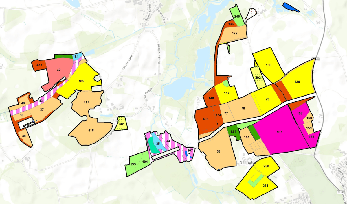

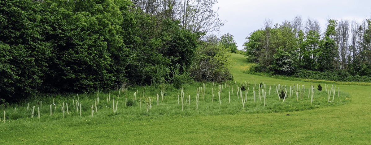


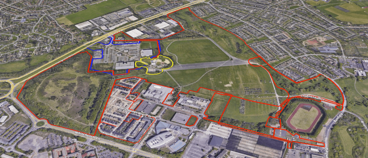
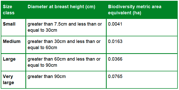
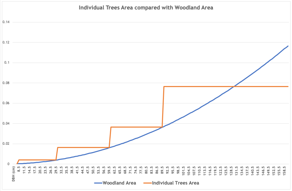
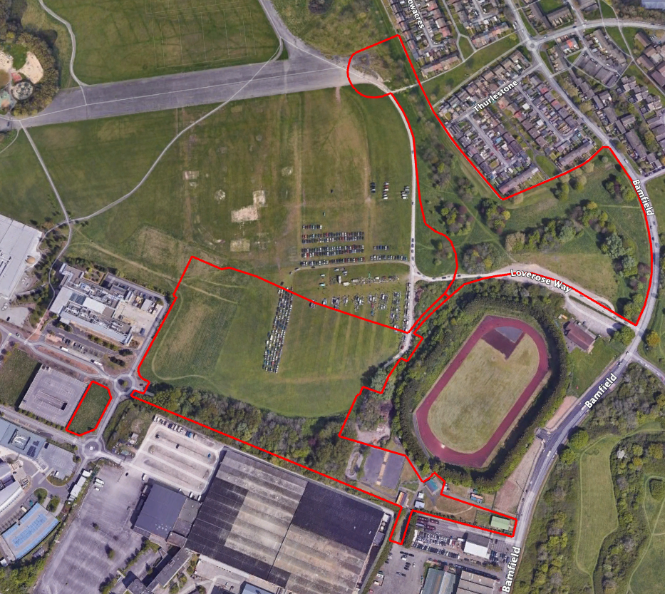
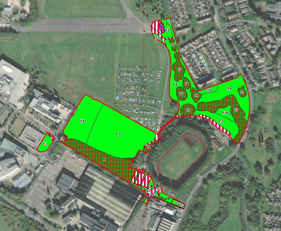
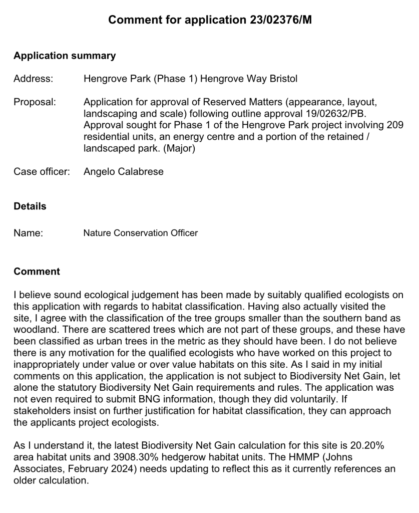
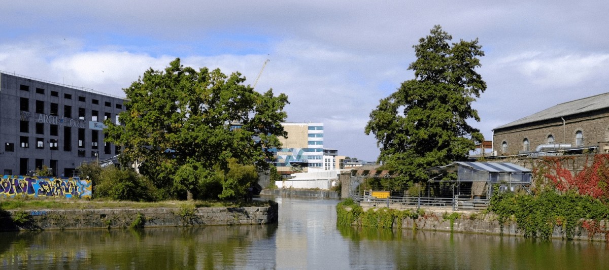
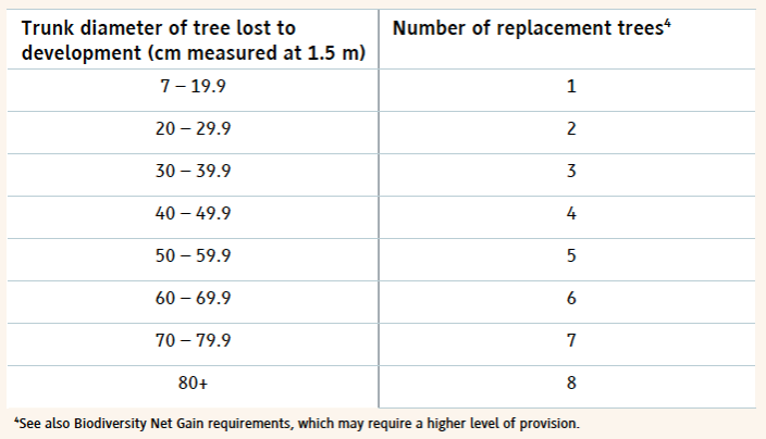

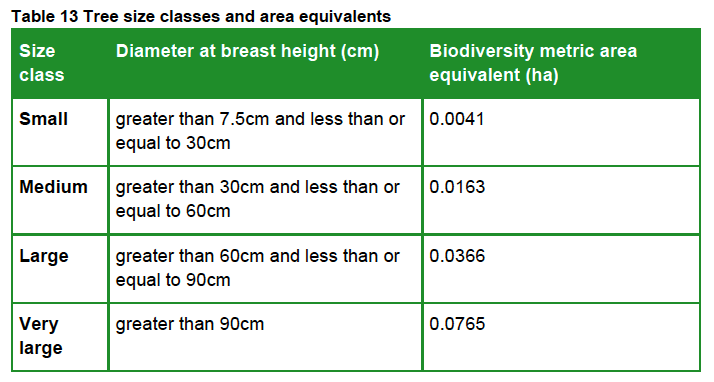
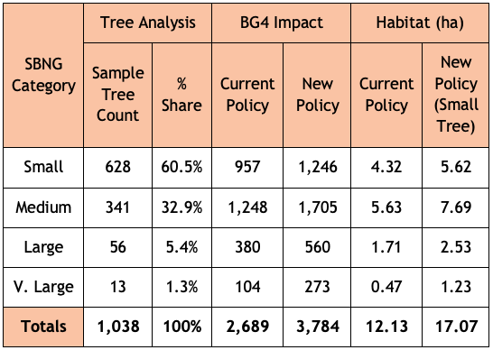
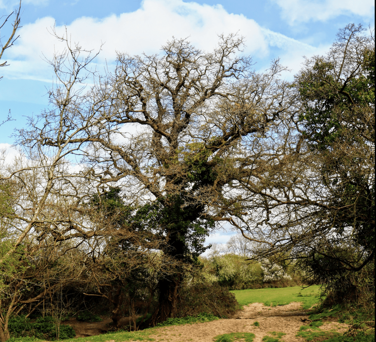
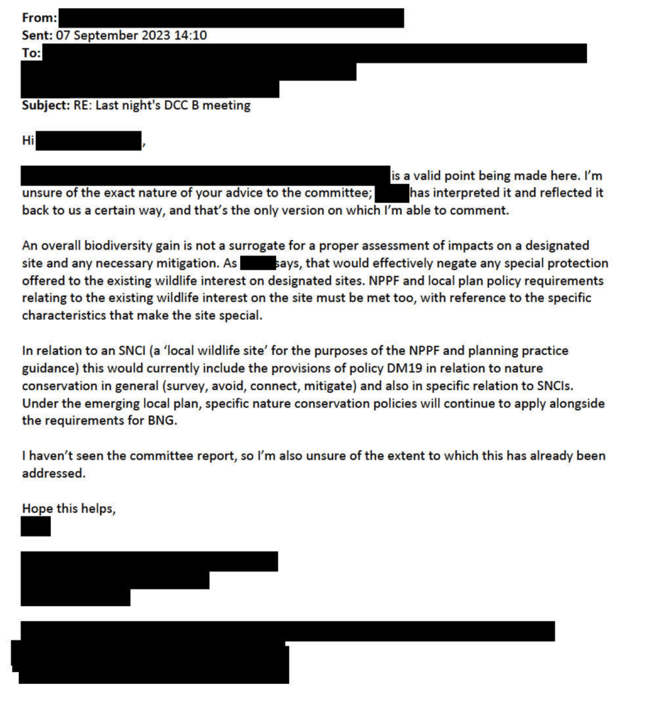
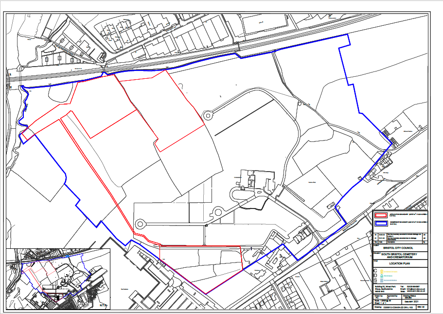
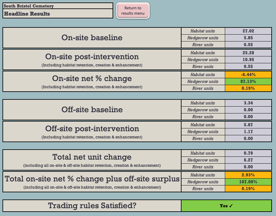
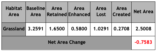
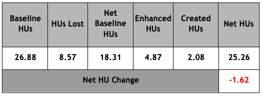
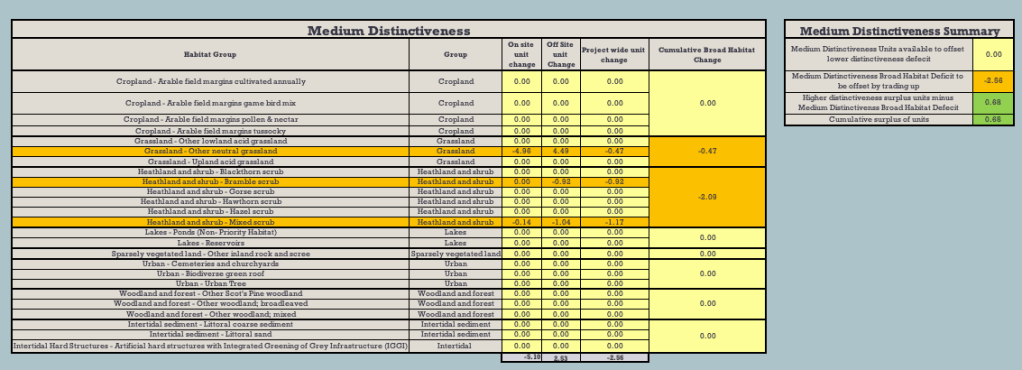
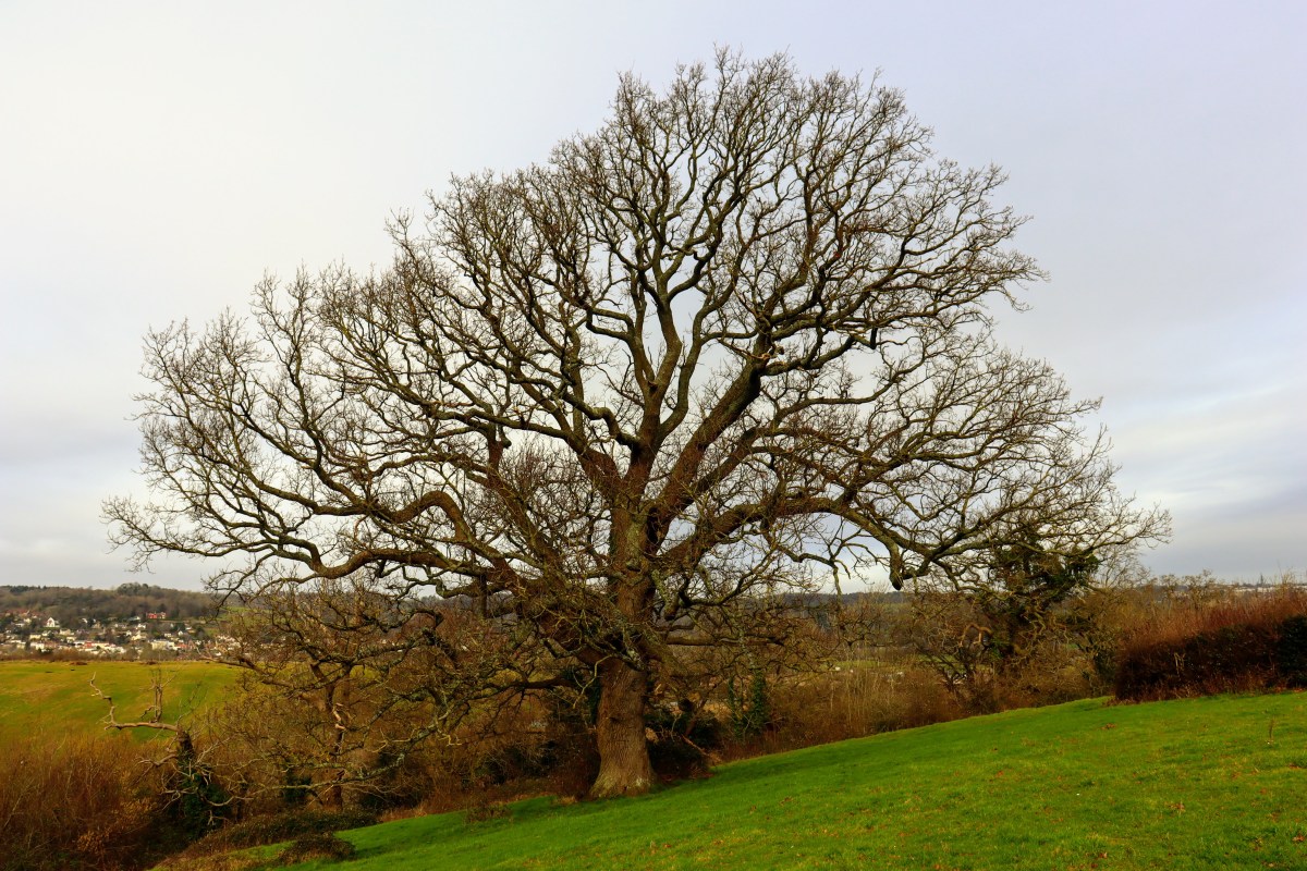

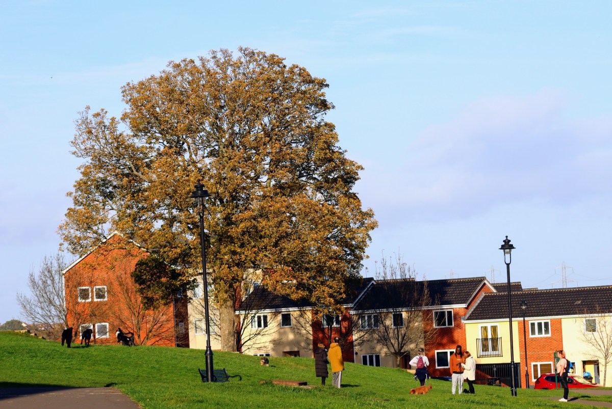
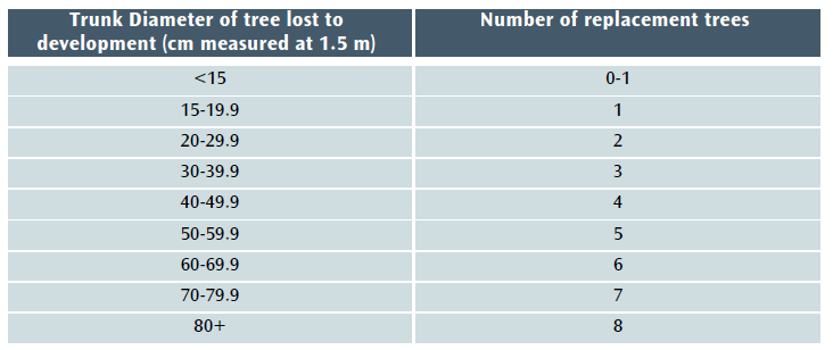
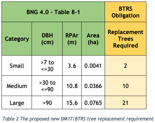
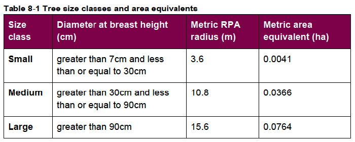
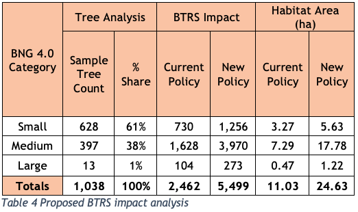
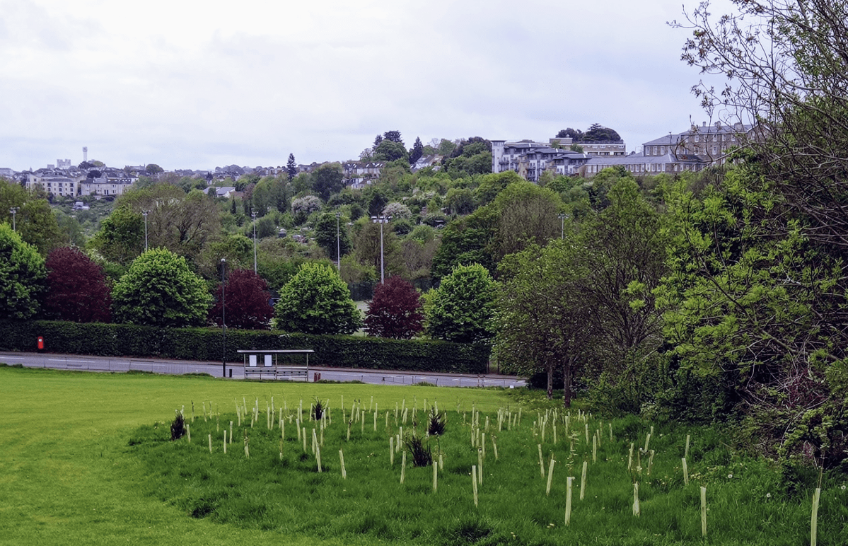
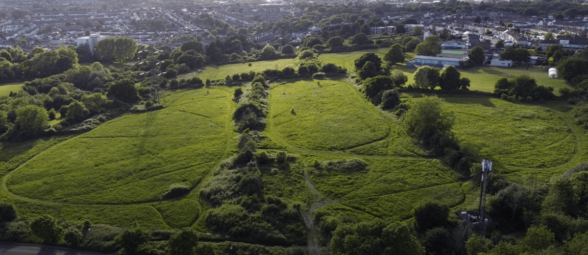
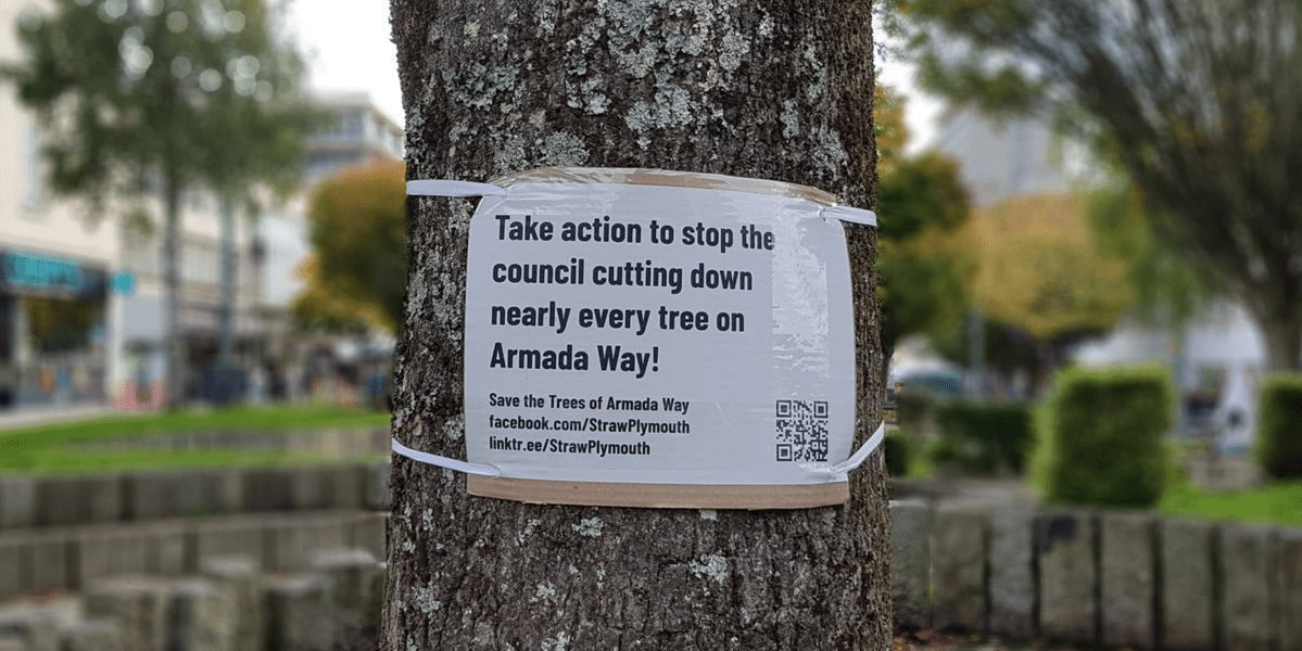

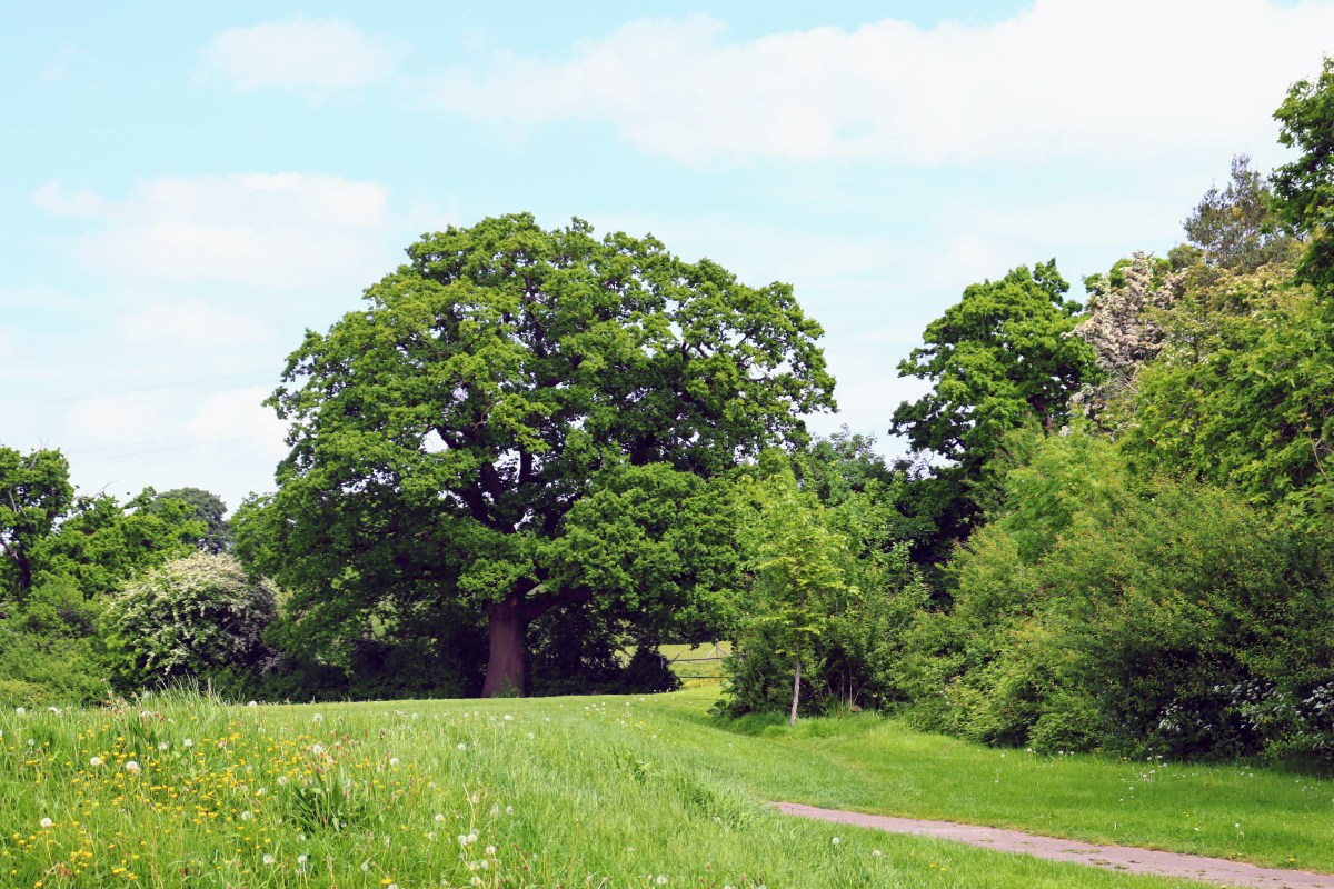

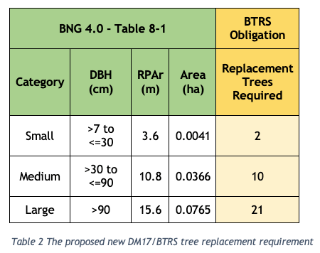
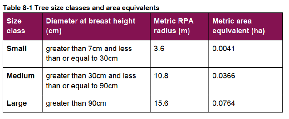

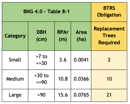

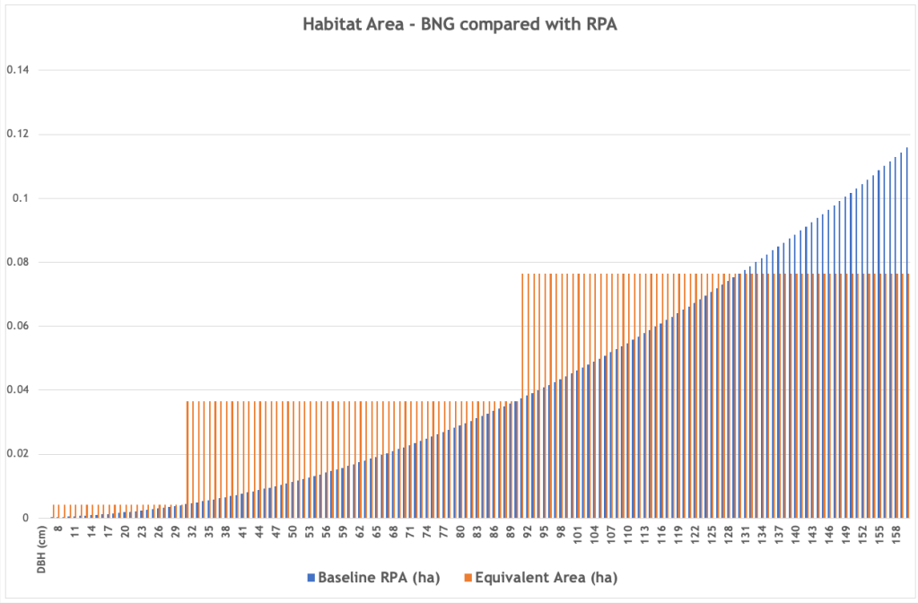

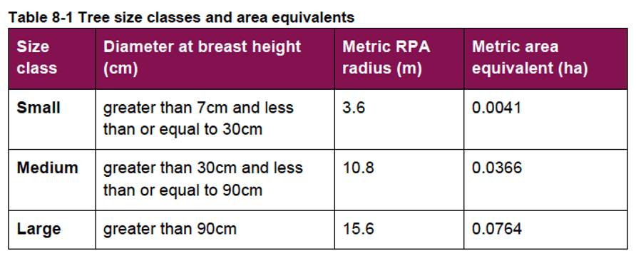


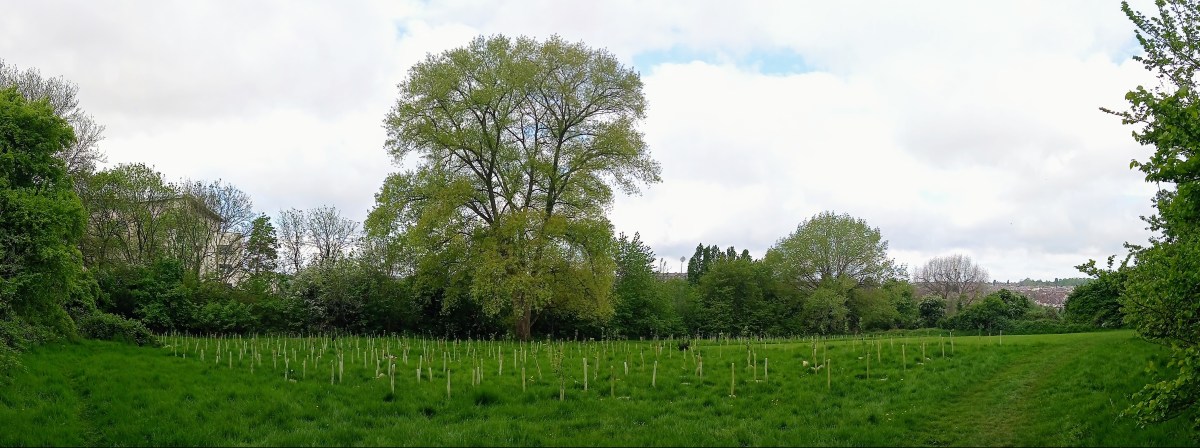
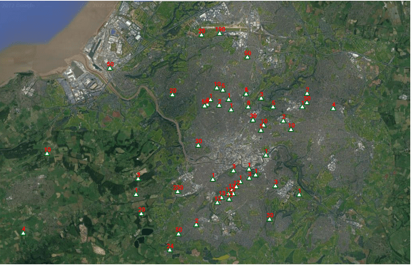
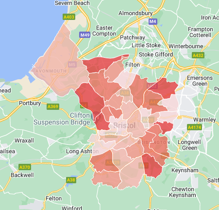
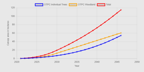
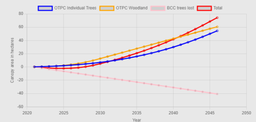
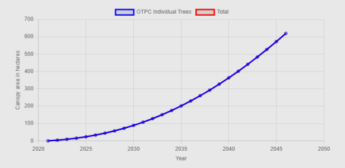

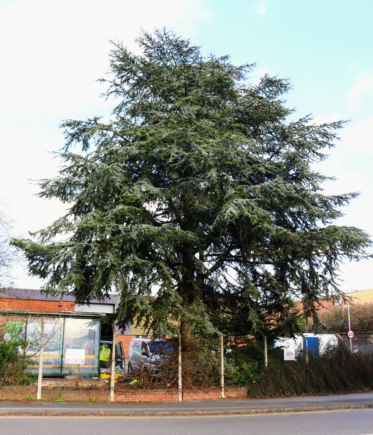
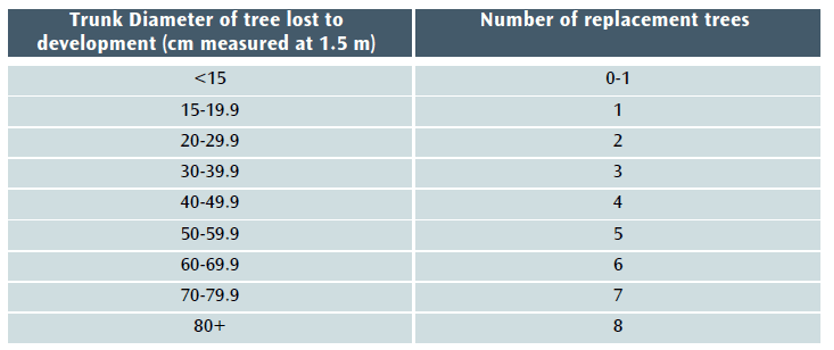
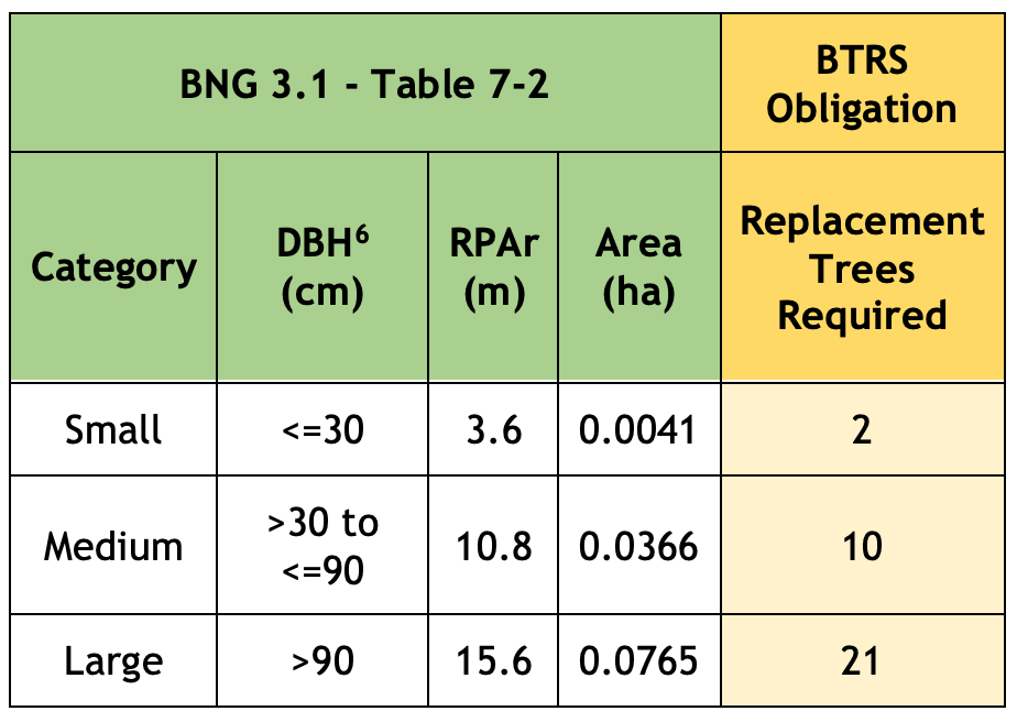
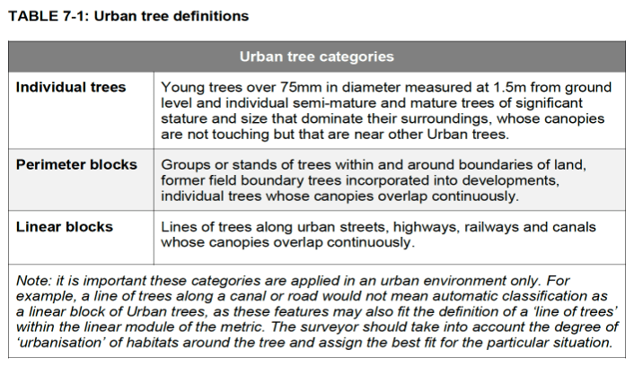


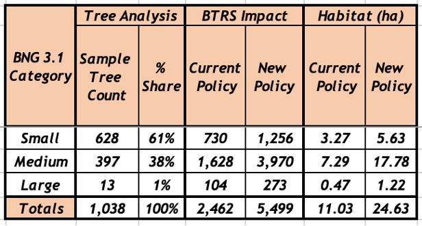
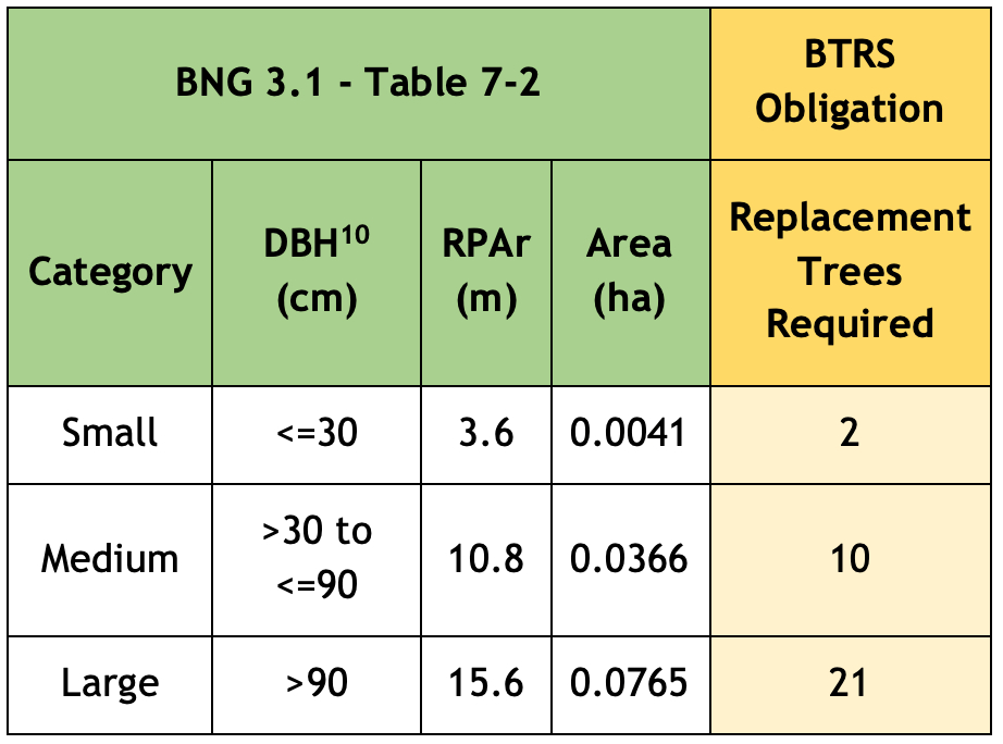
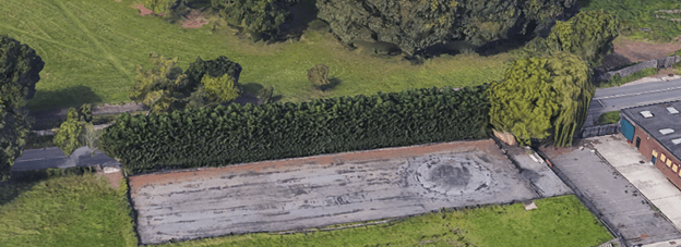
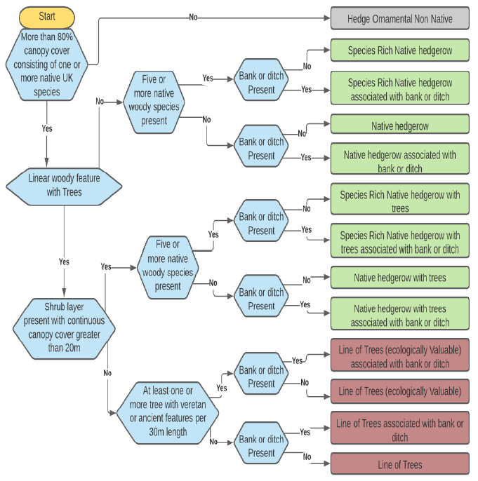


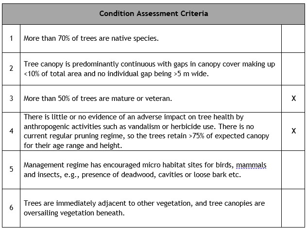

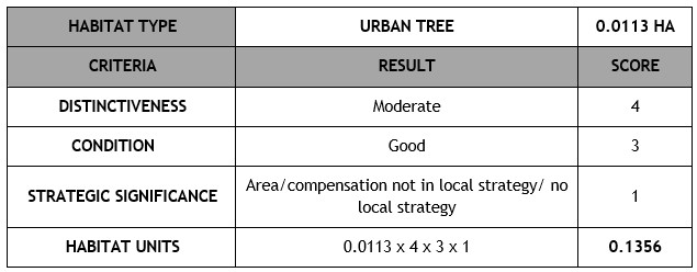
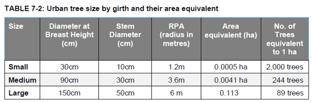
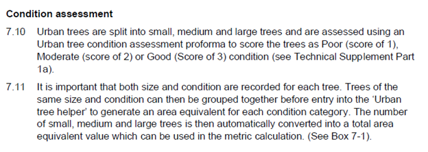
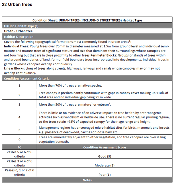
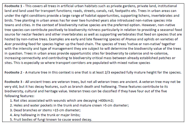

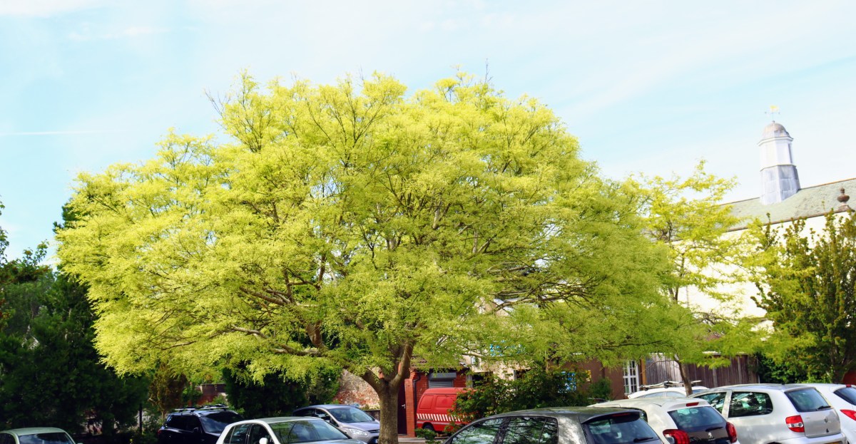
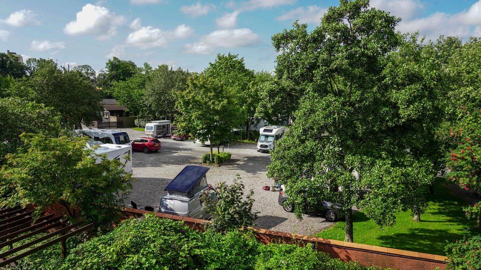
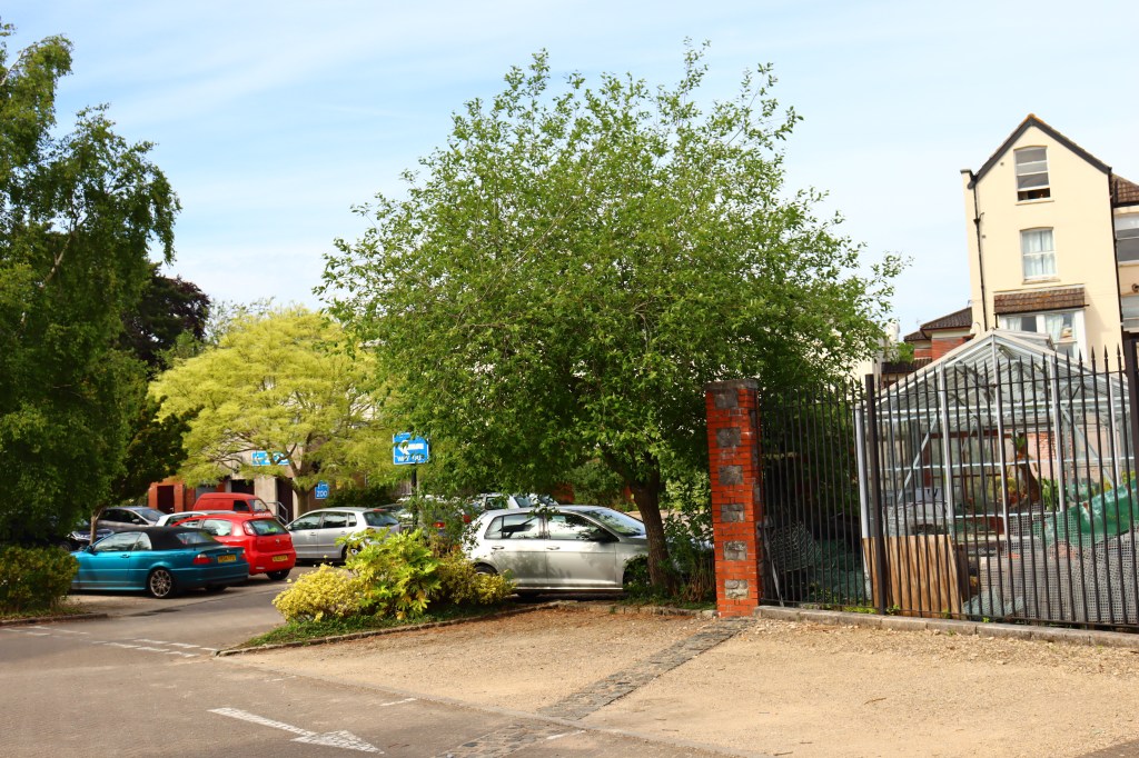
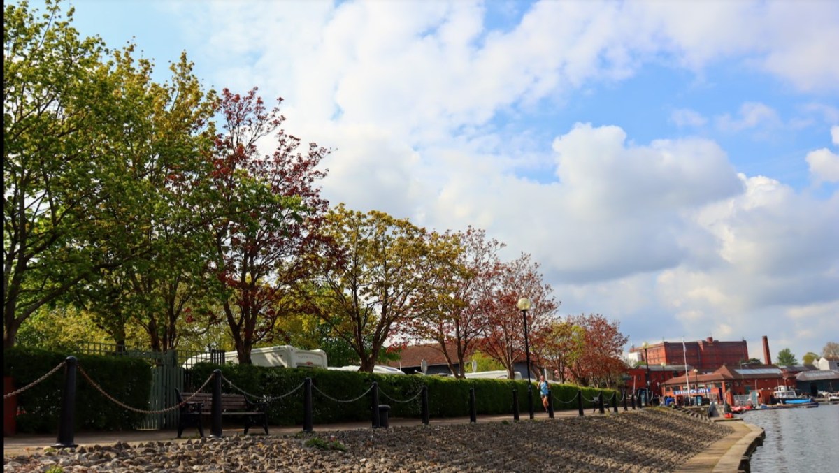
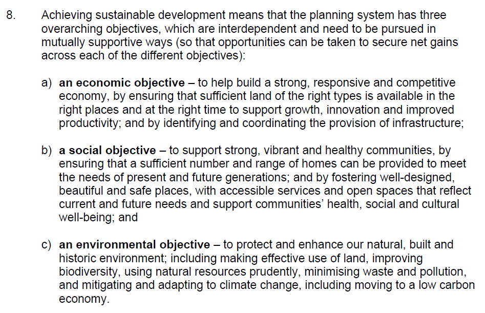
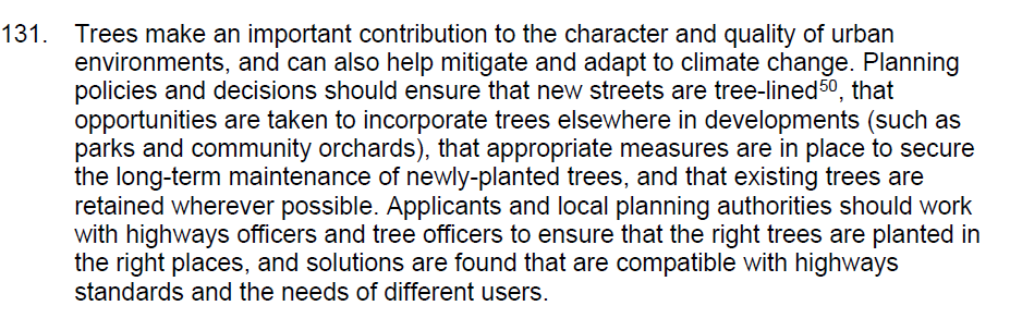

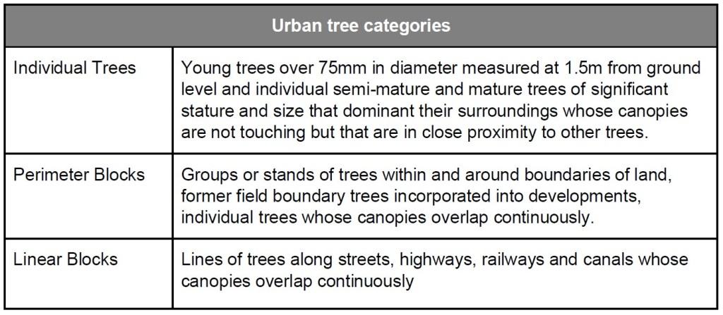
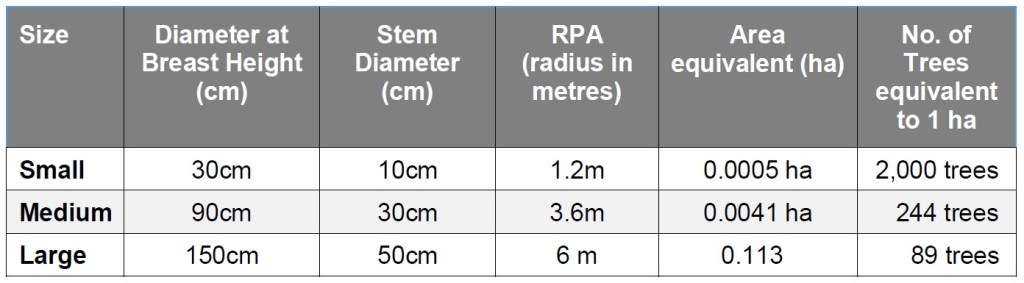
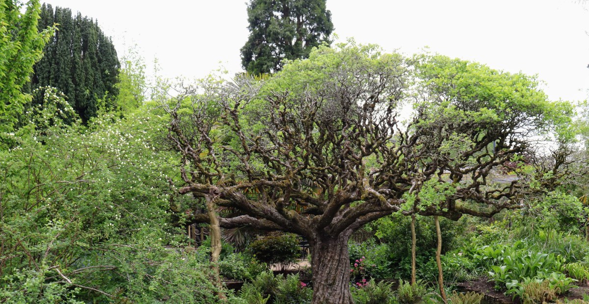
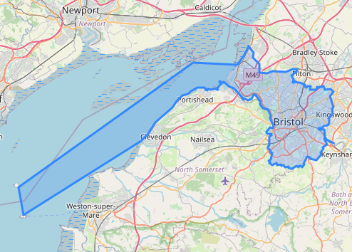
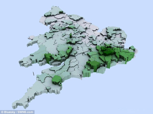
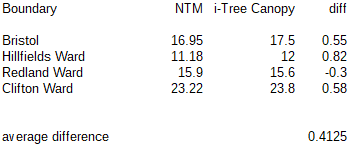
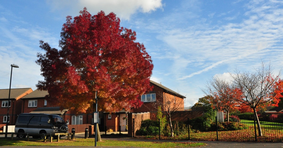
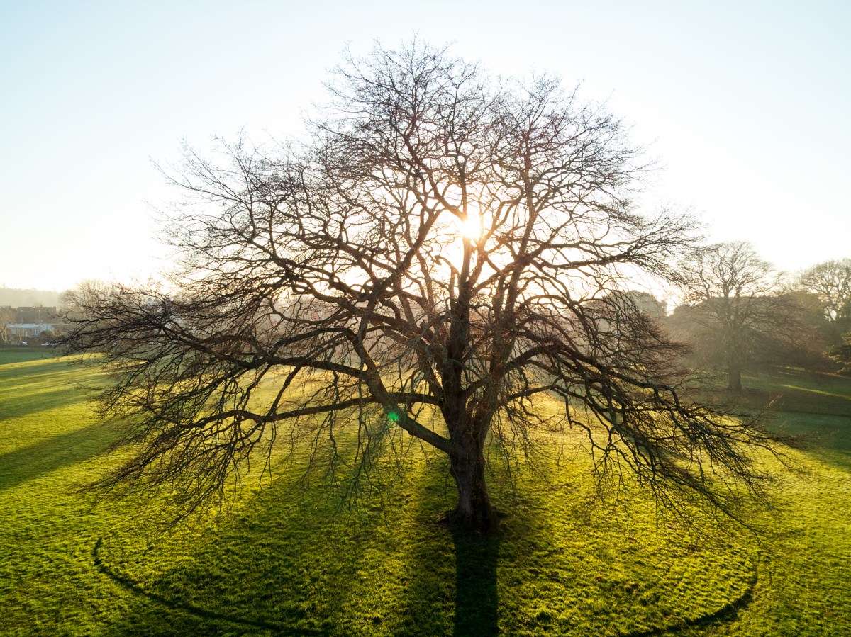

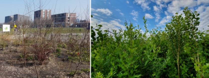
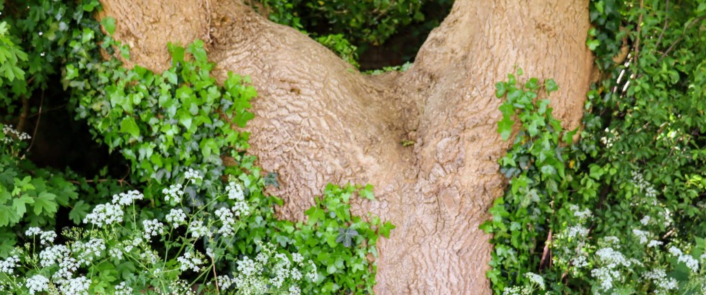


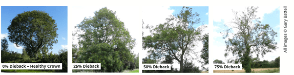

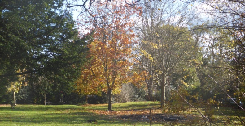
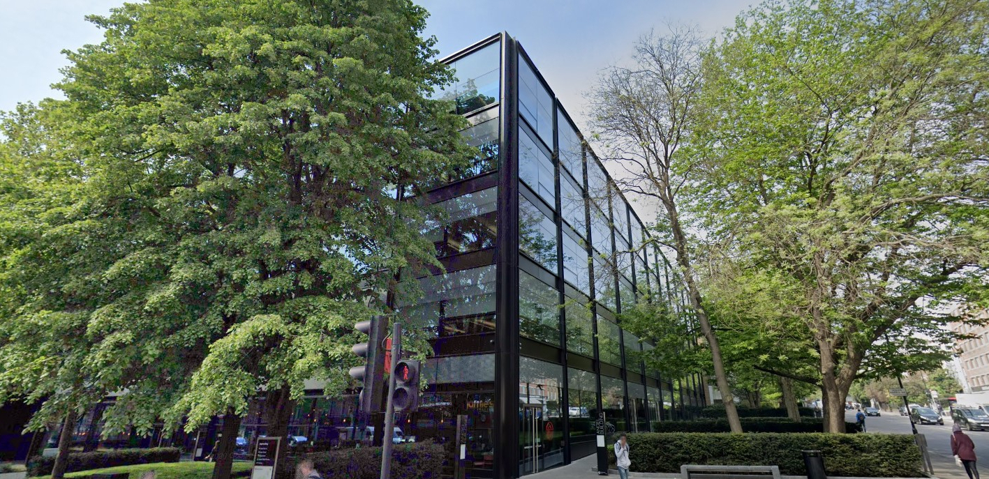


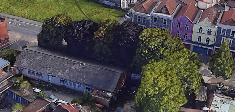
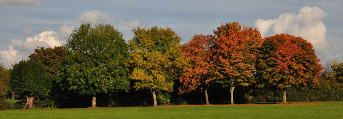
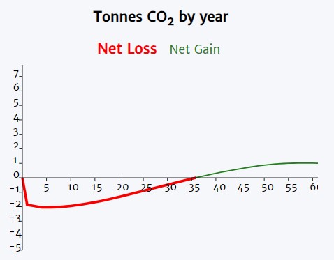
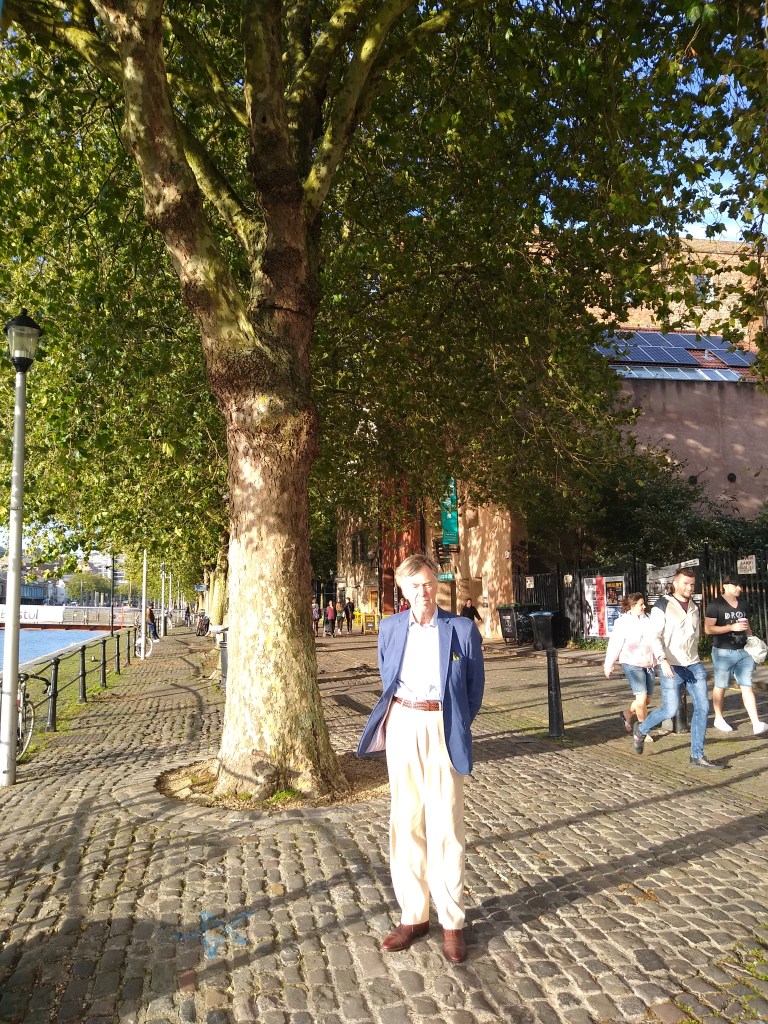
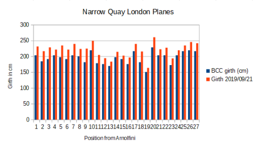
![By Unknown photographer; Collectie Anne Frank Stichting Amsterdam (Website Anne Frank Stichting, Amsterdam) [Public domain], via Wikimedia Commons](https://bristoltreeforum.org/wp-content/uploads/2018/06/annefrank1940_crop.jpg)

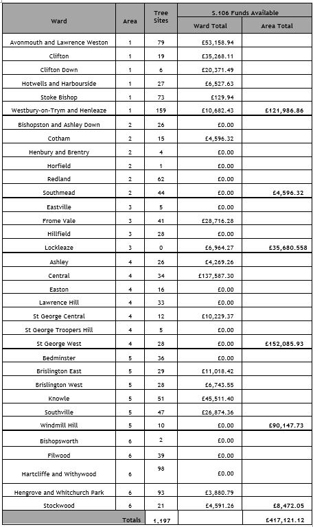 Background Notes
 We have now been able to establish that the Council felled 1,304 trees over the last three years. We have not yet been able to find what sort of trees they were or where they we located, but it is likely that most were located on streets. 363 street trees were planted over the same period.


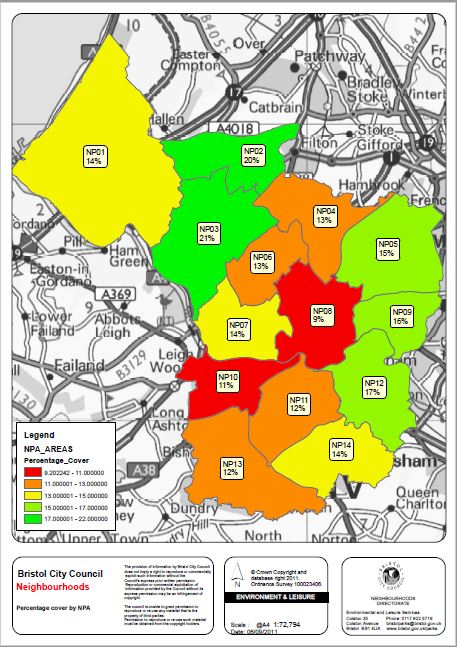


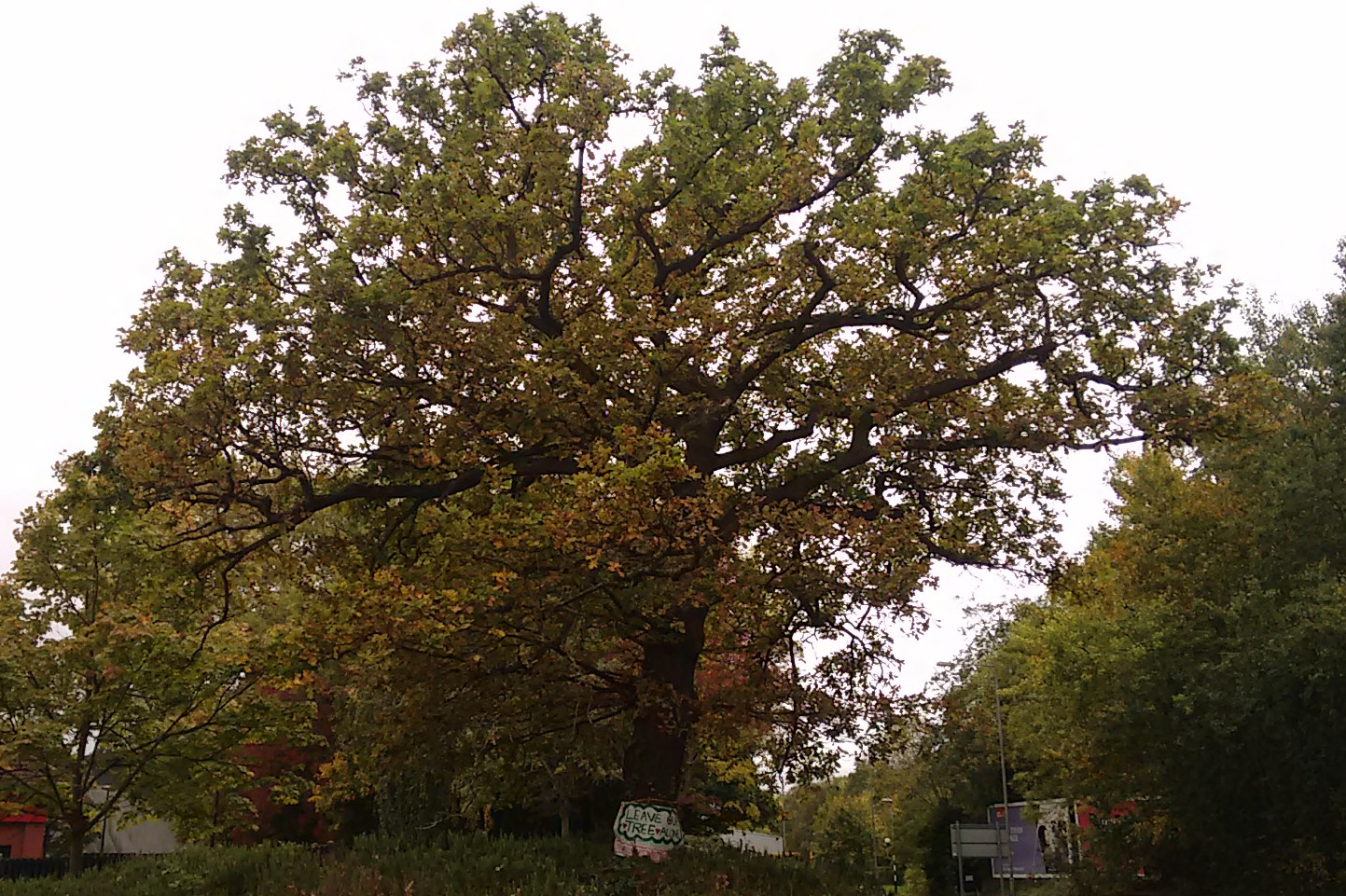 Over summer there was great public outcry about the loss of the prominent oak (